Filters: Tags: Phosphorus (X)
262 results (81ms)|
Filters
Date Range
Extensions Types Contacts
Categories Tag Types
|
Nitrogen, phosphorus, and suspended-sediment loads, and changes in loads, in major rivers across the Chesapeake Bay watershed have been calculated using monitoring data from the Chesapeake Bay River Input Monitoring (RIM) Network stations for the period 1985 through 2021. Nutrient and suspended-sediment loads and changes in loads were determined by applying a weighted regression approach called WRTDS (Weighted Regression on Time, Discharge, and Season). The load results represent the total mass of nitrogen, phosphorus, and suspended sediment that was exported from each of the RIM watersheds.
Categories: Data;
Types: Map Service,
OGC WFS Layer,
OGC WMS Layer,
OGC WMS Service;
Tags: Chesapeake Bay Watershed,
Delaware,
Kalman filtering,
Maryland,
New York,
This dataset records Cladophora and associated submerged aquatic vegetation (SAV) biomass collected approximately monthly during the growing season of 2019 at stations located along the U.S. shoreline of Lakes Michigan, Huron, Erie, and Ontario. It also records a variety of supporting data collected at Cladophora measurement stations. These supporting data include: - seasonal time series of light, currents, wave action, temperature, specific conductivity, turbidity, pH, phycocyanin, chlorophyll, and dissolved oxygen from moored sensors at a subset of stations; - measurements of Secchi disk depth and water chemistry; - water column profiles of temperature, specific conductivity, turbidity, pH, phycocyanin, chlorophyll,...
Categories: Data,
Data Release - Revised;
Tags: CTD measurement,
Great Lakes Region,
Lake Erie,
Lake Huron,
Lake Michigan,
Nitrogen, phosphorus, and suspended-sediment loads, and changes in loads, in major rivers across the Chesapeake Bay watershed have been calculated using monitoring data from the Chesapeake Bay River Input Monitoring (RIM) Network stations for the period 1985 through 2022. Nutrient and suspended-sediment loads and changes in loads were determined by applying a weighted regression approach called WRTDS (Weighted Regression on Time, Discharge, and Season). The load results represent the total mass of nitrogen, phosphorus, and suspended sediment that was exported from each of the RIM watersheds.
Categories: Data;
Types: Map Service,
OGC WFS Layer,
OGC WMS Layer,
OGC WMS Service;
Tags: Chesapeake Bay Watershed,
Delaware,
Kalman filtering,
Maryland,
New York,
These data are the primary data used to model rainbow trout growth in Glen Canyon. Fish growth data were collected from nighttime boat electrofishing field campaigns conducted five to six times per year in April, July, September, and January, from April 2012 through November 2021 for a total of 9798 observations of mark-recapture-based growth. Sampling was conducted in a five km reach in the lower portion of the Glen Canyon tailwater (3.7-8.9 km upstream of Lees Ferry, AZ). Two nights of sampling occurred on each trip, with the central 2-3 km of the reach sampled on both nights. After capture, fish were kept in aerated 40-L buckets and transported to a central processing location. Groups of 10-15 fish were anesthetized...

These data were released prior to the October 1, 2016 effective date for the USGS’s policy dictating the review, approval, and release of scientific data as referenced in USGS Survey Manual Chapter 502.8 Fundamental Science Practices: Review and Approval of Scientific Data for Release. This spatial data set was created by the U.S. Geological Survey (USGS) to represent the amount of fertilizer nitrogen and phosphorus that was applied to farm and nonfarm land in the Pacific Northwest region of the United States (Hydro Region 17; Major River Basin 7 (MRB7)) during 2002 within each incremental watershed delineated in the NHDPlus v2 dataset.
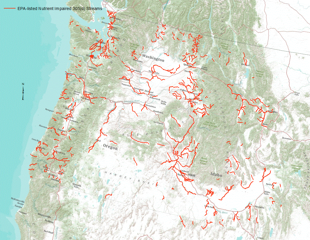
“Under section 303(d) of the 1972 Clean Water Act, states, territories, and authorized tribes are required to develop lists of impaired waters. These impaired waters do not meet water quality standards that states, territories, and authorized tribes have set for them, even after point sources of pollution have installed the minimum required levels of pollution control technology. The law requires that these jurisdictions establish priority rankings for waters on the lists and develop TMDLs for these waters” (U.S. Environmental Protection Agency, 2011). Waterways represented in this data set are a subset of these EPA 303 (d) listed streams that were classified as nutrient impaired. Nutrient impaired streams include...
Description of Work Participation on the Lake Erie Lakewide Management Plan Workgroup and related subcommittees such as toxics, sources and loads, nutrients, and biodiversity. Attend meetings and conferences associated with LE LAMP activities. This includes The Lake Erie Millennium Network, CSMI, Ohio Phosphorus Task Force, and other meetings or workshops addressing nutrient and toxicity issues in Lake Erie. Communicate USGS activities in the Lake Erie Basin that can influence understanding or impact decision making.
Categories: Project;
Types: Map Service,
OGC WFS Layer,
OGC WMS Layer,
OGC WMS Service;
Tags: Accountability,
Areas of concern,
Assessment,
Beneficial use impairment,
Binational,
Geostatistical analyses show that the distribution of soil N, P and K is strongly associated with the presence of shrubs in desert habitats. Shrubs concentrate the biogeochemical cycle of these elements in ?islands of fertility? that are localized beneath their canopies, while adjacent barren, intershrub spaces are comparatively devoid of biotic activity. Both physical and biological processes are involved in the formation of shrub islands. Losses of semiarid grassland in favor of invading shrubs initiate these changes in the distribution of soil nutrients, which may promote the further invasion and persistence of shrubs and cause potential feedbacks between desertification and the Earth's climate system. Published...
Categories: Publication;
Types: Citation,
Journal Citation;
Tags: Biogeochemistry,
Larrea tridentata,
Prosopis glandulosa,
Springer Netherlands,
aridisols,
A cvs file containing field datasets used to develop regression models to predict sediment and nutrient retention services for stream within the Difficult Run watershed. Field measurements of floodplain deposition and bank erosion were provided in previously published datasets from Hupp et al. (2013) and Gellis et al. (2017). At each field site 3-5 nearby cross-sections from the Toolbox where used to represent the floodplain and streambank sampling locations at the field sites. Metrics derived from the Toolbox are provided in this data table.
Categories: Data;
Types: Map Service,
OGC WFS Layer,
OGC WMS Layer,
OGC WMS Service;
Tags: Difficult Run,
Fairfax County,
Flood plains,
Fluvial morphology,
Virginia,
This dataset contains catchment-level estimates of nitrogen and phosphorus fertilizer use, for agricultural lands, for the conterminous U.S., for 2012. An approach was developed to relate farm commercial fertilizer sales data from the Association of American Plant Food Control Officials (AAPFCO) to a set of explanatory variables using spatially-referenced modeling methods. Separate models for nitrogen and phosphorus are developed to estimate elemental fertilizer use on agricultural lands for the conterminous U.S. at the National Hydrography Dataset Plus version 2 (NHDPlusV2) catchment scale. The approach builds on earlier efforts that use Association of American Plant Food Control Officials (AAPFCO) data on fertilizer...
Re-analyses of sample pulps and bulk rejects from historic USBM rock and heavy-mineral-concentrate samples were conducted by the Alaska Division of Geological & Geophysical Surveys (DGGS) as part of the State of Alaska's Strategic and Critical Minerals Assessment project, which is designed to evaluate Alaska's potential for these resources. The objective of this resource assessment is to expand the state's geochemical database by obtaining and publishing modern, quantitative geochemical analyses for historic USBM samples, where available. Highlights of this re-analysis project include heavy mineral concentrates with up 7,220 ppm Sn, 5,870 ppm Cr, and 17,000 ppm Mn.
Nitrogen, phosphorus, and suspended-sediment loads, and changes in loads, in major rivers across the Chesapeake Bay watershed have been calculated using monitoring data from the Chesapeake Bay River Input Monitoring (RIM) stations for the period 1985 through 2019. Nutrient and suspended-sediment loads and changes in loads were determined by applying a weighted regression approach called WRTDS (Weighted Regression on Time, Discharge, and Season). The load results represent the total mass of nitrogen, phosphorus, and suspended sediment that was exported from each of the RIM watersheds. To determine the trend in loads, the annual load results are flow normalized to integrate out the year-to-year variability in river...
Types: Map Service,
OGC WFS Layer,
OGC WMS Layer,
OGC WMS Service;
Tags: Chesapeake Bay Watershed,
Delaware,
Maryland,
New York,
Pennsylvania,
This data release consists of the data used to develop SPAtially Referenced Regression On Watershed(SPARROW) attributes models for estimating loads of total phosphorus and total nitrogen in Tennessee streams. These data support the publication containing the Tennessee SPARROW models results (Hoos and others, 2019) and include model input used in the South Atlantic-Gulf Drainages and Tennessee River Basin (SAGT) nutrient SPARROW models (Hoos and McMahon, 2009; Garcia and others, 2011) as well as model input for river basins in Tennessee not included in the domain of the published SAGT SPARROW models. Also included in this data release are model coefficients, the software required to execute the Tennessee SPARROW...
Nitrogen, phosphorus, and suspended-sediment loads, and changes in loads, in rivers across the Chesapeake Bay watershed have been calculated using monitoring data from the Chesapeake Bay Nontidal Network (NTN) stations for the period 1985 through 2018. Nutrient and suspended-sediment loads and changes in loads were determined by applying a weighted regression approach called WRTDS (Weighted Regression on Time, Discharge, and Season). The load results represent the total mass of nitrogen, phosphorus, and suspended sediment that was exported from each of the NTN watersheds. To determine the trend in loads, the annual load results are flow normalized to integrate out the year-to-year variability in river discharge....
Categories: Data;
Types: Map Service,
OGC WFS Layer,
OGC WMS Layer,
OGC WMS Service;
Tags: Chesapeake Bay Watershed,
Delaware,
Maryland,
New York,
Pennsylvania,
Nitrogen, phosphorus, and suspended-sediment loads, and changes in loads, in rivers across the Chesapeake Bay watershed have been calculated using monitoring data from the Chesapeake Bay Nontidal Network (NTN) stations for the period 1985 through 2018 Nutrient and suspended-sediment loads and changes in loads were determined by applying a weighted regression approach called WRTDS (Weighted Regression on Time, Discharge, and Season). The load results represent the total mass of nitrogen, phosphorus, and suspended sediment that was exported from each of the NTN watersheds. The file containing monthly loads for all applicable NTN monitoring stations is provided in the "Attached Files" section. First posted: February...
Categories: Data;
Types: Map Service,
OGC WFS Layer,
OGC WMS Layer,
OGC WMS Service;
Tags: Chesapeake Bay Watershed,
Delaware,
Maryland,
New York,
Pennsylvania,
Nitrogen, phosphorus, and suspended-sediment loads, and changes in loads, in rivers across the Chesapeake Bay watershed have been calculated using monitoring data from the Chesapeake Bay Nontidal Network (NTN) stations for the period 1985 through 2018. Nutrient and suspended-sediment loads and changes in loads were determined by applying a weighted regression approach called WRTDS (Weighted Regression on Time, Discharge, and Season). The load results represent the total mass of nitrogen, phosphorus, and suspended sediment that was exported from each of the NTN watersheds. The files containing all inputs required to run WRTDS for all applicable NTN monitoring stations are provided in the "Attached Files" section.
Categories: Data;
Types: Map Service,
OGC WFS Layer,
OGC WMS Layer,
OGC WMS Service;
Tags: Chesapeake Bay Watershed,
Delaware,
Maryland,
New York,
Pennsylvania,
Nitrogen, phosphorus, and suspended-sediment loads, and changes in loads, in major rivers across the Chesapeake Bay watershed have been calculated using monitoring data from the Chesapeake Bay River Input Monitoring (RIM) Network stations for the period 1985 through 2020. Nutrient and suspended-sediment loads and changes in loads were determined by applying a weighted regression approach called WRTDS (Weighted Regression on Time, Discharge, and Season). The load results represent the total mass of nitrogen, phosphorus, and suspended sediment that was exported from each of the RIM watersheds.
Categories: Data;
Types: Map Service,
OGC WFS Layer,
OGC WMS Layer,
OGC WMS Service;
Tags: Chesapeake Bay Watershed,
Delaware,
Kalman filtering,
Maryland,
New York,
This metadata record documents 3 sets of comma delimited tables representing the amount of reported best management practice (BMP) implementation within the Chesapeake Bay watershed as well as output data from scenarios of the Chesapeake Bay Program Phase 5.3.2 Watershed Model. The scenario data were used to estimate the effects of BMPs on water quality. The data are organized by three themes (child items below); 1) BMP implementation and definitions, 2) isolation scenarios, and 3) "Progress" and "No Action" scenarios.
Here we archive data collected during a nitrogen addition field experiment in the Sacramento River Deep Water Ship Channel. Calcium nitrate was added on 8 dates to a segment of the ship channel centered at Navigation Light 74. Prior to and following the nutrient additions, we collected water samples and sensor-based measurements at 7 sites between Navigation Light 70 and 76. Water samples for nutrient analyses were collected in 500 mL High Density Poly Ethylene (HDPE) amber containers from 1 m and 8 m depths using a peristaltic pump. Whole water samples for phytoplankton analysis were collected from 1 m depth in 500 mL clear HDPE containers and immediately preserved with 20 mL of Lugol’s iodine solution (Lugol’s,...
Categories: Data;
Tags: Sacramento River,
Sacramento River Deep Water Ship Channel,
Sacramento–San Joaquin Delta,
Temperature,
West Sacramento,
|

|
