Filters: Tags: Pond (X) > Types: Map Service (X)
3 results (9ms)|
Filters
Date Range
Extensions Types Contacts
Categories Tag Types Tag Schemes |
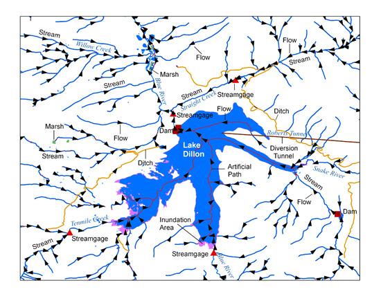
The National Hydrography Dataset (NHD) High Resolution flowlines were used as a base to provide additional information on the connectivity of the stream network for the hydrographic basins in and around Montana. In addition to the attributes that are published as part of the NHD data, two fields were added to the attribute table to associate streams that do not have a Geographic Names Information System (GNIS) name with the GNIS name and NHD reachcode of the nearest downstream named flowline. The National Hydrography Dataset (NHD) is a feature-based database that interconnects and uniquely identifies the stream segments or reaches that make up the nation's surface water drainage system. NHD data were originally...
Types: Map Service,
OGC WFS Layer,
OGC WMS Layer,
OGC WMS Service;
Tags: Geography,
Idaho,
Information Sciences,
MSDI,
Montana,
Combined storage (palustrine, riverine, or lacustrine) data from U.S. Fish and Wildlife Service National Wetlands Inventory (NWI) - https://www.fws.gov/wetlands/, Canadian National Hydrographic Network (NHN) - http://www.snb.ca/geonb1/e/dc/catalogue-E.asp, and North American Land Change Monitoring System Landcover - https://www.mrlc.gov/data. Grid values equal to 1 are storage areas and grid values equal to 0 are NoData areas.
Types: Map Service,
OGC WFS Layer,
OGC WMS Layer,
OGC WMS Service;
Tags: Maine,
geographic information systems,
lacustrine,
lake,
palustrine,

The USGS National Hydrography Dataset (NHD) service from The National Map (TNM) is a comprehensive set of digital spatial data that encodes information about naturally occurring and constructed bodies of surface water (lakes, ponds, and reservoirs), paths through which water flows (canals, ditches, streams, and rivers), and related entities such as point features (springs, wells, stream gages, and dams). The information encoded about these features includes classification and other characteristics, delineation, geographic name, position and related measures, a "reach code" through which other information can be related to the NHD, and the direction of water flow. The network of reach codes delineating water and...
Categories: Data;
Types: ArcGIS REST Map Service,
Map Service;
Tags: HU,
Hydrography,
NGP-TNM,
NHD,
Overlay Map Service,
|

|