Filters: Tags: Rangeland (X)
88 results (39ms)|
Filters
Date Range
Extensions Types Contacts
Categories Tag Types
|
Defining site potential for an area establishes its possible long-term vegetation growth productivity in a relatively undisturbed state, providing a realistic reference point for ecosystem performance. Modeling and mapping site potential helps to measure and identify naturally occurring variations on the landscape as opposed to variations caused by land management activities or disturbances (Rigge et al. 2020). We integrated remotely sensed data (250-m enhanced Moderate Resolution Imaging Spectroradiometer (eMODIS) Normalized Difference Vegetation Index (NDVI) (https://earthexplorer.usgs.gov/)) with land cover, biogeophysical (i.e., soils, topography) and climate data into regression-tree software (Cubist®). We...
Categories: Data;
Types: Downloadable,
GeoTIFF,
Map Service,
Raster;
Tags: Arid,
Arizona,
Colorado,
Ecology,
Geography,
The RCMAP (Rangeland Condition Monitoring Assessment and Projection) dataset quantifies the percent cover of rangeland components across western North America using Landsat imagery from 1985-2023. The RCMAP product suite consists of ten fractional components: annual herbaceous, bare ground, herbaceous, litter, non-sagebrush shrub, perennial herbaceous, sagebrush, shrub, tree, and shrub height in addition to the temporal trends of each component. Several enhancements were made to the RCMAP process relative to prior generations. First, high-resolution training was revised using an improved neural-net classifier and modelling approach. These data serve as foundation to the RCMAP approach. The training database was...
The RCMAP (Rangeland Condition Monitoring Assessment and Projection) dataset quantifies the percent cover of rangeland components across western North America using Landsat imagery from 1985-2023. The RCMAP product suite consists of ten fractional components: annual herbaceous, bare ground, herbaceous, litter, non-sagebrush shrub, perennial herbaceous, sagebrush, shrub, tree, and shrub height in addition to the temporal trends of each component. Several enhancements were made to the RCMAP process relative to prior generations. First, high-resolution training was revised using an improved neural-net classifier and modelling approach. These data serve as foundation to the RCMAP approach. The training database was...
The need to monitor change in sagebrush steppe is urgent due to the increasing impacts of climate change, shifting fire regimes, and management practices on ecosystem health. Remote sensing provides a cost-effective and reliable method for monitoring change through time and attributing changes to drivers. We report an automated method of mapping rangeland fractional component cover over a large portion of the Northern Great Basin, USA, from 1986 to 2016 using a dense Landsat imagery time series. 2012 was excluded from the time-series due to a lack of quality imagery. Our method improved upon the traditional change vector method by considering the legacy of change at each pixel. We evaluate cover trends stratified...

The datatset is a compilation of all permanent (legally established) protected areas in British Columbia, Canada.
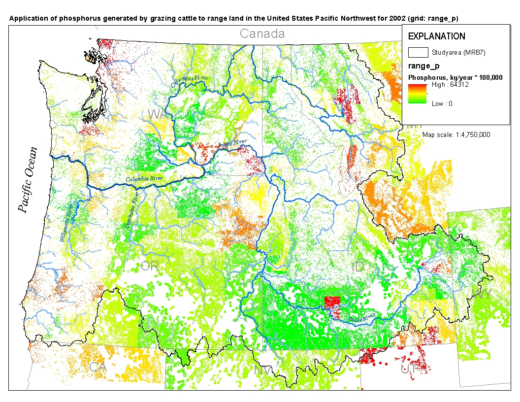
This spatial data set was created by the U.S. Geological Survey (USGS) to represent the amount of phosphorus generated by grazing cattle that was applied to range land in the Pacific Northwest region of the United States (Hydro Region 17; Major River Basin 7 (MRB7)) during 2002.
The RCMAP (Rangeland Condition Monitoring Assessment and Projection) dataset quantifies the percent cover of rangeland components across the western U.S. using Landsat imagery from 1985-2020. The RCMAP product suite consists of eight fractional components: annual herbaceous, bare ground, herbaceous, litter, non-sagebrush shrub, perennial herbaceous, sagebrush, shrub and rule-based error maps including the temporal trends of each component. Several enhancements were made to the RCMAP process relative to prior generations. We used an updated version of the 2016 base training data, with a more aggressive forest mask and reduced shrub and sagebrush cover bias in pinyon-juniper woodlands. We pooled training data in areas...
The RCMAP (Rangeland Condition Monitoring Assessment and Projection) dataset quantifies the percent cover of rangeland components across the western U.S. using Landsat imagery from 1985-2020. The RCMAP product suite consists of eight fractional components: annual herbaceous, bare ground, herbaceous, litter, non-sagebrush shrub, perennial herbaceous, sagebrush, shrub and rule-based error maps including the temporal trends of each component. Several enhancements were made to the RCMAP process relative to prior generations. We used an updated version of the 2016 base training data, with a more aggressive forest mask and reduced shrub and sagebrush cover bias in pinyon-juniper woodlands. We pooled training data in areas...
The RCMAP (Rangeland Condition Monitoring Assessment and Projection) dataset quantifies the percent cover of rangeland components across the western U.S. using Landsat imagery from 1985-2021. The RCMAP product suite consists of nine fractional components: annual herbaceous, bare ground, herbaceous, litter, non-sagebrush shrub, perennial herbaceous, sagebrush, shrub, and tree, in addition to the temporal trends of each component. Several enhancements were made to the RCMAP process relative to prior generations. First, we have trained time-series predictions directly from 331 high-resolution sites collected from 2013-2018 from Assessment, Inventory, and Monitoring (AIM) instead of using the 2016 “base” map as an intermediary....
The RCMAP (Rangeland Condition Monitoring Assessment and Projection) dataset quantifies the percent cover of rangeland components across the western U.S. using Landsat imagery from 1985-2020. The RCMAP product suite consists of eight fractional components: annual herbaceous, bare ground, herbaceous, litter, non-sagebrush shrub, perennial herbaceous, sagebrush, shrub and rule-based error maps including the temporal trends of each component. Several enhancements were made to the RCMAP process relative to prior generations. We used an updated version of the 2016 base training data, with a more aggressive forest mask and reduced shrub and sagebrush cover bias in pinyon-juniper woodlands. We pooled training data in areas...
The need to monitor change in sagebrush steppe is urgent due to the increasing impacts of climate change, shifting fire regimes, and management practices on ecosystem health. Remote sensing provides a cost-effective and reliable method for monitoring change through time and attributing changes to drivers. We report an automated method of mapping rangeland fractional component cover over a large portion of the Northern Great Basin, USA, from 1986 to 2016 using a dense Landsat imagery time series. 2012 was excluded from the time-series due to a lack of quality imagery. Our method improved upon the traditional change vector method by considering the legacy of change at each pixel. We evaluate cover trends stratified...
Mitigation of ecological damage caused by rangeland wildfires has historically been an issue restricted to the western United States. It has focused on conservation of ecosystem function through reducing soil erosion and spread of invasive plants. Effectiveness of mitigation treatments has been debated recently. We searched for literature on postfire seeding of rangelands worldwide. Literature databases searched included SCOPUS, Dissertation Abstracts, Forest Science, Tree search, Web of Science, Google Scholar, and science.gov. Search terms within publications included fire or wildfire in combination with seeding, rehabilitation, restoration, revegetation, stabilization, chaining, disking, drilling, invasives,...
Categories: Data;
Types: Citation;
Tags: Ecology,
Land Use Change,
USGS Science Data Catalog (SDC),
chaining,
cheatgrass,
This feature class includes monitoring data collected nationally to understand the status, condition, and trend of resources on BLM lands. Data are collected in accordance with the BLM Assessment, Inventory, and Monitoring (AIM) Strategy. The AIM Strategy specifies a probabilistic sampling design, standard core indicators and methods, electronic data capture and management, and integration with remote sensing. Attributes include the BLM terrestrial core indicators: bare ground, vegetation composition, plant species of management concern, non-native invasive species, and percent canopy gaps (see Entity/Attribute Section for exact details on attributes). Data were collected and managed by BLM Field Offices, BLM Districts,...
Many aspects of recurring plant developmental events – vegetation phenology – are measured by remote sensing. By consistently measuring the timing and magnitude of the growing season, it is possible to study the complex relationships among drivers of the seasonal cycle of vegetation, including legacy conditions. We studied the role of current and legacy climate, and contextual factors on the land surface phenology of the U.S. Northern Great Plains. Specifically, we used annual and seasonal climate variables (e.g., temperature, precipitation, growing degree days, and vapor pressure deficit) covering the current year and the past four years derived from the PRISM climate dataset. We also included soils, disturbance,...

These data were released prior to the October 1, 2016 effective date for the USGS’s policy dictating the review, approval, and release of scientific data as referenced in USGS Survey Manual Chapter 502.8 Fundamental Science Practices: Review and Approval of Scientific Data for Release. This spatial data set was created by the U.S. Geological Survey (USGS) to represent the amount of nitrogen generated by grazing cattle that was applied to range land in the Pacific Northwest region of the United States (Hydro Region 17; Major River Basin 7 (MRB7)) during 2002.
The RCMAP (Rangeland Condition Monitoring Assessment and Projection) dataset quantifies the percent cover of rangeland components across western North America using Landsat imagery from 1985-2023. The RCMAP product suite consists of ten fractional components: annual herbaceous, bare ground, herbaceous, litter, non-sagebrush shrub, perennial herbaceous, sagebrush, shrub, tree, and shrub height in addition to the temporal trends of each component. Several enhancements were made to the RCMAP process relative to prior generations. First, high-resolution training was revised using an improved neural-net classifier and modelling approach. These data serve as foundation to the RCMAP approach. The training database was...
The need to monitor change in sagebrush steppe is urgent due to the increasing impacts of climate change, shifting fire regimes, and management practices on ecosystem health. Remote sensing provides a cost-effective and reliable method for monitoring change through time and attributing changes to drivers. We report an automated method of mapping rangeland fractional component cover over a large portion of the Northern Great Basin, USA, from 1986 to 2016 using a dense Landsat imagery time series. 2012 was excluded from the time-series due to a lack of quality imagery. Our method improved upon the traditional change vector method by considering the legacy of change at each pixel. We evaluate cover trends stratified...
This data release has been superseded by version 3.0, available here: https://doi.org/10.5066/P9MJVQSQ Quantifying Western U.S. shrublands as a series of fractional components with remote sensing provides a new way to understand these changing ecosystems. The USGS NLCD team in collaboration with the BLM has produced the most comprehensive remote sensing-based quantification of Western U.S. shrublands to date. Nine shrubland ecosystem components, including percent shrub, sagebrush (Artemisia spp.), big sagebrush, herbaceous, annual herbaceous, litter, and bare ground cover, along with sagebrush and shrub heights, were quantified at 30-m resolution by mapping region. Each region required extensive ground measurement...
Categories: Data Release - Revised;
Tags: AZ,
Arizona,
Arizona Plateau,
Black Hills,
Blue Mountains,
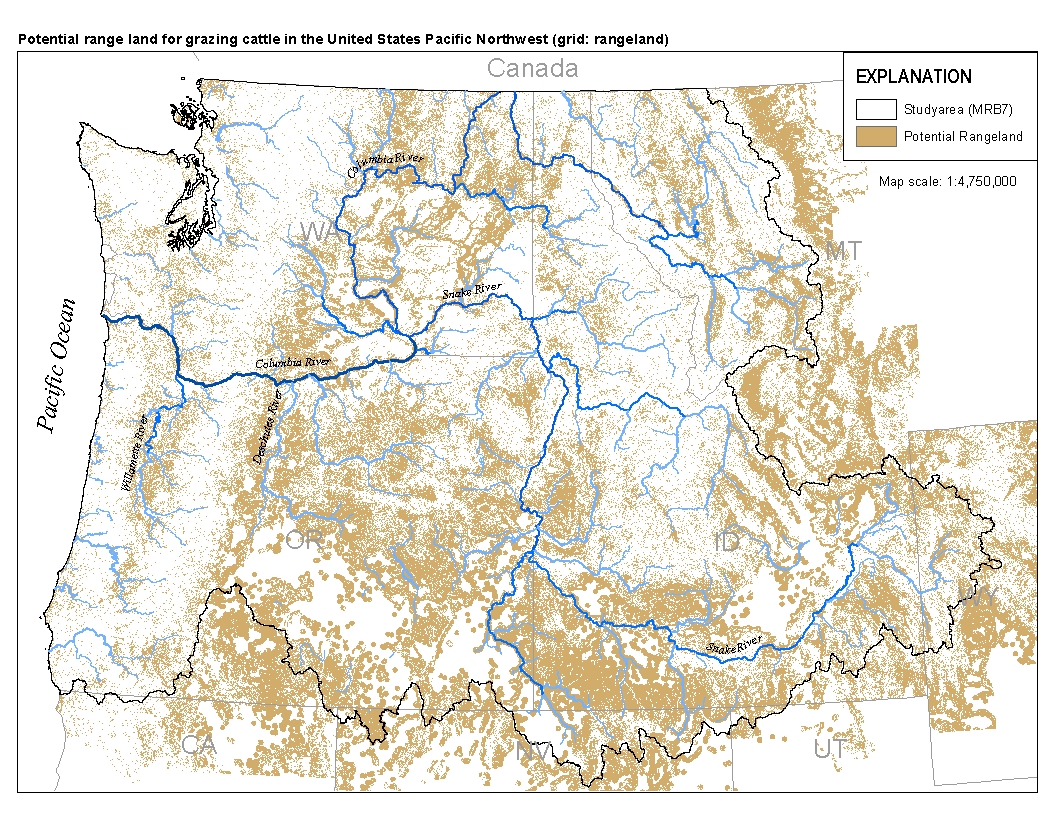
This spatial data set was created by the U.S. Geological Survey (USGS) to represent the extent of land in the Pacific Northwest region of the United States (Hydro Region 17; Major River Basin 7 (MRB7)) that potentially received waste from grazing cattle in 2002.
Invasion of the exotic annual grass Bromus tectorum into stands of the native perennial grass Hilaria jamesii significantly reduced the abundance of soil biota, especially microarthropods and nematodes. Effects of invasion on active and total bacterial and fungal biomass were variable, although populations generally increased after 50+ years of invasion. The invasion of Bromus also resulted in a decrease in richness and a species shift in plants, microarthropods, fungi, and nematodes. However, despite the depauperate soil fauna at the invaded sites, no effects were seen on cellulose decomposition rates, nitrogen mineralization rates, or vascular plant growth. When Hilaria was planted into soils from not-invaded,...
Categories: Publication;
Types: Citation,
Journal Citation;
Tags: Ecology,
decomposition,
desert grassland,
ecological legacy,
microarthropods,
|

|
