Filters: Tags: Remote Sensing (X) > Types: Citation (X)
111 results (10ms)|
Filters
Date Range
Extensions Types
Contacts
Categories Tag Types
|
Snow covered area (SCA) observations from the Landsat Enhanced Thematic Mapper (ETM+) were used in combination with a distributed snowmelt model to estimate snow water equivalent (SWE) in the headwaters of the Rio Grande basin (3,419 km2) - a spatial scale that is an order of magnitude greater than previous reconstruction model applications. In this reconstruction approach, modeled snowmelt over each pixel is integrated over the time of ETM+ observed snow cover to estimate SWE. Considerable differences in the magnitude of SWE were simulated during the study. Basin-wide mean SWE was 2�6 times greater in April 2001 versus 2002. Despite these climatological differences, the model adequately recovered SWE at intensive...
Categories: Publication;
Types: Citation,
Journal Citation;
Tags: Hydrological Processes,
modeling,
remote sensing,
snow and ice,
snowmelt,
The evapotranspiration (ET) datasets were created under contract for this study by the University of Idaho. A high-resolution remote sensing technique known as Mapping Evapotranspiration at High Resolution and Internalized Calibration (METRIC) was used to create estimates of the spatial distribution of ET. The METRIC technique uses thermal infrared Landsat imagery to quantify actual evapotranspiration at a 30-meter resolution that can be related to individual irrigated fields. Because evaporation uses heat energy, ground surfaces with large ET rates are left cooler as a result of ET than ground surfaces that have less ET. As a consequence, irrigated fields appear in the Landsat images as cooler than nonirrigated...
Accurate and consistent estimates of shrubland ecosystem components are crucial to a better understanding of ecosystems condition in arid and semiarid lands. We developed an innovative approach by integrating multiple information to quantify shrubland components as continuous field products within the National Land Cover Database (NLCD). The approach consists of five major parts: field sample collection, high-resolution mapping of shrubland components using WorldView-3 imagery and regression tree models, Landsat 8 radiometric balancing and phenological mosaicking, coarse resolution estimate of shrubland components across a large geographic extent using Landsat 8 phenological mosaics and regression tree models, and...
Accurate and consistent estimates of shrubland ecosystem components are crucial to a better understanding of ecosystems condition in arid and semiarid lands. We developed an innovative approach by integrating multiple information to quantify shrubland components as continuous field products within the National Land Cover Database (NLCD). The approach consists of five major parts: field sample collection, high-resolution mapping of shrubland components using WorldView-3 imagery and regression tree models, Landsat 8 radiometric balancing and phenological mosaicking, coarse resolution estimate of shrubland components across a large geographic extent using Landsat 8 phenological mosaics and regression tree models, and...
We characterized seafloor sediment conditions near the mouth of the Elwha River from underwater photographs taken every four hours from September 2011 to December 2013. A digital camera was affixed to a tripod that was deployed in approximately 10 meters of water (Tripod location from September 2011 to April 2013: 48.15333, -123.55931; tripod location from April 2013 to December 2013: 48.15407, -123.55444). Each photograph was qualitatively characterized as one of six categories: (1) base, or no sediment; (2) low sediment; (3) medium sediment; (4) high sediment; (5) turbid; or (6) kelp. For base conditions, no sediment was present on the seafloor. Low sediment conditions were characterized by a light dusting of...
Categories: Data;
Types: Citation,
Map Service,
OGC WFS Layer,
OGC WMS Layer,
OGC WMS Service;
Tags: Clallam County,
Elwha River,
Olympic Peninsula,
Remote Sensing,
State of Washington,
Final Report - Executive Summary: This final project report is prepared to summarize the research project titled “Assessing evapotranspiration rate changes for proposed restoration of the forested uplands of the Desert Landscape Conservation Cooperatives (LCC)” for the Desert LCC of the Bureau of Reclamation as a requirement for closing out the project. This report includes the scope of work, summary of research project, results, and conclusions.Among all of the components of the terrestrial water cycle, evapotranspiration (ET) consumes the largest amount of water. Accurate estimation of ET is very important to understand the influence of ET to the hydrologic response of recharge and runoff processes in the water...
Categories: Data,
Publication;
Types: Citation,
Map Service,
OGC WFS Layer,
OGC WMS Layer,
OGC WMS Service;
Tags: 2012,
ATMOSPHERE,
ATMOSPHERE,
ATMOSPHERIC WATER VAPOR,
ATMOSPHERIC WATER VAPOR,
One of the largest hydraulic mines (1.6 km2) is located in California’s Sierra Nevada within the Humbug Creek watershed and Malakoff Diggins State Historic Park (MDSHP). MDSHP’s denuded and dissected landscape is composed of weathered Eocene auriferous sediments susceptible to chronic rill and gully erosion whereas block failures and debris flows occur in more cohesive terrain. This data release includes a 1992 digital surface model (DSM), 1992 orthophoto mosaic, masked orthophoto of the study area, 1992 ground cover classification, and 1992 pruned DSM with the vegetation bias removed. Stereo-photogrammetry was used to create a 1992 digital surface model (DSM) and orthophoto mosaic from archived aerial photographs....
Categories: Data;
Types: Citation,
Downloadable,
GeoTIFF,
Map Service,
Raster;
Tags: Humbug Creek,
Malakoff Diggins State Historic Park,
aerial photography,
digital elevation models,
elevation,
Observations and subtle shifts of vegetation communities in western Lake Erie have USGS researchers concerned about the potential for Grass Carp to alter these vegetation communities. Broad-scale surveys of vegetation using remote sensing and GIS mapping, coupled with on-the-ground samples in key locations will permit assessment of the effect Grass Carp may have already had on aquatic vegetation communities and establish baseline conditions for assessing future effects. Existing aerial imagery was used with object-based image analysis to detect and map aquatic vegetation in the western basin of Lake Erie.
Categories: Data;
Types: Citation,
Downloadable,
Map Service,
OGC WFS Layer,
OGC WMS Layer,
Shapefile;
Tags: Asian Carp,
Emergent Vegetation,
Erie County,
Grass Carp,
Great Lakes,
Abstract (from http://journals.ametsoc.org/doi/abs/10.1175/JCLI-D-15-0088.1): A comprehensive understanding of the spatial, seasonal, and diurnal patterns in cloud cover frequency over the Hawaiian Islands was developed using high-resolution image data from the National Aeronautics and Space Administration’s Moderate Resolution Imaging Spectroradiometer (MODIS) sensors aboard the Terra and Aqua satellites. The Terra and Aqua MODIS cloud mask products, which provide the confidence that a given 1-km pixel is unobstructed by cloud, were obtained for the entire MODIS time series (10-plus years) over the main Hawaiian Islands. Monthly statistics were generated from the daily cloud mask data, including mean cloud cover...
Categories: Publication;
Types: Citation;
Tags: Cloud Cover,
Other Water,
Pacific Islands CASC,
Plants,
Remote Sensing,
Digital elevation model outputs from wetland accreting rate model of ecosystem resilience (WARMER) at ten year intervals from 2010-2110. Baseline elevations were collected with RTK GPS units and LiDAR elevations in non-surveyed areas were also corrected using LEAN method. Historical accretion rates were collected at each salt marsh and used to parameterize WARMER, predicting future elevations. These data support the following publication: Rosencranz JA, Thorne KM, Buffington KJ, et al. Sea‐level rise, habitat loss, and potential extirpation of a salt marsh specialist bird in urbanized landscapes. Ecol Evol. 2018;00:1–11. https://doi.org/10.1002/ece3.4196
Types: Citation;
Tags: California,
Carpinteria,
Mugu Lagoon,
Remote Sensing,
Seal Beach National Wildlife Refuge,
Encroachment of the shrub Prosopis glandulosa Torr. (honey mesquite) into semi-arid grasslands is a serious concern in the south-western United States, yet little is known about the long-term dynamics of the invasion process. We used ten high-resolution aerial and satellite images taken from 1936 to 1996 to track the population dynamics and spatial pattern of all P. glandulosa greater than 2 m in diameter on a 75 ha area in southern New Mexico. Shrub cover and patch numbers increased from 1936 to the 1970s, then stabilized at 43% cover and 83 patches ha?1. Individual patches were extremely persistent: 95% of the area occupied by shrub patches in 1936 was still occupied in 1996. Recruitment into the 2 m size class...
Categories: Publication;
Types: Citation,
Journal Citation;
Tags: Chihuahuan desert grassland,
Journal of Arid Environments,
Prosopis glandulosa,
remote sensing,
shrub encroachment
Buildings and other engineered structures that form cities are responsible for a significant portion of the global and local impacts of climate change. Consequently, the incorporation of building design strategies and materials such as the use of reflective roof materials, or [`]cool' roofs, are being widely investigated. However, although their benefits for individual buildings have been studied, as yet there is little understanding of the potential benefits of urban scale implementation of such systems. Here we report the development of a new methodology for assessing the potential capacity and benefits of installing reflective roofs in an urbanized area. The new methodology combines remote sensing image data...
Accurate and consistent estimates of shrubland ecosystem components are crucial to a better understanding of ecosystems condition in arid and semiarid lands. We developed an innovative approach by integrating multiple information to quantify shrubland components as continuous field products within the National Land Cover Database (NLCD). The approach consists of five major parts: field sample collection, high-resolution mapping of shrubland components using WorldView-2 imagery and regression tree models, Landsat 8 radiometric balancing and phenological mosaicking, coarse resolution estimate of shrubland components across a large geographic extent using Landsat 8 phenological mosaics and regression tree models, and...
Accurate and consistent estimates of shrubland ecosystem components are crucial to a better understanding of ecosystems condition in arid and semiarid lands. We developed an innovative approach by integrating multiple information to quantify shrubland components as continuous field products within the National Land Cover Database (NLCD). The approach consists of five major parts: field sample collection, high-resolution mapping of shrubland components using WorldView-3 imagery and regression tree models, Landsat 8 radiometric balancing and phenological mosaicking, coarse resolution estimate of shrubland components across a large geographic extent using Landsat 8 phenological mosaics and regression tree models, and...
Abstract (from: http://www.igsoc.org/journal/60/221/j13J176.html): The Randolph Glacier Inventory (RGI) is a globally complete collection of digital outlines of glaciers, excluding the ice sheets, developed to meet the needs of the Fifth Assessment of the Intergovernmental Panel on Climate Change for estimates of past and future mass balance. The RGI was created with limited resources in a short period. Priority was given to completeness of coverage, but a limited, uniform set of attributes is attached to each of the ~198 000 glaciers in its latest version, 3.2. Satellite imagery from 1999–2010 provided most of the outlines. Their total extent is estimated as 726 800 +/- 34 000 km2. The uncertainty, about +/-...
Categories: Publication;
Types: Citation;
Tags: Alaska CASC,
Antarctic glaciology,
Arctic glaciology,
Forests,
Glaciers and Permafrost,
The North American Monsoon (NAM) is characterized by seasonal precipitation pulses which produce a considerable impact on land surface conditions. Changes in land surface processes have received less attention among the factors that concurrently influence the NAM. In this study, we utilize remotely-sensed and ground-based measurements to infer land surface changes that can influence the NAM through a vegetation?rainfall feedback mechanism. Our study is focused over the period 2004?2007 in northwest Mexico. Results from the analysis of remote sensing data indicate that the ground observations at an eddy covariance tower are representative of the land surface dynamics in subtropical scrublands. The extensive subtropical...
Categories: Publication;
Types: Citation,
Journal Citation;
Tags: Journal of Arid Environments,
ecohydrology,
north american monsoon,
remote sensing,
semiarid ecosystems,
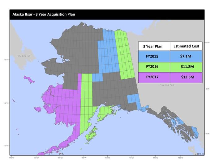
U.S. Geological Survey, Department of the Interior - The annual Alaska IfSAR and DEM acquisition plan is part of the 3DEP initiative to collect high-quality elevation data in the form of interferometric synthetic aperture radar (IfSAR) and light detection and ranging (lidar) data over Alaska. This acquisition plan addresses concerns raised in GAO Report 13-94 regarding geospatial coordination, and supports FGDC data coordination initiatives led by the Department of Interior's Geospatial Information Officer. Mapping a State the size and complexity of Alaska through a partnered effort such as the Alaska Mapping Initiative requires dedicated collaboration and coordination across multiple levels of government. State...
Accurate and consistent estimates of shrubland ecosystem components are crucial to a better understanding of ecosystems condition in arid and semiarid lands. We developed an innovative approach by integrating multiple information to quantify shrubland components as continuous field products within the National Land Cover Database (NLCD). The approach consists of five major parts: field sample collection, high-resolution mapping of shrubland components using WorldView-2 imagery and regression tree models, Landsat 8 radiometric balancing and phenological mosaicking, coarse resolution estimate of shrubland components across a large geographic extent using Landsat 8 phenological mosaics and regression tree models, and...
The Northern Prairie Wildlife Research Center was formally established in 1965 in Jamestown, North Dakota. Over its 50-year history, its scientists have produced more than 1750 publications and reports, covering a wide range of science. This data release is a list of all publications and reports, including journal articles, book and book chapters, government reports, papers from conference proceedings, and reports associated with non-governmental organizations.
Categories: Data;
Types: Citation;
Tags: Aquatic Biology,
Botany,
Climatology,
Ecology,
Hydrogeology,
Groundwater resources are being overexploited in arid and semi-arid environments globally, which necessitates a deeper understanding of the roles that groundwater plays in earth system processes. Of particular importance is the elucidation of groundwater's effect on the generation of atmospheric dust. While many spatially extensive, highly productive dust sources are influenced to some degree by water resource use, including groundwater pumping and other modifications to shallow groundwater tables (<10 m from the surface), links between near-surface groundwater processes and dust production have only recently been identified. Processes associated with shallow groundwater tables include the vertical movement of salts...
Categories: Publication;
Types: Citation,
Journal Citation;
Tags: Journal of Arid Environments,
atmospheric dust,
groundwater,
radionuclides,
remote sensing,
|

|
