Filters: Tags: Reservoirs (X)
372 results (110ms)|
Filters
Date Range
Extensions Types Contacts
Categories Tag Types
|
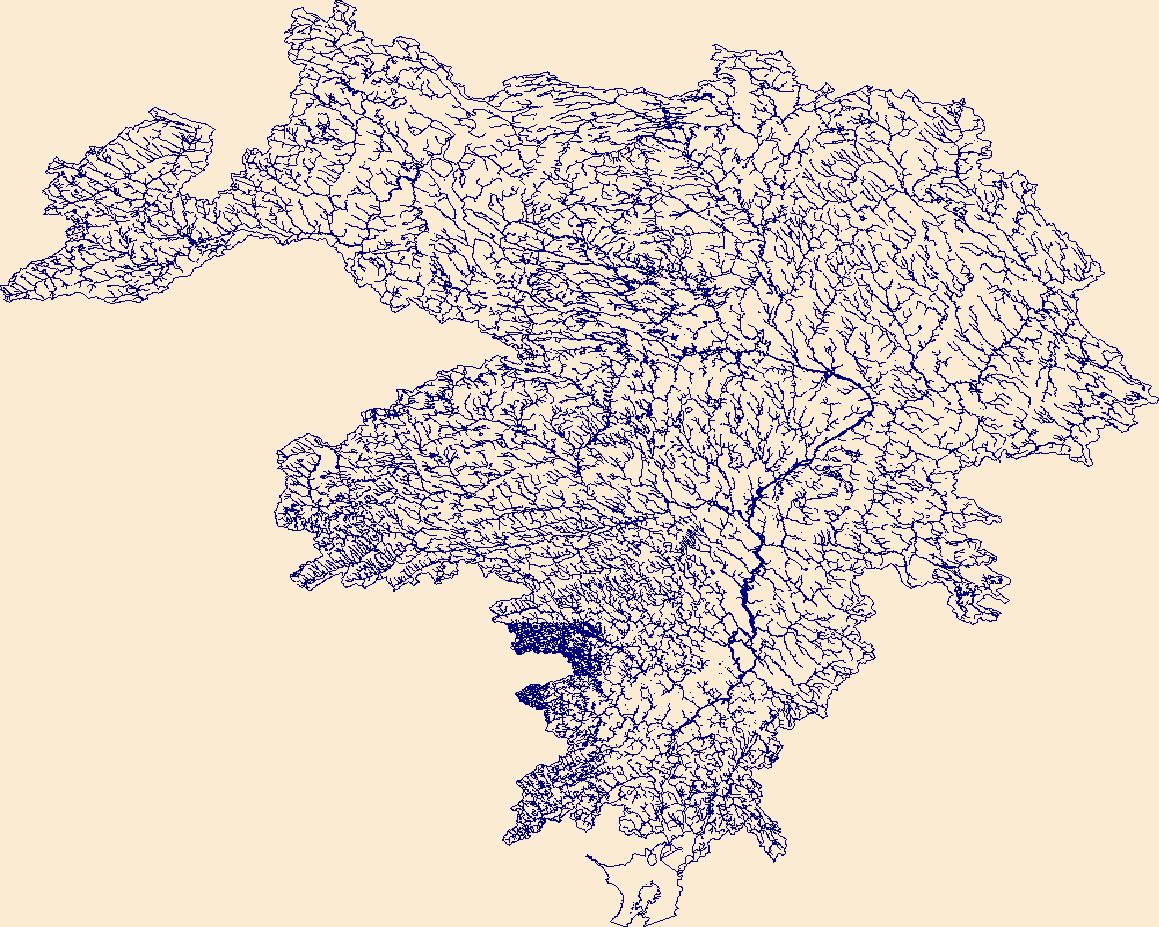
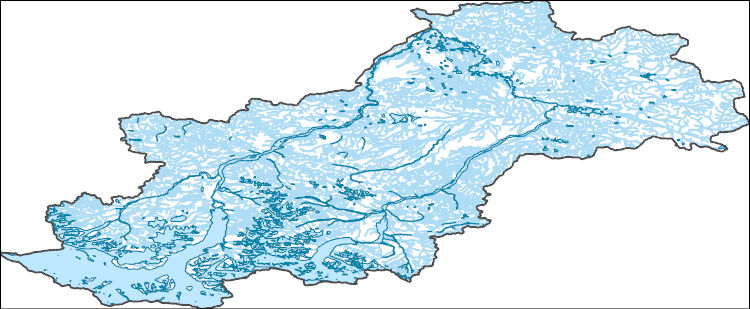
This data release contains information to support water quality modeling in the Delaware River Basin (DRB). These data support both process-based and machine learning approaches to water quality modeling, including the prediction of stream temperature. This section provides spatial data files that describe the rivers, reservoirs, and observational data in the Delaware River Basin included in this release. One shapefile of polylines describes the 459 river reaches that define the modeling network, and another shapefile of polygons includes the three reservoirs (Pepacton, Cannonsville, and Neversink) for which data are included in this release. Additionally, a point shapefile contains locations of monitoring sites...
Categories: Data;
Types: Downloadable,
Map Service,
OGC WFS Layer,
OGC WMS Layer,
OGC WMS Service,
Shapefile;
Tags: DE,
Delaware,
MD,
Maryland,
NJ,
The High Resolution National Hydrography Dataset Plus (NHDPlus HR) is an integrated set of geospatial data layers, including the National Hydrography Dataset (NHD), National Watershed Boundary Dataset (WBD), and 3D Elevation Program Digital Elevation Model (3DEP DEM). The NHDPlus HR combines the NHD, 3DEP DEMs, and WBD to a data suite that includes the NHD stream network with linear referencing functionality, the WBD hydrologic units, elevation-derived catchment areas for each stream segment, "value added attributes" (VAAs), and other features that enhance hydrologic data analysis and routing.
The High Resolution National Hydrography Dataset Plus (NHDPlus HR) is an integrated set of geospatial data layers, including the best available National Hydrography Dataset (NHD), the 10-meter 3D Elevation Program Digital Elevation Model (3DEP DEM), and the National Watershed Boundary Dataset (WBD). The NHDPlus HR combines the NHD, 3DEP DEMs, and WBD to create a stream network with linear referencing, feature naming, "value added attributes" (VAAs), elevation-derived catchments, and other features for hydrologic data analysis. The stream network with linear referencing is a system of data relationships applied to hydrographic systems so that one stream reach "flows" into another and "events" can be tied to and traced...

The High Resolution National Hydrography Dataset Plus (NHDPlus HR) is an integrated set of geospatial data layers, including the best available National Hydrography Dataset (NHD), the 10-meter 3D Elevation Program Digital Elevation Model (3DEP DEM), and the National Watershed Boundary Dataset (WBD). The NHDPlus HR combines the NHD, 3DEP DEMs, and WBD to create a stream network with linear referencing, feature naming, "value added attributes" (VAAs), elevation-derived catchments, and other features for hydrologic data analysis. The stream network with linear referencing is a system of data relationships applied to hydrographic systems so that one stream reach "flows" into another and "events" can be tied to and traced...
Regional transport of water and dissolved constituents through heavily regulated river systems is influenced by the presence of reservoirs. Analysis of seasonal patterns in solute fluxes for salinity and nutrients indicates that in-reservoir processes within large storage reservoirs in the Rio Grande and Colorado basins (southwestern USA) are superimposed over the underlying watershed processes that predominate in relatively unregulated stream reaches. Connectivity of the aquatic system with the landscape is apparently disrupted by processes within the reservoir systems; these processes result in large changes in characteristics for solute transport that persist downstream in the absence of significant inputs. Additionally,...
Categories: Publication;
Types: Citation,
Journal Citation;
Tags: Hydrological Processes,
connectivity,
nutrients,
regulated rivers,
reservoirs,
Predictions are evaluated against observed temperatures.
Multiple modeling frameworks were used to predict daily temperatures at 0.5m depth intervals for a set of diverse lakes in the U.S. states of Minnesota and Wisconsin. General Lake Model verion 2 process-Based (PB) models were configured and calibrated with training data to reduce root-mean squared error for 449 lakes (PBALL). Uncalibrated models used default configurations (PB0; see Winslow et al. 2016 for details) and no parameters were adjusted according to model fit with observations for 7,150 lakes.
Temperate lakes may contain both coolwater fish species such as walleye (Sander vitreus) and warmwater species such as largemouth bass (Micropterus salmoides). Recent declines in walleye and increases in largemouth bass populations have raised questions regarding the future trajectories and appropriate management actions for these important species. We developed a thermodynamic model of water temperatures driven by downscaled climate data and lake specific characteristics to estimate daily water temperature profiles for 2148 lakes in Wisconsin, USA under contemporary (1989-2014) and future (2040-2064 and 2065-2089) conditions. We correlated contemporary walleye recruitment success and largemouth bass relative abundance...
Climate change has been shown to influence lake temperatures globally. To better understand the diversity of lake responses to climate change and give managers tools to manage individual lakes, we modelled daily water temperature profiles for 10,774 lakes in Michigan, Minnesota and Wisconsin for contemporary (1979-2015) and future (2020-2040 and 2080-2100) time periods with climate models based on the Representative Concentration Pathway 8.5, the worst-case emission scenario. From simulated temperatures, we derived commonly used, ecologically relevant annual metrics of thermal conditions for each lake. We included all available supporting metadata including satellite and in-situ observations of water clarity, maximum...
Climate change has been shown to influence lake temperatures in different ways. To better understand the diversity of lake responses to climate change and give managers tools to manage individual lakes, we focused on improving prediction accuracy for daily water temperature profiles in 68 lakes in Minnesota and Wisconsin during 1980-2018. The data are organized into these items: Spatial data - One shapefile of polygons for all 68 lakes in this study (.shp, .shx, .dbf, and .prj files) Model configurations - Model parameters and metadata used to configure models (1 JSON file, with metadata for each of 68 lakes, indexed by "site_id") Model inputs - Data formatted as model inputs for predicting temperature a. Lake...
This dataset includes compiled water temperature data from an instrumented buoy on Lake Mendota, WI and discrete (manually sampled) water temperature records from North Temperate Lakes Long-TERM Ecological Research Program (NTL-LTER; https://lter.limnology.wisc.edu/). The buoy is supported by both the Global Lake Ecological Observatory Network (gleon.org) and the NTL-LTER. This dataset is part of a larger data release of lake temperature model inputs and outputs for 68 lakes in the U.S. states of Minnesota and Wisconsin (http://dx.doi.org/10.5066/P9AQPIVD).
The High Resolution National Hydrography Dataset Plus (NHDPlus HR) is an integrated set of geospatial data layers, including the best available National Hydrography Dataset (NHD), the 10-meter 3D Elevation Program Digital Elevation Model (3DEP DEM), and the National Watershed Boundary Dataset (WBD). The NHDPlus HR combines the NHD, 3DEP DEMs, and WBD to create a stream network with linear referencing, feature naming, "value added attributes" (VAAs), elevation-derived catchments, and other features for hydrologic data analysis. The stream network with linear referencing is a system of data relationships applied to hydrographic systems so that one stream reach "flows" into another and "events" can be tied to and traced...
The High Resolution National Hydrography Dataset Plus (NHDPlus HR) is an integrated set of geospatial data layers, including the best available National Hydrography Dataset (NHD), the 10-meter 3D Elevation Program Digital Elevation Model (3DEP DEM), and the National Watershed Boundary Dataset (WBD). The NHDPlus HR combines the NHD, 3DEP DEMs, and WBD to create a stream network with linear referencing, feature naming, "value added attributes" (VAAs), elevation-derived catchments, and other features for hydrologic data analysis. The stream network with linear referencing is a system of data relationships applied to hydrographic systems so that one stream reach "flows" into another and "events" can be tied to and traced...
The High Resolution National Hydrography Dataset Plus (NHDPlus HR) is an integrated set of geospatial data layers, including the best available National Hydrography Dataset (NHD), the 10-meter 3D Elevation Program Digital Elevation Model (3DEP DEM), and the National Watershed Boundary Dataset (WBD). The NHDPlus HR combines the NHD, 3DEP DEMs, and WBD to create a stream network with linear referencing, feature naming, "value added attributes" (VAAs), elevation-derived catchments, and other features for hydrologic data analysis. The stream network with linear referencing is a system of data relationships applied to hydrographic systems so that one stream reach "flows" into another and "events" can be tied to and traced...

The High Resolution National Hydrography Dataset Plus (NHDPlus HR) is an integrated set of geospatial data layers, including the best available National Hydrography Dataset (NHD), the 10-meter 3D Elevation Program Digital Elevation Model (3DEP DEM), and the National Watershed Boundary Dataset (WBD). The NHDPlus HR combines the NHD, 3DEP DEMs, and WBD to create a stream network with linear referencing, feature naming, "value added attributes" (VAAs), elevation-derived catchments, and other features for hydrologic data analysis. The stream network with linear referencing is a system of data relationships applied to hydrographic systems so that one stream reach "flows" into another and "events" can be tied to and traced...
The U.S. Geological Survey and a consortium of local governments in North Carolina have partnered together to track water quality and quantity conditions in several of the area’s water-supply reservoirs and streams, known as the Triangle Area Water Supply Monitoring Project (TAWSMP). This data release contains the associated data described in the Open-File Report, "Triangle Area Water Supply Monitoring Project, North Carolina-Overview of Hydrologic and Water-Quality Monitoring Activities and Data Quality Assurance". These datasets were collected during October 2019 - September 2022 (Water Years 2020-2022). The data release includes nine items: [Triangle_2020_22_Figure_1.pdf]: This figure shows site locations and...
Categories: Data;
Tags: Chatham County,
Durham County,
North Carolina,
Orange County,
USGS Science Data Catalog (SDC),
This dataset includes model inputs including gridded weather data, a stream network distance matrix, stream reach attributes and metadata, and reservoir characteristics.
Lake temperature is an important environmental metric for understanding habitat suitability for many freshwater species and is especially useful when temperatures are predicted throughout the water column (known as temperature profiles). In this data release, multiple modeling approaches were used to generate predictions of daily temperature profiles for thousands of lakes in the Midwest. Predictions were generated using two modeling frameworks: a machine learning model (specifically an entity-aware long short-term memory or EA-LSTM model; Kratzert et al., 2019) and a process-based model (specifically the General Lake Model or GLM; Hipsey et al., 2019). Both the EA-LSTM and GLM frameworks were used to generate...
This data release contains information to support water quality modeling in the Delaware River Basin (DRB). These data support both process-based and machine learning approaches to water quality modeling, including the prediction of stream temperature. This section includes model drivers such as gridded weather data (NOAA GEFS and GridMET), and the stream network distance matrix for the Delaware River Basin. Additionally, inputs and outputs from an uncalibrated process-based stream temperature model (PRMS-SNTemp) are included.
The High Resolution National Hydrography Dataset Plus (NHDPlus HR) is an integrated set of geospatial data layers, including the best available National Hydrography Dataset (NHD), the 10-meter 3D Elevation Program Digital Elevation Model (3DEP DEM), and the National Watershed Boundary Dataset (WBD). The NHDPlus HR combines the NHD, 3DEP DEMs, and WBD to create a stream network with linear referencing, feature naming, "value added attributes" (VAAs), elevation-derived catchments, and other features for hydrologic data analysis. The stream network with linear referencing is a system of data relationships applied to hydrographic systems so that one stream reach "flows" into another and "events" can be tied to and traced...
|

|
