Filters: Tags: Resource (X) > partyWithName: Conservation Biology Institute (X)
17 results (17ms)|
Filters
Date Range
Tag Schemes |

Annual average offshore wind speed for the Great Lakes (Indiana, Illinois, Michigan, Minnesota, New York, Ohio, Pennsylvania, and Wisconsin) at a 90 meter height. Available from the National Renewable Energy Laboratory (NREL) at http://www.nrel.gov/renewable_resources/. This dataset was last updated on 8/23/2010.

Annual average offshore wind speed for the Pacific Coast (California, Oregon, and Washington) at a 90 meter height. Available from NREL at http://www.nrel.gov/renewable_resources/ . This version was last updated on 8/23/2010.
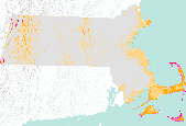
Annual average wind resource potential for the state of Massachusetts at a 50 meter height. Available from the National Renewable Energy Laboratory (NREL) at http://www.nrel.gov/renewable_resources/. This dataset was last updated on 3/2/09.
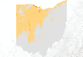
Annual average wind resource potential for the state of Ohio at a 50 meter height. Available from the National Renewable Energy Laboratory (NREL) at http://www.nrel.gov/renewable_resources/ . This dataset was last updated on 3/2/2009.

Annual average wind resource potential for the state of Hawaii at a 50 meter height. Available from the National Renewable Energy Laboratory (NREL) at http://www.nrel.gov/renewable_resources/ . This dataset was last updated on 6/04/2009.

Annual average wind resource potential for the state of Rhode Island at a 50 meter height. Available from the National Renewable Energy Laboratory (NREL) at http://www.nrel.gov/renewable_resources/. This dataset was last updated on 2/20/09.

This GIS polygon shapefile documents additional sensitive resource areas in Northwest Ohio Inland Sensitivity Atlas. These areas are not typically publicly managed or protected as designated areas, and are often remnant native communities and natural habitat areas. Resource experts recommended these sites for atlas inclusion from federal, state, and local public agencies and environmental organizations that reviewed the previous version of the Inland Sensitivity Atlas. Data includes site names, contact entities, resource categories, location descriptions, and emergency and administrative contact information.

Annual average offshore wind speed for the Atlantic Coast (Connecticut, Delaware, Georgia, Massachusetts, Maine, Maryland, New Hampshire, New Jersey, New York, North Carolina, Rhode Island, South Carolina, and Virginia) at a 90 meter height. Available from the National Renewable Energy Laboratory (NREL) at http://www.nrel.gov/renewable_resources/ . This dataset was last updated on 8/23/2010.

Annual average offshore wind speed for the western Gulf of Mexico (Texas and Louisiana) at a 90 meter height. Available from the National Renewable Energy Laboratory (NREL) at http://www.nrel.gov/renewable_resources/ . This dataset was last updated on 8/23/2010.

Annual average wind resource potential for the state of New Hampshire at a 50 meter height. Available from the National Renewable Energy Laboratory (NREL) at http://www.nrel.gov/renewable_resources/. This dataset was last updated on 3/2/09.

Annual average wind resource potential for the state of Arkansas at a 50 meter height. Available from the National Renewable Energy Laboratory (NREL) at http://www.nrel.gov/renewable_resources/ . This dataset was last updated on 3/2/2009.

Annual average offshore wind speed for Hawaii at a 90 meter height. Available from NREL at http://www.nrel.gov/renewable_resources/. This version was last updated on 8/23/2010.

Annual average wind resource potential for the state of Missouri at a 50 meter height. Available from the National Renewable Energy Laboratory (NREL) at http://www.nrel.gov/renewable_resources/ . This dataset was last updated on 3/2/2009.

Annual average wind resource potential for the state of Connecticut at a 50 meter height. Available from the National Renewable Energy Laboratory (NREL) at http://www.nrel.gov/renewable_resources/. This dataset was last updated 3/2/2009.

Annual average wind resource potential for the state of Indiana at a 50 meter height. Available from the National Renewable Energy Laboratory (NREL) at http://www.nrel.gov/renewable_resources/ . This dataset was last updated on 3/2/2009.

Annual average wind resource potential for the state of Nebraska at a 50 meter height. Available from the National Renewable Energy Laboratory (NREL) at http://www.nrel.gov/renewable_resources/ . This dataset was last updated on 2/23/2009.

Annual average wind resource potential for the state of Maine at a 50 meter height. Available from the National Renewable Energy Laboratory (NREL) at http://www.nrel.gov/renewable_resources/. This dataset was last updated on 3/2/2009.
|

|
