Filters
Date Range
Contacts
Tag Types
Tag Schemes
|

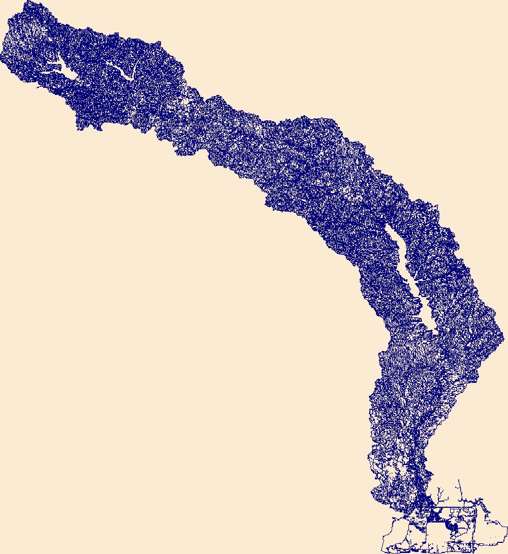
The High Resolution National Hydrography Dataset Plus (NHDPlus HR) is an integrated set of geospatial data layers, including the best available National Hydrography Dataset (NHD), the 10-meter 3D Elevation Program Digital Elevation Model (3DEP DEM), and the National Watershed Boundary Dataset (WBD). The NHDPlus HR combines the NHD, 3DEP DEMs, and WBD to create a stream network with linear referencing, feature naming, "value added attributes" (VAAs), elevation-derived catchments, and other features for hydrologic data analysis. The stream network with linear referencing is a system of data relationships applied to hydrographic systems so that one stream reach "flows" into another and "events" can be tied to and traced...
Tags: AR,
Arkansas,
Atoka County,
Bienville County,
Bossier County, All tags...
Bowie County,
Bryan County,
Caddo County,
Camp County,
Cass County,
Choctaw County,
Claiborne County,
Coal County,
Columbia County,
De Soto County,
Delta County,
Downloadable Data,
Fannin County,
FileGDB,
FileGDB 10.1,
Franklin County,
Grant County,
Grayson County,
Gregg County,
HU-4 Subregion,
HU-4 Subregion,
HU4_1114,
Harrison County,
Hempstead County,
Hopkins County,
Howard County,
Hughes County,
Hunt County,
Hydrography,
Johnston County,
LA,
Lafayette County,
Lamar County,
Latimer County,
Le Flore County,
Lincoln County,
Little River County,
Louisiana,
Marion County,
McCurtain County,
Miller County,
Morris County,
Murray County,
NHDPlus HR Rasters,
NHDPlus High Resolution (NHDPlus HR),
Natchitoches County,
National Hydrography Dataset (NHD),
National Hydrography Dataset Plus High Resolution (NHDPlus HR),
National Hydrography Dataset Plus High Resolution (NHDPlus HR) Current,
Nevada County,
OK,
Oklahoma,
Panola County,
Pike County,
Pittsburg County,
Polk County,
Pontotoc County,
Pushmataha County,
Rapides County,
Red River County,
Red River County,
Sabine County,
Sevier County,
TX,
Texas,
Titus County,
US,
United States,
Upshur County,
Vernon County,
Webster County,
Winn County,
Wood County,
base maps,
cartography,
catchments,
channels,
digital elevation models,
drainage basins,
earth sciences,
elevation,
environment,
geographic information systems,
geoscientific,
geospatial analysis,
hydrographic datasets,
hydrographic features,
hydrology,
imagery,
inland waters,
lakes,
land surface characteristics,
reservoirs,
river reaches,
rivers,
streamflow,
streamflow data,
streams,
topography,
water bodies,
water quality,
water resources,
watersheds, Fewer tags
The High Resolution National Hydrography Dataset Plus (NHDPlus HR) is an integrated set of geospatial data layers, including the best available National Hydrography Dataset (NHD), the 10-meter 3D Elevation Program Digital Elevation Model (3DEP DEM), and the National Watershed Boundary Dataset (WBD). The NHDPlus HR combines the NHD, 3DEP DEMs, and WBD to create a stream network with linear referencing, feature naming, "value added attributes" (VAAs), elevation-derived catchments, and other features for hydrologic data analysis. The stream network with linear referencing is a system of data relationships applied to hydrographic systems so that one stream reach "flows" into another and "events" can be tied to and traced...
Tags: Beauregard County,
Caddo County,
Calcasieu County,
Cameron County,
Collin County, All tags...
De Soto County,
Downloadable Data,
FileGDB,
FileGDB 10.1,
Franklin County,
Gregg County,
HU-4 Subregion,
HU-4 Subregion,
HU4_1201,
Harrison County,
Hopkins County,
Hunt County,
Hydrography,
Jasper County,
Kaufman County,
LA,
Louisiana,
NHDPlus HR Rasters,
NHDPlus High Resolution (NHDPlus HR),
Natchitoches County,
National Hydrography Dataset (NHD),
National Hydrography Dataset Plus High Resolution (NHDPlus HR),
National Hydrography Dataset Plus High Resolution (NHDPlus HR) Current,
Newton County,
Orange County,
Panola County,
Rains County,
Rockwall County,
Rusk County,
Sabine County,
Sabine County,
San Augustine County,
Shelby County,
Smith County,
TX,
Texas,
US,
United States,
Upshur County,
Van Zandt County,
Vernon County,
Wood County,
base maps,
cartography,
catchments,
channels,
digital elevation models,
drainage basins,
earth sciences,
elevation,
environment,
geographic information systems,
geoscientific,
geospatial analysis,
hydrographic datasets,
hydrographic features,
hydrology,
imagery,
inland waters,
lakes,
land surface characteristics,
reservoirs,
river reaches,
rivers,
streamflow,
streamflow data,
streams,
topography,
water bodies,
water quality,
water resources,
watersheds, Fewer tags
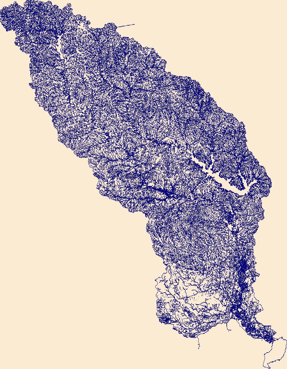
The High Resolution National Hydrography Dataset Plus (NHDPlus HR) is an integrated set of geospatial data layers, including the best available National Hydrography Dataset (NHD), the 10-meter 3D Elevation Program Digital Elevation Model (3DEP DEM), and the National Watershed Boundary Dataset (WBD). The NHDPlus HR combines the NHD, 3DEP DEMs, and WBD to create a stream network with linear referencing, feature naming, "value added attributes" (VAAs), elevation-derived catchments, and other features for hydrologic data analysis. The stream network with linear referencing is a system of data relationships applied to hydrographic systems so that one stream reach "flows" into another and "events" can be tied to and traced...
Tags: Anderson County,
Angelina County,
Cherokee County,
Downloadable Data,
FileGDB, All tags...
FileGDB 10.1,
HU-4 Subregion,
HU-4 Subregion,
HU4_1202,
Hardin County,
Henderson County,
Houston County,
Hydrography,
Jasper County,
Jefferson County,
Liberty County,
NHDPlus HR Rasters,
NHDPlus High Resolution (NHDPlus HR),
Nacogdoches County,
National Hydrography Dataset (NHD),
National Hydrography Dataset Plus High Resolution (NHDPlus HR),
National Hydrography Dataset Plus High Resolution (NHDPlus HR) Current,
Newton County,
Orange County,
Polk County,
Rusk County,
Sabine County,
San Augustine County,
Shelby County,
Smith County,
TX,
Texas,
Trinity County,
Tyler County,
US,
United States,
Van Zandt County,
base maps,
cartography,
catchments,
channels,
digital elevation models,
drainage basins,
earth sciences,
elevation,
environment,
geographic information systems,
geoscientific,
geospatial analysis,
hydrographic datasets,
hydrographic features,
hydrology,
imagery,
inland waters,
lakes,
land surface characteristics,
reservoirs,
river reaches,
rivers,
streamflow,
streamflow data,
streams,
topography,
water bodies,
water quality,
water resources,
watersheds, Fewer tags
|
|

