Filters: Tags: Shaded Relief (X) > partyWithName: U.S. Geological Survey, National Geospatial Technical Operations Center (X)
7 results (73ms)|
Filters
Date Range
Types Contacts Tag Types Tag Schemes |
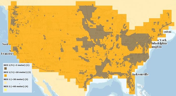
The USGS Elevation Availability service from The National Map (TNM) shows the best available resolution of downloadable elevation data, and is updated approximately every two weeks with National Elevation Dataset (NED) releases. NED 2- (in Alaska only), 1-, and 1/3-arc-second data are staged for download by 1x1 degree tiles in ArcGrid, GridFloat, or IMG formats in The National Map viewer, while NED 1/9 arc-second data is staged by 15x15 minute tiles in IMG format only. For additional information on the NED, go to http://ned.usgs.gov/.
The USGS Topo Large service from The National Map (TNM) is a dynamic topographic base map service that combines the best available data (Boundaries, Elevation, Geographic Names, Hydrography, Land Cover, Structures, Transportation, and other themes) that make up The National Map. Contours generated for the US Topo product are visible along with other data at scales of 1:13,500 and larger. This product is designed to provide a seamless view of the data in a geographic information system (GIS) accessible format, closely resembling The National Map US Topo GeoPDF product at large scales.

The USGS Elevation Availability service from The National Map (TNM) shows the best available resolution of downloadable elevation data, and is updated approximately every weeks with 3D Elevation Program (3DEP) releases. Alaska 2 arc-second, 1 arc-second, and 1/3-arc-second data are staged for download by 1x1 degree tiles in ArcGrid, GridFloat, or IMG formats in The National Map viewer, while 1/9 arc-second data is staged by 15x15 minute tiles in IMG format only. For additional information on the 3D Elevation Program (3DEP), go to https://nationalmap.gov/3DEP/.

U.S. Geological Survey, Department of the Interior - The annual US Topo acquisition plan is to collect topographic map data in the form of US Topo GeoPDF maps over the United States and its territories on a 3-year revision cycle. The FY14 acquisition plan currently anticipates production of 18,500 (or more) US Topo maps this year. Interested parties who wish to become a data acquisition partner with the USGS in FY14 or in future years should contact a USGS Geospatial Liaison - http://liaisons.usgs.gov/geospatial/documents/TNM_Partnership_User_ContactList.pdf.
The USGS Shaded Relief Large service from The National Map (TNM) was created from the National Elevation Dataset (NED), a seamless dataset of best available raster elevation data for the conterminous United States, Alaska, Hawaii, and Territorial Islands of the US. Derived from the NED using a hill shade technique, this base map represents a continental view showing shaded relief from USGS NED layers at resolutions of 1/3-, 1-, and 2-arc-second (in Alaska only). This hillshade is actually five separate shaded relief datasets created from the original terrain data. Each shaded relief has different azimuths and altitude values as follows: 0 45, 135 60, 270 45, 315 45, 45 45. These five datasets are then combined into...

U.S. Geological Survey, Department of the Interior - The annual US Topo acquisition plan is to collect topographic map data in the form of US Topo GeoPDF maps over the United States and its territories on a 3-year revision cycle. The FY17 acquisition plan currently anticipates production of 18,500 (or more) US Topo maps this year. Interested parties who wish to become a data acquisition partner with the USGS in FY17 or in future years should contact a USGS Geospatial Liaison - http://liaisons.usgs.gov/geospatial/documents/TNM_Partnership_User_ContactList.pdf.
The USGS Imagery Topo Large service from The National Map (TNM) is a dynamic topographic base map service that combines the best available data (Boundaries, Elevation, Geographic Names, Hydrography, Land Cover, Structures, and Transportation with Orthoimagery) that make up The National Map. Contours generated for the US Topo product are visible along with other data at scales of 1:13,500 and larger. This product is designed to provide a seamless view of the data in a geographic information system (GIS) accessible format, closely resembling The National Map US Topo GeoPDF product at large scales.
|

|
