Filters: Tags: Sierra Nevada (X)
234 results (10ms)|
Filters
Contacts
(Less)
|

The Nature Conservancy (TNC) has derived climate suitability forecasts for most species of trees and shrubs considered to be ecological dominants of terrestrial Californian habitat types. Our plant projections are compiled as decision support tools to help Conservancy project staff, as well as our external partners, develop the necessary plans, priorities and strategies to successfully adapt to uncertain changes in future climate. In the recently completed Southern Sierra Partnership's 2010 Climate-Adapted Conservation Plan for the Southern Sierra Nevada and Tehachapi Mountains, species and habitat forecasts shown here informed the development of a regional conservation design that explicitly incorporates long-term...
The Nature Conservancy (TNC) has derived climate suitability forecasts for most species of trees and shrubs considered to be ecological dominants of terrestrial Californian habitat types. Our plant projections are compiled as decision support tools to help Conservancy project staff, as well as our external partners, develop the necessary plans, priorities and strategies to successfully adapt to uncertain changes in future climate. In the recently completed Southern Sierra Partnership's 2010 Climate-Adapted Conservation Plan for the Southern Sierra Nevada and Tehachapi Mountains, species and habitat forecasts shown here informed the development of a regional conservation design that explicitly incorporates long-term...

The Nature Conservancy (TNC) has derived climate suitability forecasts for most species of trees and shrubs considered to be ecological dominants of terrestrial Californian habitat types. Our plant projections are compiled as decision support tools to help Conservancy project staff, as well as our external partners, develop the necessary plans, priorities and strategies to successfully adapt to uncertain changes in future climate. In the recently completed Southern Sierra Partnership's 2010 Climate-Adapted Conservation Plan for the Southern Sierra Nevada and Tehachapi Mountains, species and habitat forecasts shown here informed the development of a regional conservation design that explicitly incorporates long-term...
Diurnal cycles of streamflow in snow-fed rivers can be used to infer the average time a water parcel spends in transit from the top of the snowpack to a stream gauge in the river channel. This travel time, which is measured as the difference between the hour of peak snowmelt in the afternoon and the hour of maximum discharge each day, ranges from a few hours to almost a full day later. Travel times increase with longer percolation times through deeper snowpacks, and prior studies of small basins have related the timing of a stream's diurnal peak to the amount of snow stored in a basin. However, in many larger basins the time of peak flow is nearly constant during the first half of the melt season, with little or...
Categories: Publication;
Types: Citation;
Tags: Sierra Nevada,
diurnal cycle,
heterogeneity,
snow,
str

The Nature Conservancy (TNC) has derived climate suitability forecasts for most species of trees and shrubs considered to be ecological dominants of terrestrial Californian habitat types. Our plant projections are compiled as decision support tools to help Conservancy project staff, as well as our external partners, develop the necessary plans, priorities and strategies to successfully adapt to uncertain changes in future climate. In the recently completed Southern Sierra Partnership's 2010 Climate-Adapted Conservation Plan for the Southern Sierra Nevada and Tehachapi Mountains, species and habitat forecasts shown here informed the development of a regional conservation design that explicitly incorporates long-term...
The Nature Conservancy (TNC) has derived climate suitability forecasts for most species of trees and shrubs considered to be ecological dominants of terrestrial Californian habitat types. Our plant projections are compiled as decision support tools to help Conservancy project staff, as well as our external partners, develop the necessary plans, priorities and strategies to successfully adapt to uncertain changes in future climate. In the recently completed Southern Sierra Partnership's 2010 Climate-Adapted Conservation Plan for the Southern Sierra Nevada and Tehachapi Mountains, species and habitat forecasts shown here informed the development of a regional conservation design that explicitly incorporates long-term...
The Nature Conservancy (TNC) has derived climate suitability forecasts for most species of trees and shrubs considered to be ecological dominants of terrestrial Californian habitat types. Our plant projections are compiled as decision support tools to help Conservancy project staff, as well as our external partners, develop the necessary plans, priorities and strategies to successfully adapt to uncertain changes in future climate. In the recently completed Southern Sierra Partnership's 2010 Climate-Adapted Conservation Plan for the Southern Sierra Nevada and Tehachapi Mountains, species and habitat forecasts shown here informed the development of a regional conservation design that explicitly incorporates long-term...

The Nature Conservancy (TNC) has derived climate suitability forecasts for most species of trees and shrubs considered to be ecological dominants of terrestrial Californian habitat types. Our plant projections are compiled as decision support tools to help Conservancy project staff, as well as our external partners, develop the necessary plans, priorities and strategies to successfully adapt to uncertain changes in future climate. In the recently completed Southern Sierra Partnership's 2010 Climate-Adapted Conservation Plan for the Southern Sierra Nevada and Tehachapi Mountains, species and habitat forecasts shown here informed the development of a regional conservation design that explicitly incorporates long-term...

The Nature Conservancy (TNC) has derived climate suitability forecasts for most species of trees and shrubs considered to be ecological dominants of terrestrial Californian habitat types. Our plant projections are compiled as decision support tools to help Conservancy project staff, as well as our external partners, develop the necessary plans, priorities and strategies to successfully adapt to uncertain changes in future climate. In the recently completed Southern Sierra Partnership's 2010 Climate-Adapted Conservation Plan for the Southern Sierra Nevada and Tehachapi Mountains, species and habitat forecasts shown here informed the development of a regional conservation design that explicitly incorporates long-term...

The Nature Conservancy (TNC) has derived climate suitability forecasts for most species of trees and shrubs considered to be ecological dominants of terrestrial Californian habitat types. Our plant projections are compiled as decision support tools to help Conservancy project staff, as well as our external partners, develop the necessary plans, priorities and strategies to successfully adapt to uncertain changes in future climate. In the recently completed Southern Sierra Partnership's 2010 Climate-Adapted Conservation Plan for the Southern Sierra Nevada and Tehachapi Mountains, species and habitat forecasts shown here informed the development of a regional conservation design that explicitly incorporates long-term...
The Nature Conservancy (TNC) has derived climate suitability forecasts for most species of trees and shrubs considered to be ecological dominants of terrestrial Californian habitat types. Our plant projections are compiled as decision support tools to help Conservancy project staff, as well as our external partners, develop the necessary plans, priorities and strategies to successfully adapt to uncertain changes in future climate. In the recently completed Southern Sierra Partnership's 2010 Climate-Adapted Conservation Plan for the Southern Sierra Nevada and Tehachapi Mountains, species and habitat forecasts shown here informed the development of a regional conservation design that explicitly incorporates long-term...
This dataset was used to summarize and analyze the mortality factors recorderd on dead trees in the Sierra Nevada Forest Dynamics Plot Network, which is managed by the Sequoia and Kings Canyon Field station of the U.S. Geological Survey's Western Ecological Research Center. Each row of the dataset represents an individual dead tree. These are dead trees that were recorded in the network from 1998 to 2010 for the subset of plots as described in the associated manuscript; These data support the following: Das, A.J., Stephenson, N.L., Davis, K.P. 2016. Why do trees die? Characterizing the drivers of background tree mortality. Ecology. 97(10): 2616-2627, https://doi.org/10.1002/ecy.1497
Categories: Data;
Types: Map Service,
OGC WFS Layer,
OGC WMS Layer,
OGC WMS Service;
Tags: Sequoia-Kings Canyon National Park,
Sierra Nevada,
USGS Science Data Catalog (SDC),
Yosemite National Park,
bark beetles,
The RCMAP (Rangeland Condition Monitoring Assessment and Projection) dataset quantifies the percent cover of rangeland components across the western U.S. using Landsat imagery from 1985-2021. The RCMAP product suite consists of nine fractional components: annual herbaceous, bare ground, herbaceous, litter, non-sagebrush shrub, perennial herbaceous, sagebrush, shrub, and tree, in addition to the temporal trends of each component. Several enhancements were made to the RCMAP process relative to prior generations. First, we have trained time-series predictions directly from 331 high-resolution sites collected from 2013-2018 from Assessment, Inventory, and Monitoring (AIM) instead of using the 2016 “base” map as an intermediary....
This dataset records mortality-- including involvement of bark beetles-- and burn severity information for trees in long term forest dynamics plots in Sequoia National Park and Yosemite National Park that experienced fire. These data support the following publication: Furniss, T.J., Das, A.J., van Mantgem, P.J., Stephenson, N.L. and Lutz, J.A., 2021. Crowding, climate, and the case for social distancing among trees. Ecological Applications, p.e2507, https://doi.org/10.1002/eap.2507
Categories: Data;
Tags: California,
Forestry,
Sequoia National Park,
Sierra Nevada,
USGS Science Data Catalog (SDC),
Yosemite National Park, California. Glaciated rocks between Mono Pass and Parker Pass in the Sierra Nevada. The direction of ice motion was from right to left. A joint face on the lee side, exposed by the plucking away of a block, remains unscored. 1903.
Categories: Image;
Tags: Mariposa County, California,
National parks,
Sierra Nevada,
Yosemite National Park,
photo print
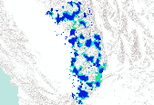
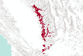
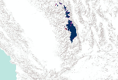
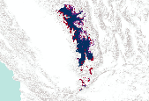
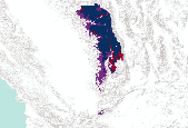
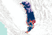
Description: This is the scenario summed solution from the low goals run. This is one of the four scenarios that were combined to form the basis of the regional conservation design. Regional Conservation Design generated by the Southern Sierra Partnership as part of the report ("Framework"): “ Framework for Cooperative Conservation and Climate Adaptation for the Southern Sierra Nevada and Tehachapi Mountains”. See Framework (Section 5.2, Table 7) for low and high goals for vegetation systems, rare plant substrate, etc.
A realistic description of how temperatures vary with elevation is crucial for ecosystem studies and for models of basin-scale snowmelt and spring streamflow. This paper explores surface temperature variability using temperature data from an array of 37 sensors, called the Yosemite network, which traverses both slopes of the Sierra Nevada in the vicinity of Yosemite National Park, California. These data indicate that a simple lapse rate is often a poor description of the spatial temperature structure. Rather, the spatial pattern of temperature over the Yosemite network varies considerably with synoptic conditions. Empirical orthogonal functions (EOFs) were used to identify the dominant spatial temperature patterns...

CDF-FRAP compiled the "best available" land cover data into a single data layer, to support the various analyses required for the 2002 Forest and Range Assessment. Typically the most current and detailed data were collected for various regions of the state or for unique mapping efforts (farmland, wetlands, riparian vegetation). Decision rules were developed that controlled which layers were given priority in areas of overlap. Cross-walks were used to compile the various sources into the common California Wildlife Wabitat Relationships (CWHR) system classification. Data sources had unique scale/resolution, multi-source data provided as 100m GRID. The original 1/2002 data used to support the Asessment is also available...
Tags: landcover,
sierra nevada
The Nature Conservancy (TNC) has derived climate suitability forecasts for most species of trees and shrubs considered to be ecological dominants of terrestrial Californian habitat types. Our plant projections are compiled as decision support tools to help Conservancy project staff, as well as our external partners, develop the necessary plans, priorities and strategies to successfully adapt to uncertain changes in future climate. In the recently completed Southern Sierra Partnership's 2010 Climate-Adapted Conservation Plan for the Southern Sierra Nevada and Tehachapi Mountains, species and habitat forecasts shown here informed the development of a regional conservation design that explicitly incorporates long-term...

The Nature Conservancy (TNC) has derived climate suitability forecasts for most species of trees and shrubs considered to be ecological dominants of terrestrial Californian habitat types. Our plant projections are compiled as decision support tools to help Conservancy project staff, as well as our external partners, develop the necessary plans, priorities and strategies to successfully adapt to uncertain changes in future climate. In the recently completed Southern Sierra Partnership's 2010 Climate-Adapted Conservation Plan for the Southern Sierra Nevada and Tehachapi Mountains, species and habitat forecasts shown here informed the development of a regional conservation design that explicitly incorporates long-term...
|

|
