Filters: Tags: Solar Radiation (X) > partyWithName: U.S. Geological Survey (X)
8 results (45ms)|
Filters
Date Range
Contacts
Categories Tag Types Tag Schemes |
Solar Radiation Index in the Wyoming Basins Ecoregion

These data were released prior to the October 1, 2016 effective date for the USGS’s policy dictating the review, approval, and release of scientific data as referenced in USGS Survey Manual Chapter 502.8 Fundamental Science Practices: Review and Approval of Scientific Data for Release. This spatial data set was created by the U.S. Geological Survey (USGS) to represent mean annual solar radiation in the Pacific Northwest region of the United States (Hydro Region 17; Major River Basin 7 (MRB7)) for the period between 1991 and 2005.
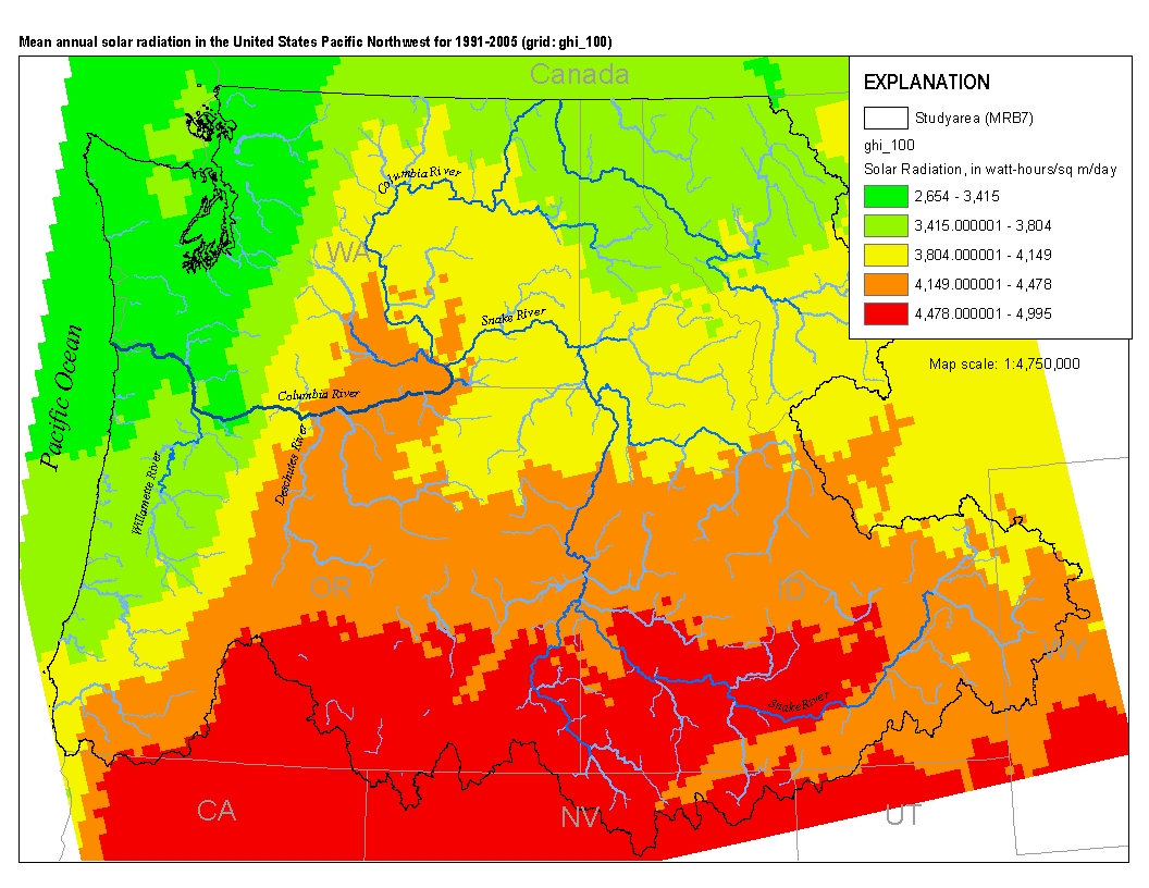
This spatial data set was created by the U.S. Geological Survey (USGS) to represent mean annual solar radiation in the Pacific Northwest region of the United States (Hydro Region 17; Major River Basin 7 (MRB7)) for the period between 1991 and 2005.

Potential evapotranspiration (PET), and reference evapotranspiration (RET) are estimated at an approximately 2-kilometer spatial grid and daily time-scale from January 1, 2018 to December 31, 2018 for the entire State of Florida. Missing values are indicated with -9999.99. Missing values are due to unavailable solar radiation data, derived from the GOES satellite. Potential and reference evapotranspiration were computed on the basis of albedo, solar radiation, and meteorological data observed at weather stations. Solar radiation data obtained from Geostationary Operational Environmental Satellites (GOES) were used to estimate daily PET and RET at grid points. Albedo at grid points was computed on the basis of observations...
These data were compiled from six automated weather stations that together provide several points in the meteorological record across a latitudinal and elevational gradient in southeastern Utah. Recorded data from these weather stations are associated with several different studies. Meteorological data are important for quantifying short term weather events as well as longer term climate trends. Spatially separated precipitation gauges allow for better characterization of the heterogeneity of precipitation events. These data were collected from six locations running from north to south in southeast Utah. All of the weather stations use Campbell Scientific data loggers and data are collected daily via telecommunications...
Categories: Data;
Tags: Canyonlands National Park,
Castle Valley,
Kerby Lane,
La Sal Mountains,
Moab,

These data were released prior to the October 1, 2016 effective date for the USGS’s policy dictating the review, approval, and release of scientific data as referenced in USGS Survey Manual Chapter 502.8 Fundamental Science Practices: Review and Approval of Scientific Data for Release. This spatial data set was created by the U.S. Geological Survey (USGS) to represent mean annual solar radiation in the Pacific Northwest region of the United States (Hydro Region 17; Major River Basin 7 (MRB7)) for the period between 1991 and 2005 within each incremental watershed delineated in the NNHDPlus v2 dataset.
This dataset provides watershed delineations for 1,703 U.S. Geological Survey (USGS) streamgaging stations (gages) for geospatial statistical study of peak streamflows in and near Texas. These streamgaging stations are in Texas, Oklahoma, and New Mexico (east of the Great Continental Divide) with some of the watersheds associated with the 1,703 streamgaging stations extending into several surrounding states or into Mexico. Watershed characteristics are indexed by using the National Hydrography Dataset (NHD) version 2.2.1 Indexing was accomplished by using the Permanent Identifier (PERMID; a string that uniquely identifies each feature in the NHD) and by using the USGS identification number for the streamgaging station...
A 4.5 km resolution raster dataset representing mean Global Horizontal Irradiance (GHI) in kWh (kilowatt-hours) per square-meter per day at each point in the National Solar Radiation Database (NSRDB) from 1998 to 2018 as calculated by Sengupta et al. (2018), and then put into 8 quantile bins for interpretation and reporting. For more information and further data, please visit https://maps.nrel.gov/. Sengupta, M., Xie, Y., Lopez, A., Habte, A., Maclaurin, G., and Shelby, J., 2018, The National Solar Radiation Data Base (NSRDB): Renewable and Sustainable Energy Reviews, v. 89, p. 51-60. https://doi.org/10.1016/j.rser.2018.03.003.
|

|
