Filters: Tags: TNC (X)
37 results (14ms)|
Filters
Date Range
Extensions (Less) Types (Less)
Contacts (Less)
Categories (Less) Tag Types
|

The Rapid Assessment (RA) vegetation dynamics data help to synthesize the best available knowledge of vegetation dynamics and quantify the natural range of variability in vegetation composition and structure. Models consist of two components: (1) a comprehensive description and (2) a quantitative, state-and-transition (box) model, created in the public domain software VDDT (Vegetation Dynamics Development Tool; Beukema et al. 2003). RA vegetation models were based on a simple, standardized five-box model that combines three generic succession stages with two canopy cover classes. Each class is specifically defined for individual models. Variations on this standardized model were also developed. Models were developed...

Conservation Initiative Areas for the Mississippi Chapter of The Nature Conservancy
These data represent a land facet classification created for the Pacific Northwest Duke Landscape Resilience project.
Categories: Data;
Types: Map Service,
OGC WFS Layer,
OGC WMS Layer,
OGC WMS Service;
Tags: ALI,
Arid Lands Initiative,
California,
Data,
EARTH SCIENCE > LAND SURFACE > LANDSCAPE,
The download for this dataset includes TNC’s full Northeastern Aquatic Habitat Classification System: stream size, stream temperature, stream gradient, stream geology, lakes and catchments. This dataset represents the results (9/30/2008) of the Northeastern Aquatic Habitat Classification System (NAHCS) GIS map for streams and rivers. This classification focused on mapping a stream habitat types across 13 northeastern states (ME, NH, VT, MA, CT, RI, NY, NJ, PA, MD, DC, DE, VA, WV). Stream and river centerlines were extracted from the USGS National Hydrography Dataset Plus (NH-Plus) 2006 1:100,000 data. These reaches were attributed and placed into classes representing their biopysical setting in terms of stream...
Categories: Data;
Types: ArcGIS REST Map Service,
ArcGIS Service Definition,
Downloadable,
Map Service;
Tags: Connecticut,
Connecticut,
Data,
Delaware,
Delaware,
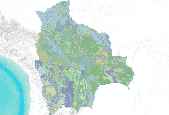
Vegetación de Bolivia 1 : 250 000
This dataset is made up of features aggregated from Ecoregional Assessments as well as other planning methodologies used across The Nature Conservancy to identify areas of biodiversity significance and prioritize conservation action. More information about ecoregional assesments and other conservation planning methodologies is available at The Nature Conservancy's Conservation Gateway, the Ecoregional Assessment Status Tool (EAST), and at http://maps.tnc.org. The BLM has been granted permission from The Nature Conservancy to publish this dataset, which is a snapshot of the Ecoregional Portfolio dataset taken when the REA analysis was completed. Users are encouraged to request the most current dataset directly from...

The Rapid Assessment (RA) vegetation dynamics data help to synthesize the best available knowledge of vegetation dynamics and quantify the natural range of variability in vegetation composition and structure. Models consist of two components: (1) a comprehensive description and (2) a quantitative, state-and-transition (box) model, created in the public domain software VDDT (Vegetation Dynamics Development Tool; Beukema et al. 2003). RA vegetation models were based on a simple, standardized five-box model that combines three generic succession stages with two canopy cover classes. Each class is specifically defined for individual models. Variations on this standardized model were also developed. Models were developed...
Fresh and Saltwater Connectivity This layer was one of the old South Atlantic LCC indicators in the waterscapes ecosystem. It was an index of dams preventing fish migration between rivers and the ocean. Fresh and saltwater connectivity was not performing well as an indicator and could not be used in Blueprint 2.0. This indicator was replaced in Blueprint 2.1 with a new migratory fish connectivity indicator. Reason for Selection Barriers to connectivity between rivers/streams and the ocean can strongly impact diadromous fish and alter natural movement of sediments, are easy to monitor and model, and are widely used and understood by diverse partners. Input Data Southeast Aquatic Connectivity Assessment Project:...
Categories: Data;
Types: ArcGIS REST Map Service,
ArcGIS Service Definition,
Downloadable,
Map Service;
Tags: SARP,
South Atlantic LCC,
TNC,
aquatic connectivity
Bedrock geology strongly influences area soil and water chemistry. Even in glaciated landscapes, studies suggest that soil parent material is commonly of local origin, rarely being ice-transported more that a few miles from its source. Bedrock types also differ in how they weather and in the physical characteristics of the residual soil type. Because of this, local lithology is usually the principle determinant of soil chemistry, texture, and nutrient availability. Many ecological community types are closely related to the chemistry and drainage of the soils or are associated with particular bedrock exposures. We grouped bedrock units on the bedrock geology maps of ME, NH, VT, MA, CT, RI, NY, PA, NJ, and MD into...
Categories: Data;
Types: ArcGIS REST Map Service,
ArcGIS Service Definition,
Downloadable,
Map Service;
Tags: Geology,
TNC,
Terrestrial,
bedrock geology
A "landform" is any physical, recognizable form or feature on the earth's surface that has a characteristic shape and that is produced by natural causes (USDA Natural Resources Conservation Service). Landforms are largely responsible for local variation in solar radiation, soil development, moisture availability, and susceptibility to wind and other disturbance. They therefore have a large influence on plant productivity and species distributions. This dataset maps 17 landforms that are commonly found in the Northeastern U.S. and eastern Canada. This dataset was developed by The Nature Conservancy as part of "Resilient Sites for Terrestrial Conservation in the Northeast and Mid-Atlantic region" found here: http://www.conservationgateway.org/ConservationByGeography/NorthAmerica/U...
Categories: Data;
Types: ArcGIS REST Map Service,
ArcGIS Service Definition,
Downloadable,
Map Service;
Tags: Ecoregional planning,
Landforms,
TNC,
Terrestrial

This database is a compilation database of all available land trust and TNC conservation data
Categories: Data;
Types: Downloadable;
Tags: Areas,
Conservation,
Easements,
Land Trust,
Preservation,
This map depicts the density of "More Resilient" cells (defined as the top two quintiles from the stratified resilience dataset) within a 3-km radius of every cell. This provides important additional context when making land protection or restoration decisions. Cells with higher density values are embedded in a larger resilient landscape. These areas are more likely to support biodiversity and ecological function over time in a changing climate. To quantify resilience at the landscape scale, we used a density function, where all cells classified in the final top two resilience quintiles were included in the density calculations, regardless of their underlying Ecofacet, and all other cells were ignored. Looking...
(This dataset displays the land facet elevation class) Land facets are a primary component in TNC’s analysis of site resilience to climate change. Their inclusion is based on the assumption that preservation of representative examples of the geophysical ‘Stage’ (ie., topo-edaphic factors) results in protection of a wider variety of species (the ‘Players’). These data represent a land facet classification created for the Pacific Northwest Landscape Resilience project. Each Land Facet has been stratified by terrestrial ecoregions - essentially defining each combination of soil order, elevation zone and slope class as unique from that same combination in another ecoregion. A full description of the development of...
Categories: Data;
Types: ArcGIS REST Map Service,
ArcGIS Service Definition,
Downloadable,
Map Service;
Tags: Idaho,
Land facets,
NPLCC,
climate change,
ddcf,

Global Ecoregions, Major Habitat Types, Biogeographical Realms and The Nature Conservancy Terrestrial Assessment Units as of December 14, 2009
The download for this dataset includes the full Northeastern Aquatic Habitat Classification System (NAHCS): stream size, stream temperature, stream gradient, stream geology, lakes, and catchments. This dataset represents the results (9/30/2008) of the Northeastern Aquatic Habitat Classification System (NAHCS) GIS map for streams and rivers. This classification focused on mapping a stream habitat types across 13 northeastern states (ME, NH, VT, MA, CT, RI, NY, NJ, PA, MD, DC, DE, VA, WV). Stream and river centerlines were extracted from the USGS National Hydrography Dataset Plus (NH-Plus) 2006 1:100,000 data. These reaches were attributed and placed into classes representing their biopysical setting in terms of...
Categories: Data;
Types: ArcGIS REST Map Service,
ArcGIS Service Definition,
Downloadable,
Map Service;
Tags: Connecticut,
Connecticut,
Data,
Delaware,
Delaware,
A spatial dataset of public and private lands and waters secured by a conservation situation that includes an explicit level of security from future conversion and current incompatible uses.For more information on TNC's Secured Lands project visit: www.conservationgateway.org/ConservationByGeography/NorthAmerica/UnitedStates/edc/reportsdata/terrestrial/secured/Pages/default.aspx The list of sources for this dataset can be found in the attached word document. The full report on the status and condition of the northeastern natural landscapes, under all levels of protection: https://www.conservationgateway.org/ConservationByGeography/NorthAmerica/UnitedStates/edc/Documents/Conservation-Status-of-Fish-Wildlife-and-Natural-Habitats.pdf...
Categories: Data,
Publication;
Types: ArcGIS REST Map Service,
ArcGIS Service Definition,
Citation,
Downloadable,
Map Service;
Tags: TNC,
areas,
easements,
gap,
land,
A spatial dataset of public and private lands and waters secured by a conservation situation that includes an explicit level of security from future conversion and current incompatible uses.For more information on TNC's Secured Lands project visit: www.conservationgateway.org/ConservationByGeography/NorthAmerica/UnitedStates/edc/reportsdata/terrestrial/secured/Pages/default.aspx The list of sources for this dataset can be found in the attached word document. The full report on the status and condition of the northeastern natural landscapes, under all levels of protection: https://www.conservationgateway.org/ConservationByGeography/NorthAmerica/UnitedStates/edc/Documents/Conservation-Status-of-Fish-Wildlife-and-Natural-Habitats.pdf...
Categories: Data;
Types: ArcGIS REST Map Service,
ArcGIS Service Definition,
Downloadable,
Map Service;
Tags: TNC,
conservation,
secured lands,
terrestrial
The objective of this classification was to create a simplified set of stream and river habitat types based on the Northeast Aquatic Habitat Classification System (Olivero and Anderson 2008) and GIS map for 13 northeastern states (ME, NH, VT, MA, RI, CT, NY, PA, NJ, DE, MD, VA, WV, and DC.) that could be used in the Northeast Stream and River Habitat Guide (available at http://nature.ly/HabGuide). The goal was to collapse the existing 258 types down to ~25 types for reporting in the habitat guide. The habitat guide contains a description of each stream and river type, a distribution map, a photo, associated common and rare species, a crosswalk to state aquatic community types, and a summary of current condition...

The Rapid Assessment (RA) vegetation dynamics data help to synthesize the best available knowledge of vegetation dynamics and quantify the natural range of variability in vegetation composition and structure. Models consist of two components: (1) a comprehensive description and (2) a quantitative, state-and-transition (box) model, created in the public domain software VDDT (Vegetation Dynamics Development Tool; Beukema et al. 2003). RA vegetation models were based on a simple, standardized five-box model that combines three generic succession stages with two canopy cover classes. Each class is specifically defined for individual models. Variations on this standardized model were also developed. Models were developed...

Ecological Drainage Units (EDUs) group watersheds that share a common zoogeographic history, physiographic and climatic characteristics, and therefore likely have a distinct set of freshwater assemblages and habitats. EDUs are hypothesized to account for the variability within fish zoogeographic sub-regions due to finer-scale drainage basin boundaries and physiography. EDUs are delineated as groups of 8-digit US Geological Survey Hydrologic Unit watersheds. EDUS were qualitatively defined by the TNC Freshwater Initiative using primarily USFS Fish Zoogeographic Subregions, USFS Ecoregions and Subsections, and major drainage divisions.
|

|
