Filters: Tags: Yukon (X)
155 results (82ms)|
Filters
Date Range
Extensions Types
Contacts
Categories Tag Types
|
Marine Arctic polygon distribution of Marbled Eelpout (Lycodes raridens) Taranetz & Andriashev, 1937
Region(s) of distribution of Marbled Eelpout (Lycodes raridens) Taranetz & Andriashev, 1937 in the Arctic as digitized for U.S. Geological Survey Scientific Investigations Report 2016-5038. For details on the project and purpose, see the report at https://doi.org/10.3133/sir20165038. Complete metadata for the collection of species datasets is in the metadata document "Dataset_for_Alaska_Marine_Fish_Ecology_Catalog.xml" at https://doi.org/10.5066/F7M61HD7. Source(s) for this digitized data layer are listed in the metadata Process Steps section. Note that the original source may show an extended area; some datasets were limited to the published map boundary. Distributions of marine fishes are shown in adjacent Arctic...
Categories: Data;
Types: Citation,
Downloadable,
Map Service,
OGC WFS Layer,
OGC WMS Layer,
Shapefile;
Tags: Alaska,
Arctic,
Arctic,
Beaufort Sea,
Bering Sea,
Region(s) of distribution of Alaska Plaice (Pleuronectes quadrituberculatus) Pallas, 1814 in the Arctic as digitized for U.S. Geological Survey Scientific Investigations Report 2016-5038. For details on the project and purpose, see the report at https://doi.org/10.3133/sir20165038. Complete metadata for the collection of species datasets is in the metadata document "Dataset_for_Alaska_Marine_Fish_Ecology_Catalog.xml" at https://doi.org/10.5066/F7M61HD7. Source(s) for this digitized data layer are listed in the metadata Process Steps section. Note that the original source may show an extended area; some datasets were limited to the published map boundary. Distributions of marine fishes are shown in adjacent Arctic...
Categories: Data;
Types: Citation,
Downloadable,
Map Service,
OGC WFS Layer,
OGC WMS Layer,
Shapefile;
Tags: Alaska,
Alaska Plaice,
Arctic,
Arctic,
Beaufort Sea,
Region(s) of distribution of Glacier Lanternfish (Benthosema glaciale) (Reinhardt, 1837) in the Arctic as digitized for U.S. Geological Survey Scientific Investigations Report 2016-5038. For details on the project and purpose, see the report at https://doi.org/10.3133/sir20165038. Complete metadata for the collection of species datasets is in the metadata document "Dataset_for_Alaska_Marine_Fish_Ecology_Catalog.xml" at https://doi.org/10.5066/F7M61HD7. Source(s) for this digitized data layer are listed in the metadata Process Steps section. Note that the original source may show an extended area; some datasets were limited to the published map boundary. Distributions of marine fishes are shown in adjacent Arctic...
Categories: Data;
Types: Citation,
Downloadable,
Map Service,
OGC WFS Layer,
OGC WMS Layer,
Shapefile;
Tags: (Reinhardt, 1837),
Alaska,
Arctic,
Arctic,
Beaufort Sea,
Region(s) of distribution of Crested Sculpin (Blepsias bilobus) Cuvier, 1829 in the Arctic as digitized for U.S. Geological Survey Scientific Investigations Report 2016-5038. For details on the project and purpose, see the report at https://doi.org/10.3133/sir20165038. Complete metadata for the collection of species datasets is in the metadata document "Dataset_for_Alaska_Marine_Fish_Ecology_Catalog.xml" at https://doi.org/10.5066/F7M61HD7. Source(s) for this digitized data layer are listed in the metadata Process Steps section. Note that the original source may show an extended area; some datasets were limited to the published map boundary. Distributions of marine fishes are shown in adjacent Arctic seas where...
Categories: Data;
Types: Citation,
Downloadable,
Map Service,
OGC WFS Layer,
OGC WMS Layer,
Shapefile;
Tags: Alaska,
Arctic,
Arctic,
Beaufort Sea,
Bering Sea,
Region(s) of distribution of Pacific Lamprey (Entosphenus tridentatus) (Gairdner, 1836) in the Arctic as digitized for U.S. Geological Survey Scientific Investigations Report 2016-5038. For details on the project and purpose, see the report at https://doi.org/10.3133/sir20165038. Complete metadata for the collection of species datasets is in the metadata document "Dataset_for_Alaska_Marine_Fish_Ecology_Catalog.xml" at https://doi.org/10.5066/F7M61HD7. Source(s) for this digitized data layer are listed in the metadata Process Steps section. Note that the original source may show an extended area; some datasets were limited to the published map boundary. Distributions of marine fishes are shown in adjacent Arctic...
Categories: Data;
Types: Citation,
Downloadable,
Map Service,
OGC WFS Layer,
OGC WMS Layer,
Shapefile;
Tags: (Gairdner, 1836),
Alaska,
Arctic,
Arctic,
Beaufort Sea,
Region(s) of distribution of Arctic Eelpout (Lycodes reticulatus) Reinhardt, 1835 in the Arctic as digitized for U.S. Geological Survey Scientific Investigations Report 2016-5038. For details on the project and purpose, see the report at https://doi.org/10.3133/sir20165038. Complete metadata for the collection of species datasets is in the metadata document "Dataset_for_Alaska_Marine_Fish_Ecology_Catalog.xml" at https://doi.org/10.5066/F7M61HD7. Source(s) for this digitized data layer are listed in the metadata Process Steps section. Note that the original source may show an extended area; some datasets were limited to the published map boundary. Distributions of marine fishes are shown in adjacent Arctic seas where...
Categories: Data;
Types: Citation,
Downloadable,
Map Service,
OGC WFS Layer,
OGC WMS Layer,
Shapefile;
Tags: Alaska,
Arctic,
Arctic,
Arctic Eelpout,
Beaufort Sea,
Region(s) of distribution of Scalebelly Eelpout (Lycodes squamiventer) Jensen, 1904 in the Arctic as digitized for U.S. Geological Survey Scientific Investigations Report 2016-5038. For details on the project and purpose, see the report at https://doi.org/10.3133/sir20165038. Complete metadata for the collection of species datasets is in the metadata document "Dataset_for_Alaska_Marine_Fish_Ecology_Catalog.xml" at https://doi.org/10.5066/F7M61HD7. Source(s) for this digitized data layer are listed in the metadata Process Steps section. Note that the original source may show an extended area; some datasets were limited to the published map boundary. Distributions of marine fishes are shown in adjacent Arctic seas...
Categories: Data;
Types: Citation,
Downloadable,
Map Service,
OGC WFS Layer,
OGC WMS Layer,
Shapefile;
Tags: Alaska,
Arctic,
Arctic,
Beaufort Sea,
Bering Sea,
Categories: Data,
Publication;
Types: Citation,
Downloadable,
Map Service,
OGC WFS Layer,
OGC WMS Layer,
Shapefile;
Tags: Bluefish River,
Driftwood River,
Fishing Branch River,
M1-Fish,
Miner River,
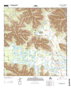
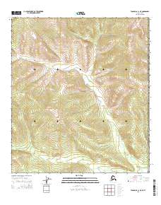
Layered GeoPDF Quadrangle Map. Layers of geospatial data include orthoimagery, roads, grids, geographic names, elevation contours, hydrography, and other selected map features.
Region(s) of distribution of Ice Cod (Arctogadus glacialis) (Peters, 1872) in the Arctic as digitized for U.S. Geological Survey Scientific Investigations Report 2016-5038. For details on the project and purpose, see the report at https://doi.org/10.3133/sir20165038. Complete metadata for the collection of species datasets is in the metadata document "Dataset_for_Alaska_Marine_Fish_Ecology_Catalog.xml" at https://doi.org/10.5066/F7M61HD7. Source(s) for this digitized data layer are listed in the metadata Process Steps section. Note that the original source may show an extended area; some datasets were limited to the published map boundary. Distributions of marine fishes are shown in adjacent Arctic seas where reliable...
Categories: Data;
Types: Citation,
Downloadable,
Map Service,
OGC WFS Layer,
OGC WMS Layer,
Shapefile;
Tags: (Peters, 1872),
Alaska,
Arctic,
Arctic,
Arctogadus glacialis,
Region(s) of distribution of Leatherfin Lumpsucker (Eumicrotremus derjugini) Popov, 1926 in the Arctic as digitized for U.S. Geological Survey Scientific Investigations Report 2016-5038. For details on the project and purpose, see the report at https://doi.org/10.3133/sir20165038. Complete metadata for the collection of species datasets is in the metadata document "Dataset_for_Alaska_Marine_Fish_Ecology_Catalog.xml" at https://doi.org/10.5066/F7M61HD7. Source(s) for this digitized data layer are listed in the metadata Process Steps section. Note that the original source may show an extended area; some datasets were limited to the published map boundary. Distributions of marine fishes are shown in adjacent Arctic...
Categories: Data;
Types: Citation,
Downloadable,
Map Service,
OGC WFS Layer,
OGC WMS Layer,
Shapefile;
Tags: Alaska,
Arctic,
Arctic,
Beaufort Sea,
Bering Sea,
Region(s) of distribution of Polar Sculpin (Cottunculus microps) Collett, 1875 in the Arctic as digitized for U.S. Geological Survey Scientific Investigations Report 2016-5038. For details on the project and purpose, see the report at https://doi.org/10.3133/sir20165038. Complete metadata for the collection of species datasets is in the metadata document "Dataset_for_Alaska_Marine_Fish_Ecology_Catalog.xml" at https://doi.org/10.5066/F7M61HD7. Source(s) for this digitized data layer are listed in the metadata Process Steps section. Note that the original source may show an extended area; some datasets were limited to the published map boundary. Distributions of marine fishes are shown in adjacent Arctic seas where...
Categories: Data;
Types: Citation,
Downloadable,
Map Service,
OGC WFS Layer,
OGC WMS Layer,
Shapefile;
Tags: Alaska,
Arctic,
Arctic,
Beaufort Sea,
Bering Sea,
Region(s) of distribution of Wattled Eelpout (Lycodes palearis) Gilbert, 1896 in the Arctic as digitized for U.S. Geological Survey Scientific Investigations Report 2016-5038. For details on the project and purpose, see the report at https://doi.org/10.3133/sir20165038. Complete metadata for the collection of species datasets is in the metadata document "Dataset_for_Alaska_Marine_Fish_Ecology_Catalog.xml" at https://doi.org/10.5066/F7M61HD7. Source(s) for this digitized data layer are listed in the metadata Process Steps section. Note that the original source may show an extended area; some datasets were limited to the published map boundary. Distributions of marine fishes are shown in adjacent Arctic seas where...
Categories: Data;
Types: Citation,
Downloadable,
Map Service,
OGC WFS Layer,
OGC WMS Layer,
Shapefile;
Tags: Alaska,
Arctic,
Arctic,
Beaufort Sea,
Bering Sea,
Region(s) of distribution of Arctic Sculpin (Myoxocephalus scorpioides) (Fabricius, 1780) in the Arctic as digitized for U.S. Geological Survey Scientific Investigations Report 2016-5038. For details on the project and purpose, see the report at https://doi.org/10.3133/sir20165038. Complete metadata for the collection of species datasets is in the metadata document "Dataset_for_Alaska_Marine_Fish_Ecology_Catalog.xml" at https://doi.org/10.5066/F7M61HD7. Source(s) for this digitized data layer are listed in the metadata Process Steps section. Note that the original source may show an extended area; some datasets were limited to the published map boundary. Distributions of marine fishes are shown in adjacent Arctic...
Categories: Data;
Types: Citation,
Downloadable,
Map Service,
OGC WFS Layer,
OGC WMS Layer,
Shapefile;
Tags: (Fabricius, 1780),
Alaska,
Arctic,
Arctic,
Arctic Sculpin,
Region(s) of distribution of Slender Eelblenny (Lumpenus fabricii) Reinhardt, 1836 in the Arctic as digitized for U.S. Geological Survey Scientific Investigations Report 2016-5038. For details on the project and purpose, see the report at https://doi.org/10.3133/sir20165038. Complete metadata for the collection of species datasets is in the metadata document "Dataset_for_Alaska_Marine_Fish_Ecology_Catalog.xml" at https://doi.org/10.5066/F7M61HD7. Source(s) for this digitized data layer are listed in the metadata Process Steps section. Note that the original source may show an extended area; some datasets were limited to the published map boundary. Distributions of marine fishes are shown in adjacent Arctic seas...
Categories: Data;
Types: Citation,
Downloadable,
Map Service,
OGC WFS Layer,
OGC WMS Layer,
Shapefile;
Tags: Alaska,
Arctic,
Arctic,
Beaufort Sea,
Bering Sea,
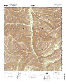
Layered GeoPDF Quadrangle Map. Layers of geospatial data include orthoimagery, roads, grids, geographic names, elevation contours, hydrography, and other selected map features.
Layered GeoPDF Quadrangle Map. Layers of geospatial data include orthoimagery, roads, grids, geographic names, elevation contours, hydrography, and other selected map features.
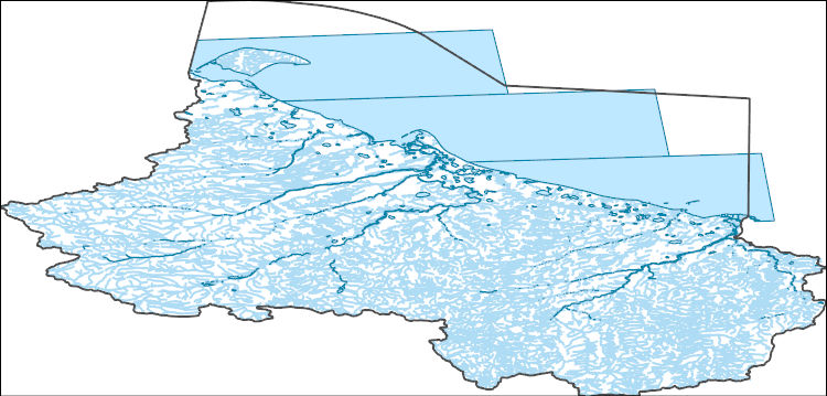
The National Hydrography Dataset (NHD) is a feature-based database that interconnects and uniquely identifies the stream segments or reaches that make up the nation's surface water drainage system. NHD data was originally developed at 1:100,000-scale and exists at that scale for the whole country. This high-resolution NHD, generally developed at 1:24,000/1:12,000 scale, adds detail to the original 1:100,000-scale NHD. (Data for Alaska, Puerto Rico and the Virgin Islands was developed at high-resolution, not 1:100,000 scale.) Local resolution NHD is being developed where partners and data exist. The NHD contains reach codes for networked features, flow direction, names, and centerline representations for areal water...
Categories: Data,
Publication;
Types: Citation,
Downloadable,
Map Service,
OGC WFS Layer,
OGC WMS Layer,
Shapefile;
Tags: B5-Fish,
Bluefish River,
Northern Porcupine Watershed,
Yukon
Region(s) of distribution of White Sea Eelpout (Lycodes marisalbi) Knipowitsch, 1906 in the Arctic as digitized for U.S. Geological Survey Scientific Investigations Report 2016-5038. For details on the project and purpose, see the report at https://doi.org/10.3133/sir20165038. Complete metadata for the collection of species datasets is in the metadata document "Dataset_for_Alaska_Marine_Fish_Ecology_Catalog.xml" at https://doi.org/10.5066/F7M61HD7. Source(s) for this digitized data layer are listed in the metadata Process Steps section. Note that the original source may show an extended area; some datasets were limited to the published map boundary. Distributions of marine fishes are shown in adjacent Arctic seas...
Categories: Data;
Types: Citation,
Downloadable,
Map Service,
OGC WFS Layer,
OGC WMS Layer,
Shapefile;
Tags: Alaska,
Arctic,
Arctic,
Beaufort Sea,
Bering Sea,
|

|
