Filters: Tags: amphibian (X)
82 results (76ms)|
Filters
Contacts
(Less)
|
(i) This dataset presents macroscopic and microscopic pathological findings and bacteriology of 178 tadpoles diagnosed with Severe Perkinsea Infections. (ii) Specimen were collected and submitted to the NWHC as part of mortality investigations and collection of specimen from apparently healthy populations as part of ongoing amphibian health monitoring. (iii) Necropsies and gross evaluation of carcasses were carried out under a dissecting microscope. (iv) Severe Perkinsea Infection was confirmed in each specimen by histological observation of pathological changes in tissues with presence of Perkinsea-like organisms in at least one organ, including brain, eyes, gastrointestinal tract, gills, heart, liver, lungs, kidney,...
Categories: Data;
Types: Map Service,
OGC WFS Layer,
OGC WMS Layer,
OGC WMS Service;
Tags: USGS Science Data Catalog (SDC),
Unites States of Ameica,
amphibian,
biota,
case definition,
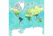
Number of amphibian species, by freshwater ecoregion. We calculated the number of amphibian species per freshwater ecoregion using species range maps of the Global Amphibian Assessment (GAA, www.iucnredlist.org/amphibians) (IUCN et al. 2006). The 2006 GAA assessed 5,918 amphibian species and provided distribution maps for 5,640 of those species. When a range overlapped several ecoregions, we counted species as present in all those ecoregions that had part of the range. This may have resulted in an overestimate of species numbers in some ecoregions, especially those that are long and narrow in shape. This is particularly true for the Amazonas High Andes ecoregion (312), where the mountain range has been used as...
Some of the SNK rasters intentionally do not align or have the same extent. These rasters were not snapped to a common raster per the authors' discretion. Please review selected rasters prior to use. These varying alignments are a result of the use of differing source data sets and all products derived from them. We recommend that users snap or align rasters as best suits their own projects. - This dataset consists of raster distribution maps for terrestrial vertebrate species in Alaska. Individual species distribution maps were developed using the best available known occurrence points for each species and modeled using MaxEnt software and a series of environmental predictor variables. Output maps were clipped...
The Virginia Department of Conservation and Recreation – Natural Heritage Program (DCRDNH) and the Florida Natural Areas Inventory (FNAI) at Florida State University (collectively, Project Partners) were funded by the South Atlantic Landscape Conservation Cooperative (SALCC) in April 2015 to develop ten species distribution models (SDM) of priority at-risk and range-restricted species (Ambystoma cingulatum, Echinacea laevigata, Heterodon simus, Lindera melissifolia, Lythrum curtissii, Notophthalmus perstriatus, Phemeranthus piedmontanus, Rhus michauxii, and Schwalbea americana) for the purposes of incorporating the models and supporting information on the conservation and management needs of the species into the...
The Virginia Department of Conservation and Recreation – Natural Heritage Program (DCRDNH) and the Florida Natural Areas Inventory (FNAI) at Florida State University (collectively, Project Partners) were funded by the South Atlantic Landscape Conservation Cooperative (SALCC) in April 2015 to develop ten species distribution models (SDM) of priority at-risk and range-restricted species (Ambystoma cingulatum, Echinacea laevigata, Heterodon simus, Lindera melissifolia, Lythrum curtissii, Notophthalmus perstriatus, Phemeranthus piedmontanus, Rhus michauxii, and Schwalbea americana) for the purposes of incorporating the models and supporting information on the conservation and management needs of the species into the...
GIS layers depicting South Atlantic Priority Amphibian and Reptile Conservation Areas (PARCAs)
What are current conditions for important park natural resources? What are the critical data and knowledge gaps? What are some of the factors that are influencing park resource conditions? Natural Resource Condition Assessments (NRCAs) evaluate and report on the above for a subset of important natural resources in national park units (hereafter, parks). Focal study resources and indicators are selected on a park-by-park basis, guided by use of structured resource assessment and reporting frameworks. Considerations include park resource setting and enabling legislation (what are this park's most important natural resources?) and presently available data and expertise (what can be evaluated at this time?). In addition...
Categories: Data;
Types: ArcGIS REST Map Service,
Map Service,
OGC WFS Layer,
OGC WMS Layer,
OGC WMS Service;
Tags: Chihuahuan Desert,
English,
GIS,
Madrean,
Mojave Desert,
Welcome to the Wind and Wildlife Landscape Assessment Tool (LAT), a collaboration organized by the American Wind Wildlife Institute (AWWI) and The Nature Conservancy (TNC). The LAT is designed as a landscape-level planning tool to identify sensitive wildlife habitat and areas that are likely to have low wildlife risk where wind energy development could be prioritized. Although the siting of individual wind energy projects will require on-the-ground surveys to verify data shown here, our hope is that this tool will provide stakeholders with information that facilitates the siting of wind energy in areas with minimal impacts to wildlife, as well as the development of conservation plans, monitoring plans and mitigation...
Types: Map Service,
OGC WFS Layer,
OGC WMS Layer,
OGC WMS Service;
Tags: English,
GIS,
US,
agriculture,
amphibian,
The Coordinating Institution for the Species and Specimens Thematic Network is a Consortium leads by "Instituto Nacional de Biodiversidad, INBio of Costa Rica" . The members of the consortrium are: Instituto Nacional de Biodiversidad, INBio (Costa Rica) Instituto de Investigación de Recursos Biológicos Alexander von Humboldt (Colombia) (Colombia) Museo Argentino de Ciencias Naturales (Argentina) Red de Herbarios de Centroamérica y el Caribe Natureserve (USA) The goal is to implement an electronic and institutional network dedicated to regional specimen information. Some of the specimen data of any given country resides in its own museums and herbariums, although a significant part of the data resides in museums...
Types: Map Service,
OGC WFS Layer,
OGC WMS Layer,
OGC WMS Service;
Tags: GIS,
Mexico,
amphibian,
bird,
fish,
WHISPers stands for Wildlife Health Information Sharing Partnership - event reporting system. It is a web-based repository for sharing basic information about historic and ongoing wildlife mortality (death) and morbidity (illness) events. The system possesses a searchable archive of wildlife mortality and morbidity event data that is available to the public. The information is opportunistically collected and does not reflect all the mortality events that occur in North America.
Some of the SNK rasters intentionally do not align or have the same extent. These rasters were not snapped to a common raster per the authors' discretion. Please review selected rasters prior to use. These varying alignments are a result of the use of differing source data sets and all products derived from them. We recommend that users snap or align rasters as best suits their own projects. - This dataset consists of raster distribution maps for terrestrial vertebrate species in Alaska. Individual species distribution maps were developed using the best available known occurrence points for each species and modeled using MaxEnt software and a series of environmental predictor variables. Output maps were clipped...
Observations (reduced to detected/not detected) of 45 vertebrate species (seven mammals, seven amphibians, and 31 reptiles) across Southern California pitfall sampling projects conducted between 1995 through 2015. Habitat patch locations of every pitfall sampling project presented in a shapefile. Habitat patches were measured based on the size when pitfall sampling began within each. Sampling projects within the same geographic area may have different sized patches based on date of project sampling and if patch erosion occurred. A matrix of whether each species was expected within each habitat patch's species pool based on range maps and published records is also included. These data support the following publication:...
Categories: Data;
Types: Downloadable,
Map Service,
OGC WFS Layer,
OGC WMS Layer,
Shapefile;
Tags: Los Angeles County,
Orange County,
Riverside County,
San Bernardino County,
San Diego County,
From 2003-2018, USGS researchers and collaborators conducted mark-recapture studies of the boreal toad at the Lost Trail National Wildlife Refuge in northwestern Montana, USA. The datasets included here contain information on individual toad capture history, body size, and disease status. These data were collected annually over the 16-year period at up to 11 breeding sites per year on the refuge. We include datasets for (1) male toad captures over time, (2) female toad captures over time, (3) male disease status (tested - positive or negative, or not tested in a given year), (4) all toad length and weight data over time, and (5) male toad size and body condition over time.
Categories: Data;
Tags: Aquatic Biology,
Ecology,
Lost Trail National Wildlife Refuge,
Montana,
USGS Science Data Catalog (SDC),
This shapefile was developed in a project that identified areas with potential habitat for priority amphibian and reptile species or that likely support a noteworthy diversity of reptile or amphibian species in the North Atlantic Landscape Conservation Cooperative (http://nalcc.databasin.org/pages/about-north-atlanticlcc) and Northeast Partners in Amphibian and Reptile Conservation (northeastparc.org) regions. Our approach spatially applied the Priority Amphibian and Reptile Conservation Area (PARCA) System Criteria and Implementation Guidelines (PARCA Guidance; Sutherland and deMaynadier 2012) to combine amphibian and reptile species occurrence data and spatial environmental variables to predict and map habitat...
Categories: Data;
Types: ArcGIS REST Map Service,
ArcGIS Service Definition,
Citation,
Downloadable,
Map Service;
Tags: amphibian,
biota,
environment,
location,
parca,
Geoinformación es un portal de información geográfica donde se puede consultar, visualizar y descargar cartografía temática de diferentes escalas generada y recopilada por CONABIO. Para desarrollar este portal se utilizó software de código abierto (open source). Las características principales del portal, son, desarrollar mecanismos de acceso a los acervos de datos geográficos de la CONABIO a través de servicios de información especializados, como: Vista gráfica de la información por temas generales. Información detallada sobre la cartografía disponible a través de búsquedas en los metadatos. Descarga de información en un formato compatible (shapefile) La información cartográfica es administrada por la Subdirección...
Types: Map Service,
OGC WFS Layer,
OGC WMS Layer,
OGC WMS Service;
Tags: GIS,
Mexico,
Spanish,
agriculture,
amphibian,
At the direction of the ACC, the 99th Civil Engineering Squadron, Natural and Cultural Resources Flight (99 CES/CEVN) has prepared an Integrated Natural Resource Management Plan (INRMP) to serve as a practical management guideline for the day-to-day operations and management of the natural resources on NAFB and NTTR. The INRMP incorporates natural resource management policies, available regulatory guidance documents, and current natural resource data for NAFB and NTTR to produce a practical guidance document that recognizes and respects the goals and objectives of the Nellis mission while conserving and sustaining the natural resources of both areas. To meet that end, the INRMP provides simple natural resource management...
Types: Map Service,
OGC WFS Layer,
OGC WMS Layer,
OGC WMS Service;
Tags: GIS,
Nevada,
amphibian,
bird,
fire,
The Southwest Regional Gap Analysis Project (SWReGAP) is an update of the Gap Analysis Program’s mapping and assessment of biodiversity for the five-state region encompassing Arizona, Colorado, Nevada, New Mexico, and Utah. It is a multi-institutional cooperative effort coordinated by the U.S. Geological Survey Gap Analysis Program. The primary objective of the update is to use a coordinated mapping approach to create detailed, seamless GIS maps of land cover, all native terrestrial vertebrate species, land stewardship, and management status, and to analyze this information to identify those biotic elements that are underrepresented on lands managed for their long term conservation or are “gaps.”
Types: Map Service,
OGC WFS Layer,
OGC WMS Layer,
OGC WMS Service;
Tags: Chihuahuan Desert,
English,
GIS,
Madrean,
Mojave Desert,
Pima County makes extensive use of Geographical Information System (GIS) technology for making maps. For the Sonoran Desert Conservation Plan, this was an important technology for assembling the extensive existing data, both digital and non-digital, identifying critical gaps in the data and potential remedies, and providing a means for analyzing the information on biological and physical resources over the six million acre study area. SDCP Mapguide was created to display many of the natural resource GIS data layers, but Mapguide is being replaced with PimaMaps. You can use either to make your own overlays on aerial photos, line maps, or USGS topography. Customize your online map while panning and zooming on the...
Types: Map Service,
OGC WFS Layer,
OGC WMS Layer,
OGC WMS Service;
Tags: BMP,
GIS,
amphibian,
biodiversity,
bird,
La deforestación, sobreexplotación del agua superficial y subterránea, así como de los recursos naturales en general, la contaminación, la introducción de especies invasoras y el cambio climático son causales directas de pérdida de biodiversidad que responden a factores indirectos como los demográficos, las políticas públicas inadecuadas y los desarrollos tecnológicos. El presente Plan de Acción responde a la necesidad de contar con un marco de referencia para el manejo adecuado de las especies prioritarias presentes en el estado de Chihuahua, que permita la toma de decisiones, así como el desarrollo y ejecución de políticas públicas adecuadas, para proteger, conservar y aprovechar la biodiversidad estatal de manera...
Types: Map Service,
OGC WFS Layer,
OGC WMS Layer,
OGC WMS Service;
Tags: Chihuahua,
Spanish,
amphibian,
bird,
fish,
ABSTRACT: The fungal pathogen Batrachochytrium dendrobatidis (Bd) causes chytridiomycosis, a disease implicated in amphibian declines on 5 continents. Polymerase chain reaction (PCR) primer sets exist with which amphibians can be tested for this disease, and advances in sampling techniques allow non-invasive testing of animals. We developed filtering and PCR based quantitative methods by modifying existing PCR assays to detect Bd DNA in water and sediments, without the need for testing amphibians; we tested the methods at 4 field sites. The SYBR based assay using Boyle primers (SYBR/Boyle assay) and the Taqman based assay using Wood primers performed similarly with samples generated in the laboratory (Bd spiked...
Categories: Publication;
Types: Citation;
Tags: Amphibian,
Chytridiomycosis,
Detection,
Disease,
Filte
|

|
