Filters: Tags: appalachian (X)
121 results (20ms)|
Filters
Date Range
Extensions
Types
Contacts
Categories Tag Types
|

This dataset depicts Lynx (Lynx canadensis) habitat in the Northern Appalachians predicted using the spatially explicit population model PATCH under the population cycling only in Gaspe (core area) plus 36 square kilometer territory size (compared to 90 square kilometer territory) scenario (B136; Carroll 2007). This dataset represents one of several scenarios testing the interacting effects of population cycling, trapping, territory size, and climate change on lynx populations. Static habitat suitability models for lynx were fed through PATCH to predict source and sink habitat areas across the landscape. The static models for lynx were created based on a logistic regression model of reported lynx locations against...

This dataset depicts Marten (Martes americana) habitat in the Northern Appalachians predicted using the spatially explicit population model PATCH under the increased trapping area plus timber harvest scenario (L3; Carrol 2007). This dataset represents one of several scenarios testing the interacting effects of trapping, timber harvest, habitat restoration, and climate change on marten populations. Static habitat suitability models for marten were fed through PATCH to predict source and sink habitat areas across the landscape. The static models for marten were created based on annual snowfall and percentage of older conifer and mixed forest. Demographic parameters were obtained from the literature and from calibration...
Geographic relationships among energy infrastructure development, regional economic linkages, and the environment is crucial for understanding the impacts of Appalachian energy extraction activities and for regional planning efforts focused on the ecosystem services that may be affected. The U.S. Energy Information Administration (EIA) provides impartial and independent data on the nation’s energy infrastructure, its sources, flows, and end uses, as well as forecasts and outlooks. Location information for specific extraction activities, as well as power plants and other supply chain components, can help reveal the regional nature of specific impacts and the often large distances between those effects and end-use...
Categories: Data;
Types: ArcGIS REST Map Service,
ArcGIS Service Definition,
Citation,
Downloadable,
Map Service;
Tags: Academics & scientific researchers,
AppLCC,
AppLCC,
Appalachian,
Conservation NGOs,
The Appalachian Mountains provide a multitude of habitats that are essential for hundreds of breeding, migrant, and wintering bird species. Its rugged terrain is dominated by forest and woodlands that span 15 states and contain several major eastern rivers that are heavily relied upon by waterfowl. But historical and current land-use changes, environmental disturbances, and other factors are resulting in population declines of more than 1/3 of bird species that breed and winter in the region. Coordinated action among local, state, federal, and other partners is essential to reverse these trends.The Appalachian Mountains Joint Venture (AMJV) is one of 18 habitat Joint Venture partnerships in the United States. It...
Categories: Data;
Tags: AMJV,
Academics & scientific researchers,
Appalachian,
Appalachian Mountains Joint Venture,
Birds,

This dataset depicts Marten (Martes americana) habitat in the Northern Appalachians predicted using the spatially explicit population model PATCH under the increased trapping intensity plus climate change scenario (FB4; Carrol 2007). This dataset represents one of several scenarios testing the interacting effects of trapping, timber harvest, habitat restoration, and climate change on marten populations. Static habitat suitability models for marten were fed through PATCH to predict source and sink habitat areas across the landscape. The static models for marten were created based on annual snowfall and percentage of older conifer and mixed forest. Demographic parameters were obtained from the literature and from...

This dataset depicts Marten (Martes americana) habitat in the Northern Appalachians predicted using the spatially explicit population model PATCH under the increased trapping intensity plus timber harvest scenario (L4; Carrol 2007). This dataset represents one of several scenarios testing the interacting effects of trapping, timber harvest, habitat restoration, and climate change on marten populations. Static habitat suitability models for marten were fed through PATCH to predict source and sink habitat areas across the landscape. The static models for marten were created based on annual snowfall and percentage of older conifer and mixed forest. Demographic parameters were obtained from the literature and from calibration...

This dataset depicts Marten (Martes americana) habitat in the Northern Appalachians predicted using the spatially explicit population model PATCH under the increased survival in parks scenario (B1; Carrol 2007). This dataset represents one of several scenarios testing the interacting effects of trapping, timber harvest, habitat restoration, and climate change on marten populations. Static habitat suitability models for marten were fed through PATCH to predict source and sink habitat areas across the landscape. The static models for marten were created based on annual snowfall and percentage of older conifer and mixed forest. Demographic parameters were obtained from the literature and from calibration of the model....
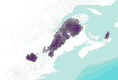
This dataset depicts Lynx (Lynx canadensis) habitat in the Northern Appalachians predicted using the spatially explicit population model PATCH under the no population cycling plus trapping plus 36 square kilometer territory size (compared to 90 square kilometer territory) scenario (A236; Carroll 2007). This dataset represents one of several scenarios testing the interacting effects of population cycling, trapping, territory size, and climate change on lynx populations. Static habitat suitability models for lynx were fed through PATCH to predict source and sink habitat areas across the landscape. The static models for lynx were created based on a logistic regression model of reported lynx locations against the proportion...
Montane regions support distinct animal and plant communities that are widely viewed as communities of high conservation concern due to their significant contribution to regional biodiversity. These communities are also thought to be particularly vulnerable to anthropogenically caused stressors such as climate change, which is generally expected to cause upward shifts and potential range restrictions in montane plant and animal distributions. In the northern Appalachian Mountains of North America, not only is it becoming warmer at mid-elevations but the ecotone between the northern hardwood and the montane coniferous forests is also shifting. Therefore, species that are limited by climate or habitat along the elevational...
Categories: Publication;
Types: Citation;
Tags: Appalachian,
Biodiversity,
Birds,
Birds,
Climate Change,
Systematic conservation planning is well suited to address the many large-scale biodiversity conservation challenges facing the Appalachian region. However, broad, well-connected landscapes will be required to sustain many of the natural resources important to this area into the future. If these landscapes are to be resilient to impending change, it will likely require an orchestrated and collaborative effort reaching across jurisdictional and political boundaries. The first step in realizing this vision is prioritizing discrete places and actions that hold the greatest promise for the protection of biodiversity. Five conservation design elements covering many critical ecological processes and patterns across the...
The National Cohesive Wildland Fire Management Strategy, initiated in 2009 and finalized in 2014, provides a national vision for wildland fire management. This highly collaborative effort establishes three overarching goals, and describes stakeholder-driven processes for achieving them: (1) resilient landscapes; (2) fire-adapted communities; and (3) safe and effective wildfire response. The scientific rigor of this program was ensured with the establishment of the National Science and Analysis Team (NSAT). The main tasks of NSAT were to compile credible scientific information, data, and models to help explore national challenges and opportunities, identify a range of management options, and help set national priorities...
Categories: Data;
Types: ArcGIS REST Map Service,
ArcGIS Service Definition,
Citation,
Downloadable,
Map Service;
Tags: Academics & scientific researchers,
AppLCC,
AppLCC,
Appalachian,
Conservation NGOs,
The Landcover Mosaic map (LCM) can be used to answer the question: What is the mixture of agricultural/urban/natural landcover types surrounding a given land parcel?Researchers at the U.S. Forest Service Southern Research Station have utilized the National Land Cover Database (NLCD) to calculate a suite of land cover and forest fragmentation metrics at landscape scales. These datasets yield rich spatial information about urbanization, its effects on forests, and how urban areas interface and mix with rural, agricultural, and forest landscapes.The Landcover Mosaic Map (Landscape Mosaic Pattern) illustrates the mixture of agricultural, developed, and semi-natural land cover types within 15-hectare neighborhoods (about...
Categories: Data;
Types: ArcGIS REST Map Service,
ArcGIS Service Definition,
Citation,
Downloadable,
Map Service;
Tags: Academics & scientific researchers,
AppLCC,
AppLCC,
Appalachian,
Conservation NGOs,
This dataset depicts the percentage of local catchment land area described as crop in the National Land Cover Database (NLCD) 2011.
Categories: Data;
Types: ArcGIS REST Map Service,
ArcGIS Service Definition,
Citation,
Downloadable,
Map Service,
OGC WFS Layer,
OGC WMS Layer,
OGC WMS Service;
Tags: Academics & scientific researchers,
AppLCC,
AppLCC,
Appalachian,
Conservation NGOs,
Researchers at the U.S. Forest Service Southern Research Station have utilized the National Land Cover Database (NLCD) to calculate a suite of land cover and forest fragmentation metrics at landscape scales. These datasets yield rich spatial information about urbanization, its effects on forests, and how urban areas interface and mix with rural, agricultural, and forest landscapes.The Forest Area Density (FDEN) map (Landscape Forest Density) illustrates the proportion of the landscape around a given forest area that is also forested. Areas with low forest density may be fragmented by agricultural land use and/or urban and exurban development. FDEN map is colored according to the amount of other forest in a surrounding...
Categories: Data;
Types: ArcGIS REST Map Service,
ArcGIS Service Definition,
Citation,
Downloadable,
Map Service;
Tags: Academics & scientific researchers,
AppLCC,
AppLCC,
Appalachian,
Conservation NGOs,
USFS Forest Inventory Analysis Through application of a nearest-neighbor imputation approach, mapped estimates of forest carbon density were developed for the contiguous United States using the annual forest inventory conducted by the U.S. Department of Agriculture (USDA) Forest Service Forest Inventory and Analysis (FIA) program, MODIS satellite imagery, and ancillary geospatial datasets. The U.S. has been providing national-scale estimates of forest carbon stocks and stock change to meet United Nations Framework Convention on Climate Change reporting requirements for years. Although these currently are provided as national estimates by pool and year to meet greenhouse gas monitoring requirements, there is growing...
Categories: Data;
Types: ArcGIS REST Map Service,
ArcGIS Service Definition,
Citation,
Downloadable,
Map Service;
Tags: Academics & scientific researchers,
AppLCC,
AppLCC,
Appalachian,
Conservation NGOs,
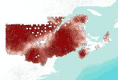
This dataset depicts Wolf (Canis lupus) habitat in the Northern Appalachians predicted using the spatially explicit population model PATCH under the projected habitat effectiveness for 2025 plus low US mortality plus moderate Canadian mortality scenario (Carroll 2003). This dataset represents one of several scenarios testing the effects of habitat effectiveness and mortality rates on wolf populations. Static habitat suitability models for wolf were fed through PATCH to predict source and sink habitat areas across the landscape. The static models for wolf were created based on current and projected habitat effectiveness, which were based in part on road density and human population density. Wolf fecundity rates were...

This dataset depicts Wolf (Canis lupus) habitat in the Northern Appalachians predicted using the spatially explicit population model PATCH under the projected habitat effectiveness for 2025 plus moderate US mortality plus high Canadian mortality scenario (Carroll 2003). This dataset represents one of several scenarios testing the effects of habitat effectiveness and mortality rates on wolf populations. Static habitat suitability models for wolf were fed through PATCH to predict source and sink habitat areas across the landscape. The static models for wolf were created based on current and projected habitat effectiveness, which were based in part on road density and human population density. Wolf fecundity rates...

This dataset depicts Marten (Martes americana) habitat in the Northern Appalachians predicted using the spatially explicit population model PATCH under the increased survival in parks plus timber harvest scenario (L1; Carrol 2007). This dataset represents one of several scenarios testing the interacting effects of trapping, timber harvest, habitat restoration, and climate change on marten populations. Static habitat suitability models for marten were fed through PATCH to predict source and sink habitat areas across the landscape. The static models for marten were created based on annual snowfall and percentage of older conifer and mixed forest. Demographic parameters were obtained from the literature and from calibration...

This dataset depicts Marten (Martes americana) habitat in the Northern Appalachians predicted using the spatially explicit population model PATCH under the current trapping rates plus forest restoration plus climate change scenario (FR2; Carrol 2007). This dataset represents one of several scenarios testing the interacting effects of trapping, timber harvest, habitat restoration, and climate change on marten populations. Static habitat suitability models for marten were fed through PATCH to predict source and sink habitat areas across the landscape. The static models for marten were created based on annual snowfall and percentage of older conifer and mixed forest. Demographic parameters were obtained from the literature...

This dataset depicts Marten (Martes americana) habitat in the Northern Appalachians predicted using the spatially explicit population model PATCH under the current trapping rates plus timber harvest plus climate change scenario (FL2; Carrol 2007). This dataset represents one of several scenarios testing the interacting effects of trapping, timber harvest, habitat restoration, and climate change on marten populations. Static habitat suitability models for marten were fed through PATCH to predict source and sink habitat areas across the landscape. The static models for marten were created based on annual snowfall and percentage of older conifer and mixed forest. Demographic parameters were obtained from the literature...
|

|
