Filters: Tags: british columbia (X) > Date Range: {"choice":"year"} (X)
112 results (15ms)|
Filters
Date Types (for Date Range)
Types
Contacts
Categories Tag Types
|

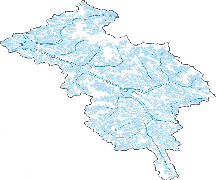
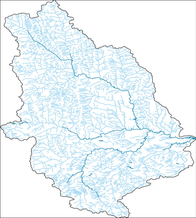
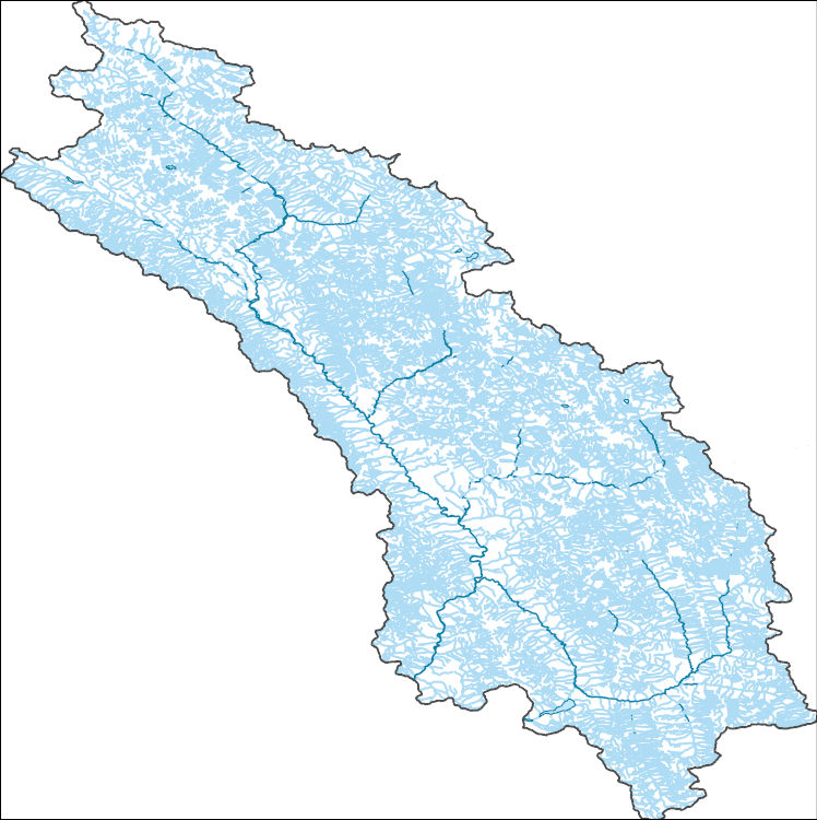
The National Hydrography Dataset (NHD) is a feature-based database that interconnects and uniquely identifies the stream segments or reaches that make up the nation's surface water drainage system. NHD data was originally developed at 1:100,000-scale and exists at that scale for the whole country. This high-resolution NHD, generally developed at 1:24,000/1:12,000 scale, adds detail to the original 1:100,000-scale NHD. (Data for Alaska, Puerto Rico and the Virgin Islands was developed at high-resolution, not 1:100,000 scale.) Local resolution NHD is being developed where partners and data exist. The NHD contains reach codes for networked features, flow direction, names, and centerline representations for areal water...

The National Hydrography Dataset (NHD) is a feature-based database that interconnects and uniquely identifies the stream segments or reaches that make up the nation's surface water drainage system. NHD data was originally developed at 1:100,000-scale and exists at that scale for the whole country. This high-resolution NHD, generally developed at 1:24,000/1:12,000 scale, adds detail to the original 1:100,000-scale NHD. (Data for Alaska, Puerto Rico and the Virgin Islands was developed at high-resolution, not 1:100,000 scale.) Local resolution NHD is being developed where partners and data exist. The NHD contains reach codes for networked features, flow direction, names, and centerline representations for areal water...

The National Hydrography Dataset (NHD) is a feature-based database that interconnects and uniquely identifies the stream segments or reaches that make up the nation's surface water drainage system. NHD data was originally developed at 1:100,000-scale and exists at that scale for the whole country. This high-resolution NHD, generally developed at 1:24,000/1:12,000 scale, adds detail to the original 1:100,000-scale NHD. (Data for Alaska, Puerto Rico and the Virgin Islands was developed at high-resolution, not 1:100,000 scale.) Local resolution NHD is being developed where partners and data exist. The NHD contains reach codes for networked features, flow direction, names, and centerline representations for areal water...
This project will provide a comprehensive synthesis of beaver recolonization science and techniques for successful reintroduction or population expansion through a thorough, in-depth, coordinated review of all North American beaver-related information, including identification of research gaps and data needs, and recommendations for project implementation. This information will be disseminated through a series of one-day workshops.
Categories: Data,
Project;
Types: Map Service,
OGC WFS Layer,
OGC WMS Layer,
OGC WMS Service;
Tags: 2013,
AK-1,
Alaska,
Alaska,
Alaska,
The central objective of this project was to answer two questions: 1) how downscaled climate datasets, modeled vegetation changes, and information on estimated species sensitivities can be used to develop climate change adaptation strategies, and 2) how model results and datasets can be made more useful for informing the management of species and landscapes. To answer these questions, we identified enthusiastic partners working in two very different complex landscapes within the North Pacific Landscape Conservation Cooperative (NPLCC): 1) the British Columbia Park system, specifically the midcoast region, and 2) the National Wildlife Refuge system in the Willamette Valley, OR. The issues and concerns of each group...
Categories: Data;
Tags: Academics & scientific researchers,
B.C.,
BC Provincial parks,
British Columbia,
Conservation Planning,
This project will create a targeted and easily understandable guide to tools that support landscape-level planning in the face of climate change for NPLCC partners. The guide will build on previous NPLCC research on decision support needs with an emphasis on tools currently in use in the region. A survey of NPLCC partners will discover who is currently using or planning to use tools in the region, tools they are using, how well these tools are meeting their needs, and regional and outside experts engaged in tool use. Additional tools research will provide information on tools not currently in use in the region that could also provide needed functionality.
Categories: Data;
Types: Map Service,
OGC WFS Layer,
OGC WMS Layer,
OGC WMS Service;
Tags: Academics & scientific researchers,
Ak-1,
Alaska,
British Columbia,
CA-2,
For the past six years, the Bureau of Reclamation (BOR) has funded the USGS to study fish responses to restoration efforts and to construct a model relating stream habitat with fish population dynamics in the Methow River Basin, a tributary of the Columbia River. In the proposed study, we will use fish growth, distribution and movement (USGS data), foodweb data (Idaho State University), river flow (BOR data that we will expand) and water temperature data (from numerous agencies) to develop spatially-explicit bioenergetics models to assess effects of climate change on the viability of resident salmonid populations based on models being developed by USGS. The bioenergetics models will integrate such things as climate-change...
Categories: Data,
Project;
Types: Map Service,
OGC WFS Layer,
OGC WMS Layer,
OGC WMS Service;
Tags: Alberta,
British Columbia,
Bull Trout,
Climate Change,
Climate Change,
The GNLCC Multi-dimensional Synthesis is a synthesis of existing information in four categories to promote a common understanding of situation, existing information and information gaps, as well as providing an index of programmatic, resource and other climate and landscape related information for GNLCC. The synthesis includes: the GNLCC Resource Directory (organizations and initiatives); climate and ecological response (what does existing and projected climate information say and what are expected ecological effects); and monitoring (who is monitoring what).FY2011Objectives:Provide a Framework from which to organize the various monitoring and evaluation efforts. Included are key monitoring and evaluation questions...
Categories: Data,
Project;
Types: Map Service,
OGC WFS Layer,
OGC WMS Layer,
OGC WMS Service;
Tags: Alberta,
British Columbia,
CO-2,
CO-3,
CO-3,
We propose a collaborative project with the USGS, Wyoming State Climate Office, USFWS, USFS, and the NPS whereby we will assemble and maintain long-term records of climate from key stations in and around the Great Northern LCC and subject these records to a rigorous series of QA/QC procedures. Where appropriate we will use best available practices to infill missing data, and we will develop station histories (e.g., details of station moves, instrumentation changes, etc.) as a context for interpreting these records. We will then rigorously analyze patterns of long-term (50-100 years) variability and trends in these datasets, and provide summaries designed to meet the needs of non-climate specialists working in the...
Categories: Data,
Project;
Types: Map Service,
OGC WFS Layer,
OGC WMS Layer,
OGC WMS Service;
Tags: Alberta,
British Columbia,
CO-2,
CO-3,
CO-3,
The Canadian portion of the Crown of the Continent (CCoC) ecosystem has been identified as crucial for wolverines north of the US border to rescue or supply individuals and genes through dispersal to the highly fragmented population in the northern US Rocky Mountains. Highway 3, motorized recreation, and a growing resource extraction industry, however, increasingly fragment this critical landscape. This project will capitalize on multi-year wolverine occupancy and genetic data collected noninvasively in a >40,000 km2 area encompassing the core protected areas of the central Canadian Rocky Mountains to the north; and Glacier-Waterton Lakes National Park complex in the south. Our goal is to obtain spatially-explicit...
Categories: Data,
Project;
Types: Map Service,
OGC WFS Layer,
OGC WMS Layer,
OGC WMS Service;
Tags: Alberta,
Alpine,
Applications and Tools,
British Columbia,
Climate Change,
This dataset contains a seamless 1:1,000,000 scale British Columbia, Alberta and Montana lakes layer.
Categories: Data;
Types: Downloadable,
Map Service,
OGC WFS Layer,
OGC WMS Layer,
Shapefile;
Tags: 1:1 000 000,
1:1 000 000,
Alberta,
Alberta,
British Columbia,
The National Hydrography Dataset (NHD) is a feature-based database that interconnects and uniquely identifies the stream segments or reaches that make up the nation's surface water drainage system. NHD data was originally developed at 1:100,000-scale and exists at that scale for the whole country. This high-resolution NHD, generally developed at 1:24,000/1:12,000 scale, adds detail to the original 1:100,000-scale NHD. (Data for Alaska, Puerto Rico and the Virgin Islands was developed at high-resolution, not 1:100,000 scale.) Local resolution NHD is being developed where partners and data exist. The NHD contains reach codes for networked features, flow direction, names, and centerline representations for areal water...
Canadian discrete water quality data and daily streamflow records were evaluated using the Weighted Regression on Time, Discharge, and Seasons (WRTDS) model implemented with the EGRET R package (Hirsch et al. 2010, Hirsch and De Cicco 2015). Models were used to estimate loads of solutes and evaluate trends for three constituents of interest (selenium, nitrate, and sulfate). Six models were generated; one model for each of the three constituents of interest, in each of the two major tributaries to Lake Koocanusa: the Kootenay River at Fenwick (BC08NG0009), and the Elk River above Highway 93 Near Elko (BC08NK0003). Data were obtained by downloading data from the British Columbia Water Tool (https://kwt.bcwatertool.ca/surface-water-quality,...
This workshop introduced and demonstrated key concepts and a series of software tools, whichallow managers, biologists, and conservationists to efficiently evaluate predictors of wildlife space-use and generate spatial models based on that analysis.Specific content of the workshop: Access to free or low-cost remote sensing information on vegetation, climate, habitat metrics, disturbance, etc., in a useable format, including covariate datasets currently available or under development by the NASA Terrestrial Observation and Prediction System (TOPS) Explanation of how this information is derived, created, integrated, validated and matched with species data sets prior to analysis Demonstration of user-friendly computer...
Categories: Data,
Project;
Types: Map Service,
OGC WFS Layer,
OGC WMS Layer,
OGC WMS Service;
Tags: Academics & scientific researchers,
Alberta,
British Columbia,
CO-2,
CO-3,
Defenders staff, contractors and Great Northern Landscape Conservation Cooperative partners will build a portal on the Conservation Registry to visualize landscape scale plans and conservation projects that address the priorities of the program. The portal will integrate with GN LCCs existing project management tool, LC Map, to spatially display plans within the geographic area of the LCC, provide information about the plans, and link to planning documents. services and/or data imports will be programmed to facilitate efficient transfer of project data from LC Map and other agencies and organizations into the Registry. FY2012Objectives: Coordination with Heart of the Rockies (HotR) staff to identify focal area,...
Categories: Data,
Project;
Types: Map Service,
OGC WFS Layer,
OGC WMS Layer,
OGC WMS Service;
Tags: Academics & scientific researchers,
Alberta,
British Columbia,
Climate Change,
Connectivity,
The National Hydrography Dataset (NHD) is a feature-based database that interconnects and uniquely identifies the stream segments or reaches that make up the nation's surface water drainage system. NHD data was originally developed at 1:100,000-scale and exists at that scale for the whole country. This high-resolution NHD, generally developed at 1:24,000/1:12,000 scale, adds detail to the original 1:100,000-scale NHD. (Data for Alaska, Puerto Rico and the Virgin Islands was developed at high-resolution, not 1:100,000 scale.) Local resolution NHD is being developed where partners and data exist. The NHD contains reach codes for networked features, flow direction, names, and centerline representations for areal water...
The National Hydrography Dataset (NHD) is a feature-based database that interconnects and uniquely identifies the stream segments or reaches that make up the nation's surface water drainage system. NHD data was originally developed at 1:100,000-scale and exists at that scale for the whole country. This high-resolution NHD, generally developed at 1:24,000/1:12,000 scale, adds detail to the original 1:100,000-scale NHD. (Data for Alaska, Puerto Rico and the Virgin Islands was developed at high-resolution, not 1:100,000 scale.) Local resolution NHD is being developed where partners and data exist. The NHD contains reach codes for networked features, flow direction, names, and centerline representations for areal water...
This project will provide a comprehensive synthesis of beaver recolonization science and techniques for successful reintroduction or population expansion through a thorough, in-depth, coordinated review of all North American beaver-related information, including identification of research gaps and data needs, and recommendations for project implementation. This information will be disseminated through a series of one-day workshops.
Categories: Data;
Types: Map Service,
OGC WFS Layer,
OGC WMS Layer,
OGC WMS Service;
Tags: AK-1,
Alaska,
Beaver,
British Columbia,
CA-2,
This project applied sea-level rise (SLR) modeling approaches along the Pacific coast tidal gradient at a parcel scale through improved data collection tools and collaboration relevant to land managers. At selected salt marsh parcels in both the North Pacific and California LCCs, data collection techniques were employed to assess detailed baseline habitat elevations; tidal ranges, microclimate, and extreme weather events; sediment supply sources; vegetation community composition; and vertebrate population indices. The design provides resource managers with information on the value of different datasets and methods including their uncertainty, as well as determines their usefulness in climate change adaptation planning...
Categories: Data,
Project;
Types: Map Service,
OGC WFS Layer,
OGC WMS Layer,
OGC WMS Service;
Tags: 2011,
Academics & scientific researchers,
Alaska,
British Columbia,
CA-2,
In May 2014, the GNLCC Steering Committee approved two pilot projects explore approaches to landscape-scale coordination to enhance science-based management across the GNLCC. The two ‘Shared Landscape Outcomes’ pilots were designed to assess and focus on specific pairs of a GNLCC Goal and a priority landscape stressor (as defined in the Strategic Conservation Framework) and focus the approach at the entire GNLCC scale. The two pilot projects focused on (1) the Connectivity goal and Land Use Change stressor (described here) and (2) the Aquatic Integrity goal and Invasives stressor and (see: https://www.fws.gov/science/catalog )Connectivity Pilot:Wildlife species are becoming increasingly isolated in patches of habitat,...
Categories: Data,
Project;
Types: Map Service,
OGC WFS Layer,
OGC WMS Layer,
OGC WMS Service;
Tags: Alberta,
Aquatic Connectivity,
British Columbia,
Bull Trout,
Cascadia,
|

|
