Filters: Tags: cities (X) > partyWithName: Conservation Biology Institute (X)
7 results (50ms)|
Filters
Date Range
Tag Schemes |

A joint venture involving the National Atlas programs in Canada (Natural Resources Canada), Mexico (Instituto Nacional de Estadística Geografía e Informática), and the United States (U.S. Geological Survey), as well as the North American Commission for Environmental Co-operation, has led to the release (June 2004) of several new products: an updated paper map of North America, and its associated geospatial data sets and their metadata. These data sets are available online from each of the partner countries both for visualization and download. The North American Atlas data are standardized geospatial data sets at 1:10,000,000 scale. A variety of basic data layers (e.g. roads, railroads, populated places, political...

A geographic representation of the municipal boundaries created from fund numbers which are provided by the County Auditor/Controller's Property Tax Services (PTS) Division.

World Urban Areas represents the world's major urban areas with populations greater than 10,000. Source: DeLorme Publishing Company, Inc.

The DLG data files derived from the 1:2,000,000-scale maps contain selected base categories of cartographic data in digital form. The data files are derived from the sectional maps of the 1970 National Atlas of the United States of America. The Boundaries category includes boundary information collected in two separate subcategories: (1) Political Boundaries and (2) Administrative Boundaries. The Hydrography data includes data in three separate subcategories: (1) Streams, (2) Water Bodies, and (3) Hypsography (Continental Divide only). The Transportation category of data includes major transportation systems collected in three separate subcategories: (1) Roads and Trails, (2) Railroads, and (3) Cultural Features...
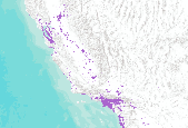
20 year Projected Urban Growth scenarios. Base year is 2000. Projected year in this dataset is 2020. Acquired from Cal-Atlas at http://www.atlas.ca.gov/download.html#/casil/society .

50 year Projected Urban Growth scenarios. Base year is 2000. Projected year in this dataset is 2020. Acquired from Cal-Atlas at http://www.atlas.ca.gov/download.html#/casil/society.
The Geographic Names Information System (GNIS), developed by the U.S. Geological Survey in cooperation with the U.S. Board on Geographic Names (BGN), contains information about physical and cultural geographic features in the United States and associated areas, both current and historical, but not including roads and highways. The database also contains geographic names in Antarctica. The database holds the Federally recognized name of each feature and defines the location of the feature by state, county, USGS topographic map, and geographic coordinates. Other feature attributes include names or spellings other than the official name, feature designations, feature class, historical and descriptive information, and...
|

|
