Filters: Tags: classification (X)
55 results (5ms)|
Filters
|

These data were released prior to the October 1, 2016 effective date for the USGS’s policy dictating the review, approval, and release of scientific data as referenced in USGS Survey Manual Chapter 502.8 Fundamental Science Practices: Review and Approval of Scientific Data for Release. Estuarine ecosystems are controlled by a variety of processes that operate at multiple spatial and temporal scales. Understanding the hierarchical nature of these processes will aid in prioritization of restoration efforts. This hierarchical Columbia River Estuary Ecosystem Classification (henceforth "Classification") of the Columbia River estuary is a spatial database of the tidally-influenced reaches of the lower Columbia River,...

These data were released prior to the October 1, 2016 effective date for the USGS’s policy dictating the review, approval, and release of scientific data as referenced in USGS Survey Manual Chapter 502.8 Fundamental Science Practices: Review and Approval of Scientific Data for Release. Estuarine ecosystems are controlled by a variety of processes that operate at multiple spatial and temporal scales. Understanding the hierarchical nature of these processes will aid in prioritization of restoration efforts. This hierarchical Columbia River Estuary Ecosystem Classification (henceforth "Classification") of the Columbia River estuary is a spatial database of the tidally-influenced reaches of the lower Columbia River,...
This dataset represents the soil order from SSURGO and STATSGO soil descriptions for soil map units in the state of southern Alaska (b) that lie within the North Pacific Landscape Conservation Cooperative.
River valley boundary extents were generated for select large river floodplains of the Upper Midwest, United States. These polygons were delineated using a method that incorporated interpolating a water surface elevation that completely over-topped water-control structures within the valley such as levees, flood walls, and roadways. The intersection of this derived water surface and land elevation at the outermost edge of the floodplain was used to delineate the approximate extent of the river valley boundary. We used best professional judgment to approximate this water surface elevation.
Categories: Data;
Types: Downloadable,
Map Service,
OGC WFS Layer,
OGC WMS Layer,
Shapefile;
Tags: Illinois,
Indiana,
Iowa,
Kansas,
Kentucky,
This dataset is a component of a complete package of products from the Connect the Connecticut project. Connect the Connecticut is a collaborative effort to identify shared priorities for conserving the Connecticut River Watershed for future generations, considering the value of fish and wildlife species and the natural ecosystems they inhabit. Click here to download the full data package, including all documentation.This dataset represents the climate response index for Eastern Meadowlark. Climate response is one of several different measures of landscape capability that reflect different decisions (or assumptions) regarding how to incorporate current versus future land use and climate changes. The climate response...
Categories: Data;
Types: ArcGIS REST Map Service,
ArcGIS Service Definition,
Citation,
Downloadable,
Map Service;
Tags: Data,
LCC Network Science Catalog,
North Atlantic Landscape Conservation Cooperative Data.gov,
change,
change,
This dataset is a component of a complete package of products from the Connect the Connecticut project. Connect the Connecticut is a collaborative effort to identify shared priorities for conserving the Connecticut River Watershed for future generations, considering the value of fish and wildlife species and the natural ecosystems they inhabit. Click here to download the full data package, including all documentation.This dataset represents the climate response index for Moose. Climate response is one of several different measures of landscape capability that reflect different decisions (or assumptions) regarding how to incorporate current versus future land use and climate changes. The climate response index is...
Categories: Data;
Types: ArcGIS REST Map Service,
ArcGIS Service Definition,
Citation,
Downloadable,
Map Service;
Tags: Data,
LCC Network Science Catalog,
North Atlantic Landscape Conservation Cooperative Data.gov,
change,
change,

This dataset represents the soil order from SSURGO and STATSGO soil descriptions for soil map units in the state of western Oregon that lie within the North Pacific Landscape Conservation Cooperative.

This dataset represents the soil order from SSURGO and STATSGO soil descriptions for soil map units in the state of southern Alaska (b) that lie within the North Pacific Landscape Conservation Cooperative.

This dataset covers the southern half of the Southern Rockies Landscape Conservation Cooperative. It was aggregated and converted to raster by Conservation Biology Institute as part of a soil vulnerability study funded in part by the Southern Rockies LCC. The soil data come from a digital soil survey, the most detailed level of soil geographic data developed by the National Cooperative Soil Survey. The information was prepared by digitizing maps, by compiling information onto a planimetric correct base and digitizing, or by revising digitized maps using remotely sensed and other information. This data set consists of georeferenced digital map data and computerized attribute data. The map data are in a soil survey...
The need for integrated and widely accessible sources of species traits data to facilitate studies of ecology, conservation, and management has motivated development of traits databases for various taxa. In spite of the increasing number of traits-based analyses of freshwater fishes in the United States, no consolidated database of traits of this group exists publicly, and much useful information on these species is documented only in obscure sources. The largely inaccessible and unconsolidated traits information makes large-scale analysis involving many fishes and/or traits particularly challenging. We have compiled a database of >100 traits for 809 (731 native and 78 nonnative) fish species found in freshwaters...
This dataset is a component of a complete package of products from the Connect the Connecticut project. Connect the Connecticut is a collaborative effort to identify shared priorities for conserving the Connecticut River Watershed for future generations, considering the value of fish and wildlife species and the natural ecosystems they inhabit. Click here to download the full data package, including all documentation. This dataset represents the climate response index for Prairie Warbler. Climate response is one of several different measures of landscape capability that reflect different decisions (or assumptions) regarding how to incorporate current versus future land use and climate changes. The climate response...
Categories: Data;
Types: ArcGIS REST Map Service,
ArcGIS Service Definition,
Citation,
Downloadable,
Map Service;
Tags: Data,
LCC Network Science Catalog,
North Atlantic Landscape Conservation Cooperative Data.gov,
change,
change,
This dataset is a component of a complete package of products from the Connect the Connecticut project. Connect the Connecticut is a collaborative effort to identify shared priorities for conserving the Connecticut River Watershed for future generations, considering the value of fish and wildlife species and the natural ecosystems they inhabit. Click here to download the full data package, including all documentation. This dataset represents the climate response index for Blackpoll Warbler. Climate response is one of several different measures of landscape capability that reflect different decisions (or assumptions) regarding how to incorporate current versus future land use and climate changes. The climate response...
Categories: Data;
Types: ArcGIS REST Map Service,
ArcGIS Service Definition,
Citation,
Downloadable,
Map Service;
Tags: Data,
LCC Network Science Catalog,
North Atlantic Landscape Conservation Cooperative Data.gov,
change,
change,

These data were released prior to the October 1, 2016 effective date for the USGS’s policy dictating the review, approval, and release of scientific data as referenced in USGS Survey Manual Chapter 502.8 Fundamental Science Practices: Review and Approval of Scientific Data for Release. Estuarine ecosystems are controlled by a variety of processes that operate at multiple spatial and temporal scales. Understanding the hierarchical nature of these processes will aid in prioritization of restoration efforts. This hierarchical Columbia River Estuary Ecosystem Classification (henceforth "Classification") of the Columbia River estuary is a spatial database of the tidally-influenced reaches of the lower Columbia River,...

This dataset contains polygons describing photo interpreted map classifications of the Tongass National Forest developed in 1978. The dataset's primary objective was to delineate major land types and their attributes. The land types were mapped at a polygon level - areas generally homogenous in character. Mapping was done to a 10 acre minimum except for non-commercial and non-forest types which were mapped to a 5 acre minimum. The classification identifies water as well as land. It segregates land into non-forest and forest. Polygons in forested areas were assigned a single, representative set of attributes; species composition, age, and volume class. Tim86 was updated in the 1980's (mostly in 1986) to reflect timber...
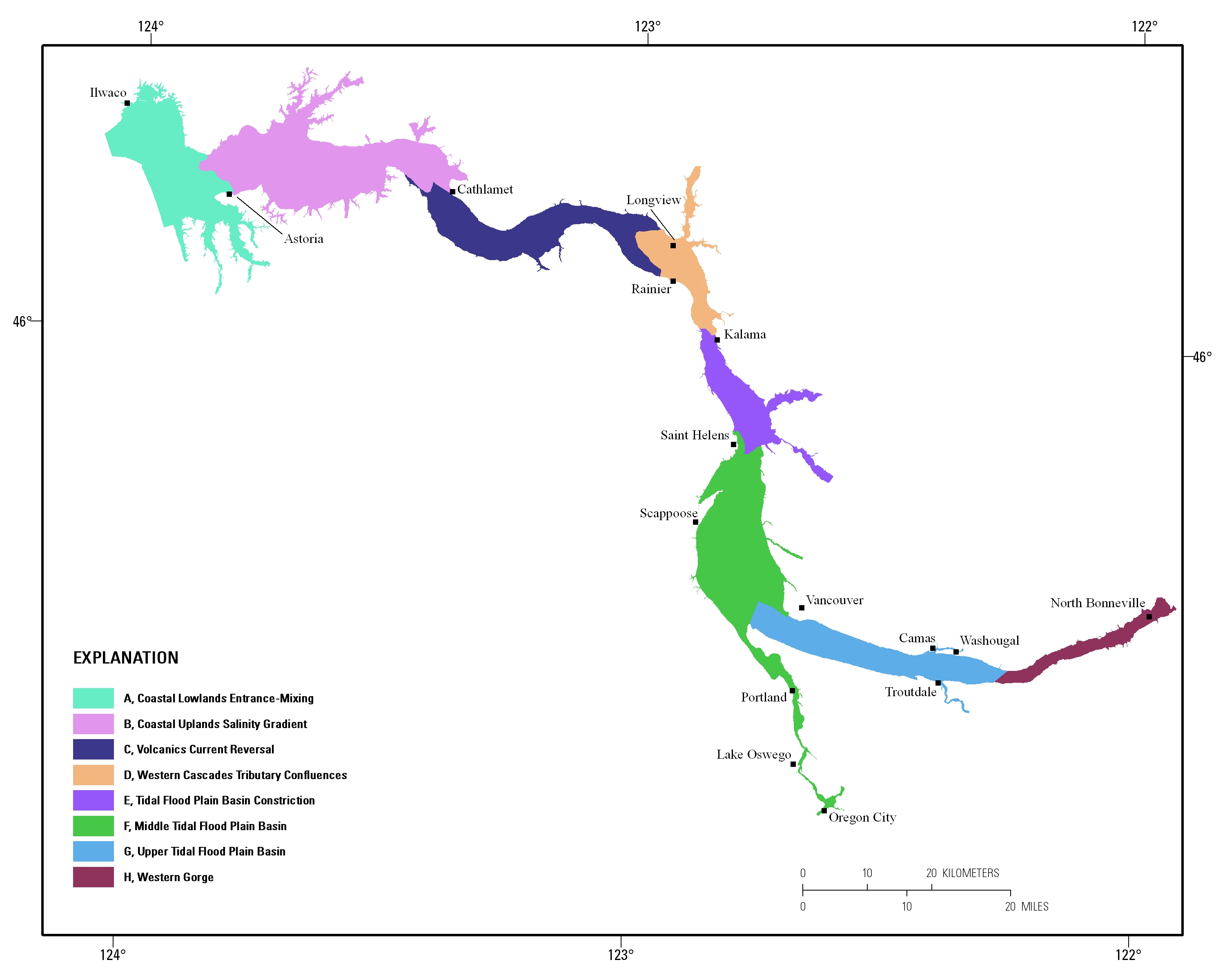
Estuarine ecosystems are controlled by a variety of processes that operate at multiple spatial and temporal scales. Understanding the hierarchical nature of these processes will aid in prioritization of restoration efforts. This hierarchical Columbia River Estuary Ecosystem Classification (henceforth "Classification") of the Columbia River estuary is a spatial database of the tidally-influenced reaches of the lower Columbia River, the tidally affected parts of its tributaries, and the landforms that make up their floodplains for the 230 kilometers between the Pacific Ocean and Bonneville Dam. This work is a collaborative effort between University of Washington School of Aquatic and Fishery Sciences (henceforth "UW"),...
Categories: Publication;
Types: Citation;
Tags: Biology,
Biology: methods,
Classification,
Classification: methods,
Computational Biology,
Coarse-scale vegetation classification developed from 18 regional maps and mosaicked to provide continuous coverage of the YKL study area. These data are provided by Bureau of Land Management (BLM) "as is" and may contain errors or omissions. The User assumes the entire risk associated with its use of these data and bears all responsibility in determining whether these data are fit for the User's intended use. These data may not have the accuracy, resolution, completeness, timeliness, or other characteristics appropriate for applications that potential users of the data may contemplate. The User is encouraged to carefully consider the content of the metadata file associated with these data. The BLM should be cited...
These data were compiled for the creation of a continuous, transboundary land cover map of Bird Conservation Region 33, Sonoran and Mojave Deserts (BCR 33). Objective(s) of our study were to, 1) develop a machine learning (ML) algorithm trained to classify vegetation land cover using remote sensing spectral data and phenology metrics from 2013-2020, over a large subregion of the Sonoran and Mojave Deserts BCR, 2) Calibrate, validate, and refine the final ML-derived vegetation map using a collection of openly sourced remote sensing and ground-based ancillary data, images, and limited fieldwork, and 3) Harmonize a new transboundary classification system by expanding existing land cover mapping resources from the United...
Categories: Data;
Types: Downloadable,
GeoTIFF,
Map Service,
Raster;
Tags: Arizona,
Baja California,
Botany,
California,
Ecology,
This dataset is a component of a complete package of products from the Connect the Connecticut project. Connect the Connecticut is a collaborative effort to identify shared priorities for conserving the Connecticut River Watershed for future generations, considering the value of fish and wildlife species and the natural ecosystems they inhabit. Click here to download the full data package, including all documentation.This dataset represents the climate response index for Northern Waterthrush. Climate response is one of several different measures of landscape capability that reflect different decisions (or assumptions) regarding how to incorporate current versus future land use and climate changes. The climate response...
Categories: Data;
Types: ArcGIS REST Map Service,
ArcGIS Service Definition,
Citation,
Downloadable,
Map Service;
Tags: Data,
LCC Network Science Catalog,
North Atlantic Landscape Conservation Cooperative Data.gov,
change,
change,
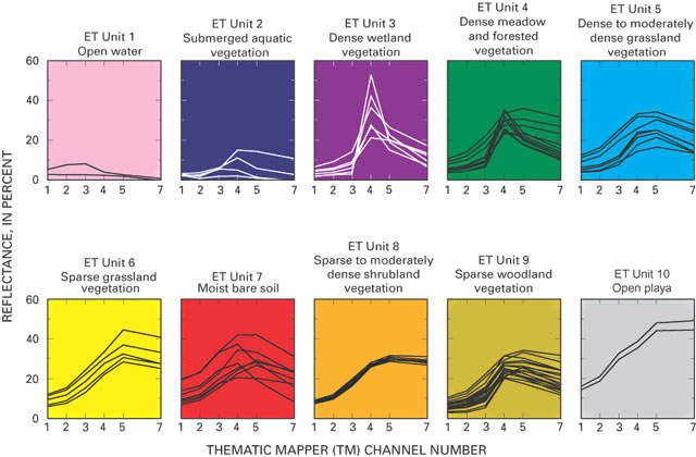
These data were released prior to the October 1, 2016 effective date for the USGS’s policy dictating the review, approval, and release of scientific data as referenced in USGS Survey Manual Chapter 502.8 Fundamental Science Practices: Review and Approval of Scientific Data for Release. The raster-based classification of evapotranspiration (ET) units is for nine major discharge areas in the Death Valley regional flow system. The ET units delineate general areas of similar vegetation and soil-moisture conditions. Classifications were derived from Landsat Thematic Mapper imagery data acquired June 13, 1992; Sept. 1, 1992; and June 21, 1989.
|

|
