Filters: Tags: classification (X)
55 results (74ms)|
Filters
Date Range
Extensions Types
Contacts
Categories
Tag Types
|
This dataset represents the soil order from SSURGO and STATSGO soil descriptions for soil map units in the state of western Oregon that lie within the North Pacific Landscape Conservation Cooperative.

This dataset covers the northern half of the Southern Rockies Landscape Conservation Cooperative. It was aggregated and converted to raster by Conservation Biology Institute as part of a soil vulnerability study funded in part by the Southern Rockies LCC. The soil data come from a digital soil survey, the most detailed level of soil geographic data developed by the National Cooperative Soil Survey. The information was prepared by digitizing maps, by compiling information onto a planimetric correct base and digitizing, or by revising digitized maps using remotely sensed and other information. This data set consists of georeferenced digital map data and computerized attribute data. The map data are in a soil survey...
River valley boundary extents were generated for select large river floodplains of the Upper Midwest, United States. These polygons were delineated using a method that incorporated interpolating a water surface elevation that completely over-topped water-control structures within the valley such as levees, flood walls, and roadways. The intersection of this derived water surface and land elevation at the outermost edge of the floodplain was used to delineate the approximate extent of the river valley boundary. We used best professional judgment to approximate this water surface elevation. River transects were generated at 1-mile increments across select large river floodplains of the Upper Midwest, United States....
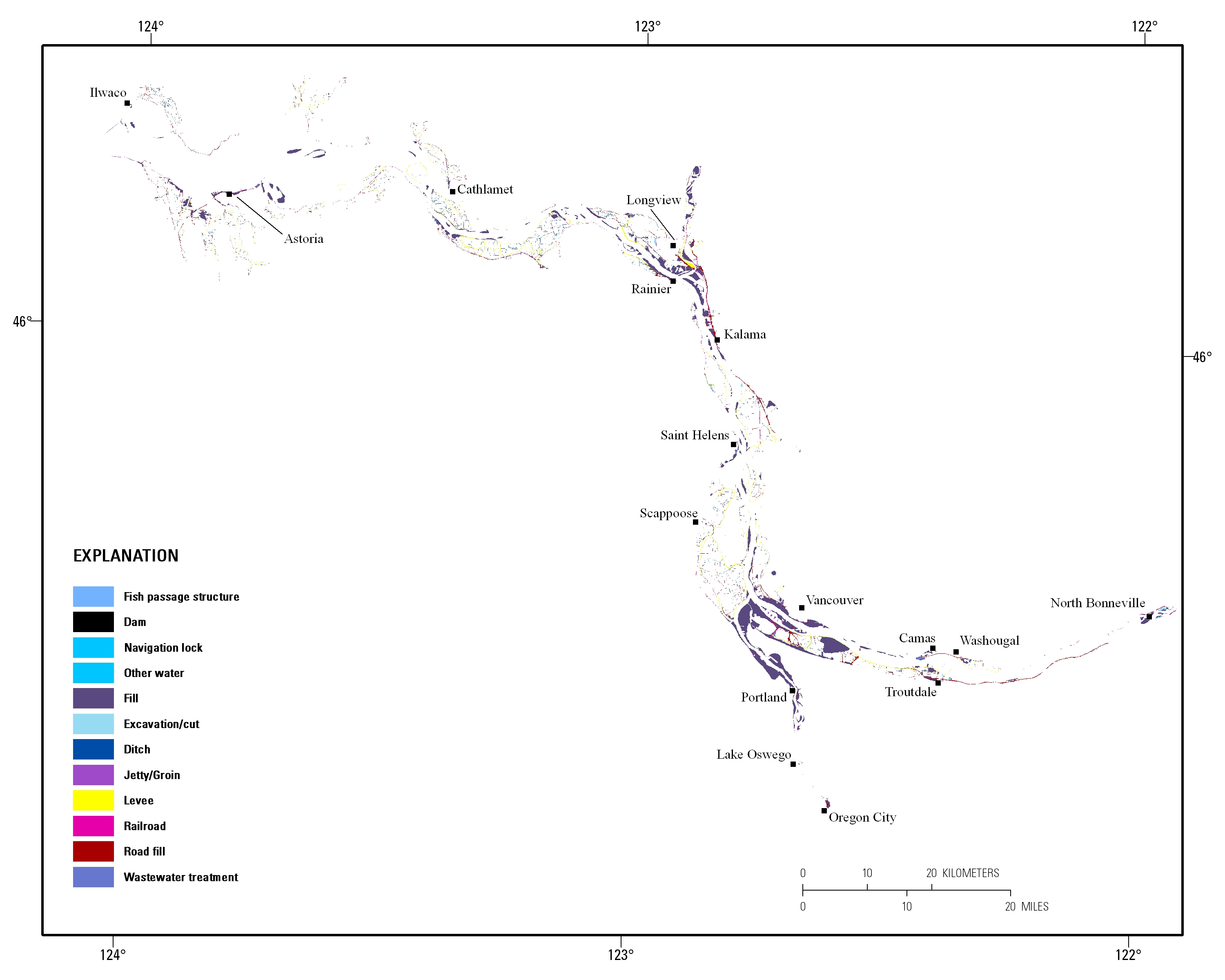
Estuarine ecosystems are controlled by a variety of processes that operate at multiple spatial and temporal scales. Understanding the hierarchical nature of these processes will aid in prioritization of restoration efforts. This hierarchical Columbia River Estuary Ecosystem Classification (henceforth "Classification") of the Columbia River estuary is a spatial database of the tidally-influenced reaches of the lower Columbia River, the tidally affected parts of its tributaries, and the landforms that make up their floodplains for the 230 kilometers between the Pacific Ocean and Bonneville Dam. This work is a collaborative effort between University of Washington School of Aquatic and Fishery Sciences (henceforth "UW"),...
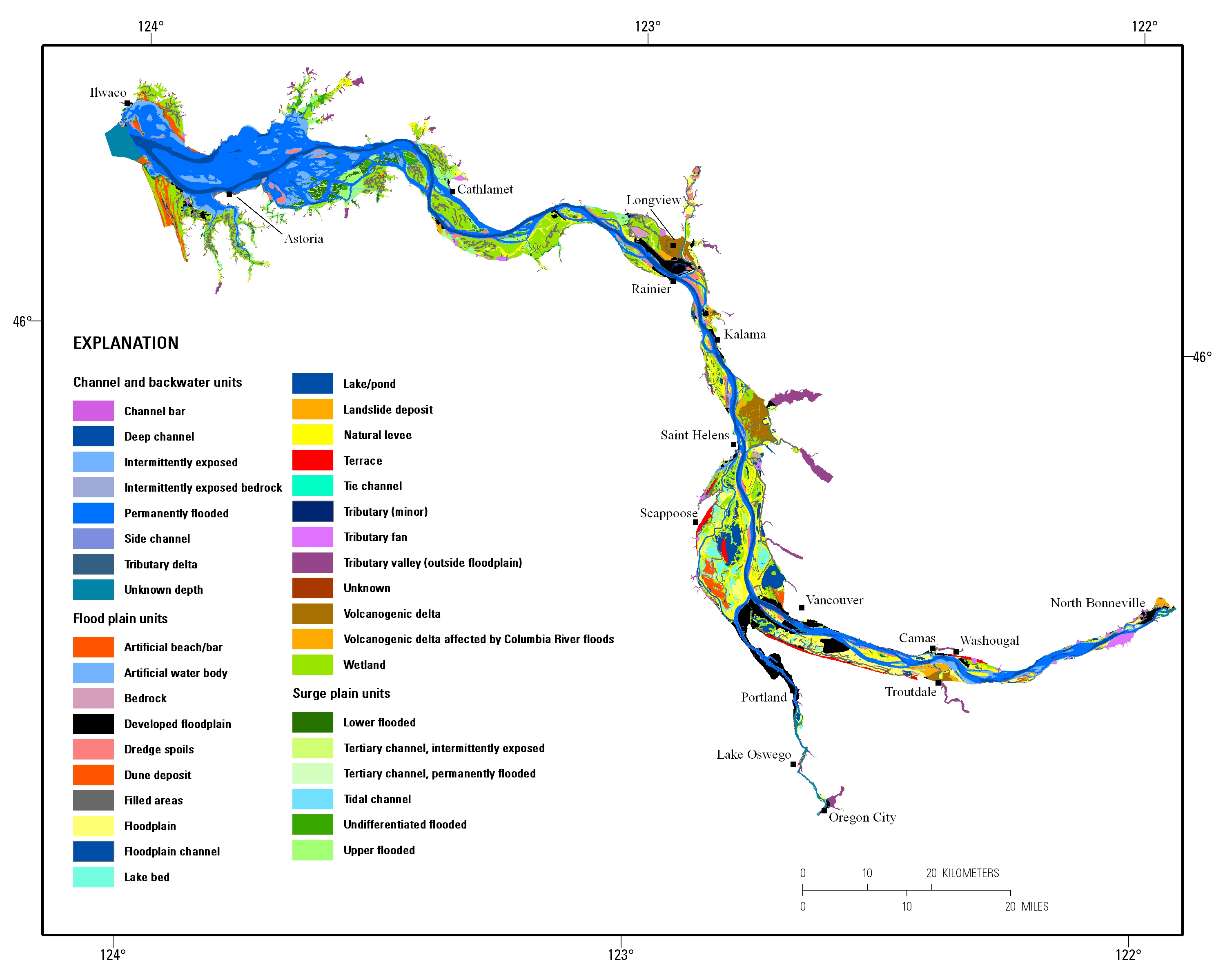
Estuarine ecosystems are controlled by a variety of processes that operate at multiple spatial and temporal scales. Understanding the hierarchical nature of these processes will aid in prioritization of restoration efforts. This hierarchical Columbia River Estuary Ecosystem Classification (henceforth "Classification") of the Columbia River estuary is a spatial database of the tidally-influenced reaches of the lower Columbia River, the tidally affected parts of its tributaries, and the landforms that make up their floodplains for the 230 kilometers between the Pacific Ocean and Bonneville Dam. This work is a collaborative effort between University of Washington School of Aquatic and Fishery Sciences (henceforth "UW"),...
Intermontane basins in the Trans-Pecos region of westernmost Texas and northern Chihuahua, Mexico, are target areas for disposal of interstate municipal sludge and have been identified as possible disposal sites for low-level radioactive waste. Understanding ground water movement within and between these basins is needed to assess potential contaminant fate and movement. Four associated basin aquifers are evaluated and classified; the Red Light Draw Aquifer, the Northwest Eagle Flat Aquifer, the Southeast Eagle Flat Aquifer, and the El Cuervo Aquifer. Encompassed on all but one side by mountains and local divides, the Red Light Draw Aquifer has the Rio Grande as an outlet for both surface drainage and ground water...
Categories: Publication;
Types: Citation,
Journal Citation;
Tags: Classification,
Geological Phenomena,
Geology,
Ground Water,
Mexico,
We outfitted nine condors in a flight pen with patagial tags, each with a unique ID, and a proprietary solar powered Global Positioning System-Global System for Mobile Communications (GPS-GSM) telemetry device weighing 50 g (Cellular Tracking Technologies, LLC, Rio Grande, NJ). The units collected tri-axial acceleration data at a rate of 20 Hz. Data were transmitted once daily over cellular networks and then downloaded to a server.
Categories: Data;
Tags: Accelerometer,
Classification,
Ecology,
Machine learning,
USGS Science Data Catalog (SDC),
Releasing the spreadsheet of training data performance assessments.
Categories: Data,
Data Release - In Progress;
Tags: Conterminous U.S.,
Land cover change,
Landsat,
biota,
classification,
The U.S. Geological Survey (USGS) previously identified 62 Principal Aquifers (PAs) in the U.S., with 57 located in the conterminous states. The USGS characterized areas outside of PAs as “other rocks;” other rocks account for about 40% of the area of the conterminous states. This paper subdivides the large area identified as other rocks into Secondary Hydrogeologic Regions (SHRs). SHRs are defined as areas of other rock within which the rocks are of comparable geologic age, lithology, and relationship to the presence or absence of underling PAs or overlying glacial deposits. A total of 69 SHRs were identified. SHRs were identified in two phases. In the first phase, Other Rock Regions (ORRs) were defined as regions...
Categories: Data Release - Revised;
Tags: Aquifers,
Classification,
Confining Layers,
Groundwater,
Hydrogeology,
This dataset is a component of a complete package of products from the Connect the Connecticut project. Connect the Connecticut is a collaborative effort to identify shared priorities for conserving the Connecticut River Watershed for future generations, considering the value of fish and wildlife species and the natural ecosystems they inhabit. Click here to download the full data package, including all documentation.This dataset represents the climate response index for Ruffed Grouse. Climate response is one of several different measures of landscape capability that reflect different decisions (or assumptions) regarding how to incorporate current versus future land use and climate changes. The climate response...
Categories: Data;
Types: ArcGIS REST Map Service,
ArcGIS Service Definition,
Citation,
Downloadable,
Map Service;
Tags: Data,
LCC Network Science Catalog,
North Atlantic Landscape Conservation Cooperative Data.gov,
change,
change,
This dataset is a component of a complete package of products from the Connect the Connecticut project. Connect the Connecticut is a collaborative effort to identify shared priorities for conserving the Connecticut River Watershed for future generations, considering the value of fish and wildlife species and the natural ecosystems they inhabit. Click here to download the full data package, including all documentation. This dataset represents the climate response index for Wood Thrush. Climate response is one of several different measures of landscape capability that reflect different decisions (or assumptions) regarding how to incorporate current versus future land use and climate changes. The climate response...
Categories: Data;
Types: ArcGIS REST Map Service,
ArcGIS Service Definition,
Citation,
Downloadable,
Map Service;
Tags: Data,
LCC Network Science Catalog,
North Atlantic Landscape Conservation Cooperative Data.gov,
change,
change,
River transects were generated at 1-mile increments across select large river floodplains of the Upper Midwest, United States. These transects were created perpendicular to the river valley bottom centerline and were clipped by the floodplain boundary also generated. Transects that extended up into the valleys of connecting tributaries were not included because of spatial bias toward very large values. Inclusive features within the derived valley bottom outline such as raised plateaus were removed. The total length of these extended transects was then calculated. Five separate variables were developed to assess geomorphic connectivity potential using the transects: channel sinuosity, average floodplain width, standard...
Categories: Data;
Types: Downloadable,
Map Service,
OGC WFS Layer,
OGC WMS Layer,
Shapefile;
Tags: Illinois,
Indiana,
Iowa,
Kansas,
Kentucky,
Categories: Publication;
Types: Citation;
Tags: Classification,
Classification: methods,
Computational Biology,
Computational Biology: trends,
Databases,
We developed a mapped classification of lakes and ponds based on variables that structure lacustrine natural communities and that could be mapped consistently across Northeastern US. The classification was built upon four key attributes: water temperature, trophic state, alkalinity, and depth. Water temperature was mapped into three classes (very cold, cold, and warm-cool) to reflect the requirements and limits of aquatic organisms. Trophic states, representing the productivity of a lake, were mapped into two classes (oligomesotrophic -mesotrophic and eutrophic- hypereutrophic). Alkalinity was grouped into three classes (high, medium, low) to reflect how well the lake system was buffered from acidification. Depth...
Categories: Data;
Tags: Data,
LCC Network Science Catalog,
North Atlantic Landscape Conservation Cooperative Data.gov,
classification,
completed,
This dataset represents the soil order from SSURGO and STATSGO soil descriptions for soil map units in the state of northern California that lie within the North Pacific Landscape Conservation Cooperative.
|

|
