Filters: Tags: conservation (X)
1,274 results (25ms)|
Filters
Contacts
(Less)
|

This study focuses on Endangered Forests and the biological components of the High Conservation Value Forest concept. High Conservation Value and Endangered Forests are identified and mapped based on several ecological components that are globally, regionally, or locally important. These ecological components can be landscape level features or biodiversity related. These components sometimes overlap and at other times are mutually exclusive. Any one component can be enough to identify a specific forest area as a High Conservation Value or Endangered Forest depending on the circumstance, but a full assessment using readily available spatial data of all of the ecological components is warranted before a forest is...
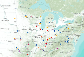
Distribution of Indigo Bunting adult captures at MAPS stations during the period 1992-2008 throughout Midwestern states (plus 250km buffer).

Breeding Bird Survey Relative Abundance for Acadian Flycatcher
Wood Thrush (Midwest) results from Midwest MAPS stations
Proportion of grassland land cover within a 5-km radius developed using a circular focal moving window analysis.
Categories: Data;
Types: Downloadable,
GeoTIFF,
Map Service,
Raster;
Tags: Colorado,
Idaho,
Montana,
United States,
Utah,
These data include egg mass counts and adult capture-mark-recapture histories for Foothill Yellow-legged frogs (Rana boylii) at two streams in northern California. Data were collected from the South Fork Eel River and its tributary, Fox Creek, from 1993-2019. Data from Hurdygurdy Creek were collected from 2002-2008.
The Forest and Rangeland Ecosystem Science Center 's mission is to provide scientific understanding and the technology needed to support sound management and conservation of our nation's natural resources, with emphasis on western ecosystems. The scientists from FRESC capitalize on their diverse expertise to answer critically important scientific questions shaped by the equally diverse environments of the western United States. FRESC scientists collaborate with each other and with partners to provide rigorous, objective, and timely information and guidance for the management and conservation of biological systems in the West and worldwide. Research activities are concentrated in Washington, Oregon, Idaho, Nevada,...
The purpose of the Conservation Effects Assessment Project (CEAP) cropland national assessment is to quantify the environmental benefits of conservation programs at the regional and national levels, which include both onsite and instream water quality benefits. Modeling is an effective tool for environmental assessment at the regional and national scale due to the complexities in nature at this scale. Two simulation models, the Agricultural Policy Environmental extender (APEX) and the Soil and Water Assessment Tool (SWAT), were used for the CEAP cropland national assessment. A subset of National Resources Inventory (NRI) sample points was selected to serve as "representative fields" for the CEAP cropland survey...
Categories: Publication;
Types: Citation;
Tags: Agriculture,
Channels,
Conservation,
Data Visualization & Tools,
ENA 06:Food & Drugs,
This dataset represents the location and class density of potential annual grass risk within the Central Great Basin and Mojave Basin Ecoregion for the 2010 time period. This model represent a composite of multiple inductive (Maximum Entropy) models of varying annual grass cover using non-spectral landscape variables. Input Variables: elevation, aspect, distance to fire, geology, distance to hydric soils, distance to intermitant streams, landform, ombrotype, distance to perrenial streams, soil pH, density of primary roads, density of secondary/local roads, percent sandy soil, slope, thermotype. Classification of Model 0-No/Low Risk 1- < 5% Cover Risk 2- 5%-15% Cover Risk 3 - 15%-25% Cover Risk 4 - 25%-45% Cover...
A region polygon dataset categorizing land in terms of ecological significance and status of protection in the Central Basin and Range (CBR) Rapid Ecoregional Assessment. This dataset identifies lands that have been identified as ecologically significant to biodiveristy but not yet legally protected (Places I - Sites of High Biodiversity), lands that have some type of protection status, often federal or state (Places II - Specially Designated Areas of Ecological and/or Cultural Value), and lands that may be ecologically significant but are managed for multiple use (Places III – Other Managed Lands).
Types: Downloadable;
Tags: BLM,
Bureau of Land Management,
CBR 2010,
Central Basin and Range,
Conservation,
The dataset represents the work of multiple states and Federal agencies as part of the US Gap Analysis and LandFire programs. Multi-season satellite imagery (Landsat ETM+) from 1999-2001 were used in conjunction with digital elevation model (DEM) derived datasets (e.g. elevation, landform) to model natural and semi-natural vegetation. The minimum mapping unit for this dataset is approximately 1 acre. Landcover classes are drawn from NatureServe's Ecological System concept. Five-hundred and fourty-four land cover classes composed of 12 cultural and 532 Natural/Semi-natural types are described. Land cover classes were mapped with a variety of techniques including decision tree classifiers, terrian modeling, inductive...
The dataset represents the work of multiple states and Federal agencies as part of the US Gap Analysis and LandFire programs. Multi-season satellite imagery (Landsat ETM+) from 1999-2001 were used in conjunction with digital elevation model (DEM) derived datasets (e.g. elevation, landform) to model natural and semi-natural vegetation. The minimum mapping unit for this dataset is approximately 1 acre. Landcover classes are drawn from NatureServe's Ecological System concept. Five-hundred and fourty-four land cover classes composed of 12 cultural and 532 Natural/Semi-natural types are described. Land cover classes were mapped with a variety of techniques including decision tree classifiers, terrian modeling, inductive...
Ecoregions denote areas of general similarity in ecosystems and in the type, quality, and quantity of environmental resources. They are designed to serve as a spatial framework for the research, assessment, management, and monitoring of ecosystems and ecosystem components. These general purpose regions are critical for structuring and implementing ecosystem management strategies across federal agencies, state agencies, and nongovernment organizations that are responsible for different types of resources within the same geographical areas. The approach used to compile this map is based on the premise that ecological regions can be identified through the analysis of patterns of biotic and abiotic phenomena, including...
The dataset represents the work of multiple states and Federal agencies as part of the US Gap Analysis and LandFire programs. Multi-season satellite imagery (Landsat ETM+) from 1999-2001 were used in conjunction with digital elevation model (DEM) derived datasets (e.g. elevation, landform) to model natural and semi-natural vegetation. The minimum mapping unit for this dataset is approximately 1 acre. Landcover classes are drawn from NatureServe's Ecological System concept. Five-hundred and fourty-four land cover classes composed of 12 cultural and 532 Natural/Semi-natural types are described. Land cover classes were mapped with a variety of techniques including decision tree classifiers, terrian modeling, inductive...
This dataset was derived from 'NatureServe L48 ESLF V2.7'. See process steps for additional information. The dataset represents the work of multiple states and Federal agencies as part of the US Gap Analysis and LandFire programs. Multi-season satellite imagery (Landsat ETM+) from 1999-2001 were used in conjunction with digital elevation model (DEM) derived datasets (e.g. elevation, landform) to model natural and semi-natural vegetation. The minimum mapping unit for this dataset is approximately 1 acre. Landcover classes are drawn from NatureServe's Ecological System concept. Five-hundred and fourty-four land cover classes composed of 12 cultural and 532 Natural/Semi-natural types are described. Land cover classes...
The Yukon North Slope is an arctic “hot spot” of climate change-induced effects with profound significance for the Inuvialuit and the larger region. In 1984, the Inuvialuit entered into a land claim agreement – the Inuvialuit Final Agreement (IFA) – with the governments of Canada, Yukon and Northwest Territories. A co-management body formed to make a plan, which was developed in 2003 but never ratified and is now considered out-of-date. Round River Conservation Studies is assisting WMAC(NS) in the collection, development and synthesis of spatial data, models and analyses of cultural and ecological values of the YNS.The project is a collaboration among the NWB LCC, Round River Conservation Studies, and the Arctic...
Categories: Data,
Project,
Publication;
Types: Citation,
Map Service,
OGC WFS Layer,
OGC WMS Layer,
OGC WMS Service;
Tags: Academics & scientific researchers,
CONSERVATION,
CONSERVATION,
CONSERVATION,
CONSERVATION,
The Yukon North Slope is an arctic “hot spot” of climate change-induced effects with profound significance for the Inuvialuit and the larger region. In 1984, the Inuvialuit entered into a land claim agreement – the Inuvialuit Final Agreement (IFA) – with the governments of Canada, Yukon and Northwest Territories. A co-management body formed to make a plan, which was developed in 2003 but never ratified and is now considered out-of-date. Round River Conservation Studies is assisting WMAC(NS) in the collection, development and synthesis of spatial data, models and analyses of cultural and ecological values of the YNS.The project is a collaboration among the NWB LCC, Round River Conservation Studies, and the Arctic...
Categories: Data,
Project;
Tags: Academics & scientific researchers,
CONSERVATION,
Conservation Design,
Conservation NGOs,
Conservation Planning,
Forest Retention Index classes for the southeastern United States at 2040 were processed using the Forest Retention Decision Tree and rendered on a 30-meter by 30-meter grid. The Forest Retention Index is used only for current forestland, identified using National Land Cover Database 2011. Many datasets were used as inputs for the Forest Retention Decision Tree, and they can be grouped into five broad categories: Protected, Tier 1 Priority, Tier 2 Priority, Threats to Forest Retention, and Socio-Economic Value of Forests. Protected datasets include Protected Areas Database-United States, National Conservation Easement Database, state-maintained databases, and private datasets volunteered by conservation partners....
Categories: Data;
Types: ArcGIS REST Map Service,
ArcGIS Service Definition,
Downloadable,
Map Service;
Tags: Alabama,
Arkansas,
Florida,
Georgia,
Illinois,
|

|
