Filters: Tags: conservation (X)
1,274 results (34ms)|
Filters
Date Range
Extensions Types Contacts
Categories Tag Types
|
Proportion of low and black sagebrush land cover within a 5-km radius developed using a circular focal moving window analysis.
Categories: Data;
Types: Downloadable,
GeoTIFF,
Map Service,
Raster,
Shapefile;
Tags: Artemisia arbuscula,
Artemisia nova,
Colorado,
Idaho,
Montana,
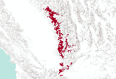
Location of mixed shrubland land cover obtained from the LANDFIRE Existing Vegetation Type dataset.
Categories: Data;
Types: Downloadable,
GeoTIFF,
Map Service,
Raster;
Tags: Colorado,
Idaho,
Montana,
United States,
Utah,
Density of all roads within a 5-km radius developed using a circular focal moving window analysis.
Categories: Data;
Types: Downloadable,
GeoTIFF,
Map Service,
Raster;
Tags: Colorado,
Idaho,
Montana,
United States,
Utah,
Proportion of all sagebrush species land cover within a 1-km radius developed using a circular focal moving window analysis.
Categories: Data;
Types: Downloadable,
GeoTIFF,
Map Service,
Raster;
Tags: Artemisia spp.,
Colorado,
Idaho,
Montana,
United States,
Proportion of salt desert shrub land cover within a 1-km radius developed using a circular focal moving window analysis.

Pacific-slope Flycatcher station lifetime productivity (STAPI) (log transformed) ranged between -0.034 and +0.606 with a mean value of +0.286 and a median value of +0.247. ________________________________________ Model 1 (3 parameters) Pacific-slope Flycatcher station lifetime productivity (STAPI) (log transformed) was a function of: a) INTERCEPT (0.3022), b) NLCD06AF90P (+0.01874) - percent all forest cover, 90m-resolution(3x aggregation of 30m-resolution), ranged between -1.901 and +6.011 (95% CL) with a mean value of +2.055 and a median value of +2.494, c) NLCD06IM33P (-0.02730) - percent impervious cover, 990m-resolution (33x aggregation of 30m-resolution), ranged between -1.057 and +5.084 (95% CL) with...

The Nature Conservancy (TNC) has derived climate suitability forecasts for most species of trees and shrubs considered to be ecological dominants of terrestrial Californian habitat types. Our plant projections are compiled as decision support tools to help Conservancy project staff, as well as our external partners, develop the necessary plans, priorities and strategies to successfully adapt to uncertain changes in future climate. In the recently completed Southern Sierra Partnership's 2010 Climate-Adapted Conservation Plan for the Southern Sierra Nevada and Tehachapi Mountains, species and habitat forecasts shown here informed the development of a regional conservation design that explicitly incorporates long-term...
The Nature Conservancy (TNC) has derived climate suitability forecasts for most species of trees and shrubs considered to be ecological dominants of terrestrial Californian habitat types. Our plant projections are compiled as decision support tools to help Conservancy project staff, as well as our external partners, develop the necessary plans, priorities and strategies to successfully adapt to uncertain changes in future climate. In the recently completed Southern Sierra Partnership's 2010 Climate-Adapted Conservation Plan for the Southern Sierra Nevada and Tehachapi Mountains, species and habitat forecasts shown here informed the development of a regional conservation design that explicitly incorporates long-term...

The Nature Conservancy (TNC) has derived climate suitability forecasts for most species of trees and shrubs considered to be ecological dominants of terrestrial Californian habitat types. Our plant projections are compiled as decision support tools to help Conservancy project staff, as well as our external partners, develop the necessary plans, priorities and strategies to successfully adapt to uncertain changes in future climate. In the recently completed Southern Sierra Partnership's 2010 Climate-Adapted Conservation Plan for the Southern Sierra Nevada and Tehachapi Mountains, species and habitat forecasts shown here informed the development of a regional conservation design that explicitly incorporates long-term...
We capitalized on a regional-scale, anthropogenic experiment?the reduction of black-tailed prairie dog (Cynomys ludovicianus) towns across the Great Plains of North America?to test the hypothesis that decline of this species has led to declines in diversity of native grassland vertebrates of this region. We compared species richness and species composition of non-volant mammals, reptiles and amphibians at 36 prairie dog towns and 36 paired sites in the Panhandle Region of Oklahoma during the summers and falls of 1997, 1998 and 1999. We detected 30 species of mammals, 18 species of reptiles and seven species of amphibians. Comparisons between communities at prairie dog towns and paired sites in the adjacent landscape...
Categories: Publication;
Types: Citation,
Journal Citation;
Tags: Biological Conservation,
Cynomys ludovicianus,
Great Plains,
Oklahoma,
amphibians,
Every production practice, including conservation tillage, has positive or negative environmental consequences that may involve air, land, water, and/or the health and ecological status of wildlife. The negative impacts associated with agricultural production, and the use of conventional tillage systems in particular, include soil erosion, energy use, leaching and runoff of agricultural chemicals, and carbon emissions. Several of these impacts are quantified. The conclusions suggest that the use of conservation tillage does result in less of an adverse impact on the environment from agricultural production than does conventional tillage by reducing surface water runoff and wind erosion. Additionally, wildlife habitat...
Energy subsidies are widespread around the world but they vary greatly in importance and type of fuel and country. The fossil fuel consumption rate is growing every year and in about 50 years we will have depleted most of our fossil fuel reserves, so it is necessary to find alternative sources of energy before that happens. However, the only solution to this challenge is through investment on energy conservation programmes and renewable energy source. In line with this challenge and confusion on fund appropriate for energy. This paper is aimed at examining the effect of energy subsidy on energy conservation and renewable energy in developing countries. The study intends to quantify and analysis a case study of Trinidad...
Categories: Publication;
Types: Citation;
Tags: Conservation,
Consumption,
Energy,
Subsidy,
Sustainability

Louisiana Waterthrush - VizBand/Land AIC Model Selection Created: 05-Oct-2011 Louisiana Waterthrush annual capture rate of adult (ADULT) individuals (log transformed) ranged between -0.220 and +2.009 with a mean value of +0.895 and a median value of +0.794. ________________________________________ Model 1 (2 parameters) Louisiana Waterthrush annual capture rate of adult (ADULT) individuals (log transformed) was a function of: a) DIST2RIV15 (-0.30142) - distance (m) to stream, ranged between -1.104 and +0.772 (95% CL) with a mean value of -0.166 and a median value of -0.121, b) NLCD06DE33P (+0.46681) - percent deciduous forest cover, 990m-resolution (33x aggregation of 30m-resolution), ranged between +1.446 and...

Nashville Warbler - VizBand/Land AIC Model Selection Created: 17-May-2011 Nashville Warbler annual capture rate of adult (ADULT) individuals (log transformed) ranged between -0.233 and +2.357 with a mean value of +1.062 and a median value of +1.045. ________________________________________ Model 1 (3 parameters) Nashville Warbler annual capture rate of adult (ADULT) individuals (log transformed) was a function of: a) NLCD06CO2KP (-0.03933) - percent coniferous forest cover, 990m-resolution in a landscape context of 2km radius, ranged between +9.653 and +23.455 (95% CL) with a mean value of +16.554 and a median value of +18.030, b) STRMNET5K (+0.04352) - stream density (percent of pixels), 990m-resolution in a landscape...

Midwest MAPS Stations that operated 4 or more years between 1992 and 2008. Stations are classified by three categories of ability to effectively monitor priority species of continental concern and whether they were active in 2011. High Medium Total number of Species Captured >=15 >=10 Mean Capture Rate of Priority Species >=0.5 >=0.4 Total Number of Priority Species >=8 >=6 Percentage of Priority Species >=20 >=10 Other stations may be directed at restoration or single species MAPS Website

Created by Congress in 1964, the Land and Water Conservation Fund (LWCF) provides money to federal, state and local governments to purchase land, water and wetlands for the the benefit of all Americans. From majestic forests and snowcapped mountains, to wild rivers and stunning beaches, these acquisitions become part of your national forests. For more information visit the LWCF website: http://www.fs.fed.us/land/staff/LWCF/

Distribution of hite-eyed Vireo mean adult day of capture at MAPS stations during the period 1992-2008 throughout Midwestern states (plus 250km buffer).

This layer was created from the U.S. Fish and Wildlife Service Landscape Conservation Cooperatives data for the purpose of serving as a mask to show only land areas covered by the South Atlantic LCC geographic area. Landscape conservation cooperatives (LCCs) are conservation-science partnerships between the U.S. Fish and Wildlife Service, U.S. Geological Survey (USGS), and other federal agencies, states, tribes, NGOs, universities and stakeholders within a geographically defined area. They inform resource management decisions to address national-scale stressors-including habitat fragmentation, genetic isolation, spread of invasive species, and water scarcity-all of which are accelerated by climate change.

The Global Human Influence Index Dataset of the Last of the Wild Project, Version 2, 2005 (LWP-2) is a global dataset of 1-kilometer grid cells, created from nine global data layers covering human population pressure (population density), human land use and infrastructure (built-up areas, nighttime lights, land use/land cover), and human access (coastlines, roads, railroads, navigable rivers). The dataset is produced by the Wildlife Conservation Society (WCS) and the Columbia University Center for International Earth Science Information Network (CIESIN). The Human Influence Index (HII) is a measure of direct human influence on terrestrial ecosystems using the best available data sets on human settlement (population...
Implementation of the U.S. Department of Agriculture (USDA) Conservation Reserve Program (CRP) and Wetlands Reserve Program (WRP) has resulted in the restoration of >2 million ha of wetland and grassland habitats in the Prairie Pothole Region (PPR). Restoration of habitats through these programs provides diverse ecosystem services to society, but few investigators have evaluated the environmental benefits achieved by these programs. We describe changes in wetland processes, functions, and ecosystem services that occur when wetlands and adjacent uplands on agricultural lands are restored through Farm Bill conservation programs. At the scale of wetland catchments, projects have had positive impacts on water storage,...
Categories: Publication;
Types: Citation;
Tags: carbon,
conservation,
ecosystem services,
grasslands,
prairie potholes,
|

|
