Filters: Tags: drainage (X)
102 results (203ms)|
Filters
Date Range
Extensions Types Contacts
Categories Tag Types
|

HydroSHEDS (Hydrological data and maps based on SHuttle Elevation Derivatives at multiple Scales) provides hydrographic information in a consistent and comprehensive format for regional and global-scale applications. HydroSHEDS offers a suite of geo-referenced data sets (vector and raster), including stream networks, watershed boundaries, drainage directions, and ancillary data layers such as flow accumulations, distances, and river topology information. HydroSHEDS is derived from elevation data of the Shuttle Radar Topography Mission (SRTM) at 3 arc-second resolution. Available HydroSHEDS resolutions range from 3 arc-second (approx. 90 meters at the equator) to 5 minute (approx. 10 km at the equator) with seamless...

HydroSHEDS (Hydrological data and maps based on SHuttle Elevation Derivatives at multiple Scales) provides hydrographic information in a consistent and comprehensive format for regional and global-scale applications. HydroSHEDS offers a suite of geo-referenced data sets (vector and raster), including stream networks, watershed boundaries, drainage directions, and ancillary data layers such as flow accumulations, distances, and river topology information. HydroSHEDS is derived from elevation data of the Shuttle Radar Topography Mission (SRTM) at 3 arc-second resolution. Available HydroSHEDS resolutions range from 3 arc-second (approx. 90 meters at the equator) to 5 minute (approx. 10 km at the equator) with seamless...

HydroSHEDS (Hydrological data and maps based on SHuttle Elevation Derivatives at multiple Scales) provides hydrographic information in a consistent and comprehensive format for regional and global-scale applications. HydroSHEDS offers a suite of geo-referenced data sets (vector and raster), including stream networks, watershed boundaries, drainage directions, and ancillary data layers such as flow accumulations, distances, and river topology information. HydroSHEDS is derived from elevation data of the Shuttle Radar Topography Mission (SRTM) at 3 arc-second resolution. Available HydroSHEDS resolutions range from 3 arc-second (approx. 90 meters at the equator) to 5 minute (approx. 10 km at the equator) with seamless...

This dataset represents the soil hydrologic group from SSURGO and STATSGO soil descriptions for soil map units in the state of southern Alaska that lie within the North Pacific Landscape Conservation Cooperative. Definition The complete definition and official criteria for hydrologic soil groups are available online at (Title 210, National Engineering Handbook, Part 630, Chapter 7, “Hydrologic Soil Groups”). “Hydrologic group” is a group of soils having similar runoff potential under similar storm and cover conditions. Soil properties that influence runoff potential are those that influence the minimum rate of infiltration for a bare soil after prolonged wetting and when not frozen. These properties are depth...

This dataset represents the soil hydrologic group from SSURGO and STATSGO soil descriptions for soil map units in the state of northern California that lie within the North Pacific Landscape Conservation Cooperative. Definition The complete definition and official criteria for hydrologic soil groups are available online at (Title 210, National Engineering Handbook, Part 630, Chapter 7, “Hydrologic Soil Groups”). “Hydrologic group” is a group of soils having similar runoff potential under similar storm and cover conditions. Soil properties that influence runoff potential are those that influence the minimum rate of infiltration for a bare soil after prolonged wetting and when not frozen. These properties are...
Field surveys were conducted during 1997 and 1998 documenting the distribution and abundance of Colorado River cutthroat trout (Oncorhynchus clarki pleuriticus) in Escalante River tributaries. This documented occurrence of native trout in the Escalante River drainage of southern Utah represents an expansion of the known historic range of this subspecies as reported before the 1990s. We found 5 populations of native trout ranging in biomass from 3.0 to 104.2 kg ha-1 and occupying 13.2 km of stream of 130 km of estimated historic habitat. Current distribution and abundance of Colorado River cutthroat trout were compared to early introductions of nonnative trout stocked for sport fishing purposes. Native cutthroat...
Categories: Publication;
Types: Citation,
Journal Citation;
Tags: Colorado River,
Escalange River,
Western North American Naturalist,
abundance,
cutthroat trout,

U.S. Geological Survey, Department of the Interior - The annual Watershed Boundary Dataset (WBD) stewardship plan is to maintain watershed boundary data through usage of WBD edit tools over the United States and its territories. WBD for the nation has been collected and is now in maintenance mode. Interested parties who wish to become a stewardship partner with the USGS in FY15 or in future years should contact a USGS Geospatial Liaison - http://liaisons.usgs.gov/geospatial/documents/TNM_Partnership_User_ContactList.pdf. To find out more about watershed boundary stewardship go to http://nhd.usgs.gov/wbd.html or http://nhd.usgs.gov/WBDstewardshipInfoSheet.pdf
Excess phosphorus (P) in freshwater systems has been associated with eutrophication in agro-ecosystems of the US Midwest and elsewhere. A better understanding of processes regulating both soluble reactive phosphorus (SRP) and total phosphorus (TP) exports to tile-drains is therefore critical to minimize P losses to streams while maintaining crop yield. This paper investigates SRP and TP dynamics at a high temporal resolution during four spring storms in two tile-drains in the US Midwest. Depending on the storm, median concentrations varied between 0.006–0.025 mg/L for SRP and 0.057–0.176 mg/L for TP. For large storms (>6 cm bulk precipitation), for which macropore flow represented between 43 and 50% of total tile-drain...
Categories: Publication;
Types: Citation;
Tags: Data Visualization & Tools,
Drainage,
Landscapes,
Macropore flow,
Matrix flow,
This represents the flowline network in Western Lale Erie Restoration Assessment (WLERA). It is attributed with the number of disconnections between the reach and the connecting river system. These data will help identify the condition of hydrologic separation between potential restoration areas and the connecting river system. Low numbers represent fewer disconnections such as culverts between the reach and the rivers requiring no flow network modification to restore the area.
Categories: Data;
Types: Citation,
Downloadable,
Map Service,
OGC WFS Layer,
OGC WMS Layer,
Shapefile;
Tags: Artificial Path,
Canal / Ditch,
FWHydrography,
Great Lakes,
Hydrography,
Map of the Hulahula River Area and location of observation sites. This focal watershed provides the greatest opportunity to characterize conditions within and fluxes from the Brooks Range Ecoregion. Though the Foothills region isextensive, the watersheds narrow as they cross the Coastal Plain in the easternpart of the North Slope. Inset shows the location of the seven TEON focal watersheds. Image by Arctic LCC staff.
Categories: Data;
Types: Map Service,
OGC WFS Layer,
OGC WMS Layer,
OGC WMS Service;
Tags: AIR TEMPERATURE,
AIR TEMPERATURE,
ATMOSPHERE,
ATMOSPHERE,
Academics & scientific researchers,
The Yukon-Kuskokwim Delta (YKD) encompasses the southernmost, warmest parts of the arctic tundra biome and is renowned for its high biological productivity and large subsistence-based human population. Ice-rich permafrost currently is widespread and strongly influences terrestrial and aquatic habitats, including local topography, vegetation, soil hydrology, and the water balance of lakes. Ground temperatures are near the freezing point, however, and recent projections indicate that the YKD is poised for widespread loss of permafrost by the end of this century. This has implications for the region’s extensive and heretofore stable terrestrial and aquatic habitats. Tundra wildfire is a common ecological “pulse” disturbance...
Categories: Data,
Project;
Types: Map Service,
OGC WFS Layer,
OGC WMS Layer,
OGC WMS Service;
Tags: 2016,
AK-00,
Academics & scientific researchers,
Academics & scientific researchers,
Conservation NGOs,

This geodatabase contains streams, waterbodies and wetlands, streamflow gaging stations, and coastlines for the United States, Puerto Rico, and the U.S. Virgin Islands. The streams are incorporated into a geometric network. All feature classes are vertically integrated with each other and with 1:1,000,000-scale transportation and boundary data sets.

HydroSHEDS (Hydrological data and maps based on SHuttle Elevation Derivatives at multiple Scales) provides hydrographic information in a consistent and comprehensive format for regional and global-scale applications. HydroSHEDS offers a suite of geo-referenced data sets (vector and raster), including stream networks, watershed boundaries, drainage directions, and ancillary data layers such as flow accumulations, distances, and river topology information. HydroSHEDS is derived from elevation data of the Shuttle Radar Topography Mission (SRTM) at 3 arc-second resolution. Available HydroSHEDS resolutions range from 3 arc-second (approx. 90 meters at the equator) to 5 minute (approx. 10 km at the equator) with seamless...

HydroSHEDS (Hydrological data and maps based on SHuttle Elevation Derivatives at multiple Scales) provides hydrographic information in a consistent and comprehensive format for regional and global-scale applications. HydroSHEDS offers a suite of geo-referenced data sets (vector and raster), including stream networks, watershed boundaries, drainage directions, and ancillary data layers such as flow accumulations, distances, and river topology information. HydroSHEDS is derived from elevation data of the Shuttle Radar Topography Mission (SRTM) at 3 arc-second resolution. Available HydroSHEDS resolutions range from 3 arc-second (approx. 90 meters at the equator) to 5 minute (approx. 10 km at the equator) with seamless...

HydroSHEDS (Hydrological data and maps based on SHuttle Elevation Derivatives at multiple Scales) provides hydrographic information in a consistent and comprehensive format for regional and global-scale applications. HydroSHEDS offers a suite of geo-referenced data sets (vector and raster), including stream networks, watershed boundaries, drainage directions, and ancillary data layers such as flow accumulations, distances, and river topology information. HydroSHEDS is derived from elevation data of the Shuttle Radar Topography Mission (SRTM) at 3 arc-second resolution. Available HydroSHEDS resolutions range from 3 arc-second (approx. 90 meters at the equator) to 5 minute (approx. 10 km at the equator) with seamless...
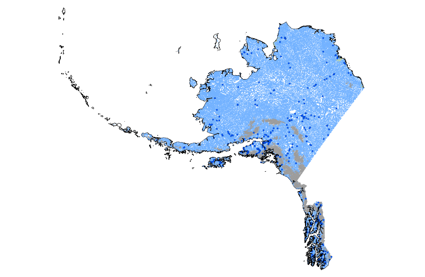
This geodatabase contains streams, waterbodies and wetlands, streamflow gaging stations, and coastlines for Alaska. The streams are incorporated into a geometric network. All feature classes are vertically integrated with each other and with 1:1,000,000-scale transportation and boundary data sets.
Map of the Agashashok River Area and location of proposed observation sites (numbered circles). This focal watershed is in the southwest corner of the Arctic LCC and largely drains the Brooks Range ecoregion with a small portion of the lower basin in the Kobuk Ridges and Valleys ecoregion. The braided character of the lower river prevents us from suggesting a long term gaging station in that location. Inset shows the location of the seven TEON focal watersheds. Image by Arctic LCC staff.
Categories: Data;
Types: Map Service,
OGC WFS Layer,
OGC WMS Layer,
OGC WMS Service;
Tags: AIR TEMPERATURE,
AIR TEMPERATURE,
ATMOSPHERE,
ATMOSPHERE,
Academics & scientific researchers,
This is a release of data presented in the report "Binational Study of the Transboundary San Pedro Aquifer", Callegary and others, 2016: Callegary, J.B., Minjárez Sosa, I., Tapia Villaseñor, E.M., dos Santos, P., Monreal Saavedra, R., Grijalva Noriega, F.J., Huth, A.K., Gray, F., Scott, C.A., Megdal, S.B., Oroz Ramos, L.A., Rangel Medina, M., Leenhouts, J.M., 2016, Binational Study of the Transboundary San Pedro Aquifer: International Boundary and Water Commission. The United States and Mexico share waters in a number of hydrological basins and aquifers that cross the International Boundary. Both the United States and Mexico recognize that, in a region of scarce water and expanding populations, better...

HydroSHEDS (Hydrological data and maps based on SHuttle Elevation Derivatives at multiple Scales) provides hydrographic information in a consistent and comprehensive format for regional and global-scale applications. HydroSHEDS offers a suite of geo-referenced data sets (vector and raster), including stream networks, watershed boundaries, drainage directions, and ancillary data layers such as flow accumulations, distances, and river topology information. HydroSHEDS is derived from elevation data of the Shuttle Radar Topography Mission (SRTM) at 3 arc-second resolution. Available HydroSHEDS resolutions range from 3 arc-second (approx. 90 meters at the equator) to 5 minute (approx. 10 km at the equator) with seamless...

HydroSHEDS (Hydrological data and maps based on SHuttle Elevation Derivatives at multiple Scales) provides hydrographic information in a consistent and comprehensive format for regional and global-scale applications. HydroSHEDS offers a suite of geo-referenced data sets (vector and raster), including stream networks, watershed boundaries, drainage directions, and ancillary data layers such as flow accumulations, distances, and river topology information. HydroSHEDS is derived from elevation data of the Shuttle Radar Topography Mission (SRTM) at 3 arc-second resolution. Available HydroSHEDS resolutions range from 3 arc-second (approx. 90 meters at the equator) to 5 minute (approx. 10 km at the equator) with seamless...
|

|
