Filters: Tags: drainage basins (X)
321 results (1.8s)|
Filters
Date Range
Extensions Types Contacts
Categories Tag Types
|
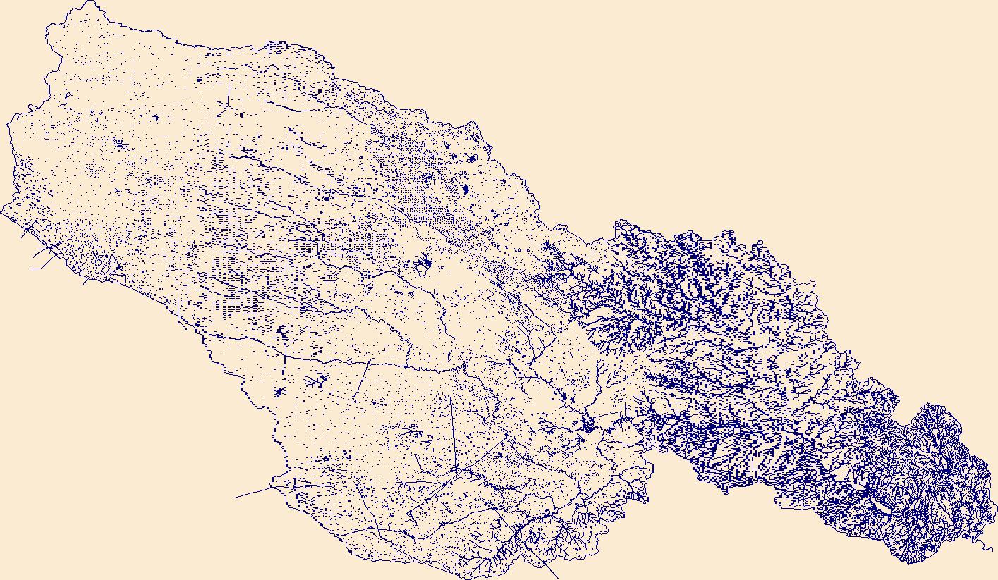
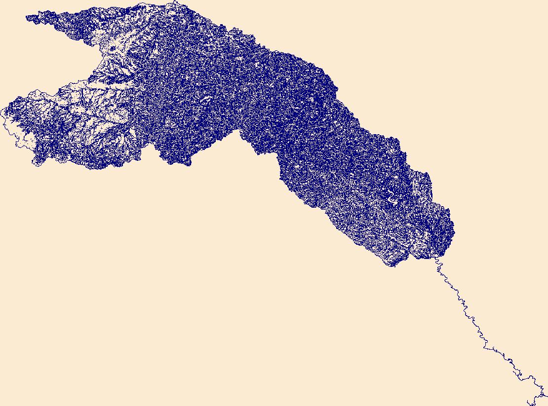
The High Resolution National Hydrography Dataset Plus (NHDPlus HR) is an integrated set of geospatial data layers, including the best available National Hydrography Dataset (NHD), the 10-meter 3D Elevation Program Digital Elevation Model (3DEP DEM), and the National Watershed Boundary Dataset (WBD). The NHDPlus HR combines the NHD, 3DEP DEMs, and WBD to create a stream network with linear referencing, feature naming, "value added attributes" (VAAs), elevation-derived catchments, and other features for hydrologic data analysis. The stream network with linear referencing is a system of data relationships applied to hydrographic systems so that one stream reach "flows" into another and "events" can be tied to and traced...
The High Resolution National Hydrography Dataset Plus (NHDPlus HR) is an integrated set of geospatial data layers, including the best available National Hydrography Dataset (NHD), the 10-meter 3D Elevation Program Digital Elevation Model (3DEP DEM), and the National Watershed Boundary Dataset (WBD). The NHDPlus HR combines the NHD, 3DEP DEMs, and WBD to create a stream network with linear referencing, feature naming, "value added attributes" (VAAs), elevation-derived catchments, and other features for hydrologic data analysis. The stream network with linear referencing is a system of data relationships applied to hydrographic systems so that one stream reach "flows" into another and "events" can be tied to and traced...

These data were released prior to the October 1, 2016 effective date for the USGS’s policy dictating the review, approval, and release of scientific data as referenced in USGS Survey Manual Chapter 502.8 Fundamental Science Practices: Review and Approval of Scientific Data for Release. This data set consists of digital water-table contours for the Morongo Basin. The U.S. Geological Survey constructed a water-table map of the Morongo ground-water basin for ground-water levels measured during the period January-October 1994. Water-level data were collected from 248 wells to construct the contours. The water-table contours were digitized from the paper map which was published at a scale of 1:125,000. The contour interval...
This data release is currently being revised and is temporarily unavailable. Digital datasets were used to develop basin characteristics whose values are used in multiple regression equations and tested for the use in predicting flow-duration curves (FDCs) in ungaged areas of Illinois and Indiana. Several basin characteristics are easily derived from StreamStats (https://streamstats.usgs.gov/ss/) basin delineations themselves, such as basin area and basin centroid. Other basin characteristics require ancillary datasets as input. The data provided through this data release are those data that have been collected, tested, and ultimately selected as a basis for FDC development. These include Soil Components (Available...
Categories: Data Release - Revised;
Tags: Basin characteristic,
Flow-duration curve,
Hydrology,
Illinois,
Indiana,
This file contains the boundary for the Lahontan cutthroat trout (LCT) Geographic Management Units (GMU). The USDA Watershed boundary dataset was used to delineate the GMU boundary.
Amphibians are among the most sensitive taxa to climate change, and species inhabiting arid and semiarid landscapes at the extremes of their range are especially vulnerable to periods of drought. The Jack Creek, Oregon, USA population of Oregon spotted frogs (Rana pretiosa) faces unique challenges occupying the highest elevation site in the species’ extant range and one that has been hydrologically transformed by loss of American beaver (Castor canadensis). We evaluated the effect of drought mitigation (addition of excavated ponds) on relationships between local water availability, legacy beaver dams, and R. pretiosa population dynamics in the Jack Creek system. We conducted capture-mark-recapture sampling at a...

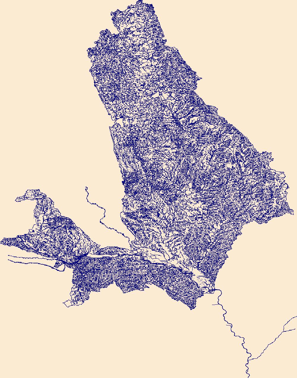
The High Resolution National Hydrography Dataset Plus (NHDPlus HR) is an integrated set of geospatial data layers, including the best available National Hydrography Dataset (NHD), the 10-meter 3D Elevation Program Digital Elevation Model (3DEP DEM), and the National Watershed Boundary Dataset (WBD). The NHDPlus HR combines the NHD, 3DEP DEMs, and WBD to create a stream network with linear referencing, feature naming, "value added attributes" (VAAs), elevation-derived catchments, and other features for hydrologic data analysis. The stream network with linear referencing is a system of data relationships applied to hydrographic systems so that one stream reach "flows" into another and "events" can be tied to and traced...
The High Resolution National Hydrography Dataset Plus (NHDPlus HR) is an integrated set of geospatial data layers, including the best available National Hydrography Dataset (NHD), the 10-meter 3D Elevation Program Digital Elevation Model (3DEP DEM), and the National Watershed Boundary Dataset (WBD). The NHDPlus HR combines the NHD, 3DEP DEMs, and WBD to create a stream network with linear referencing, feature naming, "value added attributes" (VAAs), elevation-derived catchments, and other features for hydrologic data analysis. The stream network with linear referencing is a system of data relationships applied to hydrographic systems so that one stream reach "flows" into another and "events" can be tied to and traced...
The High Resolution National Hydrography Dataset Plus (NHDPlus HR) is an integrated set of geospatial data layers, including the best available National Hydrography Dataset (NHD), the 10-meter 3D Elevation Program Digital Elevation Model (3DEP DEM), and the National Watershed Boundary Dataset (WBD). The NHDPlus HR combines the NHD, 3DEP DEMs, and WBD to create a stream network with linear referencing, feature naming, "value added attributes" (VAAs), elevation-derived catchments, and other features for hydrologic data analysis. The stream network with linear referencing is a system of data relationships applied to hydrographic systems so that one stream reach "flows" into another and "events" can be tied to and traced...
This dataset describes the location of channel heads survyed in two headwater watersheds in Clarksburg, Montgomery County, Maryland, and the digital elevation models derived from light detection and ranging (lidar) covering the two watersheds. The digital elevation models were used to derive topographic attributes used to delineate drainage networks that were then assessed for accuracy using the field-surveyed channel heads. First posted - January 21, 2021 (available from author) Revised - October 15, 2021 (version 2.0)
Categories: Data,
Data Release - Revised;
Types: Map Service,
OGC WFS Layer,
OGC WMS Layer,
OGC WMS Service;
Tags: Maryland,
USGS Science Data Catalog (SDC),
drainage basins,
land surveying,
river systems,
Human impacts occurring throughout the Northeast and Midwest United States, including urbanization, agriculture, and dams, have multiple effects on the region’s streams which support economically valuable stream fishes. Changes in climate are expected to lead to additional impacts in stream habitats and fish assemblages in multiple ways, including changing stream water temperatures. To manage streams for current impacts and future changes, managers need region-wide information for decision-making and developing proactive management strategies. Our project met that need by integrating results of a current condition assessment of stream habitats based on fish response to human land use, water quality impairment,...
Categories: Data;
Types: Citation;
Tags: Aquatic Biology,
Aquatic habitats,
Connecticut,
Data Visualization & Tools,
Delaware,
These data were released prior to the October 1, 2016 effective date for the USGS’s policy dictating the review, approval, and release of scientific data as referenced in USGS Survey Manual Chapter 502.8 Fundamental Science Practices: Review and Approval of Scientific Data for Release. This file contains hydrologic unit boundaries and codes for the conterminous United States along with Alaska, Hawaii, Puerto Rico and the U.S. Virgin Islands. It was revised for inclusion in the National Atlas of the United States of America, and updated to match the streams file created by the USGS National Mapping Division (NMD) for the National Atlas of the United States of America. For the most current data and information relating...
Categories: pre-SM502.8;
Tags: Alaska,
Cataloging Units,
Drainage Basins,
Hawaii,
Hydrologic Unit Boundaries,
This CSV file contains landscape factors representing anthropogenic disturbances to stream habitats summarized within local and network stream catchments as well as the downstream main channel catchment perennial and intermittent stream reaches of the five main islands of Hawai'i. The source datasets compiled and attributed to spatial units were identified as being: (1) meaningful for assessing fluvial fish habitat; (2) consistent across the entire study area in the way that they were assembled; (3) broadly representative of conditions in the past 10 years, and (4) of sufficient spatial resolution that they could be used to make valid comparisons among local catchment units. Variables summarized at the catchment...
Categories: Data;
Tags: 2015 National Assessment,
2015 National Assessment,
Anthropogenic factors,
DataProduct,
Environmental condition,

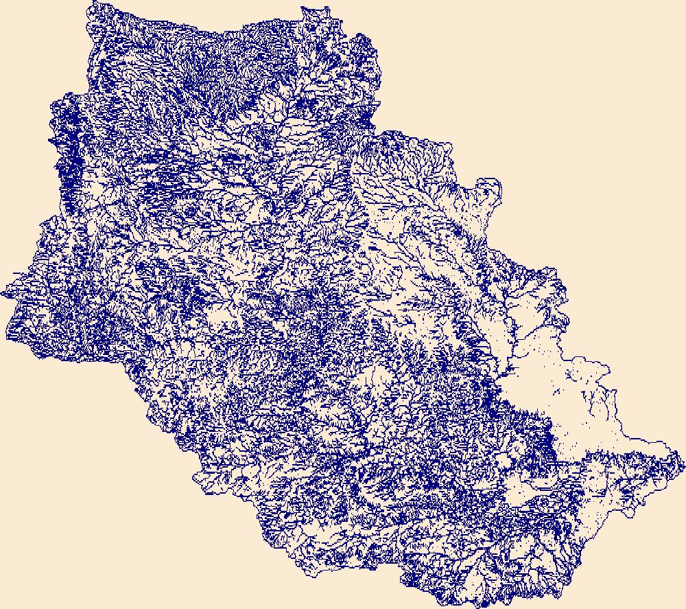
The High Resolution National Hydrography Dataset Plus (NHDPlus HR) is an integrated set of geospatial data layers, including the National Hydrography Dataset (NHD), National Watershed Boundary Dataset (WBD), and 3D Elevation Program Digital Elevation Model (3DEP DEM). The NHDPlus HR combines the NHD, 3DEP DEMs, and WBD to a data suite that includes the NHD stream network with linear referencing functionality, the WBD hydrologic units, elevation-derived catchment areas for each stream segment, "value added attributes" (VAAs), and other features that enhance hydrologic data analysis and routing.
The High Resolution National Hydrography Dataset Plus (NHDPlus HR) is an integrated set of geospatial data layers, including the best available National Hydrography Dataset (NHD), the 10-meter 3D Elevation Program Digital Elevation Model (3DEP DEM), and the National Watershed Boundary Dataset (WBD). The NHDPlus HR combines the NHD, 3DEP DEMs, and WBD to create a stream network with linear referencing, feature naming, "value added attributes" (VAAs), elevation-derived catchments, and other features for hydrologic data analysis. The stream network with linear referencing is a system of data relationships applied to hydrographic systems so that one stream reach "flows" into another and "events" can be tied to and traced...
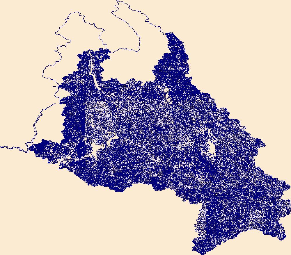
The High Resolution National Hydrography Dataset Plus (NHDPlus HR) is an integrated set of geospatial data layers, including the best available National Hydrography Dataset (NHD), the 10-meter 3D Elevation Program Digital Elevation Model (3DEP DEM), and the National Watershed Boundary Dataset (WBD). The NHDPlus HR combines the NHD, 3DEP DEMs, and WBD to create a stream network with linear referencing, feature naming, "value added attributes" (VAAs), elevation-derived catchments, and other features for hydrologic data analysis. The stream network with linear referencing is a system of data relationships applied to hydrographic systems so that one stream reach "flows" into another and "events" can be tied to and traced...

The High Resolution National Hydrography Dataset Plus (NHDPlus HR) is an integrated set of geospatial data layers, including the National Hydrography Dataset (NHD), National Watershed Boundary Dataset (WBD), and 3D Elevation Program Digital Elevation Model (3DEP DEM). The NHDPlus HR combines the NHD, 3DEP DEMs, and WBD to a data suite that includes the NHD stream network with linear referencing functionality, the WBD hydrologic units, elevation-derived catchment areas for each stream segment, "value added attributes" (VAAs), and other features that enhance hydrologic data analysis and routing.
The High Resolution National Hydrography Dataset Plus (NHDPlus HR) is an integrated set of geospatial data layers, including the best available National Hydrography Dataset (NHD), the 10-meter 3D Elevation Program Digital Elevation Model (3DEP DEM), and the National Watershed Boundary Dataset (WBD). The NHDPlus HR combines the NHD, 3DEP DEMs, and WBD to create a stream network with linear referencing, feature naming, "value added attributes" (VAAs), elevation-derived catchments, and other features for hydrologic data analysis. The stream network with linear referencing is a system of data relationships applied to hydrographic systems so that one stream reach "flows" into another and "events" can be tied to and traced...
|

|
