Filters
Date Range
Extensions
Types
Contacts
Categories
Tag Types
Tag Schemes
|

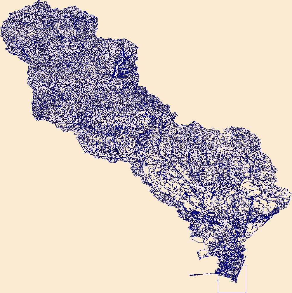
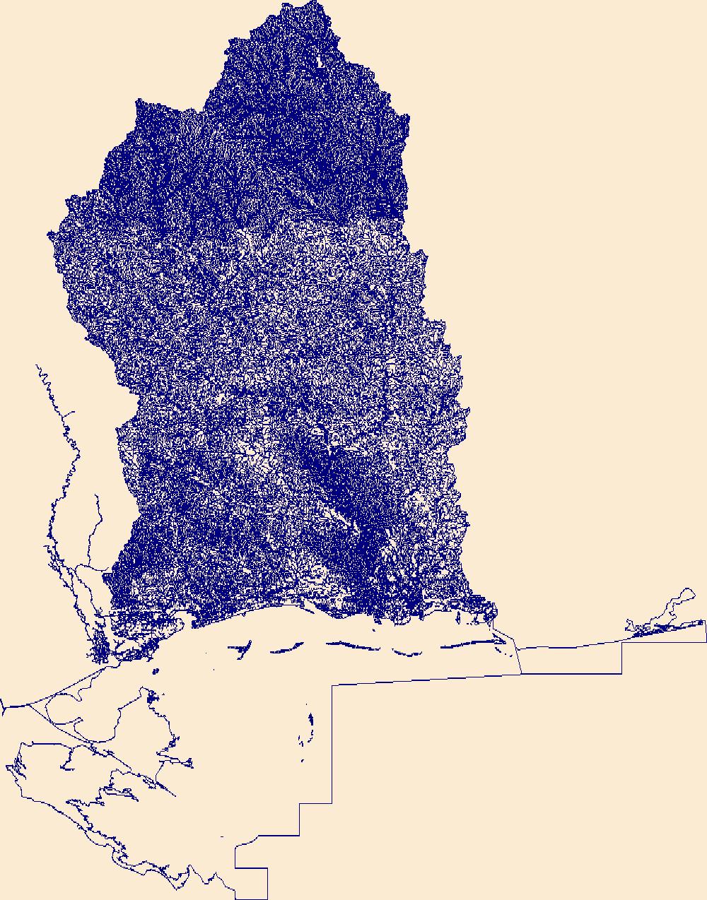
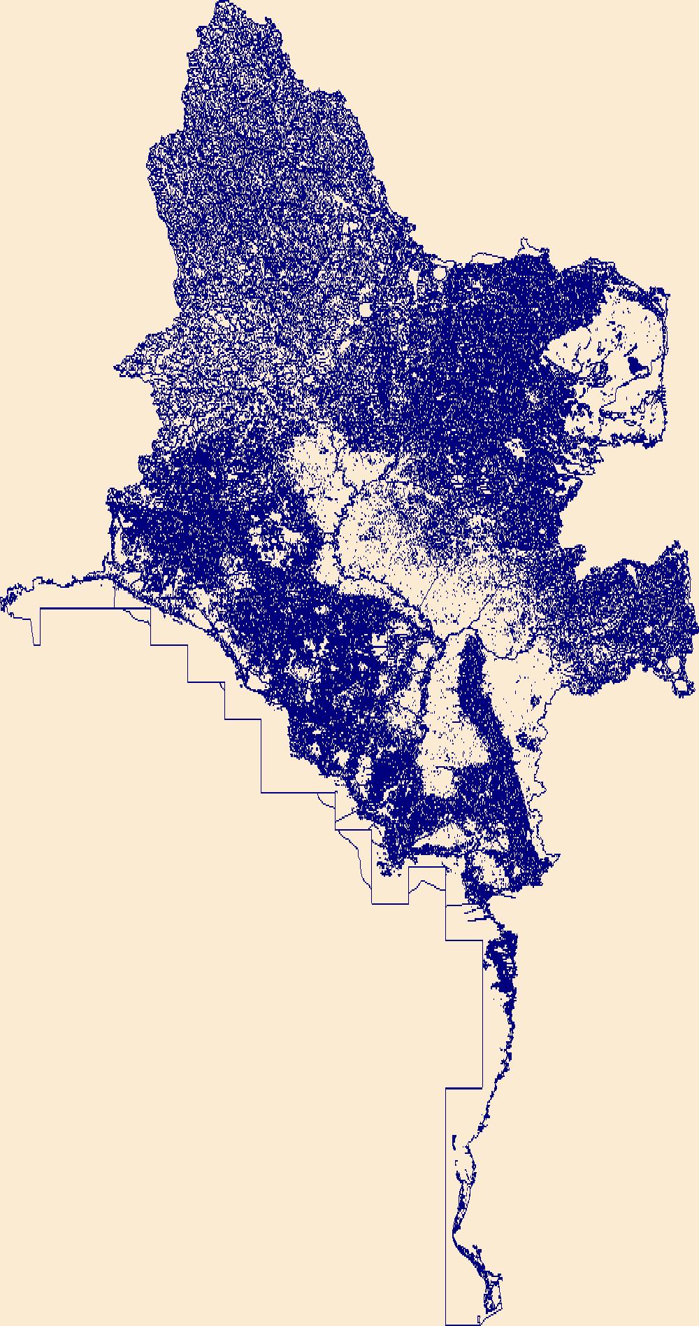
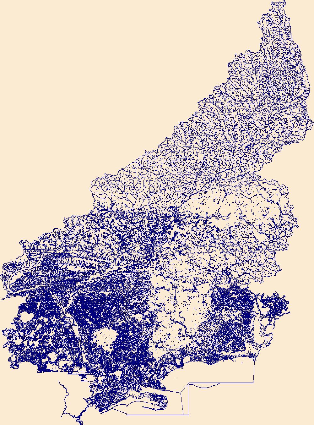
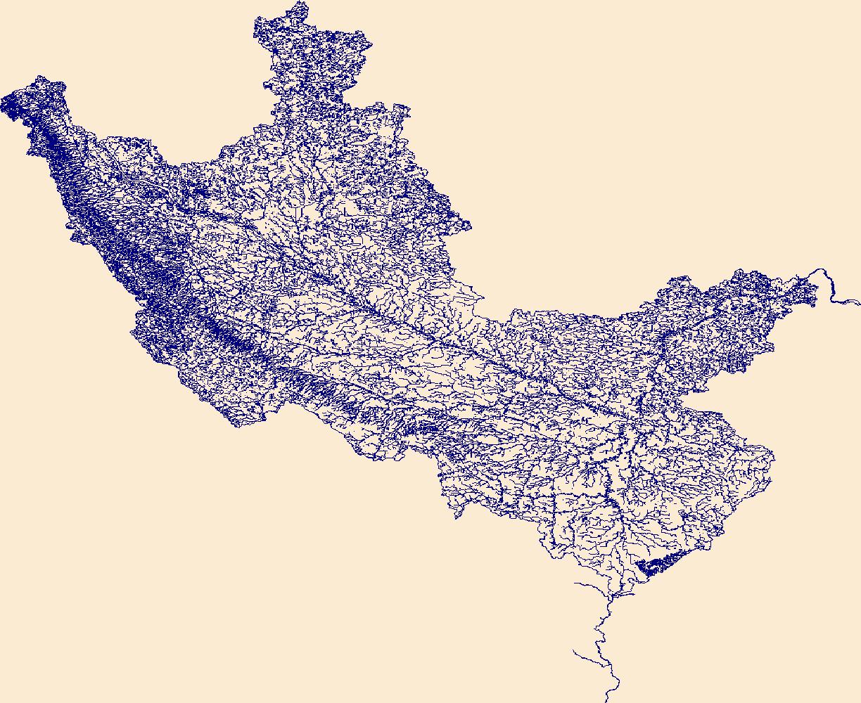
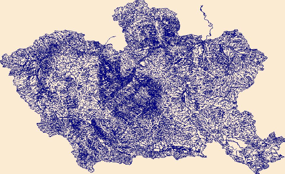
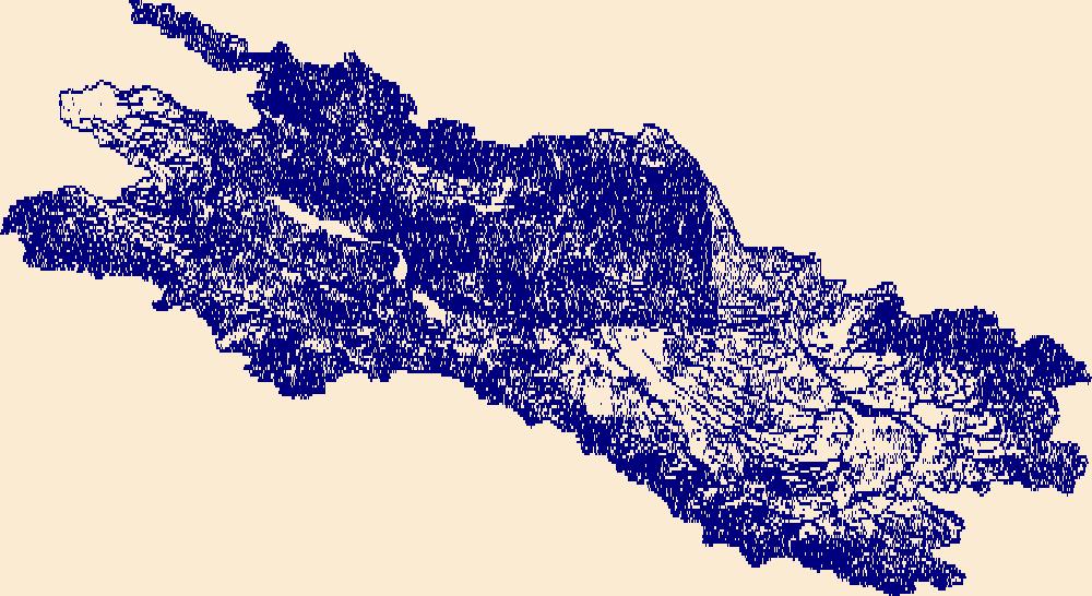
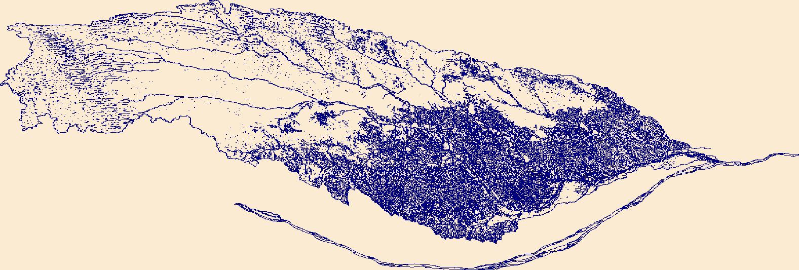
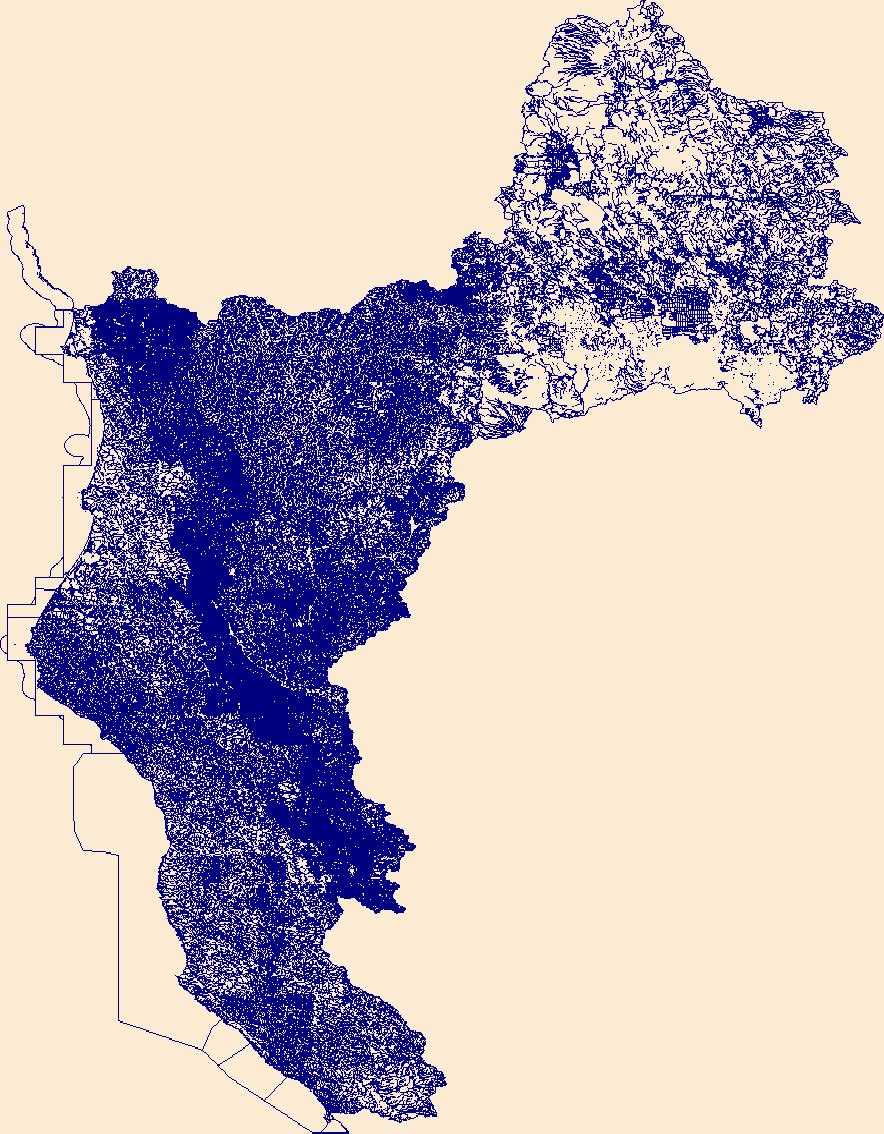
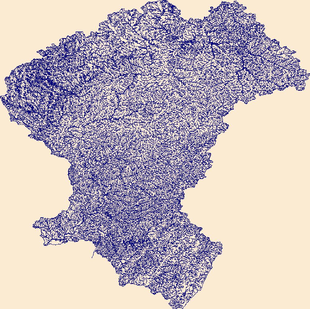
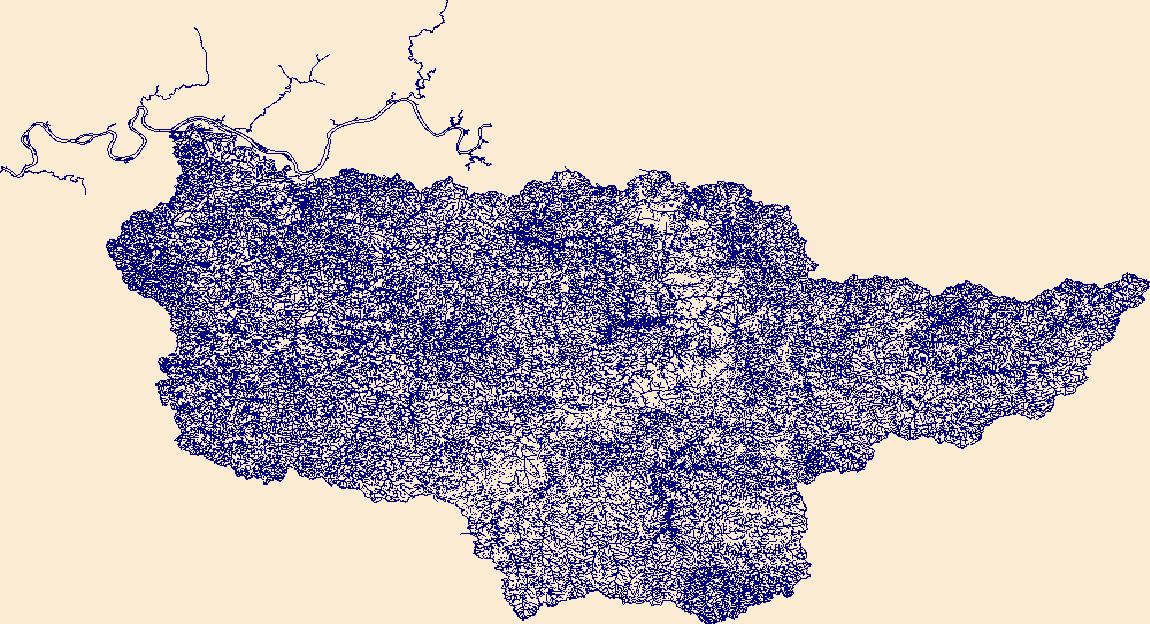
The High Resolution National Hydrography Dataset Plus (NHDPlus HR) is an integrated set of geospatial data layers, including the best available National Hydrography Dataset (NHD), the 10-meter 3D Elevation Program Digital Elevation Model (3DEP DEM), and the National Watershed Boundary Dataset (WBD). The NHDPlus HR combines the NHD, 3DEP DEMs, and WBD to create a stream network with linear referencing, feature naming, "value added attributes" (VAAs), elevation-derived catchments, and other features for hydrologic data analysis. The stream network with linear referencing is a system of data relationships applied to hydrographic systems so that one stream reach "flows" into another and "events" can be tied to and traced...
Tags: Alger County,
Ashland County,
Baraga County,
Bayfield County,
Chippewa County, All tags...
Cook County,
Douglas County,
Downloadable Data,
FileGDB,
FileGDB 10.1,
Gogebic County,
HU-4 Subregion,
HU-4 Subregion,
HU4_0418,
Houghton County,
Hydrography,
Iron County,
Keweenaw County,
Lake County,
Luce County,
MI,
MN,
Marquette County,
Michigan,
Minnesota,
NHDPlus HR Rasters,
NHDPlus High Resolution (NHDPlus HR),
National Hydrography Dataset (NHD),
National Hydrography Dataset Plus High Resolution (NHDPlus HR),
National Hydrography Dataset Plus High Resolution (NHDPlus HR) Current,
Ontonagon County,
St. Louis County,
US,
United States,
WI,
Wisconsin,
base maps,
cartography,
catchments,
channels,
digital elevation models,
drainage basins,
earth sciences,
elevation,
environment,
geographic information systems,
geoscientific,
geospatial analysis,
hydrographic datasets,
hydrographic features,
hydrology,
imagery,
inland waters,
lakes,
land surface characteristics,
reservoirs,
river reaches,
rivers,
streamflow,
streamflow data,
streams,
topography,
water bodies,
water quality,
water resources,
watersheds, Fewer tags

The High Resolution National Hydrography Dataset Plus (NHDPlus HR) is an integrated set of geospatial data layers, including the best available National Hydrography Dataset (NHD), the 10-meter 3D Elevation Program Digital Elevation Model (3DEP DEM), and the National Watershed Boundary Dataset (WBD). The NHDPlus HR combines the NHD, 3DEP DEMs, and WBD to create a stream network with linear referencing, feature naming, "value added attributes" (VAAs), elevation-derived catchments, and other features for hydrologic data analysis. The stream network with linear referencing is a system of data relationships applied to hydrographic systems so that one stream reach "flows" into another and "events" can be tied to and traced...
Tags: Attala County,
Choctaw County,
Copiah County,
Downloadable Data,
FileGDB, All tags...
FileGDB 10.1,
HU-4 Subregion,
HU-4 Subregion,
HU4_0318,
Hancock County,
Hinds County,
Hydrography,
Jefferson Davis County,
Kemper County,
LA,
Lamar County,
Lawrence County,
Leake County,
Lincoln County,
Louisiana,
MS,
Madison County,
Marion County,
Mississippi,
NHDPlus HR Rasters,
NHDPlus High Resolution (NHDPlus HR),
National Hydrography Dataset (NHD),
National Hydrography Dataset Plus High Resolution (NHDPlus HR),
National Hydrography Dataset Plus High Resolution (NHDPlus HR) Current,
Neshoba County,
Newton County,
Noxubee County,
Pearl River County,
Pike County,
Rankin County,
Scott County,
Simpson County,
Smith County,
St. Tammany County,
Tangipahoa County,
US,
United States,
Walthall County,
Washington County,
Winston County,
base maps,
cartography,
catchments,
channels,
digital elevation models,
drainage basins,
earth sciences,
elevation,
environment,
geographic information systems,
geoscientific,
geospatial analysis,
hydrographic datasets,
hydrographic features,
hydrology,
imagery,
inland waters,
lakes,
land surface characteristics,
reservoirs,
river reaches,
rivers,
streamflow,
streamflow data,
streams,
topography,
water bodies,
water quality,
water resources,
watersheds, Fewer tags

This geodatabase reflects the U.S. Geological Survey’s (USGS) ongoing commitment to its mission of understanding the nature and distribution of global mineral commodity supply chains by updating and publishing the georeferenced locations of mineral commodity production and processing facilities, mineral exploration and development sites, and mineral commodity exporting ports in Africa. The geodatabase and geospatial data layers serve to create a new geographic information product in the form of a geospatial portable document format (PDF) map. The geodatabase contains data layers from USGS, foreign governmental, and open-source sources as follows: (1) mineral production and processing facilities, (2) mineral exploration...
Tags: Africa,
Algeria,
Angola,
Benin,
Botswana, All tags...
Burkina Faso,
Burundi,
Cameroon,
Cape Verde,
Central African Republic,
Chad,
Congo,
Congo (Democratic Republic of the),
Cote D'Ivoire,
Data Release,
Djibouti,
Economic Geology,
Egypt,
Electric Power,
Electric Transmission Lines,
Energy Resources,
Equatorial Guinea,
Eritrea,
Eswatini,
Ethiopia,
Gabon,
Gambia, The,
Geography,
Ghana,
Guinea,
Guinea-Bissau,
Information Sciences,
Kenya,
Lesotho,
Liberia,
Libya,
Madagascar,
Malawi,
Mali,
Mauritania,
Mauritius,
Mineral Commodities,
Mineral Commodity,
Mineral Exploration,
Mineral Resources,
Morocco,
Mozambique,
Namibia,
Niger,
Nigeria,
Oil and Gas Pipelines,
Petroleum Product Pipelines,
Pipelines,
Ports,
Potash Deposits,
Power Generating Facilities,
Railroads,
Reunion,
Rwanda,
Sao Tome and Principe,
Senegal,
Seychelles,
Sierra Leone,
Somalia,
South Africa,
South Sudan,
Sudan,
Swaziland,
Tanzania,
Togo,
Transmission Lines,
Tunisia,
USGS Science Data Catalog (SDC),
Uganda,
Western Sahara,
Zambia,
Zimbabwe,
aluminum,
antimony,
arsenic,
barium,
beryllium,
bismuth,
calcium,
chromium,
coal,
coal resources,
cobalt,
copper,
critical minerals,
culture and demographics,
data integration,
earth sciences,
economic geology,
economy,
energy resources,
environment,
external research support,
geographic information systems,
geography,
geoscientificInformation,
geospatial datasets,
geothermal resources,
gold,
inlandWaters,
interagency programs,
interdisciplinary programs,
international programs,
iridium,
iron,
lead,
lithium,
location,
magnesium,
manganese,
materials flow (commodities),
metallic mineral resources,
mineral deposits,
mineral resources,
mining and quarrying,
natural gas resources,
natural resource exploration,
natural resource extraction,
natural resources,
nickel,
niobium,
nitrogen,
nonmetallic mineral resources,
oil resources,
palladium,
petroleum,
phosphorus,
platinum,
platinum-group elements,
potassium,
rare earth elements,
rhodium,
ruthenium,
selenium,
silicon,
silver,
society,
sulfur,
tantalum,
tellurium,
tin,
titanium,
transportation,
tungsten,
uranium,
vanadium,
zinc,
zirconium, Fewer tags

The database for the Preliminary Geologic Map of the Cherry Hill Quadrangle, Dinwiddie, Sussex, and Greensville Counties, Virginia geographically straddles the Coastal Plain and Piedmont Provinces along the Tidewater Fall Line. Rocks of the eastern Piedmont Roanoke Rapids terrane crop out in the western part of the quadrangle and consist of greenschist- to amphibolite-facies Neoproterozoic felsic to intermediate metavolcanic rocks, some of which contain flattened quartz phenocrysts and are locally isoclinally folded; greenstone that is locally primary layered; and intrusive metadiorite and metagabbro, much of which has been altered to amphibolite. Most of these rocks are strongly foliated and jointed. Greenschist-facies...
Tags: Alluvial terrace,
Alluvium,
Amphibolite,
Aplite,
Atlantic coastal plain, All tags...
Bacons Castle Formation,
Black Branch,
Cambrian,
Cataclasite,
Cherry Hill,
Chesapeake Group,
Clastic rock,
Clay or mud,
Coarse-grained mixed clastic rock,
Colluvium,
De Witt pluton,
Devonian,
Dinwiddie County,
Dinwiddie terrane,
Double Branch Creek,
Economic Geology,
Felsic metavolcanic rock,
Gabbroid,
Geochemistry,
Geomorphology,
Granite,
Granitoid,
Gravel,
Greenstone,
Greenville County,
Hardwood Creek,
Harris Swamp,
Holocene,
Horsepen Branch,
Intermediate metavolcanic rock,
Lake or marine sediment,
Landslide,
Manlove Branch,
Mayes Pond,
Mesozoic,
Metamorphic rock,
Metasedimentary rock,
Metavolcanic rock,
Mica schist,
Millrun Branch,
Mineral Resources,
Miocene,
Mixed volcanic/clastic rock,
Mylonite,
Neogene,
Neoproterozoic,
Nottoway River,
Nottoway River fault zone,
Open-File Report,
Paleozoic,
Pegmatite,
Pennsylvanian,
Pleistocene,
Pliocene,
Plutonic rock,
Quartzite,
Quaternary,
Rita Branch,
Roanoke Rapids terrane,
Rocky Branch,
Sand,
Sandstone,
Sappony Creek,
Schist,
Sedimentology,
Silurian,
Smith Branch,
Spring Meadow Branch,
Stewart Branch,
Stratigraphy,
Structural Geology,
Sussex County,
Terrace,
USGS Science Data Catalog (SDC),
Unconsolidated material,
Virginia,
bedrock geologic units,
building stone resources,
deformation (geologic),
earth characteristics,
earth sciences,
environment,
fault zones,
faulting (geologic),
faults,
foliation (geologic),
fracture (geologic),
gabbro,
geochemistry,
geologic contacts,
geologic history,
geologic maps,
geologic structure,
geology,
geoscientificInformation,
geospatial datasets,
gravel deposits,
igneous rocks,
lineation (geologic),
lithostratigraphy,
maps and atlases,
metallic mineral resources,
metamorphic rocks,
metamorphism (geological),
mine sites,
mineral resources,
natural resources,
natural rock formations,
petrology,
plutonic rocks,
rocks and deposits,
sand deposits,
sedimentary rocks,
sedimentology,
silt,
stratigraphy,
structural geology,
study areas,
surficial geologic units,
unconsolidated deposits,
volcanic rocks, Fewer tags
The High Resolution National Hydrography Dataset Plus (NHDPlus HR) is an integrated set of geospatial data layers, including the best available National Hydrography Dataset (NHD), the 10-meter 3D Elevation Program Digital Elevation Model (3DEP DEM), and the National Watershed Boundary Dataset (WBD). The NHDPlus HR combines the NHD, 3DEP DEMs, and WBD to create a stream network with linear referencing, feature naming, "value added attributes" (VAAs), elevation-derived catchments, and other features for hydrologic data analysis. The stream network with linear referencing is a system of data relationships applied to hydrographic systems so that one stream reach "flows" into another and "events" can be tied to and traced...
Tags: AlamanceCounty,
BladenCounty,
BrunswickCounty,
CaswellCounty,
ChathamCounty, All tags...
ColumbusCounty,
CumberlandCounty,
Downloadable Data,
DuplinCounty,
DurhamCounty,
FileGDB,
FileGDB 10.1,
ForsythCounty,
GuilfordCounty,
HU-4 Subregion,
HU-4 Subregion,
HarnettCounty,
HokeCounty,
Hydrography,
JohnstonCounty,
JonesCounty,
LeeCounty,
LenoirCounty,
MontgomeryCounty,
MooreCounty,
NC,
NHDPlus HR Rasters,
NHDPlus High Resolution (NHDPlus HR),
National Hydrography Dataset (NHD),
National Hydrography Dataset Plus High Resolution (NHDPlus HR),
National Hydrography Dataset Plus High Resolution (NHDPlus HR) Current,
New HanoverCounty,
North Carolina,
OnslowCounty,
OrangeCounty,
PenderCounty,
RandolphCounty,
RobesonCounty,
RockinghamCounty,
SampsonCounty,
US,
United States,
WakeCounty,
WayneCounty,
base maps,
cartography,
catchments,
channels,
digital elevation models,
drainage basins,
earth sciences,
elevation,
environment,
geographic information systems,
geoscientific,
geospatial analysis,
hydrographic datasets,
hydrographic features,
hydrology,
imagery,
inland waters,
lakes,
land surface characteristics,
reservoirs,
river reaches,
rivers,
streamflow,
streamflow data,
streams,
topography,
water bodies,
water quality,
water resources,
watersheds, Fewer tags
The High Resolution National Hydrography Dataset Plus (NHDPlus HR) is an integrated set of geospatial data layers, including the best available National Hydrography Dataset (NHD), the 10-meter 3D Elevation Program Digital Elevation Model (3DEP DEM), and the National Watershed Boundary Dataset (WBD). The NHDPlus HR combines the NHD, 3DEP DEMs, and WBD to create a stream network with linear referencing, feature naming, "value added attributes" (VAAs), elevation-derived catchments, and other features for hydrologic data analysis. The stream network with linear referencing is a system of data relationships applied to hydrographic systems so that one stream reach "flows" into another and "events" can be tied to and traced...
Tags: AL,
Alabama,
BaldwinCounty,
ChoctawCounty,
ClarkeCounty, All tags...
CovingtonCounty,
Downloadable Data,
FileGDB,
FileGDB 10.1,
ForrestCounty,
GeorgeCounty,
GreeneCounty,
HU-4 Subregion,
HU-4 Subregion,
HancockCounty,
HarrisonCounty,
Hydrography,
JacksonCounty,
JasperCounty,
Jefferson DavisCounty,
JonesCounty,
KemperCounty,
LamarCounty,
LauderdaleCounty,
MarionCounty,
MobileCounty,
NHDPlus HR Rasters,
NHDPlus High Resolution (NHDPlus HR),
National Hydrography Dataset (NHD),
National Hydrography Dataset Plus High Resolution (NHDPlus HR),
National Hydrography Dataset Plus High Resolution (NHDPlus HR) Current,
NeshobaCounty,
NewtonCounty,
Pearl RiverCounty,
PerryCounty,
ScottCounty,
SimpsonCounty,
SmithCounty,
St. BernardCounty,
St. TammanyCounty,
StoneCounty,
US,
United States,
WashingtonCounty,
WayneCounty,
base maps,
cartography,
catchments,
channels,
digital elevation models,
drainage basins,
earth sciences,
elevation,
environment,
geographic information systems,
geoscientific,
geospatial analysis,
hydrographic datasets,
hydrographic features,
hydrology,
imagery,
inland waters,
lakes,
land surface characteristics,
reservoirs,
river reaches,
rivers,
streamflow,
streamflow data,
streams,
topography,
water bodies,
water quality,
water resources,
watersheds, Fewer tags
The High Resolution National Hydrography Dataset Plus (NHDPlus HR) is an integrated set of geospatial data layers, including the best available National Hydrography Dataset (NHD), the 10-meter 3D Elevation Program Digital Elevation Model (3DEP DEM), and the National Watershed Boundary Dataset (WBD). The NHDPlus HR combines the NHD, 3DEP DEMs, and WBD to create a stream network with linear referencing, feature naming, "value added attributes" (VAAs), elevation-derived catchments, and other features for hydrologic data analysis. The stream network with linear referencing is a system of data relationships applied to hydrographic systems so that one stream reach "flows" into another and "events" can be tied to and traced...
Tags: AlachuaCounty,
AtkinsonCounty,
BakerCounty,
Ben HillCounty,
BerrienCounty, All tags...
BradfordCounty,
BrantleyCounty,
BrooksCounty,
CharltonCounty,
ClayCounty,
ClinchCounty,
CoffeeCounty,
ColquittCounty,
ColumbiaCounty,
CookCounty,
CrispCounty,
DixieCounty,
DoolyCounty,
Downloadable Data,
EcholsCounty,
FL,
FileGDB,
FileGDB 10.1,
Florida,
GilchristCounty,
HU-4 Subregion,
HU-4 Subregion,
HamiltonCounty,
Hydrography,
IrwinCounty,
JeffersonCounty,
LafayetteCounty,
LanierCounty,
LevyCounty,
LowndesCounty,
MadisonCounty,
MarionCounty,
NHDPlus HR Rasters,
NHDPlus High Resolution (NHDPlus HR),
National Hydrography Dataset (NHD),
National Hydrography Dataset Plus High Resolution (NHDPlus HR),
National Hydrography Dataset Plus High Resolution (NHDPlus HR) Current,
PutnamCounty,
SuwanneeCounty,
TaylorCounty,
ThomasCounty,
TiftCounty,
TurnerCounty,
US,
UnionCounty,
United States,
WareCounty,
WilcoxCounty,
WorthCounty,
base maps,
cartography,
catchments,
channels,
digital elevation models,
drainage basins,
earth sciences,
elevation,
environment,
geographic information systems,
geoscientific,
geospatial analysis,
hydrographic datasets,
hydrographic features,
hydrology,
imagery,
inland waters,
lakes,
land surface characteristics,
reservoirs,
river reaches,
rivers,
streamflow,
streamflow data,
streams,
topography,
water bodies,
water quality,
water resources,
watersheds, Fewer tags
The High Resolution National Hydrography Dataset Plus (NHDPlus HR) is an integrated set of geospatial data layers, including the best available National Hydrography Dataset (NHD), the 10-meter 3D Elevation Program Digital Elevation Model (3DEP DEM), and the National Watershed Boundary Dataset (WBD). The NHDPlus HR combines the NHD, 3DEP DEMs, and WBD to create a stream network with linear referencing, feature naming, "value added attributes" (VAAs), elevation-derived catchments, and other features for hydrologic data analysis. The stream network with linear referencing is a system of data relationships applied to hydrographic systems so that one stream reach "flows" into another and "events" can be tied to and traced...
Tags: ColquittCounty,
DecaturCounty,
Downloadable Data,
FileGDB,
FileGDB 10.1, All tags...
FranklinCounty,
GA,
GadsdenCounty,
Georgia,
GradyCounty,
HU-4 Subregion,
HU-4 Subregion,
Hydrography,
JeffersonCounty,
LeonCounty,
LibertyCounty,
MitchellCounty,
NHDPlus HR Rasters,
NHDPlus High Resolution (NHDPlus HR),
National Hydrography Dataset (NHD),
National Hydrography Dataset Plus High Resolution (NHDPlus HR),
National Hydrography Dataset Plus High Resolution (NHDPlus HR) Current,
ThomasCounty,
US,
United States,
WakullaCounty,
WorthCounty,
base maps,
cartography,
catchments,
channels,
digital elevation models,
drainage basins,
earth sciences,
elevation,
environment,
geographic information systems,
geoscientific,
geospatial analysis,
hydrographic datasets,
hydrographic features,
hydrology,
imagery,
inland waters,
lakes,
land surface characteristics,
reservoirs,
river reaches,
rivers,
streamflow,
streamflow data,
streams,
topography,
water bodies,
water quality,
water resources,
watersheds, Fewer tags
The High Resolution National Hydrography Dataset Plus (NHDPlus HR) is an integrated set of geospatial data layers, including the best available National Hydrography Dataset (NHD), the 10-meter 3D Elevation Program Digital Elevation Model (3DEP DEM), and the National Watershed Boundary Dataset (WBD). The NHDPlus HR combines the NHD, 3DEP DEMs, and WBD to create a stream network with linear referencing, feature naming, "value added attributes" (VAAs), elevation-derived catchments, and other features for hydrologic data analysis. The stream network with linear referencing is a system of data relationships applied to hydrographic systems so that one stream reach "flows" into another and "events" can be tied to and traced...
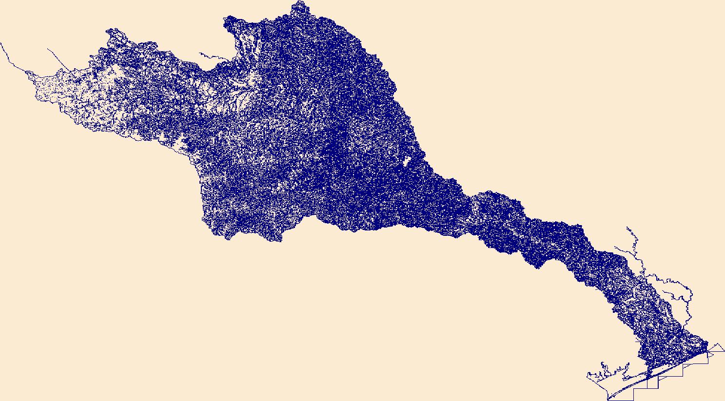
Tags: Austin County,
Bastrop County,
Blanco County,
Brazoria County,
Brown County, All tags...
Burnet County,
Caldwell County,
Callahan County,
Coke County,
Coleman County,
Colorado County,
Comanche County,
Concho County,
Crockett County,
Downloadable Data,
Eastland County,
Edwards County,
Fayette County,
FileGDB,
FileGDB 10.1,
Fort Bend County,
Gillespie County,
Glasscock County,
HU-4 Subregion,
HU-4 Subregion,
HU4_1209,
Hays County,
Howard County,
Hydrography,
Irion County,
Kendall County,
Kerr County,
Kimble County,
Lampasas County,
Lee County,
Llano County,
Mason County,
Matagorda County,
McCulloch County,
Menard County,
Midland County,
Mills County,
NHDPlus HR Rasters,
NHDPlus High Resolution (NHDPlus HR),
National Hydrography Dataset (NHD),
National Hydrography Dataset Plus High Resolution (NHDPlus HR),
National Hydrography Dataset Plus High Resolution (NHDPlus HR) Current,
Nolan County,
Reagan County,
Real County,
Runnels County,
San Saba County,
Schleicher County,
Sterling County,
Sutton County,
TX,
Taylor County,
Texas,
Tom Green County,
Travis County,
US,
United States,
Upton County,
Washington County,
Wharton County,
Williamson County,
base maps,
cartography,
catchments,
channels,
digital elevation models,
drainage basins,
earth sciences,
elevation,
environment,
geographic information systems,
geoscientific,
geospatial analysis,
hydrographic datasets,
hydrographic features,
hydrology,
imagery,
inland waters,
lakes,
land surface characteristics,
reservoirs,
river reaches,
rivers,
streamflow,
streamflow data,
streams,
topography,
water bodies,
water quality,
water resources,
watersheds, Fewer tags
The High Resolution National Hydrography Dataset Plus (NHDPlus HR) is an integrated set of geospatial data layers, including the best available National Hydrography Dataset (NHD), the 10-meter 3D Elevation Program Digital Elevation Model (3DEP DEM), and the National Watershed Boundary Dataset (WBD). The NHDPlus HR combines the NHD, 3DEP DEMs, and WBD to create a stream network with linear referencing, feature naming, "value added attributes" (VAAs), elevation-derived catchments, and other features for hydrologic data analysis. The stream network with linear referencing is a system of data relationships applied to hydrographic systems so that one stream reach "flows" into another and "events" can be tied to and traced...
Tags: Blue EarthCounty,
BuffaloCounty,
ClarkCounty,
DakotaCounty,
DodgeCounty, All tags...
Downloadable Data,
Eau ClaireCounty,
FileGDB,
FileGDB 10.1,
FillmoreCounty,
FreebornCounty,
GoodhueCounty,
HU-4 Subregion,
HU-4 Subregion,
HoustonCounty,
Hydrography,
JacksonCounty,
La CrosseCounty,
Le SueurCounty,
MarathonCounty,
MonroeCounty,
MowerCounty,
NHDPlus HR Rasters,
NHDPlus High Resolution (NHDPlus HR),
National Hydrography Dataset (NHD),
National Hydrography Dataset Plus High Resolution (NHDPlus HR),
National Hydrography Dataset Plus High Resolution (NHDPlus HR) Current,
OlmstedCounty,
PepinCounty,
PierceCounty,
RiceCounty,
ScottCounty,
St. CroixCounty,
SteeleCounty,
TaylorCounty,
TrempealeauCounty,
US,
United States,
WI,
WabashaCounty,
WasecaCounty,
WashingtonCounty,
WinneshiekCounty,
WinonaCounty,
Wisconsin,
WoodCounty,
base maps,
cartography,
catchments,
channels,
digital elevation models,
drainage basins,
earth sciences,
elevation,
environment,
geographic information systems,
geoscientific,
geospatial analysis,
hydrographic datasets,
hydrographic features,
hydrology,
imagery,
inland waters,
lakes,
land surface characteristics,
reservoirs,
river reaches,
rivers,
streamflow,
streamflow data,
streams,
topography,
water bodies,
water quality,
water resources,
watersheds, Fewer tags
The High Resolution National Hydrography Dataset Plus (NHDPlus HR) is an integrated set of geospatial data layers, including the best available National Hydrography Dataset (NHD), the 10-meter 3D Elevation Program Digital Elevation Model (3DEP DEM), and the National Watershed Boundary Dataset (WBD). The NHDPlus HR combines the NHD, 3DEP DEMs, and WBD to create a stream network with linear referencing, feature naming, "value added attributes" (VAAs), elevation-derived catchments, and other features for hydrologic data analysis. The stream network with linear referencing is a system of data relationships applied to hydrographic systems so that one stream reach "flows" into another and "events" can be tied to and traced...
Tags: AdairCounty,
AdamsCounty,
AndrewCounty,
AtchisonCounty,
AtchisonCounty, All tags...
AudubonCounty,
BrownCounty,
BuchananCounty,
CarrollCounty,
CassCounty,
CassCounty,
ClayCounty,
ClintonCounty,
CrawfordCounty,
DeKalbCounty,
DoniphanCounty,
Downloadable Data,
FileGDB,
FileGDB 10.1,
FremontCounty,
GageCounty,
GentryCounty,
GuthrieCounty,
HU-4 Subregion,
HU-4 Subregion,
HarrisonCounty,
HoltCounty,
Hydrography,
JohnsonCounty,
LancasterCounty,
LeavenworthCounty,
MO,
MarshallCounty,
MillsCounty,
Missouri,
MontgomeryCounty,
NHDPlus HR Rasters,
NHDPlus High Resolution (NHDPlus HR),
National Hydrography Dataset (NHD),
National Hydrography Dataset Plus High Resolution (NHDPlus HR),
National Hydrography Dataset Plus High Resolution (NHDPlus HR) Current,
NemahaCounty,
NemahaCounty,
NodawayCounty,
OtoeCounty,
PageCounty,
PawneeCounty,
PlatteCounty,
PottawattamieCounty,
RichardsonCounty,
RinggoldCounty,
SarpyCounty,
ShelbyCounty,
TaylorCounty,
US,
UnionCounty,
United States,
WorthCounty,
WyandotteCounty,
base maps,
cartography,
catchments,
channels,
digital elevation models,
drainage basins,
earth sciences,
elevation,
environment,
geographic information systems,
geoscientific,
geospatial analysis,
hydrographic datasets,
hydrographic features,
hydrology,
imagery,
inland waters,
lakes,
land surface characteristics,
reservoirs,
river reaches,
rivers,
streamflow,
streamflow data,
streams,
topography,
water bodies,
water quality,
water resources,
watersheds, Fewer tags
The High Resolution National Hydrography Dataset Plus (NHDPlus HR) is an integrated set of geospatial data layers, including the best available National Hydrography Dataset (NHD), the 10-meter 3D Elevation Program Digital Elevation Model (3DEP DEM), and the National Watershed Boundary Dataset (WBD). The NHDPlus HR combines the NHD, 3DEP DEMs, and WBD to create a stream network with linear referencing, feature naming, "value added attributes" (VAAs), elevation-derived catchments, and other features for hydrologic data analysis. The stream network with linear referencing is a system of data relationships applied to hydrographic systems so that one stream reach "flows" into another and "events" can be tied to and traced...
Tags: AuroraCounty,
BarnesCounty,
BeadleCounty,
Bon HommeCounty,
BrownCounty, All tags...
ClarkCounty,
DavisonCounty,
DayCounty,
DickeyCounty,
DouglasCounty,
Downloadable Data,
EddyCounty,
EdmundsCounty,
FaulkCounty,
FileGDB,
FileGDB 10.1,
FosterCounty,
HU-4 Subregion,
HU-4 Subregion,
HandCounty,
HansonCounty,
HutchinsonCounty,
HydeCounty,
Hydrography,
JerauldCounty,
KidderCounty,
KingsburyCounty,
LaMoureCounty,
LoganCounty,
MarshallCounty,
McCookCounty,
McIntoshCounty,
McPhersonCounty,
MinerCounty,
NHDPlus HR Rasters,
NHDPlus High Resolution (NHDPlus HR),
National Hydrography Dataset (NHD),
National Hydrography Dataset Plus High Resolution (NHDPlus HR),
National Hydrography Dataset Plus High Resolution (NHDPlus HR) Current,
PotterCounty,
RansomCounty,
RobertsCounty,
SD,
SanbornCounty,
SargentCounty,
SheridanCounty,
South Dakota,
SpinkCounty,
StutsmanCounty,
TurnerCounty,
US,
United States,
WalworthCounty,
WellsCounty,
YanktonCounty,
base maps,
cartography,
catchments,
channels,
digital elevation models,
drainage basins,
earth sciences,
elevation,
environment,
geographic information systems,
geoscientific,
geospatial analysis,
hydrographic datasets,
hydrographic features,
hydrology,
imagery,
inland waters,
lakes,
land surface characteristics,
reservoirs,
river reaches,
rivers,
streamflow,
streamflow data,
streams,
topography,
water bodies,
water quality,
water resources,
watersheds, Fewer tags
The High Resolution National Hydrography Dataset Plus (NHDPlus HR) is an integrated set of geospatial data layers, including the best available National Hydrography Dataset (NHD), the 10-meter 3D Elevation Program Digital Elevation Model (3DEP DEM), and the National Watershed Boundary Dataset (WBD). The NHDPlus HR combines the NHD, 3DEP DEMs, and WBD to create a stream network with linear referencing, feature naming, "value added attributes" (VAAs), elevation-derived catchments, and other features for hydrologic data analysis. The stream network with linear referencing is a system of data relationships applied to hydrographic systems so that one stream reach "flows" into another and "events" can be tied to and traced...
Tags: Big StoneCounty,
Blue EarthCounty,
BrookingsCounty,
BrownCounty,
CarverCounty, All tags...
ChippewaCounty,
CodingtonCounty,
CottonwoodCounty,
DakotaCounty,
DayCounty,
DeuelCounty,
DouglasCounty,
Downloadable Data,
EmmetCounty,
FaribaultCounty,
FileGDB,
FileGDB 10.1,
FreebornCounty,
GrantCounty,
GrantCounty,
HU-4 Subregion,
HU-4 Subregion,
HennepinCounty,
Hydrography,
JacksonCounty,
KandiyohiCounty,
KossuthCounty,
Lac qui ParleCounty,
Le SueurCounty,
LincolnCounty,
LyonCounty,
MN,
MarshallCounty,
MartinCounty,
McLeodCounty,
Minnesota,
MurrayCounty,
NHDPlus HR Rasters,
NHDPlus High Resolution (NHDPlus HR),
National Hydrography Dataset (NHD),
National Hydrography Dataset Plus High Resolution (NHDPlus HR),
National Hydrography Dataset Plus High Resolution (NHDPlus HR) Current,
NicolletCounty,
Otter TailCounty,
PipestoneCounty,
PopeCounty,
RamseyCounty,
RedwoodCounty,
RenvilleCounty,
RiceCounty,
RichlandCounty,
RobertsCounty,
ScottCounty,
SibleyCounty,
StearnsCounty,
SteeleCounty,
StevensCounty,
SwiftCounty,
TraverseCounty,
US,
United States,
WasecaCounty,
WatonwanCounty,
WinnebagoCounty,
Yellow MedicineCounty,
base maps,
cartography,
catchments,
channels,
digital elevation models,
drainage basins,
earth sciences,
elevation,
environment,
geographic information systems,
geoscientific,
geospatial analysis,
hydrographic datasets,
hydrographic features,
hydrology,
imagery,
inland waters,
lakes,
land surface characteristics,
reservoirs,
river reaches,
rivers,
streamflow,
streamflow data,
streams,
topography,
water bodies,
water quality,
water resources,
watersheds, Fewer tags
The High Resolution National Hydrography Dataset Plus (NHDPlus HR) is an integrated set of geospatial data layers, including the best available National Hydrography Dataset (NHD), the 10-meter 3D Elevation Program Digital Elevation Model (3DEP DEM), and the National Watershed Boundary Dataset (WBD). The NHDPlus HR combines the NHD, 3DEP DEMs, and WBD to create a stream network with linear referencing, feature naming, "value added attributes" (VAAs), elevation-derived catchments, and other features for hydrologic data analysis. The stream network with linear referencing is a system of data relationships applied to hydrographic systems so that one stream reach "flows" into another and "events" can be tied to and traced...
Tags: BeaverheadCounty,
BroadwaterCounty,
ClarkCounty,
Deer LodgeCounty,
Downloadable Data, All tags...
FileGDB,
FileGDB 10.1,
FremontCounty,
GallatinCounty,
GraniteCounty,
HU-4 Subregion,
HU-4 Subregion,
Hydrography,
ID,
Idaho,
JeffersonCounty,
LemhiCounty,
Lewis and ClarkCounty,
MadisonCounty,
NHDPlus HR Rasters,
NHDPlus High Resolution (NHDPlus HR),
National Hydrography Dataset (NHD),
National Hydrography Dataset Plus High Resolution (NHDPlus HR),
National Hydrography Dataset Plus High Resolution (NHDPlus HR) Current,
ParkCounty,
ParkCounty,
PowellCounty,
RavalliCounty,
Silver BowCounty,
TetonCounty,
US,
United States,
base maps,
cartography,
catchments,
channels,
digital elevation models,
drainage basins,
earth sciences,
elevation,
environment,
geographic information systems,
geoscientific,
geospatial analysis,
hydrographic datasets,
hydrographic features,
hydrology,
imagery,
inland waters,
lakes,
land surface characteristics,
reservoirs,
river reaches,
rivers,
streamflow,
streamflow data,
streams,
topography,
water bodies,
water quality,
water resources,
watersheds, Fewer tags
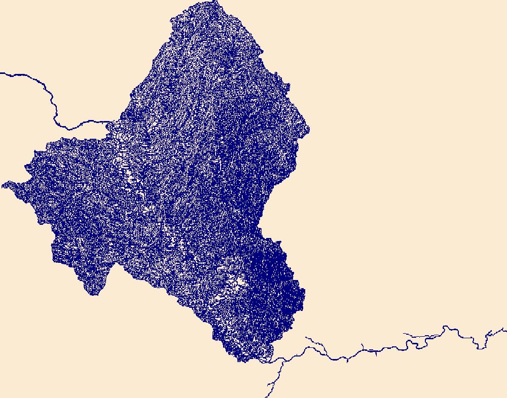
The High Resolution National Hydrography Dataset Plus (NHDPlus HR) is an integrated set of geospatial data layers, including the best available National Hydrography Dataset (NHD), the 10-meter 3D Elevation Program Digital Elevation Model (3DEP DEM), and the National Watershed Boundary Dataset (WBD). The NHDPlus HR combines the NHD, 3DEP DEMs, and WBD to create a stream network with linear referencing, feature naming, "value added attributes" (VAAs), elevation-derived catchments, and other features for hydrologic data analysis. The stream network with linear referencing is a system of data relationships applied to hydrographic systems so that one stream reach "flows" into another and "events" can be tied to and traced...
Tags: Benson County,
Bottineau County,
Burke County,
Divide County,
Downloadable Data, All tags...
FileGDB,
FileGDB 10.1,
HU-4 Subregion,
HU-4 Subregion,
HU4_0901,
Hydrography,
McHenry County,
McLean County,
Mountrail County,
ND,
NHDPlus HR Rasters,
NHDPlus High Resolution (NHDPlus HR),
National Hydrography Dataset (NHD),
National Hydrography Dataset Plus High Resolution (NHDPlus HR),
National Hydrography Dataset Plus High Resolution (NHDPlus HR) Current,
North Dakota,
Pierce County,
Renville County,
Rolette County,
Sheridan County,
US,
United States,
Ward County,
base maps,
cartography,
catchments,
channels,
digital elevation models,
drainage basins,
earth sciences,
elevation,
environment,
geographic information systems,
geoscientific,
geospatial analysis,
hydrographic datasets,
hydrographic features,
hydrology,
imagery,
inland waters,
lakes,
land surface characteristics,
reservoirs,
river reaches,
rivers,
streamflow,
streamflow data,
streams,
topography,
water bodies,
water quality,
water resources,
watersheds, Fewer tags
The High Resolution National Hydrography Dataset Plus (NHDPlus HR) is an integrated set of geospatial data layers, including the best available National Hydrography Dataset (NHD), the 10-meter 3D Elevation Program Digital Elevation Model (3DEP DEM), and the National Watershed Boundary Dataset (WBD). The NHDPlus HR combines the NHD, 3DEP DEMs, and WBD to create a stream network with linear referencing, feature naming, "value added attributes" (VAAs), elevation-derived catchments, and other features for hydrologic data analysis. The stream network with linear referencing is a system of data relationships applied to hydrographic systems so that one stream reach "flows" into another and "events" can be tied to and traced...
Tags: AntelopeCounty,
ArthurCounty,
BlaineCounty,
BooneCounty,
BrownCounty, All tags...
BuffaloCounty,
CherryCounty,
CusterCounty,
DawsonCounty,
Downloadable Data,
FileGDB,
FileGDB 10.1,
GardenCounty,
GarfieldCounty,
GrantCounty,
GreeleyCounty,
HU-4 Subregion,
HU-4 Subregion,
HallCounty,
HoltCounty,
HookerCounty,
HowardCounty,
Hydrography,
LincolnCounty,
LoganCounty,
LoupCounty,
McPhersonCounty,
MerrickCounty,
NE,
NHDPlus HR Rasters,
NHDPlus High Resolution (NHDPlus HR),
NanceCounty,
National Hydrography Dataset (NHD),
National Hydrography Dataset Plus High Resolution (NHDPlus HR),
National Hydrography Dataset Plus High Resolution (NHDPlus HR) Current,
Nebraska,
PlatteCounty,
RockCounty,
SheridanCounty,
ShermanCounty,
ThomasCounty,
US,
United States,
ValleyCounty,
WheelerCounty,
base maps,
cartography,
catchments,
channels,
digital elevation models,
drainage basins,
earth sciences,
elevation,
environment,
geographic information systems,
geoscientific,
geospatial analysis,
hydrographic datasets,
hydrographic features,
hydrology,
imagery,
inland waters,
lakes,
land surface characteristics,
reservoirs,
river reaches,
rivers,
streamflow,
streamflow data,
streams,
topography,
water bodies,
water quality,
water resources,
watersheds, Fewer tags

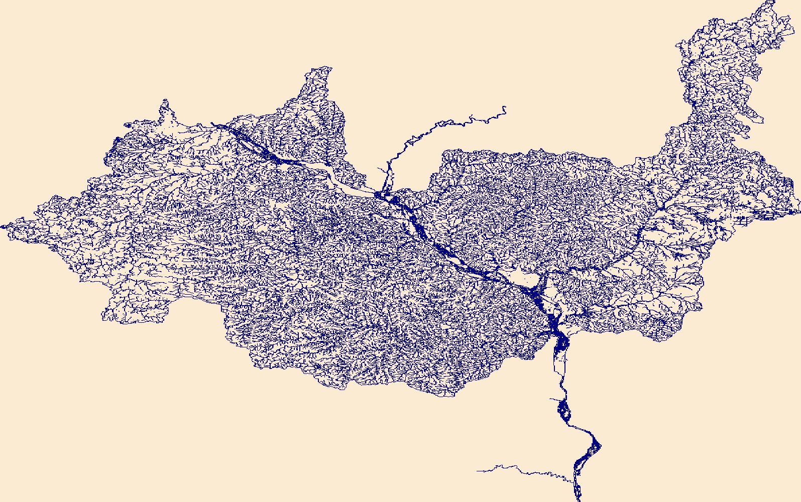
The High Resolution National Hydrography Dataset Plus (NHDPlus HR) is an integrated set of geospatial data layers, including the best available National Hydrography Dataset (NHD), the 10-meter 3D Elevation Program Digital Elevation Model (3DEP DEM), and the National Watershed Boundary Dataset (WBD). The NHDPlus HR combines the NHD, 3DEP DEMs, and WBD to create a stream network with linear referencing, feature naming, "value added attributes" (VAAs), elevation-derived catchments, and other features for hydrologic data analysis. The stream network with linear referencing is a system of data relationships applied to hydrographic systems so that one stream reach "flows" into another and "events" can be tied to and traced...
Tags: Alexander County,
Ballard County,
Bollinger County,
Bond County,
Cape Girardeau County, All tags...
Champaign County,
Christian County,
Clinton County,
Coles County,
Crawford County,
Dent County,
Douglas County,
Downloadable Data,
Effingham County,
Fayette County,
FileGDB,
FileGDB 10.1,
Franklin County,
Franklin County,
Gasconade County,
HU-4 Subregion,
HU-4 Subregion,
HU4_0714,
Hamilton County,
Hydrography,
IL,
Illinois,
Iron County,
Jackson County,
Jefferson County,
Jefferson County,
Johnson County,
KY,
Kentucky,
MO,
Macon County,
Macoupin County,
Madison County,
Madison County,
Maries County,
Marion County,
Mississippi County,
Missouri,
Monroe County,
Montgomery County,
Moultrie County,
NHDPlus HR Rasters,
NHDPlus High Resolution (NHDPlus HR),
National Hydrography Dataset (NHD),
National Hydrography Dataset Plus High Resolution (NHDPlus HR),
National Hydrography Dataset Plus High Resolution (NHDPlus HR) Current,
Osage County,
Perry County,
Perry County,
Phelps County,
Piatt County,
Pulaski County,
Randolph County,
Reynolds County,
Scott County,
Shelby County,
St. Clair County,
St. Francois County,
St. Louis County,
St. Louis County,
Ste. Genevieve County,
Texas County,
US,
Union County,
United States,
Washington County,
Washington County,
Wayne County,
Williamson County,
base maps,
cartography,
catchments,
channels,
digital elevation models,
drainage basins,
earth sciences,
elevation,
environment,
geographic information systems,
geoscientific,
geospatial analysis,
hydrographic datasets,
hydrographic features,
hydrology,
imagery,
inland waters,
lakes,
land surface characteristics,
reservoirs,
river reaches,
rivers,
streamflow,
streamflow data,
streams,
topography,
water bodies,
water quality,
water resources,
watersheds, Fewer tags
The High Resolution National Hydrography Dataset Plus (NHDPlus HR) is an integrated set of geospatial data layers, including the best available National Hydrography Dataset (NHD), the 10-meter 3D Elevation Program Digital Elevation Model (3DEP DEM), and the National Watershed Boundary Dataset (WBD). The NHDPlus HR combines the NHD, 3DEP DEMs, and WBD to create a stream network with linear referencing, feature naming, "value added attributes" (VAAs), elevation-derived catchments, and other features for hydrologic data analysis. The stream network with linear referencing is a system of data relationships applied to hydrographic systems so that one stream reach "flows" into another and "events" can be tied to and traced...
Tags: CA,
California,
ColusaCounty,
CurryCounty,
Del NorteCounty, All tags...
DouglasCounty,
Downloadable Data,
FileGDB,
FileGDB 10.1,
GlennCounty,
HU-4 Subregion,
HU-4 Subregion,
HumboldtCounty,
Hydrography,
JacksonCounty,
JosephineCounty,
KlamathCounty,
LakeCounty,
LakeCounty,
MarinCounty,
MendocinoCounty,
ModocCounty,
NHDPlus HR Rasters,
NHDPlus High Resolution (NHDPlus HR),
NapaCounty,
National Hydrography Dataset (NHD),
National Hydrography Dataset Plus High Resolution (NHDPlus HR),
National Hydrography Dataset Plus High Resolution (NHDPlus HR) Current,
ShastaCounty,
SiskiyouCounty,
SonomaCounty,
TehamaCounty,
TrinityCounty,
US,
United States,
base maps,
cartography,
catchments,
channels,
digital elevation models,
drainage basins,
earth sciences,
elevation,
environment,
geographic information systems,
geoscientific,
geospatial analysis,
hydrographic datasets,
hydrographic features,
hydrology,
imagery,
inland waters,
lakes,
land surface characteristics,
reservoirs,
river reaches,
rivers,
streamflow,
streamflow data,
streams,
topography,
water bodies,
water quality,
water resources,
watersheds, Fewer tags
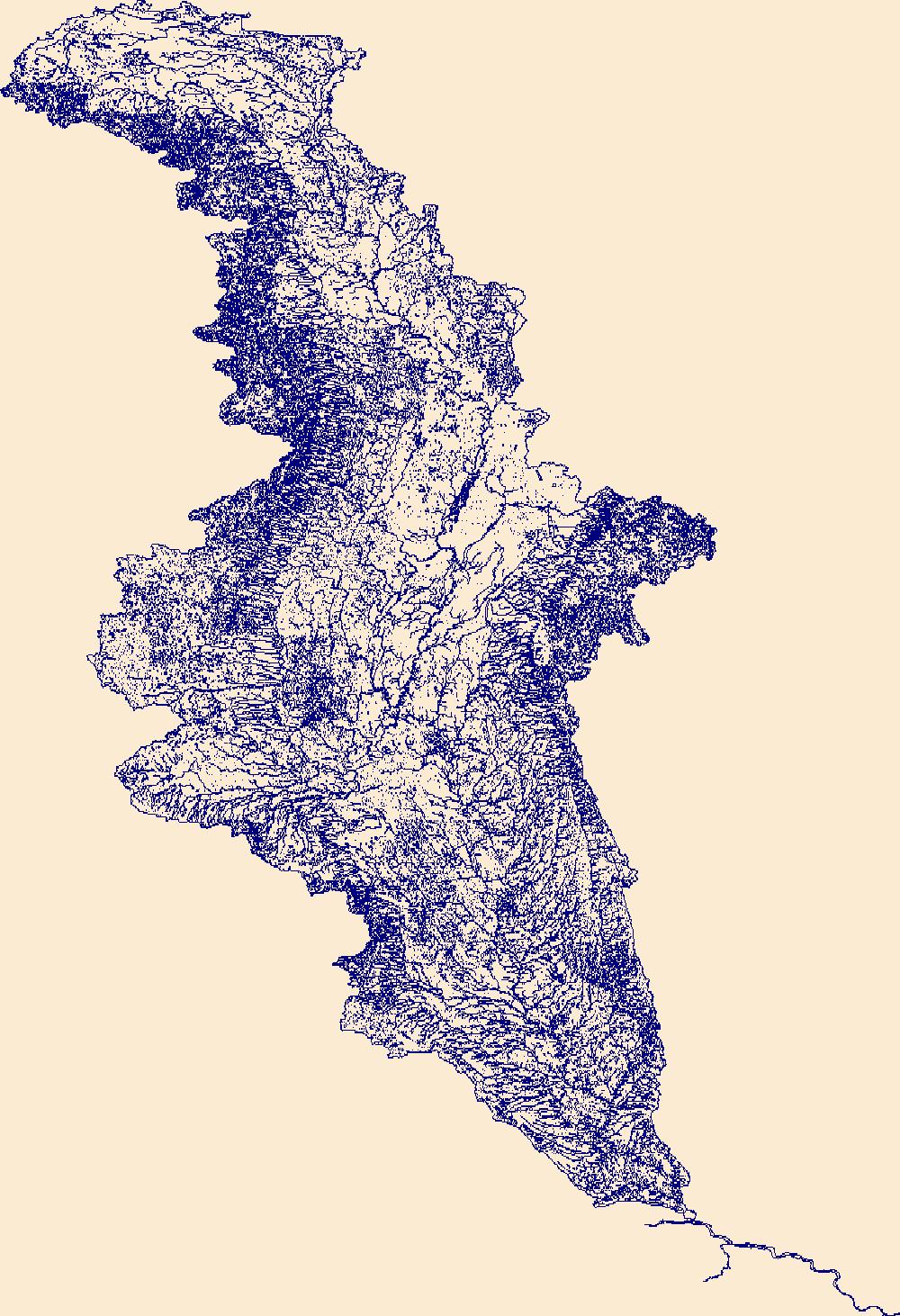
The High Resolution National Hydrography Dataset Plus (NHDPlus HR) is an integrated set of geospatial data layers, including the best available National Hydrography Dataset (NHD), the 10-meter 3D Elevation Program Digital Elevation Model (3DEP DEM), and the National Watershed Boundary Dataset (WBD). The NHDPlus HR combines the NHD, 3DEP DEMs, and WBD to create a stream network with linear referencing, feature naming, "value added attributes" (VAAs), elevation-derived catchments, and other features for hydrologic data analysis. The stream network with linear referencing is a system of data relationships applied to hydrographic systems so that one stream reach "flows" into another and "events" can be tied to and traced...
Tags: Allegany County,
Allegheny County,
Armstrong County,
Bedford County,
Blair County, All tags...
Butler County,
Cambria County,
Cameron County,
Cattaraugus County,
Chautauqua County,
Clarion County,
Clearfield County,
Crawford County,
Downloadable Data,
Elk County,
Erie County,
FileGDB,
FileGDB 10.1,
Forest County,
HU-4 Subregion,
HU-4 Subregion,
HU4_0501,
Hydrography,
Indiana County,
Jefferson County,
McKean County,
Mercer County,
NHDPlus HR Rasters,
NHDPlus High Resolution (NHDPlus HR),
NY,
National Hydrography Dataset (NHD),
National Hydrography Dataset Plus High Resolution (NHDPlus HR),
National Hydrography Dataset Plus High Resolution (NHDPlus HR) Current,
New York,
PA,
Pennsylvania,
Potter County,
Somerset County,
US,
United States,
Venango County,
Warren County,
Westmoreland County,
base maps,
cartography,
catchments,
channels,
digital elevation models,
drainage basins,
earth sciences,
elevation,
environment,
geographic information systems,
geoscientific,
geospatial analysis,
hydrographic datasets,
hydrographic features,
hydrology,
imagery,
inland waters,
lakes,
land surface characteristics,
reservoirs,
river reaches,
rivers,
streamflow,
streamflow data,
streams,
topography,
water bodies,
water quality,
water resources,
watersheds, Fewer tags
The High Resolution National Hydrography Dataset Plus (NHDPlus HR) is an integrated set of geospatial data layers, including the best available National Hydrography Dataset (NHD), the 10-meter 3D Elevation Program Digital Elevation Model (3DEP DEM), and the National Watershed Boundary Dataset (WBD). The NHDPlus HR combines the NHD, 3DEP DEMs, and WBD to create a stream network with linear referencing, feature naming, "value added attributes" (VAAs), elevation-derived catchments, and other features for hydrologic data analysis. The stream network with linear referencing is a system of data relationships applied to hydrographic systems so that one stream reach "flows" into another and "events" can be tied to and traced...
Tags: Adair County,
Allen County,
Barren County,
Breckinridge County,
Butler County, All tags...
Casey County,
Christian County,
Clay County,
Daviess County,
Downloadable Data,
Edmonson County,
FileGDB,
FileGDB 10.1,
Grayson County,
Green County,
HU-4 Subregion,
HU-4 Subregion,
HU4_0511,
Hancock County,
Hardin County,
Hart County,
Henderson County,
Hopkins County,
Hydrography,
Jackson County,
KY,
Kentucky,
Larue County,
Lincoln County,
Logan County,
Macon County,
Marion County,
McLean County,
Metcalfe County,
Monroe County,
Muhlenberg County,
NHDPlus HR Rasters,
NHDPlus High Resolution (NHDPlus HR),
National Hydrography Dataset (NHD),
National Hydrography Dataset Plus High Resolution (NHDPlus HR),
National Hydrography Dataset Plus High Resolution (NHDPlus HR) Current,
Ohio County,
Pulaski County,
Robertson County,
Russell County,
Simpson County,
Sumner County,
TN,
Taylor County,
Tennessee,
Todd County,
US,
United States,
Warren County,
Webster County,
base maps,
cartography,
catchments,
channels,
digital elevation models,
drainage basins,
earth sciences,
elevation,
environment,
geographic information systems,
geoscientific,
geospatial analysis,
hydrographic datasets,
hydrographic features,
hydrology,
imagery,
inland waters,
lakes,
land surface characteristics,
reservoirs,
river reaches,
rivers,
streamflow,
streamflow data,
streams,
topography,
water bodies,
water quality,
water resources,
watersheds, Fewer tags
|
|

