Filters: Tags: fish and wildlife service (X)
40 results (11ms)|
Filters
Date Range
Extensions Types
Contacts
Categories Tag Types
|

This map layer consists of federally owned or administered lands of the United States, Puerto Rico, and the U.S. Virgin Islands. For the most part, only areas of 320 acres or more are included; some smaller areas deemed to be important or significant are also included. There may be private inholdings within the boundaries of Federal lands in this map layer. Some established Federal lands which are larger than 320 acres are not included in this map layer, because their boundaries were not available from the owning or administering agency.
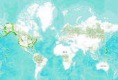
U.S. Fish and Wildlife Regional Boundaries

This layer was created from the U.S. Fish and Wildlife Service Landscape Conservation Cooperatives data for the purpose of serving as a mask to show only land areas covered by the South Atlantic LCC geographic area. Landscape conservation cooperatives (LCCs) are conservation-science partnerships between the U.S. Fish and Wildlife Service, U.S. Geological Survey (USGS), and other federal agencies, states, tribes, NGOs, universities and stakeholders within a geographically defined area. They inform resource management decisions to address national-scale stressors-including habitat fragmentation, genetic isolation, spread of invasive species, and water scarcity-all of which are accelerated by climate change.
Landscape conservation cooperatives (LCCs) are conservation-science partnerships between the U.S. Fish and Wildlife Service, U.S. Geological Survey (USGS), and other federal agencies, states, tribes, NGOs, universities and stakeholders within a geographically defined area. They inform resource management decisions to address national-scale stressors-including habitat fragmentation, genetic isolation, spread of invasive species, and water scarcity-all of which are accelerated by climate change.

This map layer shows Indian lands of the United States. For the most part, only areas of 320 acres or more are included; some smaller areas deemed to be important or significant are also included. Federally-administered lands within a reservation are included for continuity; these may or may not be considered part of the reservation and are simply described with their feature type and the administrating Federal agency. Some established Indian lands which are larger than 320 acres are not included in this map layer because their boundaries were not available from the owning or administering agency.

Landscape conservation cooperatives (LCCs) are conservation-science partnerships between the U.S. Fish and Wildlife Service, U.S. Geological Survey (USGS), and other federal agencies, states, tribes, NGOs, universities and stakeholders within a geographically defined area. They inform resource management decisions to address national-scale stressors-including habitat fragmentation, genetic isolation, spread of invasive species, and water scarcity-all of which are accelerated by climate change.

Landscape conservation cooperatives (LCCs) are conservation-science partnerships between the U.S. Fish and Wildlife Service, U.S. Geological Survey (USGS), and other federal agencies, states, tribes, NGOs, universities and stakeholders within a geographically defined area. They inform resource management decisions to address national-scale stressors-including habitat fragmentation, genetic isolation, spread of invasive species, and water scarcity-all of which are accelerated by climate change.

Landscape conservation cooperatives (LCCs) are conservation-science partnerships between the U.S. Fish and Wildlife Service, U.S. Geological Survey (USGS), and other federal agencies, states, tribes, NGOs, universities and stakeholders within a geographically defined area. They inform resource management decisions to address national-scale stressors-including habitat fragmentation, genetic isolation, spread of invasive species, and water scarcity-all of which are accelerated by climate change.

This dataset represents the North Atlantic LCC's ecoregion boundary. Landscape conservation cooperatives (LCCs) are conservation-science partnerships between the U.S. Fish and Wildlife Service, U.S. Geological Survey (USGS), and other federal agencies, states, tribes, NGOs, universities and stakeholders within a geographically defined area. They inform resource management decisions to address national-scale stressors-including habitat fragmentation, genetic isolation, spread of invasive species, and water scarcity-all of which are accelerated by climate change.

Landscape conservation cooperatives (LCCs) are conservation-science partnerships between the U.S. Fish and Wildlife Service, U.S. Geological Survey (USGS), and other federal agencies, states, tribes, NGOs, universities and stakeholders within a geographically defined area. They inform resource management decisions to address national-scale stressors-including habitat fragmentation, genetic isolation, spread of invasive species, and water scarcity-all of which are accelerated by climate change.
This data layer consists of National Wilderness Preservation System areas in the United States, Puerto Rico, and the U.S. Virgin Islands. The map layer was created by combining the best available data from the federal agency responsible for administration of a given wilderness area. Where larger scale data could not be obtained the National Atlas layer "National Wilderness Preservation System" was used as the data source. In its present form source data varies from a scale of 1:10000 to 1:2,000,000 (see lineage for details on source scale). Additional features have been added by the Environmental Science Division, Argonne National Laboratory based on their work with federal agencies; mainly BLM.

Landscape conservation cooperatives (LCCs) are conservation-science partnerships between the U.S. Fish and Wildlife Service, U.S. Geological Survey (USGS), and other federal agencies, states, tribes, NGOs, universities and stakeholders within a geographically defined area. They inform resource management decisions to address national-scale stressors-including habitat fragmentation, genetic isolation, spread of invasive species, and water scarcity-all of which are accelerated by climate change.
Landscape conservation cooperatives (LCCs) are conservation-science partnerships between the U.S. Fish and Wildlife Service, U.S. Geological Survey (USGS), and other federal agencies, states, tribes, NGOs, universities and stakeholders within a geographically defined area. They inform resource management decisions to address national-scale stressors-including habitat fragmentation, genetic isolation, spread of invasive species, and water scarcity-all of which are accelerated by climate change. LCCs provide scientific and technical support for conservation at "landscape" scales-the entire range of an identified priority species or groups of species. They support biological planning, conservation design,...
Categories: Data;
Types: Downloadable,
Map Service,
OGC WFS Layer,
OGC WMS Layer,
Shapefile;
Tags: Landscape Conservation Cooperatives,
conservation,
fish and wildlife service,
partnerships
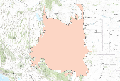
This metadata is for the vegetation land-cover and land-use spatial database created at/for Ouray National Wildlife Refuge, Utah.
This metadata is for the vegetation land-cover and land-use spatial database created at/for Lacreek National Wildlife Refuge, Utah
Cover title. "Submitted as a product of the Information and Education Committee of the Recovery Implementation Program for endangered fish of the upper Colorado River Basin.". Shipping list no.: 93-0631-P. "September 1993"--T.p. verso. Includes bibliographical references (p. [61]-63). Published by Fish and Wildlife Service, in 1993.
Categories: Publication;
Types: Book Citation,
Citation;
Tags: Colorado River Watershed (Colo.-Mexico),
Endangered species,
Fish and Wildlife Service,
History,
Rare fishes

Landscape conservation cooperatives (LCCs) are conservation-science partnerships between the U.S. Fish and Wildlife Service, U.S. Geological Survey (USGS), and other federal agencies, states, tribes, NGOs, universities and stakeholders within a geographically defined area. They inform resource management decisions to address national-scale stressors-including habitat fragmentation, genetic isolation, spread of invasive species, and water scarcity-all of which are accelerated by climate change.

Landscape conservation cooperatives (LCCs) are conservation-science partnerships between the U.S. Fish and Wildlife Service, U.S. Geological Survey (USGS), and other federal agencies, states, tribes, NGOs, universities and stakeholders within a geographically defined area. They inform resource management decisions to address national-scale stressors-including habitat fragmentation, genetic isolation, spread of invasive species, and water scarcity-all of which are accelerated by climate change.
This data layer consists of National Wilderness Preservation System areas in the United States, Puerto Rico, and the U.S. Virgin Islands. The map layer was created by combining the best available data from the federal agency responsible for administration of a given wilderness area. Where larger scale data could not be obtained the National Atlas layer "National Wilderness Preservation System" was used as the data source. In its present form source data varies from a scale of 1:10000 to 1:2,000,000 (see lineage for details on source scale). Additional features have been added by the Environmental Science Division, Argonne National Laboratory based on their work with federal agencies; mainly BLM.
This data layer consists of National Wilderness Preservation System areas in the United States, Puerto Rico, and the U.S. Virgin Islands. The map layer was created by combining the best available data from the federal agency responsible for administration of a given wilderness area. Where larger scale data could not be obtained the National Atlas layer "National Wilderness Preservation System" was used as the data source. In its present form source data varies from a scale of 1:10000 to 1:2,000,000 (see lineage for details on source scale).
|

|
