Filters: Tags: forest cover (X) > partyWithName: Conservation Biology Institute (X)
15 results (47ms)|
Filters
Date Range
Tag Schemes |

Abstract: This dataset portrays 28 forest type groups across the contiguous United States. These data were derived from MODIS composite images from the 2002 and 2003 growing seasons in combination with nearly 100 other geospatial data layers, including elevation, slope, aspect, ecoregions, and PRISM climate data. The dataset was developed as a collaborative effort between the USFS Forest Inventory and Analysis and Forest Health Monitoring programs and the USFS Remote Sensing Applications Center. Â Purpose: The purpose of this dataset is to portray broad distribution patterns of forest cover in the United States and provide input to national scale modeling projects. The data should not be displayed at scales smaller...
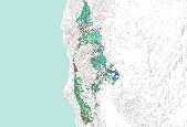
This dataset depicts forest cover on privately owned lands. Forest cover was determined using Landsat 7 ETM+ imagery from mainly summer 2000 and some from 1999. The remote imagery analysis was conducted by Hong Jiang and Jim Strittholt at Conservation Biology Institute. Cell resolution is 30 m. In 1999, the Conservation Biology Institute (CBI) concluded a conservation science assessment of the Klamath-Siskiyou ecoregion culminating in the report “A Science-based Conservation Assessment for the Klamath-Siskiyou Ecoregion.” Numerous ecological assessments were conducted and a conservation plan was proposed based on the results for special elements, ecosystem representation, and focal species. That study focused...

This dataset portrays 28 forest type groups across the contiguous United States. These data were derived from MODIS composite images from the 2002 and 2003 growing seasons in combination with nearly 100 other geospatial data layers, including elevation, slope, aspect, ecoregions, and PRISM climate data. The dataset was developed as a collaborative effort between the USFS Forest Inventory and Analysis and Forest Health Monitoring programs and the USFS Remote Sensing Applications Center.

This dataset portrays 61 forest group types across the southeastern United States. These data were derived from a product created by the USFS Forest Inventory and Analysis (FIA) program and the Remote Sensing Applications Center (RSAC). Â The original dataset (accessible from the US Forest Service Website) consists of 141 forest types across the contiguous United States. The original dataset was downloaded on 12/13/2013, clipped to the southeastern states, Â and used in a generalization procedure which involved the application of a majority filter (8 neighbors, half replacement threshold) followed by a sieving process which removed pixels in groups of four or less by reassigning them to their nearest neighbor value....

This dataset portrays 141 forest types across Alaska. These data were derived from MODIS composite images from the 2002 and 2003 growing seasons in combination with nearly 100 other geospatial data layers, including elevation, slope, aspect, and ecoregions. The dataset was developed as a collaborative effort between the USFS Forest Inventory and Analysis and Forest Health Monitoring programs and the USFS Remote Sensing Applications Center.

Abstract: This dataset portrays 141 forest types across the contiguous United States. These data were derived from MODIS composite images from the 2002 and 2003 growing seasons in combination with nearly 100 other geospatial data layers, including elevation, slope, aspect, ecoregions, and PRISM climate data. The dataset was developed as a collaborative effort between the USFS Forest Inventory and Analysis and Forest Health Monitoring programs and the USFS Remote Sensing Applications Center. Purpose: The purpose of this dataset is to portray broad distribution patterns of forest cover in the United States and provide input to national scale modeling projects. The data should not be displayed at scales smaller than...
This dataset portrays 28 forest type groups across the contiguous United States. These data were derived from MODIS composite images from the 2002 and 2003 growing seasons in combination with nearly 100 other geospatial data layers, including elevation, slope, aspect, ecoregions, and PRISM climate data. The dataset was developed as a collaborative effort between the USFS Forest Inventory and Analysis and Forest Health Monitoring programs and the USFS Remote Sensing Applications Center.

This dataset portrays 11 forest group types across the southeastern United States. These data were derived from a product created by the USFS Forest Inventory and Analysis (FIA) program and the Remote Sensing Applications Center (RSAC). Â The original dataset (accessible from the US Forest Service Website) consists of 28 forest type groups across the contiguous United States. The original dataset was downloaded on 12/13/2013, clipped to the southeastern states, Â and used in a generalization procedure which involved the application of a majority filter (8 neighbors, half replacement threshold) followed by a sieving process which removed pixels in groups of four or less by reassigning them to their nearest neighbor...

Forest resources in Washington and Oregon were surveyed in the early 1930s by employees of the Pacific Northwest Experimental Station (the original name of the current Pacific Northwest Research Station). This was the first of many periodic forest surveys conducted nationwide by the USDA Forest Service. Many publications and maps were produced from the Washington and Oregon 1930s survey data. Forest cover maps created from that data (at an original scale of 1:253, 440) have recently become available in digital formats, but little documentation was provided with the electronic files, and the older publications are not readily available to most users. The 27 forest cover types defined are the result of the combination...

This dataset portrays 28 forest type groups across the contiguous United States. These data were derived from MODIS composite images from the 2002 and 2003 growing seasons in combination with nearly 100 other geospatial data layers, including elevation, slope, aspect, ecoregions, and PRISM climate data. The dataset was developed as a collaborative effort between the USFS Forest Inventory and Analysis and Forest Health Monitoring programs and the USFS Remote Sensing Applications Center.

This dataset depicts portions of late seral forest (from the ForestCover grid) that are on privately owned lands for the Klamath-Siskiyou ecoregion. Only forest that was greater than 200 years old was included. Cell resolution is 30 m. Forest cover was determined using Landsat 7 ETM+ imagery from mainly summer 2000 and some from 1999. The remote imagery analysis was conducted by Hong Jiang and Jim Strittholt at Conservation Biology Institute. Cell resolution is 30 m. In 1999, the Conservation Biology Institute (CBI) concluded a conservation science assessment of the Klamath-Siskiyou ecoregion culminating in the report “A Science-based Conservation Assessment for the Klamath-Siskiyou Ecoregion.” Numerous ecological...

This dataset portrays 28 forest type groups across the contiguous United States. These data were derived from MODIS composite images from the 2002 and 2003 growing seasons in combination with nearly 100 other geospatial data layers, including elevation, slope, aspect, ecoregions, and PRISM climate data. The dataset was developed as a collaborative effort between the USFS Forest Inventory and Analysis and Forest Health Monitoring programs and the USFS Remote Sensing Applications Center.

This dataset portrays 28 forest type groups across the contiguous United States. These data were derived from MODIS composite images from the 2002 and 2003 growing seasons in combination with nearly 100 other geospatial data layers, including elevation, slope, aspect, ecoregions, and PRISM climate data. The dataset was developed as a collaborative effort between the USFS Forest Inventory and Analysis and Forest Health Monitoring programs and the USFS Remote Sensing Applications Center.

This dataset portrays 28 forest type groups across the contiguous United States. These data were derived from MODIS composite images from the 2002 and 2003 growing seasons in combination with nearly 100 other geospatial data layers, including elevation, slope, aspect, ecoregions, and PRISM climate data. The dataset was developed as a collaborative effort between the USFS Forest Inventory and Analysis and Forest Health Monitoring programs and the USFS Remote Sensing Applications Center.

This dataset portrays 28 forest type groups across Alaska. These data were derived from MODIS composite images from the 2002 and 2003 growing seasons in combination with nearly 100 other geospatial data layers, including elevation, slope, aspect, and ecoregions. The dataset was developed as a collaborative effort between the USFS Forest Inventory and Analysis and Forest Health Monitoring programs and the USFS Remote Sensing Applications Center.
|

|
