Filters: Tags: grazing (X)
161 results (78ms)|
Filters
Date Range
Extensions Types Contacts
Categories Tag Types
|
These data (all data tables for the data release) represent a suite of biotic and abiotic variables that characterized plant communities and the geologic, geomorphic, edaphic, climatic, and land use history context in which distinct plant communities occur. In 2009, the National Park Service's Inventory and Monitoring program for the Northern Colorado Plateau Network (NCPN) began measuring vegetation cover and site characteristics at monitoring plots stratified across different vegetation types within national parks on the Colorado Plateau. NCPN biologists remeasured vegetation cover at these plots in a rotating panel over the following decade. In 2019, U. S. Geological Survey geologists and soil scientists collected/compiled...
Resumen ejecutivo El objetivo del presente Plan Maestro de la Alianza Regional para la Conservación de Pastizales del Desierto Chihuahuense es brindar un marco de cooperación para la acción regional para los estados que integran el Desierto Chihuahuense. Como concepto rector de este documento se ha tomado el del desarrollo sustentable, es decir, se invita a explorar y abordar las vertientes sociales y económicas de toda actividad que tenga que ver con el manejo y uso de los pastizales como ecosistema natural y viceversa. Este documento está dividido en dos partes fundamentales. La primera ofrece una perspectiva continental y nacional sobre el Desierto Chihuahuense, su importancia ambiental, económica y social;...
Categories: Publication;
Types: Citation,
Map Service,
OGC WFS Layer,
OGC WMS Layer,
OGC WMS Service;
Tags: Chihuahuan Desert,
Mexico,
Spanish,
grassland,
grazing,
RESUMEN En México y EUA, los pastizales del Desierto Chihuahuense han experimentado un gran deterioro desde mediados de 1800's. Ello se ha debido principalmente deficientes prácticas ganaderas, al cambio climático, la supresión del fuego, a la fragmentación de hábitat y cambio de uso de suelo. En conjunto, se ha provocado un incremento en los escurrimientos y la erosión, una disminución de la diversidad biológica y pérdida en las concentraciones de aves, incremento en la invasión de especies no nativas y una disminución en la cantidad de forraje para animales domésticos y silvestres. La Estrategia para la Conservación de los Pastizales de Desierto Chihuahuense (ECOPAD) ofrece un esquema de cooperación para enfrentar...
Categories: Publication;
Types: Citation,
Map Service,
OGC WFS Layer,
OGC WMS Layer,
OGC WMS Service;
Tags: Chihuahuan Desert,
Mexico,
Spanish,
agriculture,
grassland,
El acervo de información geográfica se compone de nueve accesos en la sección Temas: Cartografía urbana, Catastro, Datos de relieve, Geodesia, Imágenes del territorio, Marco geoestadístico nacional, Nombres geográficos, Recursos naturales y Topografía. Lo mismo que en el ámbito estadístico, en el geográfico los recursos normativos y metodológicos son de gran importancia, ya que nos permiten conocer mejor los datos, además de propiciar condiciones que promueven la comparabilidad de la información con la adopción de principios homogéneos: en Aspectos normativos es posible consultar las clasificaciones y los catálogos, los metadatos geográficos, así como las normas técnicas empleadas en la generación de datos geográficos....
Types: Map Service,
OGC WFS Layer,
OGC WMS Layer,
OGC WMS Service;
Tags: Chihuahuan Desert,
GIS,
Mexico,
Sonoran Desert,
Spanish,
The Arizona Game and Fish Department (Department) recently revised its State Wildlife Action Plan that provides a framework and information to assist in setting conservation priorities for the state’s wildlife and habitats. Data gathered for Arizona’s State Wildlife Action Plan represents myriad sources and extensive public comment, and is used to support the Department’s efforts to develop proactive conservation goals and objectives. Much of that data (more than 300 data layers) is compiled into a single model of wildlife conservation potential, the Species and Habitat Conservation Guide. To ensure the State Wildlife Action Plan information is accessible and useful to everyone, the Arizona Game and Fish Department...
Types: Map Service,
OGC WFS Layer,
OGC WMS Layer,
OGC WMS Service;
Tags: Chihuahuan Desert,
English,
GIS,
Mojave Desert,
OHV,
Types: Map Service,
OGC WFS Layer,
OGC WMS Layer,
OGC WMS Service;
Tags: GIS,
New Mexico,
Texas,
burro,
grazing,
The REA estimates the condition of 14.2 million acres of land in southern New Mexico. It is based on states described in “ecological site descriptions” (ESDs) and expert knowledge. ESDs have been developed by the Natural Resource Conservation Service, and they are a consistent, science and expert-based resource increasingly used by land managers. It focuses on public rangelands - grasslands, shrublands, and savannas - managed by the Bureau of Land Management, and includes some other lands as well. The REA compares current condition to the expected or “reference” condition, and summarizes the vegetation, ecological processes and restorative management options of these states. Depending on these management options...
Categories: Data;
Types: ArcGIS REST Map Service,
ArcGIS Service Definition,
Downloadable,
Map Service,
OGC WFS Layer,
OGC WMS Layer,
OGC WMS Service;
Tags: Chihuahuan Desert,
English,
GIS,
US,
climate,
This presentation aired as part of the Great Basin LCC webinar series on September 13, 2017. Speakers include Courtney Conway, Idaho Cooperative Fish and Wildlife Research Unit, and Paul Makela, Bureau of Land Management.Description: Greater Sage-grouse have declined since the mid-1960s, and grazing is the most extensive land use within sage-grouse habitat. The speakers will present progress on a 10-year project designed to document the effects of cattle grazing on: 1) demographic traits of Greater Sage-grouse; 2) sage-grouse habitat characteristics, 3) insect abundance, which is important prey for sage-grouse chicks, and 4) abundance of all other bird species. The research team works at five study sites in Idaho...
Cheatgrass (Bromus tectorum L.) is an invasive annual grass that creates near-homogenous stands in areas throughout the Intermountain sagebrush steppe and challenges successful native plant restoration in these areas. A clipping experiment carried out at two cheatgrass-dominated sites in eastern Oregon (Lincoln Bench and Succor Creek) evaluated defoliation as a potential control method for cheatgrass and a seeding preparation method for native plant reseeding projects. Treatments involved clipping plants at two heights (tall=7.6 cm, and short=2.5 cm), two phenological stages (boot and purple), and two frequencies (once and twice), although purple-stage treatments were clipped only once. Treatments at each site were...
Categories: Publication;
Types: Citation,
Journal Citation;
Tags: Rangeland Ecology & Management,
cheatgrass,
clipping,
grazing,
livestock,
This data depicts range improvement projects (RIP) on BLM land in the Pinedale Field Office including type of project, located and date constructed or implemented. This data does not address condition of RIP. These projects are constructed with the objective of improving rangelands through the proper distribution of livestock.
Categories: Data;
Types: Downloadable;
Tags: BLM,
Big Piney,
Federal Government,
Grazing,
Over Grazing,
The data was produced from digitizing the legal land discriptions from the individual allotment folders at the Newcastle BLM field office. The data that was used to digitize from was the 1:100,000 ownership files and the 40 acre tic GCDB Gis data from the Wyoming State BLM office. This data is only as accurate as the ownership and GCDB data used. This data is intended for use by the BLM for management and navigational purposes.
Categories: Data;
Types: Downloadable;
Tags: BLM,
Federal Government,
Newcastle Field Office,
Wyoming,
allotments, range, range leases,
The fate of carbon (C) in organisms, food webs, and ecosystems is to a major extent regulated by mass-balance principles and the availability of other key nutrient elements. In relative terms, nutrient limitation implies excess C, yet the fate of this C may be quite different in autotrophs and heterotrophs. For autotrophs nutrient limitation means less fixation of inorganic C or excretion of organic C, while for heterotrophs nutrient limitation means that more of ingested C will ??go to waste?? in the form of egestion or respiration. There is in general a mismatch between autotrophs and decomposers that have flexible but generally high C:element ratios, and consumers that have lower C:element ratios and tighter...
Categories: Publication;
Types: Citation,
Journal Citation;
Tags: C sequestration,
C-use efficiency,
Ecological Society of America,
Ecology,
carbon,
The euclidean distance to roads from the BLM grazing allotments was calculated to determine which grazing allotments had the fewest roads in proximity.
Herd Areas (HAs) are where horses were located during a flight inventory in the early 1970s as required by legislation. Herd Management Areas (HMAs) are locations where there is sufficient resources managed by the BLM to support horse or burro populations as identified in a BLM planning document. This polygon database displays HAs and HMAs across the west.
This aggregate national dataset identifies allotment polygons within BLM managed public lands. Allotment polygon features are derived from the pasture polygons.
The dynamic global vegetation model MC1 simulates plant growth and biogeochemical cycles, vegetation type, wildfire, and their interactions. The model simulates competition between trees and grasses (including other herbaceous species), as affected by differential access to light and water, and fire-caused tree mortality (Bachelet et al., 2000; 2001). MC1 projects the dynamics of lifeforms, including evergreen and deciduous needleleaf and broadleaf trees, as well as C3 and C4 grasses. However, the model can also be parameterized for a particular dominant species of the associated lifeform. For this project we used two versions of MC1, both of which modified the standard code to improve the simulation of potential...
Categories: Data;
Tags: Grasslands and Plains,
Landscapes,
North Central CASC,
climate change,
dynamic vegetation model,
Populations of Greater Sage-grouse have declined across the entire range of the species and habitat loss is considered to be the most important factor contributing to these declines (e.g., Connelly et al. 2004). Agricultural conversion, energy development, feral horses, and livestock grazing are hypothesized to contribute to habitat related threats (Range wide interagency sage grouse conservation team 2012). Substantial research has been completed to assess the effects of energy development (e.g., Walker et al. 2007) and agricultural conversion (e.g., Aldridge et al. 2008), yet, little research has been devoted to understanding the impacts of grazing by feral horses and livestock on sage-grouse demography.The Sheldon-Hart...
Categories: Data;
Tags: EARTH SCIENCE > LAND SURFACE > LANDSCAPE,
Federal resource managers,
Grazing,
Great Basin,
Great Basin,
Data included in this data set are from edge-of-field surveys of managed fields that recorded the presence of erosional features and cover of vegetation and bare ground on 320 Conservation Reserve Program (CRP) fields across central and western United States. Field sampling data was recorded across six US Department of Agriculture Farm Production Regions (Corn belt, Lake states, Mountain, Northern plains, Pacific, Southern plains) from 2016 to 2019. The study area encompassed all or part of 14 states: Washington, Oregon, Idaho, Montana, North Dakota, South Dakota, Minnesota, Iowa, Missouri, Colorado, Nebraska, Kansas, Oklahoma, and Texas. Complete methods and other additional information are provided in the journal...
Categories: Data;
Tags: Central United States,
Colorado,
Conservation Reserve Program,
Ecology,
Idaho,
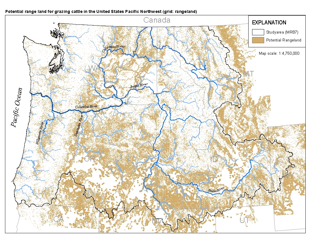
This spatial data set was created by the U.S. Geological Survey (USGS) to represent the extent of land in the Pacific Northwest region of the United States (Hydro Region 17; Major River Basin 7 (MRB7)) that potentially received waste from grazing cattle in 2002.
Solar development has the potential to have widespread impacts on the California desert. Thus, it is important to have as much information as possible regarding the impacts of facilities and related infrastructure on the natural ecosystem and surrounding desert communities, how current policies are influencing development, and how the federal process is working on evaluating solar development applications. This research is detailed in this website. "Renewable Energy in the California Desert: Mechanisms for Evaluating Solar Development on Public Lands" is the result of sixteen months of research conducted by ten graduate students from the University of Michigan School of Natural Resources and Environmen t through...
Types: Map Service,
OGC WFS Layer,
OGC WMS Layer,
OGC WMS Service;
Tags: BMP,
English,
GIS,
Mojave Desert,
OHV,
|

|
