Filters: Tags: ice (X)
29 results (83ms)|
Filters
|

The National Environmental Satellite, Data, and Information Service (NESDIS), part of the National Oceanic and Atmospheric Administration (NOAA), has an extensive history of monitoring snow and ice coverage. Accurate monitoring of global snow and ice cover is a key component in the study of climate and global change as well as daily weather forecasting. By inspecting environmental satellite imagery, analysts from the Satellite Analysis Branch (SAB) at the Office of Satellite Data Processing and Distribution (OSDPD), Satellite Services Division (SSD), created a Northern Hemisphere snow and ice map from November 1966 until the National Ice Center (NIC) took over production in 2008. Initially, the product was produced...
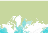
The Multisensor Analyzed Sea Ice Extent – Northern Hemisphere (MASIE-NH) products provide measurements of daily sea ice extent and sea ice edge boundary for the Northern Hemisphere and 16 Arctic regions in a polar stereographic projection. Products include an ASCII text file of sea ice extent values in square km over the entire Northern Hemisphere with 16 separate Arctic regions identified, time series plots of the 16 regions, and image files that visually show where the sea ice is. The MASIE-NH imagery are provided at a nominal 4 km resolution. The input data comes from the 4 km Interactive Multisensor Snow and Ice Mapping System (IMS) snow and ice product produced by the National Ice Center (NIC). NIC utilizes...

The National Environmental Satellite, Data, and Information Service (NESDIS), part of the National Oceanic and Atmospheric Administration (NOAA), has an extensive history of monitoring snow and ice coverage. Accurate monitoring of global snow and ice cover is a key component in the study of climate and global change as well as daily weather forecasting. By inspecting environmental satellite imagery, analysts from the Satellite Analysis Branch (SAB) at the Office of Satellite Data Processing and Distribution (OSDPD), Satellite Services Division (SSD), created a Northern Hemisphere snow and ice map from November 1966 until the National Ice Center (NIC) took over production in 2008. Initially, the product was produced...
Snow and Ice current modeled distribution, and status. These data are provided by Bureau of Land Management (BLM) "as is" and may contain errors or omissions. The User assumes the entire risk associated with its use of these data and bears all responsibility in determining whether these data are fit for the User's intended use. These data may not have the accuracy, resolution, completeness, timeliness, or other characteristics appropriate for applications that potential users of the data may contemplate. The User is encouraged to carefully consider the content of the metadata file associated with these data. The BLM should be cited as the data source in any products derived from these data.
Between 27 and 11 kyr ago, during the last major (Naptowne) glaciation, the northwestern and western Kenai Peninsula and the Cook Inlet trough were covered by ice except for local nunataks and small refugia, like the Caribou Hills. Landforms related to four glacial stades are recognized and paleogeographic maps document ice limits, drainage systems, glacial-impounded lakes, and glaciomarine terraces. Numerous multidisciplinary studies of glacial, vegetation, and insect histories document Holocene climatic changes.

This dataset contains an ice mask for the globe. It is based on a texture class map created by Zobler (1986).

The Multisensor Analyzed Sea Ice Extent – Northern Hemisphere (MASIE-NH) products provide measurements of daily sea ice extent and sea ice edge boundary for the Northern Hemisphere and 16 Arctic regions in a polar stereographic projection. Products include an ASCII text file of sea ice extent values in square km over the entire Northern Hemisphere with 16 separate Arctic regions identified, time series plots of the 16 regions, and image files that visually show where the sea ice is. The MASIE-NH imagery are provided at a nominal 4 km resolution. The input data comes from the 4 km Interactive Multisensor Snow and Ice Mapping System (IMS) snow and ice product produced by the National Ice Center (NIC). NIC utilizes...
This publication contains previously unpublished geochemical analyses or re-analyses of lavas, magmatic inclusions, and a few gabbroic cumulate inclusions from Alaska volcanoes (Akutan, Augustine, Buzzard Creek, Dana, Douglas, Fourpeaked, Frosty, Great Sitkin, Iliamna, Kaguyak, Kiska, Okmok, Prindle Cone, Recheshnoi, Redoubt, Spurr, Ukinrek Maars, Vsevidof, Westdahl, Wrangell) collected by the authors and others over the past 35 years. It provides substantial data sets for three volcanoes (Vsevidof, Westdahl, and Douglas) for which little or no published data exist. All analyses were made by the GeoAnalytical laboratory at Washington State University in Pullman, WA. The ICP/MS data have been reduced using the 2006...

The dataset was created as part of the Tongass National Forest's submission to the National Hydrography Dataset. As the SEAK Hydro database evolves, so to will the metadata for this dataset. Until noted otherwise, please reference this metadata for an older version of the source data. This dataset depicts glaciers in Southeast Alaska.
Glaciers and ice masses for the province of British Columbia, prepared as a part of the Freshwater Atlas.
Types: Map Service,
OGC WFS Layer,
OGC WMS Layer,
OGC WMS Service;
Tags: BC,
British Columbia,
Canada,
Glaciers,
Ice,
During 2009 the Alaska Division of Geological & Geophysical Surveys (DGGS) conducted reconnaissance interpretive mapping of permafrost in Alaska Highway Corridor Segment 3, a 12-mi-wide (19.3-km-wide) corridor that straddles the Alaska Highway through the Northway-Tanacross Lowland and the southern Yukon-Tanana Upland from Tetlin Junction to the Canada border. This work was an extension of permafrost mapping done in Alaska Highway Corridor Segment 1 from Delta Junction to Dot Lake in the Big Delta and Mt. Hayes Quadrangles during 2006-2007 and Alaska Highway Corridor Segment 2 from the Robertson River to Tetlin Junction in the Tanacross Quadrangles during 2008. Primarily, we inferred the extent of permafrost and...
This 1:50,000 scale geologic map describes the distribution of unconsolidated deposits, identifies local geologic hazards, and provides information about the depositional environment and basic engineering properties of common surficial-geologic materials in and around Shaktoolik, Alaska. Map units are the result of combined field observations and aerial imagery interpretation. A suite of local ground observations were collected over a two-week period in July 2011 by a helicopter-supported team of DGGS geologists and collaborators. Field investigations included soil test pits, sample collection, soil and rock description, oblique aerial photography, and documentation of landscape morphology.

The Multisensor Analyzed Sea Ice Extent – Northern Hemisphere (MASIE-NH) products provide measurements of daily sea ice extent and sea ice edge boundary for the Northern Hemisphere and 16 Arctic regions in a polar stereographic projection. Products include an ASCII text file of sea ice extent values in square km over the entire Northern Hemisphere with 16 separate Arctic regions identified, time series plots of the 16 regions, and image files that visually show where the sea ice is. The MASIE-NH imagery are provided at a nominal 4 km resolution. The input data comes from the 4 km Interactive Multisensor Snow and Ice Mapping System (IMS) snow and ice product produced by the National Ice Center (NIC). NIC utilizes...
This report provides detailed (1:63,360-scale) mapping of the Tanana A-1 and A-2 quadrangles (500 square miles; equivalent to eight 7.5-minute quadrangles). The area is part of the Manley Hot Springs-Tofty mining districts and adjacent to the Rampart mining district to the south of the Tanana B-1 Quadrangle. This report includes detailed geologic construction materials and geologic hazards data. The Tanana A-1 and A-2 Quadrangles and surrounding area comprise several isolated mountainous ridges in the western Yukon-Tanana Upland of interior Alaska.
Landsat Extended Acquisitions of the Poles (LEAP) imaging plan is a Landsat special request data collection program for Earth's polar regions that include Antarctica, Greenland, and Arctic sea ice geographies. The LEAP program includes Landsat 8 and Landsat 9 observatories that operationally acquire spaceborne images of all Earth's land surface and near-shore coastal environments. These images are acquired on a Worldwide Reference System-2, also called WRS-2. The WRS-2 is made up of paths and rows that define Landsat's imaged geography, and once acquired, are processed and discoverable in the U.S. Geological Survey's Landsat global data archive. The LEAP path-rows listed in the attached zipped data file represent...

The Multisensor Analyzed Sea Ice Extent – Northern Hemisphere (MASIE-NH) products provide measurements of daily sea ice extent and sea ice edge boundary for the Northern Hemisphere and 16 Arctic regions in a polar stereographic projection. Products include an ASCII text file of sea ice extent values in square km over the entire Northern Hemisphere with 16 separate Arctic regions identified, time series plots of the 16 regions, and image files that visually show where the sea ice is. The MASIE-NH imagery are provided at a nominal 4 km resolution. The input data comes from the 4 km Interactive Multisensor Snow and Ice Mapping System (IMS) snow and ice product produced by the National Ice Center (NIC). NIC utilizes...
Although ice in the Martian mid-latitudes is typically covered by a layer of dust or regolith, it is exposed in some locations by fresh impact craters or in erosional scarps. In both cases, the exposed ice is massive or excess ice with a low lithic content. We find that erosional scarps occur between 50–61 north and south latitude, and that they are concentrated in and near Milankovič crater in the northern hemisphere and southeast of the Hellas basin in the southern hemisphere. These may represent locations of particularly thick or clean bodies of ice. Pits created by retreat of the scarps represent sublimation-thermokarst landforms that evolve in a manner distinct from other ice-loss landforms on Mars. New impact...
This tabular data set represents the presence of six National Hydrography Dataset (NHD) high resolution waterbody types compiled for two spatial components of the NHDPlus version 2 data suite (NHDPlusv2) for the conterminous United States; 1) individual reach catchments and 2) reach catchments accumulated upstream through the river network. The six types of waterbodies presented here are: playa, ice mass, lake/pond, reservoir, swamp/marsh, and estuary. This dataset can be linked to the NHDPlus version 2 data suite by the unique identifier COMID. The source data is the NHDPlus high resolution waterbodies produced by USGS , 2015. Units are percent. Reach catchment information characterizes data at the local scale....
Types: Citation;
Tags: Catchment,
Conterminous United States,
Inlandwaters,
NAWQA,
NHD high resolution waterbodies,

The National Environmental Satellite, Data, and Information Service (NESDIS), part of the National Oceanic and Atmospheric Administration (NOAA), has an extensive history of monitoring snow and ice coverage. Accurate monitoring of global snow and ice cover is a key component in the study of climate and global change as well as daily weather forecasting. By inspecting environmental satellite imagery, analysts from the Satellite Analysis Branch (SAB) at the Office of Satellite Data Processing and Distribution (OSDPD), Satellite Services Division (SSD), created a Northern Hemisphere snow and ice map from November 1966 until the National Ice Center (NIC) took over production in 2008. Initially, the product was produced...

Permafrost extent of Russia, from the Land Resources of Russia collection. Full description of this and accompanying datasets can be found at http://www.iiasa.ac.at/Research/FOR/russia_cd/perm.htm .
|

|
