Filters: Tags: josephine county (X) > partyWithName: Jim Wolf (X)
17 results (27ms)|
Filters
Date Range
Tag Schemes |

2013 Compilation of CWPP's in the Rogue Basin, Oregon, Â including Josephine County, Jackson County, Applegate, City of Ashland, Seven Basins, Illinois Valley, and Colestin

Project boundary for the Greater Grants Pass Community Assistance grant for 2011

The Wildland Urban Interface (WUI) boundary designated in the updated Illinois Valley Community Wildfire Protection Plan (updated June 2011). Follow this link to the plan http://www.ivfire.com/images/documents/2011fpupdate.pdf
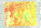
Wildfire Hazard based upon modeled flame length, rate of spread and fire type (surface, passive or actrive crowning) during weahtyer conditions typical of large fire growth in SW Oregon (80th percentile)

Grants Pass, Oregon City Limits
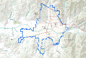
Grants Pass Oregon Urban Growth Boundary

Any Siskiyou Forest land that is a descrete unit boundry with a desired future condition to meet specific resource objectives will be called a managed stand. Information for this layer came from the TRI maps, aerial photos, traverse maps (pre-sale activity cards), ROQ positives, and resource specialists. Information for this layer came from the TRI maps, aerial photos, traverse maps (pre-sale activity cards), ROQ positives, and resource specialists.

Fuels treatment activities for the Rogue River - Siskiyou National Forest from 2001-2009.

2010 Josephine-Jackson County Risk Assessment Composite Wildfire Risk Rating. The rating represents relative risk from lowest to highest risk (1-10). It is a weighted value representing ignition likelihood, wildfire hazard, values at risk, and protection capability.

Desingation of Spotted Owl, Pileated Woodpecker, and Pine Martin areas was a long process which took place from 1984-1991. Documentation of this process can be found in the Siskiyou National Forest, Final Environmental Impact Statement (FEIS), Appendices-Volume I, Appendix B, pages B-83 through B-87

Grants Pass Fire Awareness Public Survey Zones for 2012 publci surveys

Fuels reduction projects funded by National Fire Plan and Community Assistance in SW Oregon. In some cases with projects completed by IVCDO and Lomakatsi, the area treated is smaller than the polygon (entire tax lot selected based upon treatment somewhere on parcel).

Layer contains Fuel Treatment Polygons for the Medford BLM District. Treatments are historical, current and future.

The potential to find a mineral in an area on the Siskiyou National Forest.

Trash sites cleaned up through efforts coordinated by the Clean Forest Project in Josephine County. Information includes pounds of material removed and recycled, description of materials, and owner. Sites with no GPS coordinates were assigned a location in Douglas County (42.0,-123.0).

Project Boundary for North Valley Community Assistance Grant
|

|

