Filters: Tags: nitrogen (X)
348 results (45ms)|
Filters
Date Range
Extensions
Types
Contacts
Categories
Tag Types
|
This dataset is a single comma-delimited text file (.csv). Data include the name of lakes where samples were obtained, soil core dimensions, bulk density, and carbon/nitrogen content of soil core samples within the organic soil horizon in lake-margin wetland plant communities.
Presented by Don Spalinger & Nathan WolfThis seminar focuses on our concepts of regulation of nutrient flows through tundra ecosystems and the effect that climate (or weather) has on these processes. Nutrient flow and climate, in turn, should regulate plant phenology and production, and thus caribou behavior and nutrition. We will present some ideas for assessing the landscape patterns of these processes and monitoring their impacts. Finally, we will provide examples of such assessment and monitoring processes from our work in Western Alaska over the past two years.
Categories: Data;
Tags: ALPINE/TUNDRA,
ALPINE/TUNDRA,
CARBON,
CARBON,
CARBON CYCLE/CARBON BUDGET MODELS,
These data were released prior to the October 1, 2016 effective date for the USGS’s policy dictating the review, approval, and release of scientific data as referenced in USGS Survey Manual Chapter 502.8 Fundamental Science Practices: Review and Approval of Scientific Data for Release. This map shows specific water-quality items and hydrologic data site information which come from QWDATA (Water Quality) and GWSI (Ground Water Information System). Both QWDATA and GWSI are subsystems of NWIS (National Water Inventory System)of the USGS (United States Geologic Survey). This map is for Davis County, Utah. The scope and purpose of NWIS is defined on the web site: http://water.usgs.gov/public/pubs/FS/FS-027-98/

These data were released prior to the October 1, 2016 effective date for the USGS’s policy dictating the review, approval, and release of scientific data as referenced in USGS Survey Manual Chapter 502.8 Fundamental Science Practices: Review and Approval of Scientific Data for Release. This spatial data set was created by the U.S. Geological Survey (USGS) to represent the amount of fertilizer nitrogen and phosphorus that was applied to farm and nonfarm land in the Pacific Northwest region of the United States (Hydro Region 17; Major River Basin 7 (MRB7)) during 2002 within each incremental watershed delineated in the NHDPlus v2 dataset.
These data were released prior to the October 1, 2016 effective date for the USGS’s policy dictating the review, approval, and release of scientific data as referenced in USGS Survey Manual Chapter 502.8 Fundamental Science Practices: Review and Approval of Scientific Data for Release. This map shows specific water-quality items and hydrologic data site information which come from QWDATA (Water Quality) and GWSI (Ground Water Information System). Both QWDATA and GWSI are subsystems of NWIS (National Water Inventory System)of the USGS (United States Geologic Survey). This map is for Grand County, Utah. The scope and purpose of NWIS is defined on the web site: http://water.usgs.gov/public/pubs/FS/FS-027-98/
These data were released prior to the October 1, 2016 effective date for the USGS’s policy dictating the review, approval, and release of scientific data as referenced in USGS Survey Manual Chapter 502.8 Fundamental Science Practices: Review and Approval of Scientific Data for Release. This map shows specific water-quality items and hydrologic data site information which come from QWDATA (Water Quality) and GWSI (Ground Water Information System). Both QWDATA and GWSI are subsystems of NWIS (National Water Inventory System)of the USGS (United States Geologic Survey). This map is for Tooele County, Utah. The scope and purpose of NWIS is defined on the web site: http://water.usgs.gov/public/pubs/FS/FS-027-98/

These data were released prior to the October 1, 2016 effective date for the USGS’s policy dictating the review, approval, and release of scientific data as referenced in USGS Survey Manual Chapter 502.8 Fundamental Science Practices: Review and Approval of Scientific Data for Release. This spatial data set was created by the U.S. Geological Survey (USGS) to represent the amount of wet deposition of oxidized nitrogen in the Pacific Northwest region of the United States (Hydro Region 17; Major River Basin 7 (MRB7)) during 2002.
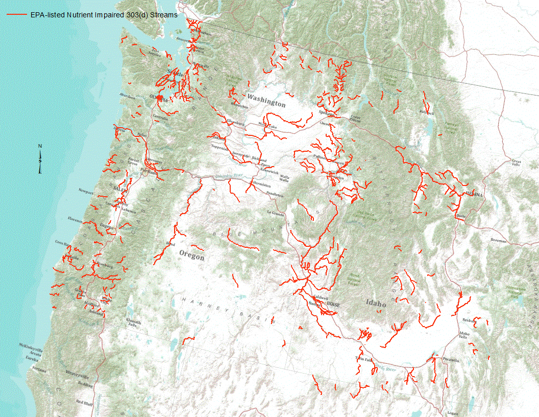
“Under section 303(d) of the 1972 Clean Water Act, states, territories, and authorized tribes are required to develop lists of impaired waters. These impaired waters do not meet water quality standards that states, territories, and authorized tribes have set for them, even after point sources of pollution have installed the minimum required levels of pollution control technology. The law requires that these jurisdictions establish priority rankings for waters on the lists and develop TMDLs for these waters” (U.S. Environmental Protection Agency, 2011). Waterways represented in this data set are a subset of these EPA 303 (d) listed streams that were classified as nutrient impaired. Nutrient impaired streams include...
This metadata record documents an ascii comma-delimited file representing estimated nitrogen in kilograms by NHDPlus v2.1 catchments for the conterminous United States. Nitrogen estimates were taken from Estimated nitrogen from septic for the conterminous United States, 2010 published by the U.S. Geological Survey. Nitrogen values by individual reach catchments (COMID) were determined by calculating a zonal mean in a GIS.
This location is part of the Arizona Mineral Industry Location System (AzMILS), an inventory of mineral occurences, prospects and mine locations in Arizona. Pinal386 is located in T6S R18E Sec 24 E2 in the Booger Canyon - 7.5 Min quad. This collection consists of various reports, maps, records and related materials acquired by the Arizona Department of Mines and Mineral Resources regarding mining properties in Arizona. Information was obtained by various means, including the property owners, exploration companies, consultants, verbal interviews, field visits, newspapers and publications. Some sections may be redacted for copyright. Please see the access statement.
Categories: Data;
Tags: 1950s,
Aravaipa Canyon physiographic area,
Arizona,
Booger Canyon - 7.5 Min,
Dataset,
Leaf ecophysiological traits related to carbon gain and resource use are expected to be under strong selection in desert annuals. We used comparative and phenotypic selection approaches to investigate the importance of leaf ecophysiological traits for Helianthus anomalus, a diploid annual sunflower species of hybrid origin that is endemic to active desert dunes. Comparisons were made within and among five genotypic classes: H. anomalus, its ancestral parent species (H. annuus and H. petiolaris), and two backcrossed populations of the parental species (designated BC2ann and BC2pet) representing putative ancestors of H. anomalus. Seedlings were transplanted into H. anomalus habitat at Little Sahara Dunes, Utah, and...
Categories: Publication;
Types: Citation,
Journal Citation;
Tags: Carbon isotope discrimination,
Evolution,
fitness,
leaf area,
nitrogen,
Nitric oxide (NO) is a relatively short-lived trace gas that reacts with oxygen in the troposphere to produce the air pollutant ozone. It also reacts with water vapor to form nitric and nitrous acids, which acidify precipitation and increase N deposition. Models currently used to predict soil NO fluxes are based on the assumption that NO flux is proportional to the gross rate of nitrification or N mineralization; however, this assumption has not been tested because of the difficulty in measuring gross N-cycling rates in situ. We measured soil NO fluxes, gross and net N-cycling rates, and a variety of other soil characteristics in the forest floor and intact soil cores at nine undisturbed forest and rangeland ecosystems...
Categories: Publication;
Types: Citation,
Journal Citation;
Tags: 15N,
Ecology,
N mineralization,
Oregon Transect Ecosystem Research (OTTER) transec,
gross N-cycling rates,
Although freeze–thaw cycles can alter soil physical properties and microbial activity, their overall impact on soil functioning remains unclear. This review addresses the effects of freeze–thaw cycles on soil physical properties, microorganisms, carbon and nutrient dynamics, trace gas losses and higher organisms associated with soil. I discuss how the controlled manipulation of freeze–thaw cycles has varied widely among studies and propose that, despite their value in demonstrating the mechanisms of freeze–thaw action in soils, many studies of soil freeze–thaw cycles have used cycle amplitudes, freezing rates and minimum temperatures that are not relevant to temperature changes across much of the soil...
Categories: Publication;
Types: Citation,
Journal Citation;
Tags: Soil Biology and Biochemistry,
carbon,
climate,
freeze–thaw cycle,
microbial biomass,
Geostatistical analyses show that the distribution of soil N, P and K is strongly associated with the presence of shrubs in desert habitats. Shrubs concentrate the biogeochemical cycle of these elements in ?islands of fertility? that are localized beneath their canopies, while adjacent barren, intershrub spaces are comparatively devoid of biotic activity. Both physical and biological processes are involved in the formation of shrub islands. Losses of semiarid grassland in favor of invading shrubs initiate these changes in the distribution of soil nutrients, which may promote the further invasion and persistence of shrubs and cause potential feedbacks between desertification and the Earth's climate system. Published...
Categories: Publication;
Types: Citation,
Journal Citation;
Tags: Biogeochemistry,
Larrea tridentata,
Prosopis glandulosa,
Springer Netherlands,
aridisols,

Estimated nitrogen delivered to the estuaries along the Gulf of Mexico (U.S. only). Delivered yield is an estimate of the amount of nitrogen delivered to an estuary divided by the area of the upstream drainage area that drains into the estuary. Units are kg/km2/year.
A cvs file containing field datasets used to develop regression models to predict sediment and nutrient retention services for stream within the Difficult Run watershed. Field measurements of floodplain deposition and bank erosion were provided in previously published datasets from Hupp et al. (2013) and Gellis et al. (2017). At each field site 3-5 nearby cross-sections from the Toolbox where used to represent the floodplain and streambank sampling locations at the field sites. Metrics derived from the Toolbox are provided in this data table.
Categories: Data;
Types: Map Service,
OGC WFS Layer,
OGC WMS Layer,
OGC WMS Service;
Tags: Difficult Run,
Fairfax County,
Flood plains,
Fluvial morphology,
Virginia,
This paper contrasts the natural and anthropogenic controls on the conversion of unreactive N2 to more reactive forms of nitrogen (Nr). A variety of data sets are used to construct global N budgets for 1860 and the early 1990s and to make projections for the global N budget in 2050. Regional N budgets for Asia, North America, and other major regions for the early 1990s, as well as the marine N budget, are presented to Highlight the dominant fluxes of nitrogen in each region. Important findings are that human activities increasingly dominate the N budget at the global and at most regional scales, the terrestrial and open ocean N budgets are essentially disconnected, and the fixed forms of N are accumulating in most...
Categories: Publication;
Types: Citation,
Journal Citation;
Tags: Biogeochemistry,
Denitrification,
Fertilizer,
Fossil fuel combustion,
Haber-Bosch,
This study investigated how CO2and temperature affect dry weight (d.wt) accumulation, total nonstructural carbohydrate (TNC) concentration, and partitioning of C and N among organs of two important grasses of the shortgrass steppe,Pascopyrum smithii Rydb. (C3) andBouteloua gracilis(H.B.K.) Lag. ex Steud. (C4). Treatment combinations comprised two temperatures (20 and 35�C) at two concentrations of CO2(380 and 750 ?mol mol-1), and two additional temperatures of 25 and 30�C at 750 ?mol mol-1CO2. Plants were maintained under favourable nutrient and soil moisture and harvested following 21, 35, and 49d of treatment. CO2-induced growth enhancements were greatest at temperatures considered favourable for growth of these...
Categories: Publication;
Types: Citation,
Journal Citation;
Tags: Annals of Botany,
Bouteloua gracilis,
N uptake,
Pascopyrum smithii,
acclimation to CO2,
Although freeze?thaw cycles can alter soil physical properties and microbial activity, their overall impact on soil functioning remains unclear. This review addresses the effects of freeze?thaw cycles on soil physical properties, microorganisms, carbon and nutrient dynamics, trace gas losses and higher organisms associated with soil. I discuss how the controlled manipulation of freeze?thaw cycles has varied widely among studies and propose that, despite their value in demonstrating the mechanisms of freeze?thaw action in soils, many studies of soil freeze?thaw cycles have used cycle amplitudes, freezing rates and minimum temperatures that are not relevant to temperature changes across much of the soil profile in...
Categories: Publication;
Types: Citation,
Journal Citation;
Tags: Soil Biology and Biochemistry,
carbon,
climate,
freeze?thaw cycle,
microbial biomass,
This dataset contains catchment-level estimates of nitrogen and phosphorus fertilizer use, for agricultural lands, for the conterminous U.S., for 2012. An approach was developed to relate farm commercial fertilizer sales data from the Association of American Plant Food Control Officials (AAPFCO) to a set of explanatory variables using spatially-referenced modeling methods. Separate models for nitrogen and phosphorus are developed to estimate elemental fertilizer use on agricultural lands for the conterminous U.S. at the National Hydrography Dataset Plus version 2 (NHDPlusV2) catchment scale. The approach builds on earlier efforts that use Association of American Plant Food Control Officials (AAPFCO) data on fertilizer...
|

|
