Filters: Tags: nlcd (X)
109 results (41ms)|
Filters
Date Range
Extensions (Less) Types (Less)
Contacts (Less)
Categories (Less) Tag Types
|

This dataset portrays land cover for north-central Alaska, part of NLCD superzone 15. To reduce file size, Alaska was divided into ten zones, which can be found in the NLCD 2001 gallery . For more infomation on NLCD superzones, including a map, refer to http://www.mrlc.gov/nlcd_multizone_map.php . From NLCD: The National Land Cover Database 2001 was produced through a cooperative project conducted by the Multi-Resolution Land Characteristics (MRLC) Consortium. The MRLC Consortium is a partnership of federal agencies (www.mrlc.gov), consisting of the U.S. Geological Survey (USGS), the National Oceanic and Atmospheric Administration (NOAA), the U.S. Environmental Protection Agency (EPA), the U.S. Department of Agriculture...

National Land Cover Database 2001 (NLCD2001) is a 16-class (additional four classes in Alaska only) land cover classification scheme that has been applied consistently across all 50 United States and Puerto Rico at a spatial resolution of 30 meters. NLCD2001 is based primarily on the unsupervised classification of Landsat Enhanced Thematic Mapper+ (ETM+) circa 2001 satellite data. NLCD2001 improves on NLCD92 in that it is comprised of three different elements: land cover, percent developed impervious surface and percent tree canopy density. NLCD2001 also uses improved classification algorithms, which have resulted in data with more precise rending of spatial boundaries between the land cover classes.

This dataset portrays land cover for Puerto Rico, which is NLCD mapping superzone seventeen. Refer to http://www.mrlc.gov/nlcd_multizone_map.php for a map of the superzones. From NLCD: The National Land Cover Database 2001 was produced through a cooperative project conducted by the Multi-Resolution Land Characteristics (MRLC) Consortium. The MRLC Consortium is a partnership of federal agencies (www.mrlc.gov), consisting of the U.S. Geological Survey (USGS), the National Oceanic and Atmospheric Administration (NOAA), the U.S. Environmental Protection Agency (EPA), the U.S. Department of Agriculture (USDA), the U.S. Forest Service (USFS), the National Park Service (NPS), the U.S. Fish and Wildlife Service (FWS),...

This dataset portrays land cover for NLCD mapping superzone five, covering most of Arizona, a large portion of western New Mexico, and very small portions of Utah, Colorado, and Texas. Refer to http://www.mrlc.gov/nlcd_multizone_map.php for a map of the super-zones. From NLCD: The National Land Cover Database 2001 was produced through a cooperative project conducted by the Multi-Resolution Land Characteristics (MRLC) Consortium. The MRLC Consortium is a partnership of federal agencies (www.mrlc.gov), consisting of the U.S. Geological Survey (USGS), the National Oceanic and Atmospheric Administration (NOAA), the U.S. Environmental Protection Agency (EPA), the U.S. Department of Agriculture (USDA), the U.S. Forest...
Tags: land cover,
nlcd

Forest cover types (deciduous forest (41), evergreen forest (42), mixed forest (43), shrub/scrub (52), woody wetland (90)) were isolated from the 2001 National Land Cover Dataset (1 = forest, 0 = non-forest). To improve processing time of running a large focal mean across an expansive region, the “aggregate” tool was applied to the forest grid and re-sampled the 30 m pixels to 90 m using the mean aggregate option (i.e., the result is new 90 m pixels representing the proportion of forest in 9 pixels). A 10 km circular focal mean was applied to the aggregated grid resulting in a new floating point raster containing the proportion of forest within 10 km of each 90 m pixel. These values were multiplied by 100, rounded...
The NHDPlus Version 1.0 is an integrated suite of application-ready geospatial data sets that incorporate many of the best features of the National Hydrography Dataset (NHD) and the National Elevation Dataset (NED). The NHDPlus includes a stream network (based on the 1:100,000-scale NHD), improved networking, naming, and "value-added attributes" (VAA's). NHDPlus also includes elevation-derived catchments (drainage areas) produced using a drainage enforcement technique first broadly applied in New England, and thus dubbed "The New-England Method". This technique involves "burning-in" the 1:100,000-scale NHD and when available building "walls" using the national Watershed Boundary Dataset (WBD). The resulting modified...
The National Land Cover Database (NLCD) is a land cover monitoring program providing land cover information for the United States. NLCD2016 extended temporal coverage to 15 years (2001–2016). We collected land cover reference data for the 2011 and 2016 nominal dates to report land cover accuracy for the NLCD2016 database 2011 and 2016 land cover components. We measured land cover accuracy at Level II and Level I, and change accuracy at Level I. For both the 2011 and 2016 land cover components, single-date Level II overall accuracies (OA) were 72% (standard error of ±0.9%) when agreement was defined as match between the map label and primary reference label only and 86% (± 0.7%) when agreement also included the alternate...

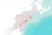
This dataset portrays land cover for NLCD mapping superzone thirteen, which covers all of Maine, Vermont, New Hampshire, Massachusetts, Rhode Island, Connecticut, New York, New Jersey, Delaware, and Maryland, and parts of Pennsylvania, Virginia, West Virginia, and North Carolina. Refer to http://www.mrlc.gov/nlcd_multizone_map.php for a map of the superzones. From NLCD: The National Land Cover Database 2001 was produced through a cooperative project conducted by the Multi-Resolution Land Characteristics (MRLC) Consortium. The MRLC Consortium is a partnership of federal agencies (www.mrlc.gov), consisting of the U.S. Geological Survey (USGS), the National Oceanic and Atmospheric Administration (NOAA), the U.S....
This dataset portrays percent imperviousness surface area for NLCD mapping superzone thirteen, which covers all of Maine, Vermont, New Hampshire, Massachusetts, Rhode Island, Connecticut, New York, New Jersey, Delaware, and Maryland, and parts of Pennsylvania, Virginia, West Virginia, and North Carolina. Refer to http://www.mrlc.gov/nlcd_multizone_map.php for a map of the super-zones. From NLCD: The National Land Cover Database 2001 was produced through a cooperative project conducted by the Multi-Resolution Land Characteristics (MRLC) Consortium. The MRLC Consortium is a partnership of federal agencies (www.mrlc.gov), consisting of the U.S. Geological Survey (USGS), the National Oceanic and Atmospheric Administration...

This dataset portrays land cover for southwestern Alaska, part of NLCD superzone 15. To reduce file size, Alaska was divided into ten zones, which can be found in the NLCD 2001 gallery . For more infomation on NLCD superzones, including a map, refer to http://www.mrlc.gov/nlcd_multizone_map.php . From NLCD: The National Land Cover Database 2001 was produced through a cooperative project conducted by the Multi-Resolution Land Characteristics (MRLC) Consortium. The MRLC Consortium is a partnership of federal agencies (www.mrlc.gov), consisting of the U.S. Geological Survey (USGS), the National Oceanic and Atmospheric Administration (NOAA), the U.S. Environmental Protection Agency (EPA), the U.S. Department of Agriculture...

This dataset portrays percent imperviousness surface area for NLCD mapping superzone twelve, which covers most of Mississippi and Alabama, and parts of Louisiana, Florida, Georgia, Tennessee, Arkansas, and Missouri. Refer to http://www.mrlc.gov/nlcd_multizone_map.php for a map of the super-zones. From NLCD: The National Land Cover Database 2001 was produced through a cooperative project conducted by the Multi-Resolution Land Characteristics (MRLC) Consortium. The MRLC Consortium is a partnership of federal agencies (www.mrlc.gov), consisting of the U.S. Geological Survey (USGS), the National Oceanic and Atmospheric Administration (NOAA), the U.S. Environmental Protection Agency (EPA), the U.S. Department of Agriculture...

This dataset portrays percent imperviousness surface area for NLCD mapping superzone three, covering most of Idaho, a large part of Montana, and small portions of Wyoming, Nevada, Washington, and Oregon. Refer to http://www.mrlc.gov/nlcd_multizone_map.php for a map of the super-zones. From NLCD: The National Land Cover Database 2001 was produced through a cooperative project conducted by the Multi-Resolution Land Characteristics (MRLC) Consortium. The MRLC Consortium is a partnership of federal agencies (www.mrlc.gov), consisting of the U.S. Geological Survey (USGS), the National Oceanic and Atmospheric Administration (NOAA), the U.S. Environmental Protection Agency (EPA), the U.S. Department of Agriculture (USDA),...
As part of the next generation NLCD 2016 mapping process, the NLCD research team developed a suite of intermediate products that were used to generate the final NLCD Land Cover products. Some of those products also have value as independent products and are provided here. Please read the product descriptions to understand what the product represents. Questions about the NLCD 2016 land cover product can be directed to the NLCD 2016 land cover mapping team at USGS EROS, Sioux Falls, SD (605) 594-6151 or mrlc@usgs.gov. See included spatial metadata for more details.
Types: Map Service,
OGC WFS Layer,
OGC WMS Layer,
OGC WMS Service;
Tags: GIS,
Image processing,
Land Use Land Cover Theme,
Land cover,
N.L.C.D.,

These data were released prior to the October 1, 2016 effective date for the USGS’s policy dictating the review, approval, and release of scientific data as referenced in USGS Survey Manual Chapter 502.8 Fundamental Science Practices: Review and Approval of Scientific Data for Release. This 30-meter resolution data set represents the imperviousness layer for the conterminous United States for the 2001 time period. The data have been arranged into four tiles to facilitate timely display and manipulation within a Geographic Information System, browse graphic: nlcd01-partition. The National Land Cover Data Set for 2001 was produced through a cooperative project conducted by the Multi-Resolution Land Characteristics...

These data were released prior to the October 1, 2016 effective date for the USGS’s policy dictating the review, approval, and release of scientific data as referenced in USGS Survey Manual Chapter 502.8 Fundamental Science Practices: Review and Approval of Scientific Data for Release. This 30-meter data set represents land use and land cover for the conterminous United States for the 2001 time period. The data have been arranged into four tiles to facilitate timely display and manipulation within a Geographic Information System see https://www.sciencebase.gov/catalog/file/get/631405cad34e36012efa3295?name=nlcd01-partitions.jpg. The National Land Cover Data Set for 2001 was produced through a cooperative project...

This dataset portrays percent imperviousness surface area for NLCD mapping superzone eleven, which covers most of Illinois, Indiana, Ohio, and Kentucky, and parts of West Virginia, Tennessee, Pennsylvania, Virginia, Michigan and Wisconsin. Refer to http://www.mrlc.gov/nlcd_multizone_map.php for a map of the super-zones. From NLCD: The National Land Cover Database 2001 was produced through a cooperative project conducted by the Multi-Resolution Land Characteristics (MRLC) Consortium. The MRLC Consortium is a partnership of federal agencies (www.mrlc.gov), consisting of the U.S. Geological Survey (USGS), the National Oceanic and Atmospheric Administration (NOAA), the U.S. Environmental Protection Agency (EPA), the...

This dataset portrays land cover for northwestern Alaska, part of NLCD superzone 15. To reduce file size, Alaska was divided into ten zones, which can be found in the NLCD 2001 gallery . For more infomation on NLCD superzones, including a map, refer to http://www.mrlc.gov/nlcd_multizone_map.php . From NLCD: The National Land Cover Database 2001 was produced through a cooperative project conducted by the Multi-Resolution Land Characteristics (MRLC) Consortium. The MRLC Consortium is a partnership of federal agencies (www.mrlc.gov), consisting of the U.S. Geological Survey (USGS), the National Oceanic and Atmospheric Administration (NOAA), the U.S. Environmental Protection Agency (EPA), the U.S. Department of Agriculture...

This dataset portrays land cover for south-central Alaska, part of NLCD superzone 15. To reduce file size, Alaska was divided into ten zones, which can all be found in the NLCD 2001 gallery . For more infomation on NLCD superzones, including a map, refer to http://www.mrlc.gov/nlcd_multizone_map.php . From NLCD: The National Land Cover Database 2001 was produced through a cooperative project conducted by the Multi-Resolution Land Characteristics (MRLC) Consortium. The MRLC Consortium is a partnership of federal agencies (www.mrlc.gov), consisting of the U.S. Geological Survey (USGS), the National Oceanic and Atmospheric Administration (NOAA), the U.S. Environmental Protection Agency (EPA), the U.S. Department...

This dataset portrays land cover for NLCD mapping superzone six, cover North and South Dakota and parts of Nebraska, Wyoming, Montana, Minnesota, and Iowa. Refer to http://www.mrlc.gov/nlcd_multizone_map.php for a map of the super-zones. From NLCD: The National Land Cover Database 2001 was produced through a cooperative project conducted by the Multi-Resolution Land Characteristics (MRLC) Consortium. The MRLC Consortium is a partnership of federal agencies (www.mrlc.gov), consisting of the U.S. Geological Survey (USGS), the National Oceanic and Atmospheric Administration (NOAA), the U.S. Environmental Protection Agency (EPA), the U.S. Department of Agriculture (USDA), the U.S. Forest Service (USFS), the National...
Tags: land cover,
nlcd

This dataset portrays percent imperviousness surface area for NLCD mapping superzone ten, which covers parts of Texas, Louisiana, Arkansas, Oklahoma, and Kansas. Refer to http://www.mrlc.gov/nlcd_multizone_map.php for a map of the super-zones. From NLCD: The National Land Cover Database 2001 was produced through a cooperative project conducted by the Multi-Resolution Land Characteristics (MRLC) Consortium. The MRLC Consortium is a partnership of federal agencies (www.mrlc.gov), consisting of the U.S. Geological Survey (USGS), the National Oceanic and Atmospheric Administration (NOAA), the U.S. Environmental Protection Agency (EPA), the U.S. Department of Agriculture (USDA), the U.S. Forest Service (USFS), the...
|

|
