Filters: Tags: pacific northwest (X)
483 results (86ms)|
Filters
Date Range
Extensions
Types
Contacts
Categories Tag Types
|
This update was provided to FWS on March 21, 2013. The assessment incorporates an evaluation of climate and non-climate threats, and potential interactions among them to evaluate potential bull trout persistence. In summary, it includes the following steps: 1) Map suitable habitat "patches" across the species' range in the conterminous United States; 2) Attribute patches with information on local and climate related threats; 3) Map and attribute migratory habitats for the species and their relationship to "patches;" and 4) model persistence of bull trout in relation to local and climate related threats in patches and migratory habitats. For more information, contact Jason Dunham, U.S. Geological Survey, Forest...
Categories: Publication;
Types: Citation;
Tags: Bull Trout,
Climate Change,
Data Visualization & Tools,
Fish,
Northwest CASC,
This dataset provides point locations of wetlands in the channeled scablands of Washington State. It was created through object based image analysis of high resolution imagery from 2006 and 2009. Each wetland location has an associated surface water hydrograph constructed from spectral mixture analysis of Landsat satellite imagery (1983 – 2011). Hydrologic data is stored in an associated csv file and can be linked to the data through a unique identifier (Wetland_ID). Additionally, individual surface water hydrographs for wetlands, in jpeg format, can be linked to wetland location through the unique identifier.
Research has suggested that biochar soil amendments have the ability to improve soil water retention, but results have not been consistent or predictable across soil types. The objective of this project was to evaluate the potential for biochar soil amendments to mitigate agricultural drought by characterizing their impacts on soil hydraulics and plant growth across a range of agricultural soil conditions. This data set contains soil moisture retention curves and unsaturated hydraulic conductivities for four Oregon agricultural soils amended with biochar. Gasified biochars made from wheat straw (AgEnergy, Spokane, WA) and conifer wood (BioLogical, Philomath, OR) were tilled into soils at experimental stations in...
Categories: Data;
Tags: Drought,
Drought, Fire and Extreme Weather,
Drought, Fire and Extreme Weather,
Klamath Falls,
Landscapes,
We evaluated sagebrush on 24 post-fire seeding sites encompassing >50,000 acres on the Snake River Plain in the Northern Great Basin, specifically in southwest Idaho. Sites were initially identified using the Land Treatment Digital Library (LTDL; http://greatbasin.wr.usgs.gov/ltdl/; and Inciweb fire information (http://inciweb.nwcg.gov/) websites to identify seeding projects located in predominantly Wyoming big sagebrush sites (2,500 to 4,000 feet ASL; 2 sites also had A.t. vaseyana, 2 other sites had only A.t. vaseyana) that (1) had burned and were seeded within the year following fire, from 1987-2010, (2) but had not burned since, and (3) had information on seed sources. Standard USDA species abbreviations are...
Categories: Data;
Tags: Big wyoming sagebrush,
Grasslands and Plains,
Great Basin,
Idaho,
Landscapes,
The U.S. Geological Survey (USGS) has developed the PRObability of Streamflow PERmanence (PROSPER) model, a GIS raster-based empirical model that provides streamflow permanence probabilities (probabilistic predictions) of a stream channel having year-round flow for any unregulated and minimally-impaired stream channel in the Pacific Northwest region, U.S. The model provides annual predictions for 2004-2016 at a 30-m spatial resolution based on monthly or annually updated values of climatic conditions and static physiographic variables associated with the upstream basin (Raw streamflow permanence probability rasters). Predictions correspond to pixels on the channel network consistent with the medium resolution National...
Dreissenid mussel eDNA results for streamgage water samples in the Columbia and Colorado River basin
Environmental DNA results for water samples collected at USGS streamgages in the Columbia and Colorado river basins. Water samples were collected by USGS hydrologic technicians May - September 2018 and analyzed for presence of dreissenid mussel DNA. In this dataset, we report quantitative PCR results for each streamgage location.
Environmental DNA quantitative PCR results for water samples collected in 2018 at USGS streamgages downstream of Columbia River Basin reservoirs that are considered to have moderate to high suitability for invasive dreissenid mussels. Water samples were tested for DNA of dreissenid mussels, kokanee salmon, and yellow perch. This is version 1.1 of this data release. The Kokanee_Perch_eDNA data and metadata files have been revised to correct for improper attribution of 16 samples. For access to previous versions, please contact the Point of Contact identified on this page. First Posted March 29, 2019 Revised July 19, 2019, ver 1.1
Categories: Data,
Data Release - Revised;
Tags: Aquatic Biology,
Ecology,
Pacific Northwest,
Snake River,
USGS Science Data Catalog (SDC),
These data are intended for use in a variety of applications where fish distribution and activity is important. Note that the StreamNet database contains distribution information for numerous species. Within the source database, overlap does not exist for a particular species/run/subrun combination. See information under the spatial process log for specific information regarding the query that was used to construct this particular feature class.
Categories: Data;
Types: Downloadable,
Map Service,
OGC WFS Layer,
OGC WMS Layer,
OGC WMS Service,
Shapefile;
Tags: Anadromous Resources,
Chinook salmon,
Chum,
Coho,
Effects of changes in hydrologic regimes on anadromous fish,
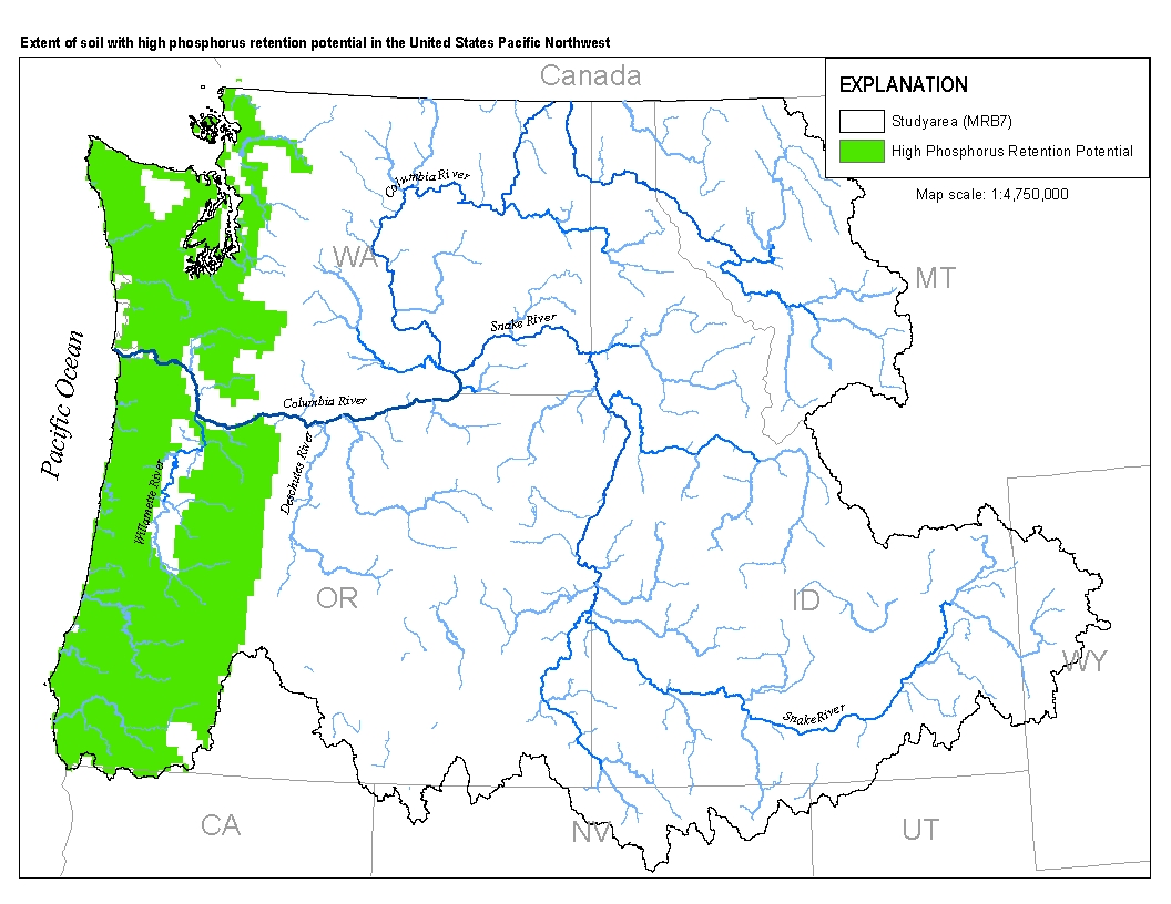
This spatial data set was created by the U.S. Geological Survey (USGS) to represent the extent of soils with high phosphorus retention potential in the Pacific Northwest region of the United States (Hydro Region 17; Major River Basin 7 (MRB7)).
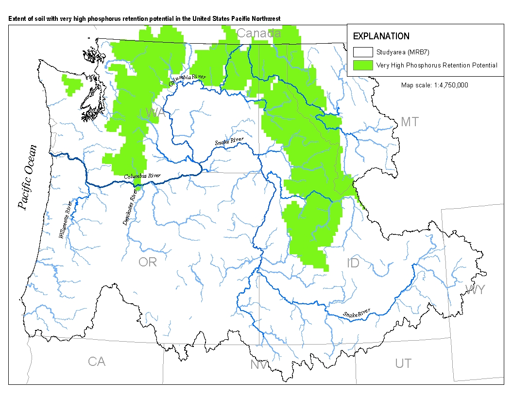
This spatial data set was created by the U.S. Geological Survey (USGS) to represent the extent of soils with very high levels of phosphorus retention potential in the Pacific Northwest region of the United States (Hydro Region 17; Major River Basin 7 (MRB7)).
For his MS thesis, Brendan Rogers used the vegetation model MC1 to simulate vegetation dynamics, associated carbon and nitrogen cycle, water budget and wild fire impacts across the western 2/3 of the states of Oregon and Washington using climate input data from the PRISM group (Chris Daly, OSU) at a 30arc second (800m) spatial grain. The model was run from 1895 to 2100 assuming that nitrogen demand from the plants was always met so that the nitrogen concentrations in various plant parts never dropped below their minimum reported values. A CO2 enhancement effect increased productivity and water use efficiency as the atmospheric CO2 concentration increased. Future climate change scenarios were generated through statistical...
This GIS dataset is part of a suite of wildlife habitat connectivity data produced by the Washington Wildlife Habitat Connectivity Working Group (WHCWG). The WHCWG is a voluntary public-private partnership between state and federal agencies, universities, tribes, and non-governmental organizations. The WHCWG is co-led by the Washington Department of Fish and Wildlife (WDFW) and the Washington Department of Transportation (WSDOT). This dataset quantifies current wildlife habitat connectivity patterns for the Columbia Plateau Ecoregion in Washington, Oregon, and Idaho. Available WHCWG raster data include model base layers, resistance, habitat, cost-weighted distance, and landscape integrity. Grid cell size is 90 m...
In 2016, the U.S. Army Corps of Engineers (USACE) started collecting high-resolution multibeam echosounder (MBES) data on Lake Koocanusa. The survey originated near the International Boundary (River Mile (RM) 271.0) and extended down the reservoir, hereinafter referred to as downstream, about 1.4 miles downstream of the Montana 37 Highway Bridge near Boulder Creek (about RM 253). USACE continued the survey in 2017, completing a reach that extended from about RM 253 downstream to near Tweed Creek (RM 244.5). In 2018, the U.S. Geological Survey (USGS) Idaho Water Science Center completed the remaining portion of the reservoir from RM 244.5 downstream to Libby Dam (RM 219.9). The MBES data collected in 2016 and 2017...
Sandy ocean beaches are a popular recreational destination, often surrounded by communities containing valuable real estate. Development is on the rise despite the fact that coastal infrastructure is subjected to flooding and erosion. As a result, there is an increased demand for accurate information regarding past and present shoreline changes. To meet these national needs, the Coastal and Marine Geology Program of the U.S. Geological Survey (USGS) is compiling existing reliable historical shoreline data along open-ocean sandy shores of the conterminous United States and parts of Alaska and Hawaii under the National Assessment of Shoreline Change project.There is no widely accepted standard for analyzing shoreline...
Categories: Data;
Types: ArcGIS REST Map Service,
ArcGIS Service Definition,
Downloadable,
Map Service;
Tags: Accretion,
CMGP,
Cascade Longview,
Coastal and Marine Geology Program,
Columbia River,
The Province of British Columbia, Ministry of Forests, Lands, & Natural Resource Operations, in partnership with Simon Fraser University and the Alaska Coastal Rainforest Center, led a third workshop to develop cross-boundary geospatial and climate data sets in support of regional conservation applications across NPLCC international boundaries. The workshop will provide opportunities for communicating and discussing priorities for the exchange, development and unification of geospatial and climate datasets.
Categories: Data,
Project;
Types: Map Service,
OGC WFS Layer,
OGC WMS Layer,
OGC WMS Service;
Tags: AK-0,
Academics & scientific researchers,
Alaska,
B.C. North Cascades,
B.C. North Cascades,
This project developed hydrologic projections for diverse wetland habitats (e.g. forest wetlands, wet meadows, small ponds, and riparian wetlands) in the Pacific Northwest (PNW) for the 2020s, 2040s, and 2080s, which can be used to support ecological and landscape-based vulnerability assessments and climate change adaptation planning. The project leveraged existing downscaled climate model scenarios and associated hydrologic datasets developed under separate funding and extended them to examine changes in aquatic habitat.Products developed in this research include new hydroclimatic datasets for assessing changes in the hydroperiod of PNW wetlands. These products are useful to land managers in forecasting ecosystem...
Categories: Data,
Project;
Types: Map Service,
OGC WFS Layer,
OGC WMS Layer,
OGC WMS Service;
Tags: 2011,
Academics & scientific researchers,
Conservation NGOs,
Conservation Planning,
Conservation Planning,
Wetlands in the remote mountains of the western US have undergone two massive ecological “experiments” spanning the 20th century. Beginning in the late 1800s and expanding after World War II, fish and wildlife managers intentionally introduced millions of predatory trout (primarily Oncorhynchus spp) into fishless mountain ponds and lakes across the western states. These new top predators, which now occupy 95% of large mountain lakes, have limited the habitat distributions of native frogs, salamanders, and wetland invertebrates to smaller, more ephemeral ponds where trout do not survive. Now a second “experiment” – anthropogenic climate change – threatens to eliminate many of these ephemeral habitats and shorten...

Derives forest cover percentage from 33x aggregation of NLCD 2006 classes 41, 42, and 43. Results in log-transformed values representing 0-100% cover

For a description of each map layer, select the Details tab, then select a Layer Name. This GIS dataset is part of a suite of wildlife habitat connectivity data produced by the Washington Wildlife Habitat Connectivity Working Group (WHCWG). The WHCWG is a voluntary public-private partnership between state and federal agencies, universities, tribes, and non-governmental organizations. The WHCWG is co-led by the Washington Department of Fish and Wildlife (WDFW) and the Washington Department of Transportation (WSDOT). This dataset quantifies current wildlife habitat connectivity patterns for the Columbia Plateau Ecoregion in Washington, Oregon, and Idaho. Available WHCWG raster data include model base layers, resistance,...
We studied the short-term effects of full and partial livestock grazing exclosures on Columbia Spotted Frog (CSF; Rana luteiventris) populations using a controlled manipulative field experiment with pre- and post-treatment data. This dataset includes vegetation data collected 2002-2010 and 2013 at 94 lakes and ponds in and around the Blue Mountains in eastern Oregon. Data collection followed standardized survey protocols and included annual oviposition surveys and vegetation surveys. These data allowed for quantification of CSF breeding as related to vegetation within and outside of grazing exclosures at each site.
Categories: Data;
Types: Citation;
Tags: Aquatic Biology,
Aquatic ecology,
Baker County,
Blue Mountains,
Ecology,
|

|
