Filters: Tags: ph (X) > partyWithName: U.S. Geological Survey (X)
45 results (11ms)|
Filters
Date Range
Extensions Types
Contacts
Categories Tag Types Tag Schemes |
This data set depicts soil characteristics in western North America. The data set was created from NRCS STATSGO soil data. Calculations were made to reduce one to many relationships to one to one relationships in order to summarize average water capacity, depth to rock, salinity, and pH for each map unit (MUID). ArcMap 8.3 was used to import .dbf files and merge newly created attribute fields to the GIS soil coverage.
These data were released prior to the October 1, 2016 effective date for the USGS’s policy dictating the review, approval, and release of scientific data as referenced in USGS Survey Manual Chapter 502.8 Fundamental Science Practices: Review and Approval of Scientific Data for Release. This map shows specific water-quality items and hydrologic data site information which come from QWDATA (Water Quality) and GWSI (Ground Water Information System). Both QWDATA and GWSI are subsystems of NWIS (National Water Inventory System)of the USGS (United States Geologic Survey). This map is for Uintah County, Utah. The scope and purpose of NWIS is defined on the web site: http://water.usgs.gov/public/pubs/FS/FS-027-98/
These data were released prior to the October 1, 2016 effective date for the USGS’s policy dictating the review, approval, and release of scientific data as referenced in USGS Survey Manual Chapter 502.8 Fundamental Science Practices: Review and Approval of Scientific Data for Release. This map shows specific water-quality items and hydrologic data site information which come from QWDATA (Water Quality) and GWSI (Ground Water Information System). Both QWDATA and GWSI are subsystems of NWIS (National Water Inventory System)of the USGS (United States Geologic Survey). This map is for Daggett County, Utah. The scope and purpose of NWIS is defined on the web site: http://water.usgs.gov/public/pubs/FS/FS-027-98/
This U.S. Geological Survey (USGS) Data Release provides spatial water-quality data collected from Milford Lake, Kansas, on May 26, June 9, July 14, July 21, and September 15, 2016. All data are reported as raw measured values and are not rounded to USGS significant figures. Continuous water-quality monitors were used to measure water temperature, specific conductance, turbidity, pH, chlorophyll, phycocyanin, dissolved oxygen, and fluorescent dissolved organic matter (fDOM) at thirty-second intervals at depths of 0.5- and 1.5-meters throughout the lake.
Categories: Data;
Tags: Chlorophyll,
Continuously Measured,
Dissolved Oxygen,
Field Deployment,
Fluorescent Dissolved Organic Matter (fDOM),
These data were released prior to the October 1, 2016 effective date for the USGS’s policy dictating the review, approval, and release of scientific data as referenced in USGS Survey Manual Chapter 502.8 Fundamental Science Practices: Review and Approval of Scientific Data for Release. This map shows specific water-quality items and hydrologic data site information which come from QWDATA (Water Quality) and GWSI (Ground Water Information System). Both QWDATA and GWSI are subsystems of NWIS (National Water Inventory System)of the USGS (United States Geologic Survey). This map is for Davis County, Utah. The scope and purpose of NWIS is defined on the web site: http://water.usgs.gov/public/pubs/FS/FS-027-98/
These data were released prior to the October 1, 2016 effective date for the USGS’s policy dictating the review, approval, and release of scientific data as referenced in USGS Survey Manual Chapter 502.8 Fundamental Science Practices: Review and Approval of Scientific Data for Release. This map shows specific water-quality items and hydrologic data site information which come from QWDATA (Water Quality) and GWSI (Ground Water Information System). Both QWDATA and GWSI are subsystems of NWIS (National Water Inventory System)of the USGS (United States Geologic Survey). This map is for Grand County, Utah. The scope and purpose of NWIS is defined on the web site: http://water.usgs.gov/public/pubs/FS/FS-027-98/
These data were released prior to the October 1, 2016 effective date for the USGS’s policy dictating the review, approval, and release of scientific data as referenced in USGS Survey Manual Chapter 502.8 Fundamental Science Practices: Review and Approval of Scientific Data for Release. This map shows specific water-quality items and hydrologic data site information which come from QWDATA (Water Quality) and GWSI (Ground Water Information System). Both QWDATA and GWSI are subsystems of NWIS (National Water Inventory System)of the USGS (United States Geologic Survey). This map is for Tooele County, Utah. The scope and purpose of NWIS is defined on the web site: http://water.usgs.gov/public/pubs/FS/FS-027-98/
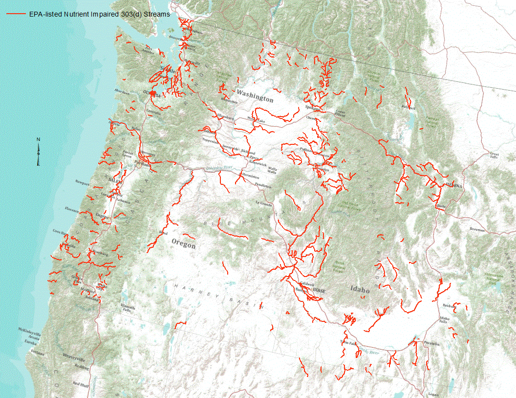
“Under section 303(d) of the 1972 Clean Water Act, states, territories, and authorized tribes are required to develop lists of impaired waters. These impaired waters do not meet water quality standards that states, territories, and authorized tribes have set for them, even after point sources of pollution have installed the minimum required levels of pollution control technology. The law requires that these jurisdictions establish priority rankings for waters on the lists and develop TMDLs for these waters” (U.S. Environmental Protection Agency, 2011). Waterways represented in this data set are a subset of these EPA 303 (d) listed streams that were classified as nutrient impaired. Nutrient impaired streams include...
A boosted regression tree (BRT) model was developed to predict pH conditions in three-dimensions throughout the glacial aquifer system (GLAC) of the contiguous United States using pH measurements in samples from 18,258 wells and predictor variables that represent aspects of the hydrogeologic setting. Model results indicate that the carbonate content of soils and aquifer materials strongly controls pH and when coupled with long flow paths, results in the most alkaline conditions. Conversely, in areas where glacial sediments are thin and carbonate-poor, pH conditions remain acidic. At depths typical of drinking-water supplies, predicted pH > 7.5 – which is associated with arsenic mobilization – occurs more frequently...
Categories: Data;
Types: Map Service,
OGC WFS Layer,
OGC WMS Layer,
OGC WMS Service;
Tags: Boosted regression trees,
Calcite saturation index,
Connecticut,
Geochemistry,
Geochemistry,
These data were released prior to the October 1, 2016 effective date for the USGS’s policy dictating the review, approval, and release of scientific data as referenced in USGS Survey Manual Chapter 502.8 Fundamental Science Practices: Review and Approval of Scientific Data for Release. This map shows specific water-quality items and hydrologic data site information which come from QWDATA (Water Quality) and GWSI (Ground Water Information System). Both QWDATA and GWSI are subsystems of NWIS (National Water Inventory System)of the USGS (United States Geologic Survey). This map is for Wayne County, Utah. The scope and purpose of NWIS is defined on the web site: http://water.usgs.gov/public/pubs/FS/FS-027-98/
These data were collected as part of the Great Lakes Restoration Initiative (GLRI) project template 678-1 entitled "Evaluate immediate and long-term BMP effectiveness of GLRI restoration efforts at urban beaches on Southern and Western Lake Michigan". This project is evaluating the effectiveness of projects that are closely associated with restoration of local habitat and contact recreational activities at two GLRI funded sites in Southern Lake Michigan and one non-GLRI site in Western Lake Michigan. Evaluation of GLRI projects will assess whether goals of recipients are on track and identify any developing unforeseen consequences. Including a third, non-GLRI project site in the evaluation allows comparison between...

These data were released prior to the October 1, 2016 effective date for the USGS’s policy dictating the review, approval, and release of scientific data as referenced in USGS Survey Manual Chapter 502.8 Fundamental Science Practices: Review and Approval of Scientific Data for Release. Under section 303(d) of the 1972 Clean Water Act, states, territories, and authorized tribes are required to develop lists of impaired waters. These impaired waters do not meet water quality standards that states, territories, and authorized tribes have set for them, even after point sources of pollution have installed the minimum required levels of pollution control technology. The law requires that these jurisdictions establish...
These data were released prior to the October 1, 2016 effective date for the USGS’s policy dictating the review, approval, and release of scientific data as referenced in USGS Survey Manual Chapter 502.8 Fundamental Science Practices: Review and Approval of Scientific Data for Release. This map shows specific water-quality items and hydrologic data site information which come from QWDATA (Water Quality) and GWSI (Ground Water Information System). Both QWDATA and GWSI are subsystems of NWIS (National Water Inventory System)of the USGS (United States Geologic Survey). This map is for Boxelder County, Utah. The scope and purpose of NWIS is defined on the web site: http://water.usgs.gov/public/pubs/FS/FS-027-98/
These data were collected as part of the Great Lakes Restoration Initiative (GLRI) project template 678-1 entitled "Evaluate immediate and long-term BMP effectiveness of GLRI restoration efforts at urban beaches on Southern and Western Lake Michigan". This project is evaluating the effectiveness of projects that are closely associated with restoration of local habitat and contact recreational activities at two GLRI funded sites in Southern Lake Michigan and one non-GLRI site in Western Lake Michigan. Evaluation of GLRI projects will assess whether goals of recipients are on track and identify any developing unforeseen consequences. Including a third, non-GLRI project site in the evaluation allows comparison between...
This U.S. Geological Survey (USGS) Data Release provides discrete water-quality data collected from four sites on the Kansas River and four of its tributaries during July 2012 through September 2016. The water-quality constituents included in this data release are the cyanotoxins microcystin and cylindrospermopsin, the taste-and-odor compounds geosmin and 2-methylisoborneol, major ions, alkalinity, nutrients, suspended sediment, indicator bacteria, and actinomycetes bacteria.
Categories: Data;
Types: Citation;
Tags: 2-methylisoborneol,
Actinomycetes bacteria,
Alkalinity,
Big Blue River nr Manhattan, KS,
Chlorophyll,
The Bushy Park Reservoir is a relatively shallow impoundment in a semi-tropical climate and is the principal water supply for the 400,000 people of the City of Charleston and the surrounding areas including the industries in the Bushy Park Industrial Complex. Although there is an adequate supply of freshwater in the reservoir, there are taste-and-odor water-quality concerns. The U.S. Geological Survey (USGS) worked in cooperation with the Charleston Water System to study the hydrology and water-quality of the Bushy Park Reservoir to identify factors affecting water-quality conditions. This data release is for the water-quality data collected with an autonomous underwater vehicle (AUV) for a water-quality study of...
These data were released prior to the October 1, 2016 effective date for the USGS’s policy dictating the review, approval, and release of scientific data as referenced in USGS Survey Manual Chapter 502.8 Fundamental Science Practices: Review and Approval of Scientific Data for Release. This map shows specific water-quality items and hydrologic data site information which come from QWDATA (Water Quality) and GWSI (Ground Water Information System). Both QWDATA and GWSI are subsystems of NWIS (National Water Inventory System)of the USGS (United States Geologic Survey). This map is for Garfield County, Utah. The scope and purpose of NWIS is defined on the web site: http://water.usgs.gov/public/pubs/FS/FS-027-98/
These data were released prior to the October 1, 2016 effective date for the USGS’s policy dictating the review, approval, and release of scientific data as referenced in USGS Survey Manual Chapter 502.8 Fundamental Science Practices: Review and Approval of Scientific Data for Release. This map shows specific water-quality items and hydrologic data site information which come from QWDATA (Water Quality) and GWSI (Ground Water Information System). Both QWDATA and GWSI are subsystems of NWIS (National Water Inventory System)of the USGS (United States Geologic Survey). This map is for Cache County, Utah. The scope and purpose of NWIS is defined on the web site: http://water.usgs.gov/public/pubs/FS/FS-027-98/
These data were released prior to the October 1, 2016 effective date for the USGS’s policy dictating the review, approval, and release of scientific data as referenced in USGS Survey Manual Chapter 502.8 Fundamental Science Practices: Review and Approval of Scientific Data for Release. This map shows specific water-quality items and hydrologic data site information which come from QWDATA (Water Quality) and GWSI (Ground Water Information System). Both QWDATA and GWSI are subsystems of NWIS (National Water Inventory System)of the USGS (United States Geologic Survey). This map is for Iron County, Utah. The scope and purpose of NWIS is defined on the web site: http://water.usgs.gov/public/pubs/FS/FS-027-98/
These data were released prior to the October 1, 2016 effective date for the USGS’s policy dictating the review, approval, and release of scientific data as referenced in USGS Survey Manual Chapter 502.8 Fundamental Science Practices: Review and Approval of Scientific Data for Release. This map shows specific water-quality items and hydrologic data site information which come from QWDATA (Water Quality) and GWSI (Ground Water Information System). Both QWDATA and GWSI are subsystems of NWIS (National Water Inventory System)of the USGS (United States Geologic Survey). This map is for Sanpete County, Utah. The scope and purpose of NWIS is defined on the web site: http://water.usgs.gov/public/pubs/FS/FS-027-98/
|

|
