Filters: Tags: point cloud (X)
33 results (1.5s)|
Filters
Contacts
(Less)
|
These data are high-resolution bathymetry (riverbed elevation) in compressed LAS (*.laz) format, generated from the July 17–19, 2023, hydrographic survey of Bubbly Creek and various sidings, harbors, and turning basins on the Chicago Sanitary and Ship Canal (CS&SC) in Cook County, Illinois. The survey includes all Bubbly Creek from the confluence with the CS&SC in the north to the Racine Avenue Pump station in the south; various sidings and turning basins along the CS&SC between Kedzie Avenue and South Halsted Street; and the Marine Safety Station harbor near the Chicago Harbor Lock on Lake Michigan. This survey is a continuation and enhancement of the bathymetric survey of the CS&SC in Cook County, Illinois, conducted...
The U.S. Geological Survey, in cooperation with Colorado Springs Utilities, has been collecting topographic data annually since 2012 at 10 study areas along Fountain Creek, Colorado. The 10 study areas are located along Fountain Creek between Colorado Springs and the confluence of Fountain Creek and the Arkansas River in Pueblo. This data release presents topographic survey data, Light Detection and Ranging (lidar) survey data, and elevation rasters collected or generated during 2020 as part of that monitoring effort. Topographic survey points were collected using real-time kinematic Global Navigation Satellite Systems (RTK-GNSS). These point data, along with lidar point clouds, were used to generate 2020 digital...
Categories: Data;
Types: Map Service,
OGC WFS Layer,
OGC WMS Layer,
OGC WMS Service;
Tags: Colorado,
Colorado Springs,
El Paso County,
Fountain,
Fountain Creek,
In support of U.S. Geological Survey (USGS) Southwest Biological Science Center researchers, and in coordination with the Bureau of Land Management (BLM) and National Ecological Observatory Network (NEON), the USGS National Uncrewed Systems Office (NUSO) conducted uncrewed aircraft systems (UAS) remote sensing flights over two BLM Assessment, Inventory, and Monitoring (AIM) plots at the NEON Moab site in Utah for multi-scale carbon sequestration research on public lands. The UAS data collected include natural color, multispectral, and hyperspectral imagery, and lidar to capture diverse information about vegetation and soils on drylands. The first site (“site 1”) features intact sagebrush and was mapped on May 3,...
In support of U.S. Geological Survey (USGS) Southwest Biological Science Center researchers, and in coordination with the Bureau of Land Management (BLM) and National Ecological Observatory Network (NEON), the USGS National Uncrewed Systems Office (NUSO) conducted uncrewed aircraft systems (UAS) remote sensing flights over two BLM Assessment, Inventory, and Monitoring (AIM) plots at the NEON Moab site in Utah for multi-scale carbon sequestration research on public lands.The UAS data collected include natural color, multispectral, and hyperspectral imagery, and lidar to capture diverse information about vegetation and soils on two dryland sites approximately 40 km south of Moab, Utah. The first site (“site 1”) features...
Categories: Data;
Types: Map Service,
OGC WFS Layer,
OGC WMS Layer,
OGC WMS Service;
Tags: Remote Sensing,
San Juan County,
UAS,
USGS Science Data Catalog (SDC),
Utah,
These data are high-resolution bathymetry (riverbed elevation) in compressed LAS (*.laz) format, generated from the August 22–24, 2022, hydrographic survey of the Chicago Sanitary and Ship Canal (CS&SC) and sections of the Chicago River and North Branch Chicago River in Cook County, Illinois. The survey extends from the Cook County line near Interstate 355 in the southwest upstream to the Chicago Harbor Lock on the Chicago River in the northeast, and northward on the North Branch Chicago River to the North Avenue Turning Basin in the north. Hydrographic data were collected using a high-resolution multibeam echosounder mapping system (MBMS), which consists of a multibeam echosounder (MBES) and an inertial navigation...
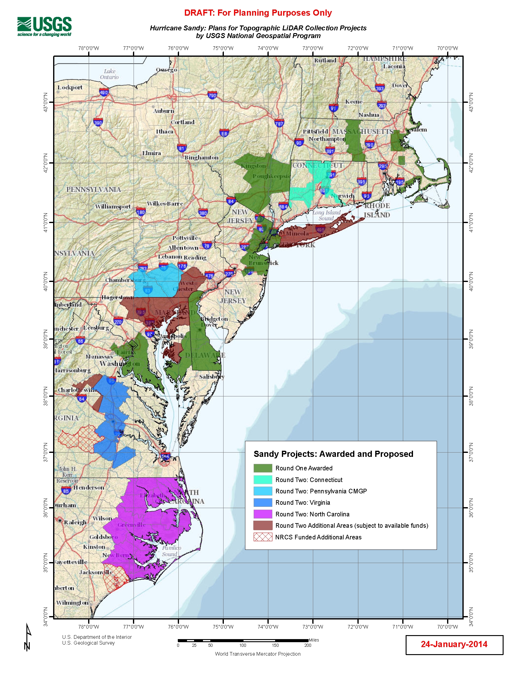
U.S. Geological Survey, Department of the Interior - The Hurricane Sandy Supplemental Funding lidar and DEM acquisition plan is part of the 3DEP initiative to systematically collect enhanced elevation data (Quality Level 2) in the form of high-quality light detection and ranging (lidar) data over the conterminous United States, Hawaii, and the territories on an 8-year schedule. The FY14 Hurricane Sandy acquisition plan currently anticipates collecting 20,000 - 30,000 sq. mi. within the impacted area. Exact area collected will depend on partnerships and other contributions to the plan. Interested parties who wish to become a funding partner with the USGS FY14 or in future years should contact a USGS Geospatial Liaison...
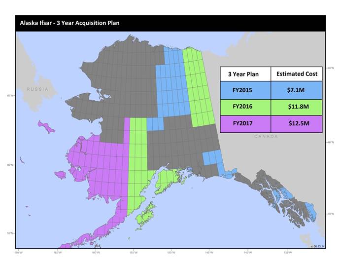
U.S. Geological Survey, Department of the Interior - The annual Alaska IfSAR and DEM acquisition plan is part of the 3DEP initiative to collect high-quality elevation data in the form of interferometric synthetic aperture radar (IfSAR) and light detection and ranging (lidar) data over Alaska. This acquisition plan addresses concerns raised in GAO Report 13-94 regarding geospatial coordination, and supports FGDC data coordination initiatives led by the Department of Interior's Geospatial Information Officer. Mapping a State the size and complexity of Alaska through a partnered effort such as the Alaska Mapping Initiative requires dedicated collaboration and coordination across multiple levels of government. State...
U.S. Geological Survey, Department of the Interior - The annual lidar and DEM acquisition plan is part of the 3DEP initiative to systematically collect enhanced elevation data (Quality Level 2) in the form of high-quality light detection and ranging (lidar) data over the conterminous United States, Hawaii, and the territories on an 8-year schedule. The FY17 acquisition plan currently anticipates collecting 225,000 sq. mi. or more depending on partnerships and other contributions to the plan. Interested parties who wish to become a funding partner with the USGS in FY17 or in future years should contact a USGS Geospatial Liaison - http://liaisons.usgs.gov/geospatial/documents/TNM_Partnership_User_ContactList.pdf....
In 2012, the U.S. Geological Survey (USGS) in cooperation with Colorado Springs Utilities selected 10 study areas along Fountain Creek between Colorado Springs, Colorado and the confluence of Fountain Creek with the Arkansas River for annual geomorphic monitoring. The purpose of this data release is to present topographic survey data, rasters , and sediment size data collected in 2019 as part of that monitoring effort. Topographic survey points were collected using real-time kinematic Global Navigation Satellite Systems (RTK-GNSS). These point data were interpolated to generate digital elevation maps (2015 and 2019) and elevation-change maps (from 2015 to 2019) at each study area . In 2019, two types of Unmanned...
The USGS, in cooperation with the U.S. Bureau of Land Management (BLM), created a series of geospatial products using historic aerial imagery and SfM photogrammetry methods. A point cloud dataset (.laz) of the South Cow Mountain Recreational Area was generated from stereo historical aerial imagery acquired in by the BLM in May of 1977. The aerial imagery were downloaded from the USGS Earth Resources Observation and Science (EROS) Data Center's USGS Single Aerial Frame Photo archive and a was created using USGS guidelines. Photo alignment, error reduction, and dense point cloud generation followed guidelines documented in Over, J.R., Ritchie, A.C., Kranenburg, C.J., Brown, J.A., Buscombe, D., Noble, T., Sherwood,...
These data are high-resolution bathymetry (riverbed elevation) and depth-averaged velocities in comma-delimited table format, generated from hydrographic and velocimetric surveys near highway bridge structures over the Missouri River between Kansas City and St. Louis, Missouri, May 19–26, 2021. Hydrographic data were collected using a high-resolution multibeam echosounder mapping system (MBMS), which consists of a multibeam echosounder (MBES) and an inertial navigation system (INS) mounted on a marine survey vessel. Data were collected as the vessel traversed the river along planned survey lines distributed throughout the reach. Data collection software integrated and stored the depth data from the MBES and the...
This data release consists of three child items distinguishing the following types of data: light detection and ranging (lidar) point clouds (LPCs), digital elevation models (DEMs), and snow depth raster maps. These three data types are all derived from lidar data collected on small, uncrewed aircraft systems (sUAS) at study areas in the Upper Colorado River Basin, Colorado, from 2020 to 2022. These data were collected and generated as part of the U.S. Geological Survey's (USGS) Next Generation Water Observing Systems (NGWOS) Upper Colorado River Basin project.
In support of U.S. Geological Survey (USGS) Southwest Biological Science Center researchers, and in coordination with the Bureau of Land Management (BLM) and National Ecological Observatory Network (NEON), the USGS National Uncrewed Systems Office (NUSO) conducted uncrewed aircraft systems (UAS) remote sensing flights over two BLM Assessment, Inventory, and Monitoring (AIM) plots at the NEON Moab site in Utah for multi-scale carbon sequestration research on public lands. The UAS data collected include natural color, multispectral, and hyperspectral imagery, and lidar to capture diverse information about vegetation and soils on drylands. The first site (“site 1”) features intact sagebrush and was mapped on May 3,...
Structure-from-Motion (SfM) point clouds were created from images collected using a remotely piloted unoccupied aerial system (UAS) over the bluffs of the eastern shore of Lake Michigan in Ludington, MI, a rural natural area to assess land changes. The digital imagery was collected with the internal camera of a DJI Phantom 3 PRO for the July 11, 2019, data and DJI Phantom 4 PRO for the July 14, 2021, data that was operated by the University of Toledo. The images cover an extent between north of Chauvez Rd. to the south and north of W. Bradshaw Rd. to the north. The images were collected in .jpg format and include default Exif metadata with GPS date, time, latitude and longitude, and other fields. Point clouds were...
As one of the cornerstones of the U.S. Geological Survey's (USGS) National Geospatial Program, The National Map is a collaborative effort among the USGS and other Federal, State, and local partners to improve and deliver topographic information for the Nation. It has many uses ranging from recreation to scientific analysis to emergency response. The National Map is easily accessible for display on the Web, as products and services, and as downloadable data. The geographic information available from The National Map includes orthoimagery (aerial photographs), elevation, geographic names, hydrography, boundaries, transportation, structures, and land cover.
These data are high-resolution bathymetry (riverbed elevation) in compressed LAS (*.laz) format, generated from the August 1–3, 2022, hydrographic survey of the Calumet River and Calumet Sag Channel in Cook County, Illinois. The survey extends from the junction with Lake Michigan in the northeast downstream to the junction with the Chicago Sanitary and Ship Canal in the southwest. Hydrographic data were collected using a high-resolution multibeam echosounder mapping system (MBMS), which consists of a multibeam echosounder (MBES) and an inertial navigation system (INS) mounted on a marine survey vessel. Data were collected as the vessel traversed the channel along overlapping longitudinal survey lines distributed...
Six elevation point cloud files in LAZ format (compressed LAS binary data) are included in this data release: 3 raw point clouds of unclassified and unedited points and 3 modified point clouds that were spatially shifted and edited to remove outliers and spurious elevation values associated with moving water surfaces. An XYZ coordinate shift was applied to each data set in order to register the data sets to an earth-based datum established from surveyed ground control points. Points are unclassified and ground-reflected color values in the red-green-blue (RGB) schema are included. The horizontal coordinate system is WGS84, UTM Zone 7 North meters; vertical coordinates are relative to the WGS84 ellipsoid. Aerial...
Imagery acquired with unmanned aerial systems (UAS) and coupled with structure-from-motion (SfM) photogrammetry can produce high-resolution topographic and visual reflectance datasets that rival or exceed lidar and orthoimagery. These new techniques are particularly useful for data collection of coastal systems, which requires high temporal and spatial resolution datasets. The U.S. Geological Survey worked in collaboration with members of the Marine Biological Laboratory and Woods Hole Analytics at Black Beach, in Falmouth, Massachusetts to explore scientific research demands on UAS technology for topographic and habitat mapping applications. This project explored the application of consumer-grade UAS platforms...
U.S. Geological Survey, Department of the Interior - The annual Alaska IfSAR and DEM acquisition plan is part of the 3DEP initiative to collect high-quality elevation data in the form of interferometric synthetic aperture radar (IfSAR) and light detection and ranging (lidar) data over Alaska. This acquisition plan addresses concerns raised in GAO Report 13-94 regarding geospatial coordination, and supports FGDC data coordination initiatives led by the Department of Interior's Geospatial Information Officer. Mapping a State the size and complexity of Alaska through a partnered effort such as the Alaska Mapping Initiative requires dedicated collaboration and coordination across multiple levels of government. State...
The U.S. Geological Survey, in cooperation with Colorado Springs Utilities, has been collecting topographic data annually since 2012 at 10 study areas along Fountain Creek, Colorado. The 10 study areas are located along Fountain Creek between Colorado Springs and the confluence of Fountain Creek and the Arkansas River in Pueblo. This data release presents topographic survey data, Light Detection and Ranging (lidar) survey data, elevation rasters, and elevation-change rasters collected or generated in 2021 as part of that monitoring effort. Topographic survey points were collected using real-time kinematic Global Navigation Satellite Systems (RTK-GNSS). These point data, along with lidar point clouds, were used to...
Categories: Data;
Types: Map Service,
OGC WFS Layer,
OGC WMS Layer,
OGC WMS Service;
Tags: Colorado,
Colorado Springs,
El Paso County,
Fountain,
Fountain Creek,
|

|
