Filters: Tags: scenario (X)
317 results (12ms)|
Filters
Date Range
Extensions Types
Contacts
Categories Tag Types
|
The Vista tool is used to create a Scenario of the water use CAs affecting the North American Warm Desert Riparian Woodland, Shrubland, Mesquite Bosque and Stream CE and applies user-input Landscape Condition Model (LCM) scores to generate ESAs for the CE. The LCM consists of Site Impact scores and impact Distances for each CA category. Site Impact scores are a value between 0 and 1 representing the impact of the CA on the relevant CEs. A score close to 1 indicates negligible or no impact from that CA. A score close to 0 indicates the highest possible impact, e.g. an interstate highway that makes the area in which it occurs completely unsuitable for the CE. Distances are set in meters and extend the impact of the...
The Vista tool is used to create a Scenario of the CAs affecting the North American Warm Desert Riparian Woodland, Shrubland, Mesquite Bosque and Stream CE and applies user-input Landscape Condition Model (LCM) scores to generate ESAs for each of the CEs. The LCM consists of Site Impact scores and impact Distances for each CA category. Site Impact scores are a value between 0 and 1 representing the impact of the CA on the relevant CEs. A score close to 1 indicates negligible or no impact from that CA. A score close to 0 indicates the highest possible impact, e.g. an interstate highway that makes the area in which it occurs completely unsuitable for the CE. Distances are set in meters and extend the impact of the...
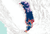
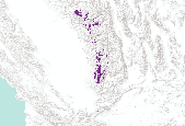
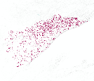
The Vista tool is used to create a Scenario of CAs affecting the Terrestrial Montane Lifezone Distribution CE and applies user-input Landscape Condition Model (LCM) scores to generate an Ecological Integrity Assessment (EIA) for the CE. The LCM consists of Site Impact scores and impact Distances for each CA category. Site Impact scores are a value between 0 and 1 representing the impact of the CA on the relevant CEs. A score close to 1 indicates negligible or no impact from that CA. A score close to 0 indicates the highest possible impact, e.g. an interstate highway that makes the area in which it occurs completely unsuitable for the CE. Distances are set in meters and extend the impact of the CA from the footprint...
The Vista tool is used to create a Scenario of the development CAs affecting the Coues White-tail Deer (Odocoilus virginianus couesi) CE and applies user-input Landscape Condition Model (LCM) scores to generate ESAs for each of the CEs. The LCM consists of Site Impact scores and impact Distances for each CA category. Site Impact scores are a value between 0 and 1 representing the impact of the CA on the relevant CEs. A score close to 1 indicates negligible or no impact from that CA. A score close to 0 indicates the highest possible impact, e.g. an interstate highway that makes the area in which it occurs completely unsuitable for the CE. Distances are set in meters and extend the impact of the CA from the footprint...
The Vista tool is used to create a Scenario of the invasives CAs affecting the Pronghorn (Antilocapra americana) CE and applies user-input Landscape Condition Model (LCM) scores to generate ESAs for each of the CEs. The LCM consists of Site Impact scores and impact Distances for each CA category. Site Impact scores are a value between 0 and 1 representing the impact of the CA on the relevant CEs. A score close to 1 indicates negligible or no impact from that CA. A score close to 0 indicates the highest possible impact, e.g. an interstate highway that makes the area in which it occurs completely unsuitable for the CE. Distances are set in meters and extend the impact of the CA from the footprint out for the specified...
The Vista tool is used to create a Scenario of the invasives CAs affecting the Mogollon Chaparral CE and applies user-input Landscape Condition Model (LCM) scores to generate ESAs for each of the CEs. The LCM consists of Site Impact scores and impact Distances for each CA category. Site Impact scores are a value between 0 and 1 representing the impact of the CA on the relevant CEs. A score close to 1 indicates negligible or no impact from that CA. A score close to 0 indicates the highest possible impact, e.g. an interstate highway that makes the area in which it occurs completely unsuitable for the CE. Distances are set in meters and extend the impact of the CA from the footprint out for the specified distance,...
The GeoAdaptive and GeoDesign scenarios were extended to the state of Florida line and incorporated CLIP 3.0 into the scenarios for the ecological input. The scenarios will consist of urbanization level of 31,000,000 people by 2060 and sea level rise of 1.0m, and policies and assumptions such a build first conserve second (BAU) and conserve first build second (proactive). The type of conservation was varied; fee simple purchase and easement percentages. The first scenario had a 50/50 split between fee simple purchase and easements and the second and third scenario had 90% easement and 10% fee simple purchase. The difference in scenario was in the process of conservation (CLIP priority area 1 or Florida Forever land...
Categories: Data,
Project;
Types: Map Service,
OGC WFS Layer,
OGC WMS Layer,
OGC WMS Service;
Tags: Conservation Planning,
Florida climate change,
LCC,
LCC Network Science Catalog,
Other,
Policy-relevant flood risk modeling must capture interactions between physical and social processes to accurately project impacts from scenarios of sea level rise and inland flooding due to climate change. Here we simultaneously model urban growth, flood hazard change, and adaptive response using the FUTure Urban-Regional Environment Simulation (FUTURES) version 3 framework (Sanchez et al., 2023). FUTURES is an open source urban growth model designed to address the regional-scale ecological and environmental impacts of urbanization; it is one of the few land change models that explicitly captures the spatial structure of development in response to user-specified scenarios. We present probabilistic land change projections...
The USGS Forecasting Scenarios of Land-use Change (FORE-SCE) model was used to produce an agricultural biofuel scenarios for the Northern Glaciated Plains, from 2012 to 2030. The modeling used parcel data from the USDA's Common Land Unit (CLU) data set to represent real, contiguous ownership and land management units. A Monte Carlo approach was used to create 50 unique replicates of potential landscape conditions in the future, based on a agricultural scenario from the U.S. Department of Energy's Billion Ton Update. The data are spatially explicit, covering the entire Northern Glaciated Plains ecoregions (an EPA Level III ecoregion), with a spatial resolution of 30-meters and 22 unique land-cover classes (including...
Types: Citation,
Map Service,
OGC WFS Layer,
OGC WMS Layer,
OGC WMS Service;
Tags: FORE-SCE,
Great Plains,
Land Cover,
Minnesota,
Model,

Standard Deviation of Annual Temperature (2045-2060) from HadCM3 GCM under A2 scenario (Western USA)
Ken Ferschweiler (CBI) used climate data from the PRISM group (Chris Daly, Oregon State University) at 4kmx4km spatial grain across the conterminous USA to generate a climatology or baseline. He then created future climate change scenarios using statistical downscaling and created anomalies from the Hadley CM3 General Circulation Model (GCM) run through the A2 emission scenario (SRES - special report on emission scenarios published in 2000). To run the MAPSS model (Neilson 1995), average monthly temperatures were calculated for the period 2045-2060. This dataset shows the standard deviation of the annual mean temperature for that period.

This dataset represents presence of Black Spruce (Picea mariana) at year 100 (2095) from a single model run of LANDIS-II. The simulation assumed Intergovernmental Panel on Climate Change (IPCC) B2 emissions (moderate) and used the Hadley 3 global circulation model. Contemporary harvest rates and intensities were simulated.
The Nature Conservancy (TNC) has derived climate suitability forecasts for most species of trees and shrubs considered to be ecological dominants of terrestrial Californian habitat types. Our plant projections are compiled as decision support tools to help Conservancy project staff, as well as our external partners, develop the necessary plans, priorities and strategies to successfully adapt to uncertain changes in future climate. In the recently completed Southern Sierra Partnership's 2010 Climate-Adapted Conservation Plan for the Southern Sierra Nevada and Tehachapi Mountains, species and habitat forecasts shown here informed the development of a regional conservation design that explicitly incorporates long-term...

The Nature Conservancy (TNC) has derived climate suitability forecasts for most species of trees and shrubs considered to be ecological dominants of terrestrial Californian habitat types. Our plant projections are compiled as decision support tools to help Conservancy project staff, as well as our external partners, develop the necessary plans, priorities and strategies to successfully adapt to uncertain changes in future climate. In the recently completed Southern Sierra Partnership's 2010 Climate-Adapted Conservation Plan for the Southern Sierra Nevada and Tehachapi Mountains, species and habitat forecasts shown here informed the development of a regional conservation design that explicitly incorporates long-term...

The Nature Conservancy (TNC) has derived climate suitability forecasts for most species of trees and shrubs considered to be ecological dominants of terrestrial Californian habitat types. Our plant projections are compiled as decision support tools to help Conservancy project staff, as well as our external partners, develop the necessary plans, priorities and strategies to successfully adapt to uncertain changes in future climate. In the recently completed Southern Sierra Partnership's 2010 Climate-Adapted Conservation Plan for the Southern Sierra Nevada and Tehachapi Mountains, species and habitat forecasts shown here informed the development of a regional conservation design that explicitly incorporates long-term...

The Nature Conservancy (TNC) has derived climate suitability forecasts for most species of trees and shrubs considered to be ecological dominants of terrestrial Californian habitat types. Our plant projections are compiled as decision support tools to help Conservancy project staff, as well as our external partners, develop the necessary plans, priorities and strategies to successfully adapt to uncertain changes in future climate. In the recently completed Southern Sierra Partnership's 2010 Climate-Adapted Conservation Plan for the Southern Sierra Nevada and Tehachapi Mountains, species and habitat forecasts shown here informed the development of a regional conservation design that explicitly incorporates long-term...

The Nature Conservancy (TNC) has derived climate suitability forecasts for most species of trees and shrubs considered to be ecological dominants of terrestrial Californian habitat types. Our plant projections are compiled as decision support tools to help Conservancy project staff, as well as our external partners, develop the necessary plans, priorities and strategies to successfully adapt to uncertain changes in future climate. In the recently completed Southern Sierra Partnership's 2010 Climate-Adapted Conservation Plan for the Southern Sierra Nevada and Tehachapi Mountains, species and habitat forecasts shown here informed the development of a regional conservation design that explicitly incorporates long-term...

The Nature Conservancy (TNC) has derived climate suitability forecasts for most species of trees and shrubs considered to be ecological dominants of terrestrial Californian habitat types. Our plant projections are compiled as decision support tools to help Conservancy project staff, as well as our external partners, develop the necessary plans, priorities and strategies to successfully adapt to uncertain changes in future climate. In the recently completed Southern Sierra Partnership's 2010 Climate-Adapted Conservation Plan for the Southern Sierra Nevada and Tehachapi Mountains, species and habitat forecasts shown here informed the development of a regional conservation design that explicitly incorporates long-term...
The Nature Conservancy (TNC) has derived climate suitability forecasts for most species of trees and shrubs considered to be ecological dominants of terrestrial Californian habitat types. Our plant projections are compiled as decision support tools to help Conservancy project staff, as well as our external partners, develop the necessary plans, priorities and strategies to successfully adapt to uncertain changes in future climate. In the recently completed Southern Sierra Partnership's 2010 Climate-Adapted Conservation Plan for the Southern Sierra Nevada and Tehachapi Mountains, species and habitat forecasts shown here informed the development of a regional conservation design that explicitly incorporates long-term...

The Nature Conservancy (TNC) has derived climate suitability forecasts for most species of trees and shrubs considered to be ecological dominants of terrestrial Californian habitat types. Our plant projections are compiled as decision support tools to help Conservancy project staff, as well as our external partners, develop the necessary plans, priorities and strategies to successfully adapt to uncertain changes in future climate. In the recently completed Southern Sierra Partnership's 2010 Climate-Adapted Conservation Plan for the Southern Sierra Nevada and Tehachapi Mountains, species and habitat forecasts shown here informed the development of a regional conservation design that explicitly incorporates long-term...
This dataset represents presence of Red Pine (Pinus resinosa) at year 50 (2045) in Minnesota (USA) from a single model run of LANDIS-II. The simulation assumed Intergovernmental Panel on Climate Change (IPCC) B2 emissions (moderate) and used the Hadley 3 global circulation model. Contemporary harvest rates and intensities were simulated.
|

|
