Filters: Tags: shale (X)
17,502 results (12ms)|
Filters
Contacts
(Less)
|
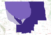
These data depict the Mean Estimate of Volume of Natural Gas Liquids in Gas Accumulations (non-associated gas) in Oil Accumulations in the Bakken Formation, Williston Basin Province. Measured in billions of cubic feet (BCFG) This dataset was compiled from Assessment of Undiscovered Oil Resources in the Devonian-Mississippian Bakken Formation, Williston Province, Montana and North Dakota, 2008. A single Attribute has been chosen for display: NAGASMEAN. Volume of gas below 20 units have been excluded.
Petroleum within unconventional source-rock reservoirs is hosted in organic matter and mineral pore space as well as in voids and microfractures. Recent work has shown that for source-rock reservoirs in the dry gas window, significant portions of methane (CH4), the main component of petroleum at elevated maturities, can be stored within fine organic matter porosity. However, within reservoirs at lower thermal maturities (e.g., peak oil or wet-gas conditions), the distribution and behavior of CH4 and the higher alkanes that comprise gas condensates across pore sizes is unclear, especially for fine pores with diameters <50 nm. Understanding CH4 within these settings provides insight for petroleum generation, movement,...
Categories: Data;
Tags: Colorado,
Contrast Matching,
Denver-Julesburg Basin,
Energy Resources,
Gas Condensate,
The Appalachians are a landscape filled with globally-significant biological diversity and cultural resources that provides essential benefits to large cities and surrounding human communities. The region is also rich in energy resources that meet national and regional demands for energy. As wind, natural gas, and oil energy development expand along with traditional coal, there is an increasing need for research to inform discussions on how to meet immediate and future energy needs while sustaining the health of natural systems. To help address this need, the Appalachian LCC awarded a grant to The Nature Conservancy to assess current and future energy development across the entire region. Assessing Future Energy...
Categories: Data;
Tags: Academics & scientific researchers,
AppLCC,
Appalachian,
Conservation NGOs,
Data,
Core Research Center, core T351, from well operated by PINE RIDGE OILRaw Properties from download, web scrape, MapServer, and Macrostrat API{"Lib Num": "T351", "API Num": "0507306494", "Operator": "PINE RIDGE OIL", "Well Name": "BUSY GULLY 13-54-12-3A", "Field": "LONG SHADOW", "State": "CO", "County": "LINCOLN", "Type": "SLABBED", "Photos": "T", "Thin Sec": "F", "Analysis": "F", "Latitude": "38.933503", "Longitude": "-103.399758", "coordinates_geohash": "9wymrpds54br", "Source": "PROVIDED BY DONOR", "Security Flag": "NO SPECIAL RESTRICTIONS", "crc_collection_name": "core", "sb_parent_id": "4f4e49dae4b07f02db5e0486", "intervals": [{"Formation": "MARMATON / CHEROKEE UPPER", "Age": "PENNSYLVANIAN", "Min Depth": "5967",...
Categories: Physical Item;
Tags: CHEROKEE,
Late Cretaceous,
MARMATON / CHEROKEE UPPER,
PENNSYLVANIAN,
PENNSYLVANIAN,
Core Research Center, core A496, from well operated by TEXAS GAS EXPLRaw Properties from download, web scrape, MapServer, and Macrostrat API{"Lib Num": "A496", "API Num": "4900920735", "Operator": "TEXAS GAS EXPL", "Well Name": "2 L PIERSON", "Field": "WELL DRAW", "State": "WY", "County": "CONVERSE", "Type": "SLABBED", "Photos": "T", "Thin Sec": "F", "Analysis": "F", "Latitude": "42.91921", "Longitude": "-105.09938", "coordinates_geohash": "9xtk0mhywbwh", "Source": "FROM STATE RECORDS", "Security Flag": "NO SPECIAL RESTRICTIONS", "crc_collection_name": "core", "sb_parent_id": "4f4e49dae4b07f02db5e0486", "intervals": [{"Formation": "TECKLA", "Age": "CRET", "Min Depth": "6907", "Max Depth": "6937"}, {"Formation":...
Core Research Center, core U223, from well operated by PACIFIC ENERGY & MINRaw Properties from download, web scrape, MapServer, and Macrostrat API{"Lib Num": "U223", "API Num": null, "Operator": "PACIFIC ENERGY & MIN", "Well Name": "2 HORSE PRAIRIE D D", "Field": "TERTIARY BASIN PROJ", "State": "MT", "County": "BEAVERHEAD", "Type": "FULL", "Photos": "F", "Thin Sec": "F", "Analysis": "F", "Latitude": "44.941452", "Longitude": "-113.026695", "coordinates_geohash": "9rzxsj26zjge", "Source": "CENTER OF QUARTER SECTION", "Security Flag": "NO SPECIAL RESTRICTIONS", "crc_collection_name": "core", "sb_parent_id": "4f4e49dae4b07f02db5e0486", "intervals": [{"Formation": "OLIGOCENE", "Age": "QUAT", "Min Depth": "0", "Max Depth":...
Categories: Physical Item;
Tags: Bozeman Group,
Bozeman Group and related valley-fill deposits, undivided,
OLIGOCENE,
QUAT,
Tertiary,
Core Research Center, core T297, from well operated by MARATHON RESOURCESRaw Properties from download, web scrape, MapServer, and Macrostrat API{"Lib Num": "T297", "API Num": null, "Operator": "MARATHON RESOURCES", "Well Name": "56B MCDOWELL RANCH", "Field": null, "State": "MT", "County": "CARTER", "Type": "FULL", "Photos": "F", "Thin Sec": "F", "Analysis": "F", "Latitude": "45.106436", "Longitude": "-104.470188", "coordinates_geohash": "c8j8werhh1jg", "Source": "CENTER OF SECTION", "Security Flag": "NO SPECIAL RESTRICTIONS", "crc_collection_name": "core", "sb_parent_id": "4f4e49dae4b07f02db5e0486", "intervals": [{"Formation": "DAKOTA", "Age": "CRET", "Min Depth": "1230", "Max Depth": "1380"}], "crcwc_url": "https://my.usgs.gov/crcwc/core/report/14084",...
Core Research Center, core S497, from well operated by WYOIL CORP.Raw Properties from download, web scrape, MapServer, and Macrostrat API{"Lib Num": "S497", "API Num": "4900320827", "Operator": "WYOIL CORP.", "Well Name": "SAGEBUSH 32-26", "Field": "SAGEBUSH", "State": "WY", "County": "BIG HORN", "Type": "FULL", "Photos": "F", "Thin Sec": "F", "Analysis": "F", "Latitude": "44.36523", "Longitude": "-107.86893", "coordinates_geohash": "9xgk3kknpy21", "Source": "FROM STATE RECORDS", "Security Flag": "NO SPECIAL RESTRICTIONS", "crc_collection_name": "core", "sb_parent_id": "4f4e49dae4b07f02db5e0486", "intervals": [{"Formation": "PHOSPHORIA", "Age": "PERMIAN", "Min Depth": "4010", "Max Depth": "4079"}], "crcwc_url":...
Core Research Center, core S508, from well operated by DAVIS OIL COMPANYRaw Properties from download, web scrape, MapServer, and Macrostrat API{"Lib Num": "S508", "API Num": "4900921505", "Operator": "DAVIS OIL COMPANY", "Well Name": "1 ANACHOR", "Field": "MIKES DRAW", "State": "WY", "County": "CONVERSE", "Type": "FULL", "Photos": "F", "Thin Sec": "F", "Analysis": "F", "Latitude": "42.96455", "Longitude": "-105.21842", "coordinates_geohash": "9xthmtqq9hee", "Source": "FROM STATE RECORDS", "Security Flag": "NO SPECIAL RESTRICTIONS", "crc_collection_name": "core", "sb_parent_id": "4f4e49dae4b07f02db5e0486", "intervals": [{"Formation": "TEAPOT", "Age": "CRET", "Min Depth": "7524", "Max Depth": "7581"}], "crcwc_url":...
Core Research Center, core S355, from well operated by RUNNING FOXES PETROLEUMRaw Properties from download, web scrape, MapServer, and Macrostrat API{"Lib Num": "S355", "API Num": "1501123108", "Operator": "RUNNING FOXES PETROLEUM", "Well Name": "HARVEY 14-5", "Field": "CHEROKEE BASIN COAL FIELD", "State": "KS", "County": "BOURBON", "Type": "FULL", "Photos": "T", "Thin Sec": "F", "Analysis": "F", "Latitude": "37.894144", "Longitude": "-94.7982547", "coordinates_geohash": "9ysxdf6j2s3v", "Source": "FROM STATE RECORDS", "Security Flag": "NO SPECIAL RESTRICTIONS", "crc_collection_name": "core", "sb_parent_id": "4f4e49dae4b07f02db5e0486", "intervals": [{"Formation": "RIVERTON /DES MOINES/", "Age": "PENNSYLVANIAN", "Min...
Categories: Physical Item;
Tags: Marmaton Group,
Marmaton Group,
PENNSYLVANIAN,
PENNSYLVANIAN,
Pennsylvanian,
Core Research Center, core E685, from well operated by BASS ENTERPRISESRaw Properties from download, web scrape, MapServer, and Macrostrat API{"Lib Num": "E685", "API Num": "4904320814", "Operator": "BASS ENTERPRISES", "Well Name": "275 COTTONWOOD CREEK", "Field": "COTTONWOOD CREEK", "State": "WY", "County": "WASHAKIE", "Type": "SLABBED", "Photos": "T", "Thin Sec": "F", "Analysis": "F", "Latitude": "44.05892", "Longitude": "-107.71968", "coordinates_geohash": "9xg6su8vv9bz", "Source": "FROM STATE RECORDS", "Security Flag": "NO SPECIAL RESTRICTIONS", "crc_collection_name": "core", "sb_parent_id": "4f4e49dae4b07f02db5e0486", "intervals": [{"Formation": "PHOSPHORIA", "Age": "PERM", "Min Depth": "6948", "Max Depth":...
Categories: Physical Item;
Tags: Late Cretaceous,
Mesaverde Formation,
Mesaverde Formation or Mesaverde Group,
PERM,
PHOSPHORIA,
Core Research Center, core T354, from well operated by COMET RIDGERaw Properties from download, web scrape, MapServer, and Macrostrat API{"Lib Num": "T354", "API Num": "2500523810", "Operator": "COMET RIDGE", "Well Name": "ANDROMEDA 34-20-22-9", "Field": "WILDCAT", "State": "MT", "County": "BLAINE", "Type": "THICK SLAB", "Photos": "F", "Thin Sec": "F", "Analysis": "F", "Latitude": "48.690364", "Longitude": "-109.092906", "coordinates_geohash": "c8dkvxbczj9q", "Source": "PROVIDED BY DONOR", "Security Flag": "NO SPECIAL RESTRICTIONS", "crc_collection_name": "core", "sb_parent_id": "4f4e49dae4b07f02db5e0486", "intervals": [{"Formation": "SAWTOOTH", "Age": "JURASSIC", "Min Depth": "4198", "Max Depth": "4278"}], "crcwc_url":...
Categories: Physical Item;
Tags: Bearpaw Formation,
Bearpaw Formation,
Campanian,
JURASSIC,
SAWTOOTH,
Core Research Center, core R414, from well operated by MURPHY OIL CORPRaw Properties from download, web scrape, MapServer, and Macrostrat API{"Lib Num": "R414", "API Num": "2508505041", "Operator": "MURPHY OIL CORP", "Well Name": "7 EAST POPLAR UNIT", "Field": "POPLAR EAST", "State": "MT", "County": "ROOSEVELT", "Type": "FULL", "Photos": "F", "Thin Sec": "F", "Analysis": "F", "Latitude": "48.195812", "Longitude": "-105.104991", "coordinates_geohash": "c8t60mbbunw3", "Source": "FROM STATE RECORDS", "Security Flag": "NO SPECIAL RESTRICTIONS", "crc_collection_name": "core", "sb_parent_id": "4f4e49dae4b07f02db5e0486", "intervals": [{"Formation": "HEATH /LM/", "Age": "UNKN", "Min Depth": "4914", "Max Depth": "4924"},...
Categories: Physical Item;
Tags: Bearpaw Formation,
Bearpaw Formation,
Campanian,
HEATH /LM/,
MADISON,
Core Research Center, core U730, from well operated by NURE (BENDIX FIELD ENGINEERING)Raw Properties from download, web scrape, MapServer, and Macrostrat API{"Lib Num": "U730", "API Num": null, "Operator": "NURE (BENDIX FIELD ENGINEERING)", "Well Name": "5 CM", "Field": "COPPER MOUNTAIN", "State": "WY", "County": "FREMONT", "Type": "FULL", "Photos": "F", "Thin Sec": "F", "Analysis": "F", "Latitude": "43.39941", "Longitude": "-107.88023", "coordinates_geohash": "9xeqchs5bkqh", "Source": "CENTER OF QUARTER SECTION", "Security Flag": "VIEWING ALLOWED, NO SAMPLING UNLESS APPROVED", "crc_collection_name": "core", "sb_parent_id": "4f4e49dae4b07f02db5e0486", "intervals": [{"Formation": "TEPEE TRAIL", "Age": "TERT", "Min...
Core Research Center, core R612, from well operated by CALIFORNIA OILRaw Properties from download, web scrape, MapServer, and Macrostrat API{"Lib Num": "R612", "API Num": "4900105128", "Operator": "CALIFORNIA OIL", "Well Name": "5 WILSON", "Field": "QUEALY", "State": "WY", "County": "ALBANY", "Type": "FULL", "Photos": "F", "Thin Sec": "F", "Analysis": "F", "Latitude": "41.44246", "Longitude": "-105.98038", "coordinates_geohash": "9xkeu277y4mp", "Source": "FROM STATE RECORDS", "Security Flag": "NO SPECIAL RESTRICTIONS", "crc_collection_name": "core", "sb_parent_id": "4f4e49dae4b07f02db5e0486", "intervals": [{"Formation": "CHUGWATER", "Age": "TRIA", "Min Depth": "5248", "Max Depth": "5293"}, {"Formation": "TENSLEEP",...
Core Research Center, core B552, from well operated by TEXAS PACIFIC OILRaw Properties from download, web scrape, MapServer, and Macrostrat API{"Lib Num": "B552", "API Num": "3302900020", "Operator": "TEXAS PACIFIC OIL", "Well Name": "1 JACOB WALBAUM", "Field": "WILDCAT", "State": "ND", "County": "EMMONS", "Type": "SLABBED", "Photos": "F", "Thin Sec": "F", "Analysis": "F", "Latitude": "46.583738", "Longitude": "-100.160191", "coordinates_geohash": "cb2c0b39fqhm", "Source": "FROM STATE RECORDS", "Security Flag": "NO SPECIAL RESTRICTIONS", "crc_collection_name": "core", "sb_parent_id": "4f4e49dae4b07f02db5e0486", "intervals": [{"Formation": "MISSION CANYON", "Age": "MISS", "Min Depth": "3398", "Max Depth": "3458"}],...
Categories: Physical Item;
Tags: Fox Hills Formation,
Fox Hills Formation,
Late Cretaceous,
MISS,
MISSION CANYON,
Core Research Center, core E599, from well operated by GRACE PETROLEUMRaw Properties from download, web scrape, MapServer, and Macrostrat API{"Lib Num": "E599", "API Num": "2509121384", "Operator": "GRACE PETROLEUM", "Well Name": "26-8 HAUGEN", "Field": "SOUTH FLAT LAKE", "State": "MT", "County": "SHERIDAN", "Type": "SLABBED", "Photos": "T", "Thin Sec": "T", "Analysis": "F", "Latitude": "48.934149", "Longitude": "-104.15986", "coordinates_geohash": "c8tymu1n56e0", "Source": "FROM STATE RECORDS", "Security Flag": "NO SPECIAL RESTRICTIONS", "crc_collection_name": "core", "sb_parent_id": "4f4e49dae4b07f02db5e0486", "intervals": [{"Formation": "RATCLIFFE", "Age": "MISS", "Min Depth": "6468", "Max Depth": "6524"}], "crcwc_url":...
Categories: Physical Item;
Tags: Danian - Selandian,
MISS,
RATCLIFFE,
Tongue River Member,
Tongue River Member of Fort Union Formation,
Core Research Center, core T895, from well operated by ALTUS EXPLORATIONRaw Properties from download, web scrape, MapServer, and Macrostrat API{"Lib Num": "T895", "API Num": "4904320474", "Operator": "ALTUS EXPLORATION", "Well Name": "44-21 BLACK HAWK FEDERAL", "Field": "NIEBER DOME", "State": "WY", "County": "WASHAKIE", "Type": null, "Photos": "F", "Thin Sec": "F", "Analysis": "F", "Latitude": "43.84992", "Longitude": "-107.88966", "coordinates_geohash": "9xg32ythk9w9", "Source": "FROM STATE RECORDS", "Security Flag": "NO SPECIAL RESTRICTIONS", "crc_collection_name": "core", "sb_parent_id": "4f4e49dae4b07f02db5e0486", "intervals": [{"Formation": "DINWOODY", "Age": "TRIA", "Min Depth": "9901", "Max Depth": "9947"},...
Categories: Physical Item;
Tags: DINWOODY,
Fort Union Formation,
Fort Union Formation,
PENN,
Paleocene,
Core Research Center, core D939, from well operated by CHEVRON OILRaw Properties from download, web scrape, MapServer, and Macrostrat API{"Lib Num": "D939", "API Num": "3307500858", "Operator": "CHEVRON OIL", "Well Name": "5 A E OBERG", "Field": "GLENBURN", "State": "ND", "County": "RENVILLE", "Type": "SLABBED", "Photos": "F", "Thin Sec": "F", "Analysis": "F", "Latitude": "48.511147", "Longitude": "-101.182097", "coordinates_geohash": "cb85cx1mym0p", "Source": "FROM STATE RECORDS", "Security Flag": "NO SPECIAL RESTRICTIONS", "crc_collection_name": "core", "sb_parent_id": "4f4e49dae4b07f02db5e0486", "intervals": [{"Formation": "STATE A", "Age": "MISS", "Min Depth": "4531", "Max Depth": "4653"}], "crcwc_url": "https://my.usgs.gov/crcwc/core/report/11936",...
Categories: Physical Item;
Tags: Cannonball Formation,
Cannonball Formation,
MISS,
Paleocene,
STATE A,
Core Research Center, core A624, from well operated by DAVIS OIL COMPANYRaw Properties from download, web scrape, MapServer, and Macrostrat API{"Lib Num": "A624", "API Num": "4900920437", "Operator": "DAVIS OIL COMPANY", "Well Name": "1 HAGEMAN", "Field": "WILDCAT", "State": "WY", "County": "CONVERSE", "Type": "SLABBED", "Photos": "T", "Thin Sec": "F", "Analysis": "F", "Latitude": "42.90736", "Longitude": "-105.19386", "coordinates_geohash": "9xthn701mrsu", "Source": "FROM STATE RECORDS", "Security Flag": "NO SPECIAL RESTRICTIONS", "crc_collection_name": "core", "sb_parent_id": "4f4e49dae4b07f02db5e0486", "intervals": [{"Formation": "TECKLA", "Age": "CRET", "Min Depth": "6540", "Max Depth": "6600"}], "crcwc_url":...
|

|
