Filters: Tags: species distribution model (X)
325 results (68ms)|
Filters
Date Range
Extensions
Types Contacts
Categories Tag Types
|
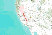
The Virginia Department of Conservation and Recreation – Natural Heritage Program (DCRDNH) and the Florida Natural Areas Inventory (FNAI) at Florida State University (collectively, Project Partners) were funded by the South Atlantic Landscape Conservation Cooperative (SALCC) in April 2015 to develop ten species distribution models (SDM) of priority at-risk and range-restricted species (Ambystoma cingulatum, Echinacea laevigata, Heterodon simus, Lindera melissifolia, Lythrum curtissii, Notophthalmus perstriatus, Phemeranthus piedmontanus, Rhus michauxii, and Schwalbea americana) for the purposes of incorporating the models and supporting information on the conservation and management needs of the species into the...
The Virginia Department of Conservation and Recreation – Natural Heritage Program (DCRDNH) and the Florida Natural Areas Inventory (FNAI) at Florida State University (collectively, Project Partners) were funded by the South Atlantic Landscape Conservation Cooperative (SALCC) in April 2015 to develop ten species distribution models (SDM) of priority at-risk and range-restricted species (Ambystoma cingulatum, Echinacea laevigata, Heterodon simus, Lindera melissifolia, Lythrum curtissii, Notophthalmus perstriatus, Phemeranthus piedmontanus, Rhus michauxii, and Schwalbea americana) for the purposes of incorporating the models and supporting information on the conservation and management needs of the species into the...
These datasets were developed to represent the geographic distribution of Plantago ovata in the Mojave Desert. This data release consists of two raster spatial layers (GeoTIFF) reflecting predicted habitat for the species within the Mojave Desert and the standard error in predictions. The habitat layer (raster dataset) is a continuous probability distribution of suitable habitat where values range from 0 (very low probability of species occurrence) to 1 (very high probability of species occurrence). An additional raster dataset provides the standard error in habitat predictions calculated among alternative habitat models: users should evaluate both the habitat and standard error datasets and exercise prudence when...
Preserving native species diversity is fundamental to ecosystem conservation. Selecting appropriate native species for use in restoration is a critical component of project design and may emphasize species attributes such as life history, functional type, pollinator services, and nutritional value for wildlife. Determining which species are likely to establish and persist in a particular environment is a key consideration. Species distribution models (SDMs) characterize relationships between species occurrences and the physical environment (e.g., climate, soil, topographic relief) and provide a mechanism for assessing which species may successfully propagate at a restoration site. In conjunction with information...
Categories: Data;
Types: Downloadable,
GeoTIFF,
Map Service,
Raster;
Tags: Arizona,
California,
Mojave,
Nevada,
Utah,
Here we present the map of probable suitable habitat for Orcutt’s woody aster (Xylorhiza orcuttii). The data indicate both how many models predicted each location to be suitable for the species, and the average standardized habitat suitability score for each location.Data are presented at a spatial resolution of 10 m pixels, which was required to harmonize the original model inputs. However, maps of suitable habitat should be used at a resolution no smaller than 360 m (i.e., 36 pixels x 36 pixels), which corresponds with the resolution of the coarsest model input. This product can be used to inform future conservation, planning, and management actions in the California desert. Complete methods and other additional...
Here we present the map of probable suitable habitat for Mojave monkeyflower (Mimulus mohavensis). The data indicate both how many models predicted each location to be suitable for the species, and the average standardized habitat suitability score for each location.Data are presented at a spatial resolution of 10 m pixels, which was required to harmonize the original model inputs. However, maps of suitable habitat should be used at a resolution no smaller than 360 m (i.e., 36 pixels x 36 pixels), which corresponds with the resolution of the coarsest model input. This product can be used to inform future conservation, planning, and management actions in the California desert. Complete methods and other additional...
Here we present the map of probable suitable habitat for San Bernardino milk-vetch (Astragalus bernardinus). The data indicate both how many models predicted each location to be suitable for the species, and the average standardized habitat suitability score for each location.Data are presented at a spatial resolution of 10 m pixels, which was required to harmonize the original model inputs. However, maps of suitable habitat should be used at a resolution no smaller than 360 m (i.e., 36 pixels x 36 pixels), which corresponds with the resolution of the coarsest model input. This product can be used to inform future conservation, planning, and management actions in the California desert. Complete methods and other...
Here we present the map of probable suitable habitat for Parish’s daisy (Erigeron parishii). The data indicate both how many models predicted each location to be suitable for the species, and the average standardized habitat suitability score for each location.Data are presented at a spatial resolution of 10 m pixels, which was required to harmonize the original model inputs. However, maps of suitable habitat should be used at a resolution no smaller than 360 m (i.e., 36 pixels x 36 pixels), which corresponds with the resolution of the coarsest model input. This product can be used to inform future conservation, planning, and management actions in the California desert. Complete methods and other additional information...
Here we present the map of potential suitable habitat for Mojave tarplant (Deinandra mohavensis). The data indicate both how many models predicted each location to be potentially suitable for the species and the average standardized habitat suitability score for each location.Data are presented at a spatial resolution of 10 m pixels, which was required to harmonize the original model inputs. However, maps of suitable habitat should be used at a resolution no smaller than 360 m (i.e., 36 pixels x 36 pixels), which corresponds with the resolution of the coarsest model input. These data are intended to be used only to target future plant surveys in areas where new occurrences are most likely to benefit future habitat...
Here we present the map of potential suitable habitat for Barstow woolly sunflower (Eriophyllum mohavense). The data indicate both how many models predicted each location to be potentially suitable for the species and the average standardized habitat suitability score for each location.Data are presented at a spatial resolution of 10 m pixels, which was required to harmonize the original model inputs. However, maps of suitable habitat should be used at a resolution no smaller than 360 m (i.e., 36 pixels x 36 pixels), which corresponds with the resolution of the coarsest model input. These data are intended to be used only to target future plant surveys in areas where new occurrences are most likely to benefit future...
Here we present the map of potential suitable habitat for Red Rock poppy (Eschscholzia minutiflora ssp. twisselmannii). The data indicate both how many models predicted each location to be potentially suitable for the species and the average standardized habitat suitability score for each location.Data are presented at a spatial resolution of 10 m pixels, which was required to harmonize the original model inputs. However, maps of suitable habitat should be used at a resolution no smaller than 360 m (i.e., 36 pixels x 36 pixels), which corresponds with the resolution of the coarsest model input. These data are intended to be used only to target future plant surveys in areas where new occurrences are most likely to...
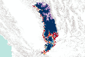
Here we present the maps of potential suitable habitat for 41 of the 43 rare plants in the California desert. The data indicate both how many models predicted each location to be potentially suitable for the species and the average standardized habitat suitability score for each location.Data are presented at a spatial resolution of 10 m pixels, which was required to harmonize the original model inputs. However, maps of suitable habitat should be used at a resolution no smaller than 360 m (i.e., 36 pixels x 36 pixels), which corresponds with the resolution of the coarsest model input. These data are intended to be used only to target future plant surveys in areas where new occurrences are most likely to benefit...
Here we present the map of potential suitable habitat for Kelso Creek monkey flower (Erythranthe shevockii (now Mimulus shevockii)). The data indicate both how many models predicted each location to be potentially suitable for the species and the average standardized habitat suitability score for each location.Data are presented at a spatial resolution of 10 m pixels, which was required to harmonize the original model inputs. However, maps of suitable habitat should be used at a resolution no smaller than 360 m (i.e., 36 pixels x 36 pixels), which corresponds with the resolution of the coarsest model input. These data are intended to be used only to target future plant surveys in areas where new occurrences are...
Here we present the multispecies map of probable suitable habitat in the project area. The multispecies map of probable suitable habitat combines data from all 26 species for which probable suitable habitat was mapped and indicates the number of species for which probable suitable habitat is predicted at each location. Data are presented at a spatial resolution of 10 m pixels, which was required to harmonize the original model inputs. However, maps of suitable habitat should be used at a resolution no smaller than 360 m (i.e., 36 pixels x 36 pixels), which corresponds with the resolution of the coarsest model input. This product can be used to inform future conservation, planning, and management actions in the California...

Predicted probability of fisher year-round occurrence created with Maxent (Phillips et al. 2006) using fisher detections (N = 302, spanning 1990 – 2011) and five predictor variables: mean annual precipitation, mean summer (July – September) precipitation, mean understory index (fraction of grass vegetation carbon in forest), mean forest carbon (g C m2), and mean fraction of vegetation carbon in forest. Predictor variables had a grid cell size of 800 m by 800 m, vegetation variables were simulated with MC1 dynamic global vegetation model (Bachelet et al. 2001) and historical climate variables were provided by the PRISM GROUP (Daly et al. 2008). This fisher distribution model has a 10-fold cross-validated AUC of...
Future (2076-2095) predicted probability of marten year-round occurrence projected under the A2 emissions scenario with the PCM1 GCM (Washington et al. 2000; Meehl et al. 2003). The projected marten distribution was created with Maxent (Phillips et al. 2006) using marten detections (N = 302, spanning 1990 – 2011) and nine predictor variables: mean annual precipitation, mean summer (July – September) precipitation, mean summer temperature amplitude, mean annual temperature maximum, mean fraction of vegetation carbon burned, mean understory index, mean vegetation carbon (g C m2), modal vegetation class, and average maximum tree LAI. Predictor variables had a grid cell size of 10 km, vegetation variables were simulated...
The Nature Conservancy (TNC) has derived climate suitability forecasts for most species of trees and shrubs considered to be ecological dominants of terrestrial Californian habitat types. Our plant projections are compiled as decision support tools to help Conservancy project staff, as well as our external partners, develop the necessary plans, priorities and strategies to successfully adapt to uncertain changes in future climate. In the recently completed Southern Sierra Partnership's 2010 Climate-Adapted Conservation Plan for the Southern Sierra Nevada and Tehachapi Mountains, species and habitat forecasts shown here informed the development of a regional conservation design that explicitly incorporates long-term...

The Nature Conservancy (TNC) has derived climate suitability forecasts for most species of trees and shrubs considered to be ecological dominants of terrestrial Californian habitat types. Our plant projections are compiled as decision support tools to help Conservancy project staff, as well as our external partners, develop the necessary plans, priorities and strategies to successfully adapt to uncertain changes in future climate. In the recently completed Southern Sierra Partnership's 2010 Climate-Adapted Conservation Plan for the Southern Sierra Nevada and Tehachapi Mountains, species and habitat forecasts shown here informed the development of a regional conservation design that explicitly incorporates long-term...
|

|
