Filters: Tags: streamflow (X)
1,086 results (85ms)|
Filters
|
The High Resolution National Hydrography Dataset Plus (NHDPlus HR) is an integrated set of geospatial data layers, including the best available National Hydrography Dataset (NHD), the 10-meter 3D Elevation Program Digital Elevation Model (3DEP DEM), and the National Watershed Boundary Dataset (WBD). The NHDPlus HR combines the NHD, 3DEP DEMs, and WBD to create a stream network with linear referencing, feature naming, "value added attributes" (VAAs), elevation-derived catchments, and other features for hydrologic data analysis. The stream network with linear referencing is a system of data relationships applied to hydrographic systems so that one stream reach "flows" into another and "events" can be tied to and traced...
The High Resolution National Hydrography Dataset Plus (NHDPlus HR) is an integrated set of geospatial data layers, including the best available National Hydrography Dataset (NHD), the 10-meter 3D Elevation Program Digital Elevation Model (3DEP DEM), and the National Watershed Boundary Dataset (WBD). The NHDPlus HR combines the NHD, 3DEP DEMs, and WBD to create a stream network with linear referencing, feature naming, "value added attributes" (VAAs), elevation-derived catchments, and other features for hydrologic data analysis. The stream network with linear referencing is a system of data relationships applied to hydrographic systems so that one stream reach "flows" into another and "events" can be tied to and traced...
The High Resolution National Hydrography Dataset Plus (NHDPlus HR) is an integrated set of geospatial data layers, including the best available National Hydrography Dataset (NHD), the 10-meter 3D Elevation Program Digital Elevation Model (3DEP DEM), and the National Watershed Boundary Dataset (WBD). The NHDPlus HR combines the NHD, 3DEP DEMs, and WBD to create a stream network with linear referencing, feature naming, "value added attributes" (VAAs), elevation-derived catchments, and other features for hydrologic data analysis. The stream network with linear referencing is a system of data relationships applied to hydrographic systems so that one stream reach "flows" into another and "events" can be tied to and traced...
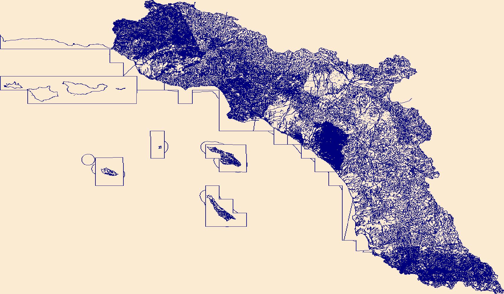
The Russian River Watershed (RRW) covers about 1,300 square miles (without Santa Rosa Plain) of urban, agricultural, and forested lands in northern Sonoma County and southern Mendocino County, California. Communities in the RRW depend on a combination of Russian River water and groundwater to meet their water-supply demands. Water is used primarily for agricultural irrigation, municipal and private wells supply, and commercial uses - such as for wineries and recreation. Annual rainfall in the RRW is highly variable, making it prone to droughts and flooding from atmospheric river events. In order to better understand surface-water and groundwater issues, the USGS is creating a Coupled Ground-Water and Surface-Water...
Categories: Project;
Types: Map Service,
OGC WFS Layer,
OGC WMS Layer,
OGC WMS Service;
Tags: California,
Groundwater-surface water interactions,
Hydrology,
Russian River,
Russian River Watershed,
The USGS Wyoming-Montana Water Science Center (WY–MT WSC) completed a report (Sando and McCarthy, 2018) documenting methods for peak-flow frequency analysis following implementation of the Bulletin 17C guidelines. The methods are used to provide estimates of peak-flow quantiles for 66.7-, 50-, 42.9-, 20-, 10-, 4-, 2-, 1-, 0.5-, and 0.2-percent annual exceedance probabilities (AEPs) for selected streamgages operated by the WY–MT WSC. This data release presents peak-flow frequency analyses for selected streamgages in and near the Milk River Basin, Montana, that were based on methods described by Sando and McCarthy (2018).
Categories: Data;
Types: Map Service,
OGC WFS Layer,
OGC WMS Layer,
OGC WMS Service;
Tags: Alberta,
Land,
Milk River,
Milk River Headwaters,
Montana,
This data release contains a comma-delimited ascii file of four same-day, discrete discharge measurements made at sites along selected reaches of Kanahā Stream, Maui, Hawai'i on June 1, 2022. These discrete discharge measurements form what is commonly referred to as a “seepage run.” The intent of the seepage run is to quantify the spatial distribution of streamflow along the reach during fair-weather, low-flow conditions, generally characterized by negligible direct runoff within the reach. The measurements can be used to characterize the net seepage of water into (water gain) or out of (water loss) the stream channel between measurement sites provided that the measurements were made during stable, nonchanging flow...
To provide daily mean streamflow values at ungaged (partial-record) sites within the Yankee Fork Salmon River watershed, the U.S. Geological Survey (USGS), in cooperation with U.S. Bureau of Reclamation, used discharge measurements at three partial-record sites and related those measurements to a nearby USGS real-time streamgage (index site). Daily mean streamflow was estimated by developing a regression relationship between each partial-record site and the index site for water years 2012-2019. These data are intended to provide daily mean streamflow estimates at partial-record sites as part of a larger study (Clark and others, 2021) to estimate sediment loading for each site.
Categories: Data;
Types: Map Service,
OGC WFS Layer,
OGC WMS Layer,
OGC WMS Service;
Tags: Custer,
Hydrology,
Idaho,
Land,
North America,
This data release contains a comma-delimited ascii file of three same-day, discrete discharge measurements made at sites along selected reaches of Hāhālawe Stream, Maui, Hawai'i on August 12, 2021. These discrete discharge measurements form what is commonly referred to as a “seepage run.” The intent of the seepage run is to quantify the spatial distribution of streamflow along the reach during fair-weather, low-flow conditions, generally characterized by negligible direct runoff within the reach. The measurements can be used to characterize the net seepage of water into (water gain) or out of (water loss) the stream channel between measurement sites provided that the measurements were made during stable, nonchanging...
This data release contains a comma-delimited ascii file of two same-day, discrete discharge measurements made at sites along selected reaches of Keawewai Stream, Hawai'i on September 17, 2021. These discrete discharge measurements form what is commonly referred to as a “seepage run.” The intent of the seepage run is to quantify the spatial distribution of streamflow along the reach during fair-weather, low-flow conditions, generally characterized by negligible direct runoff within the reach. The measurements can be used to characterize the net seepage of water into (water gain) or out of (water loss) the stream channel between measurement sites provided that the measurements were made during stable, nonchanging...
This data release supersedes Thorson, J.M., Dunham, J.B., Heck, M.P., Hockman-Wert, D.P., and Mintz, J.M., 2020, Stream Temperature in the Northern Great Basin region of Southeastern Oregon, 2016-2019: U.S. Geological Survey data release, https://doi.org/10.5066/P924MOCB. This dataset includes hourly stream and air temperature data from 124 sites throughout the Northern Great Basin region of SE Oregon. Data loggers were deployed June through September of 2016 and downloaded each subsequent summer through 2021. The SE_OR_Stream_Temps and SE_OR_Air_Temps files contain temperature data (in C°) by logger serial number and site for the study period. The SE_OR_Wet_Dry delineation file contains daily flow status estimates...
Categories: Data;
Types: Downloadable,
Map Service,
OGC WFS Layer,
OGC WMS Layer,
Shapefile;
Tags: Climatology,
Grant County,
Harney County,
Hydrology,
Intermittent,
The USGS Wyoming-Montana Water Science Center (WY–MT WSC) completed a report (Sando and McCarthy, 2018) documenting methods for peak-flow frequency analysis following implementation of the Bulletin 17C guidelines. The methods are used to provide estimates of peak-flow quantiles for 66.7-, 50-, 42.9-, 20-, 10-, 4-, 2-, 1-, 0.5-, and 0.2-percent annual exceedance probabilities (AEPs) for selected USGS streamgages. This data release presents peak-flow frequency analyses for selected streamgages on tributaries of the Bighorn, Tongue, and Lower Yellowstone Rivers, based on data through water year 2021 that were based on methods described by Sando and McCarthy (2018).
Categories: Data;
Types: Map Service,
OGC WFS Layer,
OGC WMS Layer,
OGC WMS Service;
Tags: Bighorn,
Bighorn County,
Land,
Little Bighorn,
Lower Bighorn,
IMPORTANT NOTE: This dataset includes spatial locations where streamflow permanence observations (continuous flow, discontinuous flow, and dry) were recorded using the FLOwPER (FLOw PERmanence) field survey available in the Survey 123 and S1 mobile application. Additional information to describe the field conditions are included as part of the survey. Field observations in the FLOwPER Database have not been processed for quality control including spatial data accuracy or association with a stream network such as the National Hydrography Dataset. Streamflow permanence observations are collected from several governmental and non-governmental organizations on a continuing basis. This data release is formatted as a...
Note: this data release has been deprecated. Please see new data release here: https://doi.org/10.5066/P9C8NYTO. This data release has components of an analysis of the coverage, resolution, and representation of national public interests in streamflow information by the USGS streamflow gaging network that was active in water year 2020. The workflow for the analysis is implemented as scripts and functions in the statistical programming language R. The spatial framework for the analysis is based on from the National Hydrography Dataset medium resolution (1:100,000) segments, 12-digit Hydrologic Unit from the Watershed Boundary Dataset, and sites where USGS operated a streamflow gage in Water Year 2020. The analysis...
Categories: Data;
Tags: Hydrology,
Information Sciences,
United States,
Water Quality,
Water Resources,

This dataset is available from the typeName 'NWC:gagesii_basins' in the referenced Web Feature Service. This dataset, termed "GAGES II", an acronym for Geospatial Attributes of Gages for Evaluating Streamflow, version II, provides geospatial data and classifications for 9,322 stream gages maintained by the U.S. Geological Survey (USGS). It is an update to the original GAGES, which was published as a Data Paper on the journal Ecology's website (Falcone and others, 2010b) in 2010. The GAGES II dataset consists of gages which have had either 20+ complete years (not necessarily continuous) of discharge record since 1950, or are currently active, as of water year 2009, and whose watersheds lie within the United States,...
Categories: Data;
Types: Citation,
Map Service,
OGC WFS Layer;
Tags: Alabama,
Alaska,
All 50 states,
Arizona,
Arkansas,
Understanding how changing climatic conditions affect streamflow volume and timing is critical for effective water management. In the Rio Grande Basin of the southwest U.S., decreasing snowpack, increasing minimum temperatures, and decreasing streamflow have been observed in recent decades, but the effects of hydroclimatic changes on baseflow, or groundwater discharge to streams, have not been investigated. The dataset created in this data release was used to help support a study to determine how trends in precipitation, snowpack accumulation, and snowmelt rate relate to streamflow, baseflow, and the hydrologic partitioning of baseflow and runoff at 12 sites in the Upper Rio Grande Basin (URGB) during 1980 to 2015....
Streamflow permanence probability rasters, 2004-2016. Version 2.0. Predicted probability of streamflow permanence, values between dry (0) and wet (1).
The U.S. Geological Survey (USGS) has developed the PRObability of Streamflow PERmanence (PROSPER) model, a GIS raster-based empirical model that provides streamflow permanence probabilities (probabilistic predictions) of a stream channel having year-round flow for any unregulated and minimally-impaired stream channel in the Pacific Northwest region, U.S. The model provides annual predictions for 2004-2016 at a 30-m spatial resolution based on monthly or annually updated values of climatic conditions and static physiographic variables associated with the upstream basin (Raw streamflow permanence probability rasters). Predictions correspond to pixels on the channel network consistent with the medium resolution National...
This dataset includes stream temperature data from 34 sites in the Donner und Blitzen basin of SE Oregon. Data loggers were deployed in September of 2018 and downloaded each subsequent summer/fall through 2021. The EcoDrought_Temperature file contains temperature data (in C°) by logger serial number and site for the study period. The EcoDrought_Points spatial data layer contains site locations, geographic information, data summaries, mean August stream temperatures, and modeled NorWeST stream temperatures. The EcoDrought_Wet_Dry delineation file contains daily flow status estimates derived from stream temperature data for each site. The EcoDrought_Site_Visit file contains the date and time of the site visit along...
Categories: Data;
Types: Downloadable,
Map Service,
OGC WFS Layer,
OGC WMS Layer,
Shapefile;
Tags: Donner und Blitzen River,
Harney County,
Hydrology,
Intermittent,
Little Blitzen River,
This child page contains a zipped folder which contains all files necessary to run trend models and produce results published in U.S. Geological Scientific Investigations Report 2022–5013 [Tatge, W.S., Nustad, R.A., and Galloway, J.M., 2022, Evaluation of Salinity and Nutrient Conditions in the Heart River Basin, North Dakota, 1970-2020: U.S. Geological Survey Scientific Investigations Report 2022-5013]. The folder contains: six files required to run the R–QWTREND trend analysis tool; a readme.txt file; a flowtrendData.RData file; an allsiteinfo.table.csv file, a folder called "scripts", and a folder called "waterqualitydata". The "scripts" folder contains the scripts that can be used to reproduce the results found...
Categories: Data;
Types: Map Service,
OGC WFS Layer,
OGC WMS Layer,
OGC WMS Service;
Tags: Heart River,
North Dakota,
datasets,
streamflow,
water quality
These data consist of rectified aerial photographs, measurements of active channel width, measurements of river and floodplain bathymetry and topography, and ancillary data. These data are specific to the corridor of the Green River in Canyonlands National Park between Horseshoe Canyon and Deadhorse Canyon, Utah. The time period for these data are 1940 to 2018. The 'Channel Width' shapefile data are measurements of the active channel width of the Green River at 1-km intervals in and near Canyonlands National Park, Utah. The 'Mineral Bottom' csv data are river channel cross-sections for a 3-km study reach of the Green River upstream from Mineral Bottom, Utah. The study reach is near the mouth of Hell Roaring Canyon,...
|

|
