Filters: Tags: timber harvest (X)
15 results (16ms)|
Filters
Date Range
Extensions (Less) Types (Less) Contacts (Less)
Categories (Less) Tag Types
|
Synopsis: This study analyzed the effects of vegetation change on hydrological fluctuations in the Columbia River basin over the last century using two land cover scenarios. The first scenario was a reconstruction of historical land cover vegetation, c. 1900. The second scenario was more recent land cover as estimated from remote sensing data for 1990. The results show that, hydrologically, the most important vegetation-related change has been a general tendency towards decreased vegetation maturity in the forested areas of the basin. This general trend represents a balance between the effects of logging and fire suppression. In those areas where forest maturity has been reduced as a result of logging, wintertime...
Categories: Publication;
Types: Citation,
Map Service,
OGC WFS Layer,
OGC WMS Layer,
OGC WMS Service;
Tags: British Columbia,
Idaho,
Land use configuration,
Montana,
Natural cover amount,

Dataset displays timber harvest volume by county in Montana for calendar year 2009 based on a census of all timber processors in the state and other public records.
Synopsis: Remotely sensed data and GIS were used to compare the effects of clear-cutting and road-building on the landscape pattern of the Bighorn National Forest, Wyoming. Landscape patterns were quantified for each of 12 watersheds on a series of four maps that differed only in the degree of clear-cutting and road density. Researchers analyzed several landscape pattern metrics for the landscape as a whole and for the lodgepole pine and spruce/fir cover classes across the four maps to determine the relative effects of clear-cutting and road building on the pattern of each watershed. At both the landscape and cover class scales, clear-cutting and road building resulted in increased fragmentation as represented...
Categories: Publication;
Types: Citation,
Map Service,
OGC WFS Layer,
OGC WMS Layer,
OGC WMS Service;
Tags: Land use configuration,
Landscape fragmentation,
Natural cover amount,
Wyoming,
configuration,
Conclusions:Forest clearcutting differentialy affects birds of different ages. There is a threshold distance between reserves below which birds do not mind crossing clear cuts, making corridors more important as clearcut area and distance between forest reserves expandsThresholds/Learnings:
Categories: Publication;
Types: Citation;
Tags: Alberta,
Land use configuration,
Landscape fragmentation,
Natural cover amount,
birds,
Conclusions:Chemical concentrations, turbidity, changes in microclimate, and sediment production were affected to varying degrees by forest harvesting. No significant differences were found between pre-harvest and post-harvest concentrations except for calcium which was 5 times higher and sodium which was 20 times higher in the harvested watersheds. Concentrations declined over the 3 year post-harvest span.Turbidity and suspended sediment increased with road construction but declined rapidly to nearly background levels after 2 years. Air temperature increased after harvesting in all of the smaller watersheds but stream temperature was not affected.Thresholds/Learnings:
Categories: Publication;
Types: Citation;
Tags: Land use configuration,
Natural cover amount,
Washington,
air tmeperature,
forest,
This layer depicts the total volume of timber harvested in 2010 measured in thousands of board feet. Derived tabular data are based on the county level. Data were transformed to a standardized scale based on their maximum values. Hence, all values range between 0 and 1.
Conclusions:The occurence of bull trout in mid-boreal stream is negatively related to two metrics of industrial activity: percent forest harvesting and road density. Bull trout abundance was positively related to elevation, and negatively related to stream width, slope, and levels of forest harvesting.Thresholds/Learnings:Timber harvest on up to 35% or more of individual subbasins is projected to result in the extripation of bull trout from up to 43% of stream reaches, especially those that support high densities of bull trout.
Categories: Publication;
Types: Citation;
Tags: Land use configuration,
Landscape fragmentation,
Natural cover amount,
Western Alberta,
boreal forest,
Synopsis: This study monitored the response of a species of pine bark beetle, Trypodendron lineatum, to direct and indirect measures of habitat availability in a forest subjected to various levels of harvest intensities. Four stand types (conifer dominated, mixed, deciduous dominated, and deciduous dominated with conifer understory) were treated with four levels of harvest intensity (unharvested, 50%, 80%, and 90% harvested). Prior to harvest, the pine bark beetle was most abundant in stands with many host trees (conifer dominated stands). In the first and second summers after harvest, pine beetle abundance increased exponentially with percent spruce cover and the number of spruce stumps in the stand. Beetles were...
Categories: Publication;
Types: Citation,
Map Service,
OGC WFS Layer,
OGC WMS Layer,
OGC WMS Service;
Tags: Alberta,
Land use configuration,
Landscape fragmentation,
Natural cover amount,
Natural cover heterogeneity,

This dataset represents the suitable areas for timber harvest on the Tongass National Forest

These data were released prior to the October 1, 2016 effective date for the USGS’s policy dictating the review, approval, and release of scientific data as referenced in USGS Survey Manual Chapter 502.8 Fundamental Science Practices: Review and Approval of Scientific Data for Release. Using available aerial photos from approximately a 15-year period, changes in timber harvest were mapped in the Little North Santiam River Basin, Oregon. Timber harvest plots as seen on digital orthophotos from 1995, 2000, 2005, and 2009 were digitized and attributed based on harvest type or purpose: clearcut, thinning, or development.
Conclusions:Concentrations of refractory compounds (tannins and lignins) increased by a factor of about 4 after clear-cutting and persisted at the higher concentration for several years. Humic substances also increased but the effect only lasted about 2 years.Thresholds/Learnings:
Categories: Publication;
Types: Citation;
Tags: Alberta,
Natural cover amount,
local,
riparian,
timber harvest,
Conclusions:Forest harvesting impacts stream water chemistry by: increasing geological weathering rates due to exposing land surfaces to greater temperature, decreasing acidity of runoff, decreasing organic matter and litter inputs to streams, increasing anion exchange capacity of a soil by lowering pH, etc.Thresholds/Learnings:
Categories: Publication;
Types: Citation;
Tags: Canada and USA,
Natural cover amount,
forest,
logging,
meso-regional,
Conclusions: Marten capture rates were negatively correlated with increasing proximity of open areas and increasing extent of high-contrast edges. Forested landscapes were unsuitable for martens when the average nearest-neighbor distance between open, non-forested patches was <100m. Thresholds/Learnings: Synopsis: This study aimed to determine whether American marten abundance changed with incremental increases in habitat fragmentation caused by the combined effects of natural openings and timber clearcuts. Researchers evaluated differences in marten capture rates in 18 study sites with different levels of fragmentation. Martens appeared to respond negatively to low levels of habitat fragmentation, even with remaining...
Categories: Publication;
Types: Citation,
Map Service,
OGC WFS Layer,
OGC WMS Layer,
OGC WMS Service;
Tags: American martens,
Land use configuration,
Landscape fragmentation,
Natural cover amount,
Utah,
Conclusions: In response to logging, songbirds demonstrated “habitat compensation” by moving into different adjacent habitats across a fragmented landscape. Thresholds/Learnings: Synopsis: This study investigates the degree to which species respond differently to logging across different scales in Alberta’s boreal mixed-wood forests. Researchers tracked changes in the composition and abundance of songbirds at the patch-level and landscape level, finding significant variation between the two spatial scales. The results suggest that predictions of organism response based on the island biogeographic model are limited, and that—while responses varied across species—songbirds demonstrated “habitat compensation” by moving...
Categories: Publication;
Types: Citation,
Map Service,
OGC WFS Layer,
OGC WMS Layer,
OGC WMS Service;
Tags: Alberta,
Land use configuration,
Landscape fragmentation,
Natural cover amount,
birds,

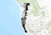
This dataset depicts clearcuts on the Tongass National Forest (Alaska, USA) prior to 2000. This dataset is part of a larger analysis of road building and timber harvest on the Tongass National Forest, compiled for the report Scientific Basis for Roadless Area Conservation (http://consbio.org/what-we-do/scientific-basis-for-roadless-area-conservation/?searchterm=tongass), pp 70-73. Prior to 1960, timber extraction was primarily accomplished from the ocean shore. Following 1960, due to increased road-building activity, inland forests were increasingly harvested. A spatial time-series analysis of road-building and clearcuts by decade, as depicted by this and other layers within this analysis, demonstrates this trend....
|

|
