Filters: Tags: {"type":"Publication"} (X)
103 results (94ms)|
Filters
Date Range
Extensions (Less) Types (Less)
Contacts (Less)
Categories (Less) Tag Schemes Tags (with Type=Publication )
|


Categories: Publication;
Types: Citation,
Map Service,
OGC WFS Layer,
OGC WMS Layer,
OGC WMS Service;
Tags: Data Series
Sexual segregation occurs frequently in sexually dimorphic species, and it may be influenced by differential habitat requirements between sexes or by social or evolutionary mechanisms that maintain separation of sexes regardless of habitat selection. Understanding the degree of sex-specific habitat specialization is important for management of wildlife populations and the design of monitoring and research programs. Using mid-summer aerial survey data for Dall’s sheep (Ovis dalli dalli) in southern Alaska during 1983–2011, we assessed differences in summer habitat selection by sex and reproductive status at the landscape scale in Wrangell-St. Elias National Park and Preserve (WRST). Males and females were highly...
Categories: Data,
Publication;
Types: Citation,
Downloadable,
Map Service,
OGC WFS Layer,
OGC WMS Layer,
Shapefile;
Tags: Journal of Mammalogy
The Yukon River Basin, underlain by discontinuous permafrost, has experienced a warming climate over the last century that has altered air temperature, precipitation, and permafrost. We investigated a water chemistry database from 1982 to 2014 for the Yukon River and its major tributary, the Tanana River. Significant increases of Ca, Mg, and Na annual flux were found in both rivers. Additionally, SO4 and P annual flux increased in the Yukon River. No annual trends were observed for dissolved organic carbon (DOC) from 2001 to 2014. In the Yukon River, Mg and SO4 flux increased throughout the year, while some of the most positive trends for Ca, Mg, Na, SO4, and P flux occurred during the fall and winter months. Both...
Categories: Data,
Publication;
Types: Citation,
Downloadable,
Map Service,
OGC WFS Layer,
OGC WMS Layer,
Shapefile;
Tags: Geophysical Research Letters
Estimates of the seasonal and interannual exchanges of carbon dioxide (CO2) and methane (CH4) between land ecosystems north of 45°N and the atmosphere are poorly constrained, in part, because of uncertainty in the temporal variability of water-inundated land area. Here we apply a process-based biogeochemistry model to evaluate how interannual changes in wetland inundation extent might have influenced the overall carbon dynamics of the region during the time period 1993–2004. We find that consideration by our model of these interannual variations between 1993 and 2004, on average, results in regional estimates of net methane sources of 67.8 ± 6.2 Tg CH4 yr−1, which is intermediate to model estimates that use two...
Categories: Data,
Publication;
Types: Citation,
Downloadable,
Map Service,
OGC WFS Layer,
OGC WMS Layer,
Shapefile;
Tags: Environmental Research Letters
Categories: Publication;
Types: Citation,
Map Service,
OGC WFS Layer,
OGC WMS Layer,
OGC WMS Service;
Tags: Scientific Investigations Report
Categories: Publication;
Types: Citation,
Map Service,
OGC WFS Layer,
OGC WMS Layer,
OGC WMS Service;
Tags: Data Series
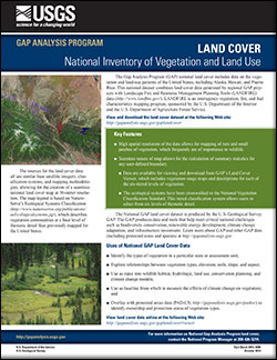
The Gap Analysis Program (GAP) produces data and tools that help meet critical national challenges such as biodiversity conservation, renewable energy development, climate change adaptation, and infrastructure investment. The GAP national land cover includes data on the vegetation and land-use patterns of the United States, including Alaska, Hawaii, and Puerto Rico. This national dataset combines land cover data generated by regional GAP projects with Landscape Fire and Resource Management Planning Tools (LANDFIRE) data. LANDFIRE is an interagency vegetation, fire, and fuel characteristics mapping program, sponsored by the U.S. Department of the Interior and the U.S. Department of Agriculture Forest Service.
|

|
