Filters: partyWithName: Schaefer, J.R. (X)
14 results (35ms)|
Following the May 2005 acid crater lake flood at Chiginagak volcano, DGGS has been monitoring crater lake water that flows into Indecision Creek, Mother Goose Lake, and the King Salmon River.This data table provides information on water samples collected between 2005 and 2011 near Chiginagak volcano, including:sample ID, latitude, longitude, location description, pH, and cation and anion chemistry results.
This data lists the historically active volcanoes of Alaska and the year of the last major eruptive event. The volcanoes listed meet at least one of the following criteria since 1700 CE: (1) documented, unquestioned eruption, or (2) a strongly suspected eruption, often an eruption documented in the historical account with very little information (current geologic knowledge must not contradict the eruption account), or (3) persistent (usually on the order of decades, but certainly longer than several months) fumaroles, with temperatures (where measured) within ~10 degrees C of the boiling point, or (4) significant, measured, volcanic-related, non-eruptive deformation, (5) documented earthquake swarm with strongly...
Okmok volcano, Aleutian Islands, Alaska, explosively erupted over a five-week period between July 12 and August 23, 2008. The eruption was predominantly phreatomagmatic, producing fine-grained tephra that covered most of northeastern Umnak Island. The eruption had a maximum Volcanic Explosivity Index (VEI) of 4, with eruption column heights up to 16 km during the opening phase. Several craters and a master tuff cone formed in the caldera as a result of phreatomagmatic explosions and accumulated tephra-fall and surge deposits. Ascending magma continuously interacted with an extensive shallow groundwater table in the caldera, resulting in the phreatomagmatic character of the eruption. Syneruptive explosion and collapse...
In preparation for bottom sediment coring at Mother Goose Lake, bathymetric data was collected using a Lowrance Sonar "fishfinder" (model LcX-17M) in August 2006 and August 2007. A 5-meter bathymetric contour map of the lake bottom was constructed using the GPS-sonar data in conjunction with field observations. The contour data and GPS location and depth data are provided in ESRI shapefile format for use in Geographic Information System (GIS) software.
This dataset consists of the vector digital GIS files that were used to create sheet 1 of the "Preliminary volcano-hazard assessment for Okmok Volcano, Umnak Island, Alaska" (DGGS RI 2004-3). The map area is centered around Okmok Volcano, on eastern Umnak Island. The data includes volcano-hazard zones for ballistics, ash accumulation, pyroclastic flows, floods and lahars, and debris avalanches. Also included in the dataset are roads, trails, seismic station locations, continuous GPS station locations, creeks, and the location of the Fort Glenn airstrip.
This data lists the historically active volcanoes of Alaska, their location in latitude/longitude decimal degrees, and the year of the last major eruptive event. The 52 volcanoes listed meet at least one of the following criteria since 1700 CE: (1) documented, unquestioned eruption, or (2) a strongly suspected eruption, often an eruption documented in the historical account with very little information (current geologic knowledge must not contradict the eruption account), or (3) persistent (usually on the order of decades, but certainly longer than several months) fumaroles, with temperatures (where measured) within ~10°C of the boiling point, or (4) significant, measured, volcanic-related, non-eruptive deformation,...
Following the May 2005 acid crater lake flood at Chiginagak volcano, DGGS has been monitoring crater lake water that flows into Indecision Creek, Mother Goose Lake, and the King Salmon River. This data table provides information on water samples collected between 2005 and 2012 near Chiginagak volcano, including: sample ID, latitude, longitude, location description, pH, and cation and anion chemistry results.
In response to significant morphologic changes in Okmok Caldera due to the phreatomagmatic eruption of Okmok volcano in 2009, a new digital elevation model was acquired to document and quantitatively assess the new volcanic features and altered hydrology within the caldera. This DEM dataset provides elevation data derived from a stereo pair of Worldview-1 satellite images acquired on January 21, 2010. In addition to the DEM, a shaded-relief image is also provided for easy visualization of the data.
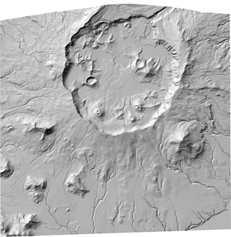
This shaded relief image of Okmok Volcano serves as the basemap for sheet 1 of the "Preliminary volcano-hazard assessment for Okmok Volcano, Umnak Island, Alaska" (DGGS RI 2004-3). The map area is centered around Okmok Volcano, on eastern Umnak Island. SRTM and AirSAR DEM datasets were combined in ArcGIS to produce a georeferenced shaded relief TIFF image of Okmok Volcano.
Mount Chiginagak is a hydrothermally active volcano on the Alaska Peninsula, approximately 170 km south-southwest of King Salmon, Alaska. This small stratovolcano, approximately 8 km in diameter, has erupted through Tertiary to Permian sedimentary and igneous rocks. The eruptive products of Chiginagak volcano record a history of chiefly andesite lava flows and associated block-and-ash flows. The oldest lavas exposed are Pleistocene in age and are found everywhere around the edifice except in the northeast sector, where Holocene lava flows dominate the landscape. Holocene activity has covered the northeast flank with rubbly-topped andesite lava flows that extend as far as 4.6 km from their source vent at the summit...
Mount Chiginagak is a hydrothermally active volcano on the Alaska Peninsula, approximately 170 km south-southwest of King Salmon, Alaska. This small stratovolcano, approximately 8 km in diameter, has erupted through Tertiary to Permian sedimentary and igneous rocks. The eruptive products of Chiginagak volcano record a history of chiefly andesite lava flows and associated block-and-ash flows. The oldest lavas exposed are Pleistocene in age and are found everywhere around the edifice except in the northeast sector, where Holocene lava flows dominate the landscape. Holocene activity has covered the northeast flank with rubbly-topped andesite lava flows that extend as far as 4.6 km from their source vent at the summit...
Fisher volcano, containing the largest Holocene caldera in the Aleutian volcanic arc, is an active volcano near the center of Unimak Island, about 120 kilometers southwest of Cold Bay and about 175 kilometers northeast of Dutch Harbor. The volcano is composed of numerous small volcanic centers around and within a large, oval caldera 12 by 18 kilometers in diameter and 500 to 1,000 meters deep that formed during a catastrophic eruption about 9,400 years ago. Since then, more than 30 separate vents inside and outside the caldera have erupted; the most recent eruption occurred in 1826. These eruptions have produced lava flows and widespread tephra (volcanic ash) deposits, and have occasionally been accompanied by large...
This data lists the historically active volcanoes of Alaska and the year of the last major eruptive event. The volcanoes listed meet at least one of the following criteria since 1700 CE: 1) Documented, unquestioned eruption OR 2) A strongly suspected eruption, often an eruption documented in a historical account with very little information. Current geologic knowledge must not contradict the eruption account, OR 3) Persistent (usually on the order of decades, but certainly longer than several months) fumaroles, with temperatures (where measured) within approximately 10 degrees C of the boiling point, OR 4) Significant, measured, volcanic-related, non-eruptive deformation, OR 5) Documented earthquake swarm with strongly...
This 30-meter, horizontal, cell-size, shaded relief, georeferenced TIFF image of Okmok Volcano, Umnak Island, Alaska, was created by combining digital elevation model (DEM) data provided by NASA's shuttle radar topography mission (SRTM) and the aircraft-mounted synthetic aperture radar (AirSAR) mission.
|

|
