Filters: Tags: digital elevation model (X) > partyWithName: Alaska Division of Geological & Geophysical Surveys (X)
38 results (118ms)|
Filters
Date Range
Contacts Tag Types Tag Schemes |
The 0.53-second Sitka Alaska Digital Elevation Model provides bathymetric and topographic data in ASCII raster format of 0.53-second resolution in geographic coordinates.
In advance of design, permitting, and construction of a pipeline to deliver North Slope natural gas to out-of-state customers and Alaska communities, the Division of Geological & Geophysical Surveys (DGGS) has acquired LiDAR (Light Detection and Ranging) data along proposed pipeline routes, nearby areas of infrastructure, and regions where significant geologic hazards have been identified. LiDAR data will serve multiple purposes, but have primarily been collected to (1) evaluate active faulting, slope instability, thaw settlement, erosion, and other engineering constraints along proposed pipeline routes, and (2) provide a base layer for the state-federal GIS database that will be used to evaluate permit applications...
In May 2014 the Geophysical Institute at the University of Alaska Fairbanks (UAF) developed integrated bathymetricâtopographic digital elevation models (DEMs) of Skagway and Haines, Alaska, for the National Tsunami Hazard Mitigation Program (NTHMP). The DEMs are designed to fit within a nested hierarchy of similar DEMs of larger spatial extent but coarser resolution. The gridded DEMs will be used to support modeling of tsunami generation, propagation, and inundation. This report describes the various source datasets, data processing tasks and techniques, the surface interpolation, and quality assessment of the seamless 8/15-arcâsecond (~15 m) bathymetric-topographic DEMs. The data files are provided as ASCII...
In advance of design, permitting, and construction of a pipeline to deliver North Slope natural gas to out-of-state customers and Alaska communities, the Division of Geological & Geophysical Surveys (DGGS) has acquired LiDAR (Light Detection and Ranging) data along proposed pipeline routes, nearby areas of infrastructure, and regions where significant geologic hazards have been identified. LiDAR data will serve multiple purposes, but have primarily been collected to (1) evaluate active faulting, slope instability, thaw settlement, erosion, and other engineering constraints along proposed pipeline routes, and (2) provide a base layer for the state-federal GIS database that will be used to evaluate permit applications...
In advance of design, permitting, and construction of a pipeline to deliver North Slope natural gas to out-of-state customers and Alaska communities, the Division of Geological & Geophysical Surveys (DGGS) has acquired LiDAR (Light Detection and Ranging) data along proposed pipeline routes, nearby areas of infrastructure, and regions where significant geologic hazards have been identified. LiDAR data will serve multiple purposes, but have primarily been collected to (1) evaluate active faulting, slope instability, thaw settlement, erosion, and other engineering constraints along proposed pipeline routes, and (2) provide a base layer for the state-federal GIS database that will be used to evaluate permit applications...
In advance of design, permitting, and construction of a pipeline to deliver North Slope natural gas to out-of-state customers and Alaska communities, the Division of Geological & Geophysical Surveys (DGGS) has acquired LiDAR (Light Detection and Ranging) data along proposed pipeline routes, nearby areas of infrastructure, and regions where significant geologic hazards have been identified. LiDAR data will serve multiple purposes, but have primarily been collected to (1) evaluate active faulting, slope instability, thaw settlement, erosion, and other engineering constraints along proposed pipeline routes, and (2) provide a base layer for the state-federal GIS database that will be used to evaluate permit applications...
In advance of design, permitting, and construction of a pipeline to deliver North Slope natural gas to out-of-state customers and Alaska communities, the Division of Geological & Geophysical Surveys (DGGS) has acquired LiDAR (Light Detection and Ranging) data along proposed pipeline routes, nearby areas of infrastructure, and regions where significant geologic hazards have been identified. LiDAR data will serve multiple purposes, but have primarily been collected to (1) evaluate active faulting, slope instability, thaw settlement, erosion, and other engineering constraints along proposed pipeline routes, and (2) provide a base layer for the state-federal GIS database that will be used to evaluate permit applications...
This digital publication, GPR 2013-1, contains data produced from airborne geophysical surveys conducted in 2012 for three separate blocks, the Southern Dishna River, Fox Hills, and Beaver Creek survey areas, in the Iditarod, Ophir, and Holy Cross quadrangles in western Alaska. The areas are in the Iditarod, Innoko, and Aniak mining districts. Aeromagnetic and electromagnetic (EM) data were acquired by helicopter for about 1029 sq miles. Fugro Airborne Survey's frequency-domain DIGHEM V system was used for the EM data. GPR 2013-1 includes (1) raw and processed linedata; (2) gridded, Google Earth, and Geotiff formats of the calculated linedata; (3) maps of the data; and (4) vector files of data contours and flight...
This publication, GPR 2017-1, provides geophysical data produced from an airborne geophysical survey conducted in 2001 and released in 2002 for 276 sq miles of the Liberty Bell area, western Bonnifield mining district, central Alaska. Aeromagnetic and electromagnetic data were acquired during the survey. During 2016, the same digital data were reformatted for ease of use with modern processing tools; vector shapefiles and the analytic signal and calculated first vertical derivative grids were added. Other than the creation of calculated grids, no new processing was done. Data provided in GPR 2017-1 include processed (1) linedata ASCII databases, (2) gridded files of magnetic and resistivity data, (3) vector files...
In advance of design, permitting, and construction of a pipeline to deliver North Slope natural gas to out-of-state customers and Alaska communities, the Division of Geological & Geophysical Surveys (DGGS) has acquired LiDAR (Light Detection and Ranging) data along proposed pipeline routes, nearby areas of infrastructure, and regions where significant geologic hazards have been identified. LiDAR data will serve multiple purposes, but have primarily been collected to (1) evaluate active faulting, slope instability, thaw settlement, erosion, and other engineering constraints along proposed pipeline routes, and (2) provide a base layer for the state-federal GIS database that will be used to evaluate permit applications...
In support of geologic mapping and hazards evaluation in and near Whittier, Alaska, the Division of Geological & Geophysical Surveys (DGGS) acquired, and is making publicly available, lidar (light detection and ranging) data for an area along Passage Canal, Portage Lake, and Portage Glacier Highway. The lidar data, acquired and processed by Watershed Sciences, Inc. (WSI) consist of continuous coverage encompassing an area extending from Portage Lake eastward to Logging Company Bay in Passage Canal in the Seward D-4, D-5, and D-6 1:63,360-scale quadrangles. Lidar data collected below 1,600 ft (488 m) elevation have a minimum average pulse density of 8 pulses/square meter; above 1,600 ft (488 m) data were collected...
This digital publication, GPR 2008-3, contains data produced from airborne geophysical surveys conducted in 2007 and 2008 for the Styx River Survey area, southcentral Alaska. Aeromagnetic and electromagnetic data were acquired for about 715 sq miles. Data provided in GPR 2008-3 include (1) raw and processed linedata in Geosoft ASCII XYZ files, (2) gridded files of magnetic data, a calculated vertical magnetic gradient (first vertical derivative), apparent resistivity data, and a digital elevation model, (3) flight lines in vector format, and maps of the data in PDF format. Data are described in more detail in the 'gpr2008_003_readme.pdf' and 'Styx-Linedata.txt' files included on the DVD.
This digital publication, GPR 2011-1, contains data produced from airborne geophysical surveys conducted in 2010 for the Ladue survey area in the Fortymile mining district, Tanacross quadrangle, eastern Alaska. Aeromagnetic and electromagnetic (EM) data were acquired by helicopter for about 742 sq miles. Fugro Airborne Survey's frequency-domain DIGHEM V system was used for the EM data. GPR 2011-1 includes (1) raw and processed linedata; (2) gridded, Google Earth, and Geotiff formats of the calculated linedata; (3) maps of the data; and (4) vector files of data contours and flight lines.
In advance of design, permitting, and construction of a pipeline to deliver North Slope natural gas to out-of-state customers and Alaska communities, the Division of Geological & Geophysical Surveys (DGGS) has acquired LiDAR (Light Detection and Ranging) data along proposed pipeline routes, nearby areas of infrastructure, and regions where significant geologic hazards have been identified. LiDAR data will serve multiple purposes, but have primarily been collected to (1) evaluate active faulting, slope instability, thaw settlement, erosion, and other engineering constraints along proposed pipeline routes, and (2) provide a base layer for the state-federal GIS database that will be used to evaluate permit applications...
In advance of design, permitting, and construction of a pipeline to deliver North Slope natural gas to out-of-state customers and Alaska communities, the Division of Geological & Geophysical Surveys (DGGS) has acquired LiDAR (Light Detection and Ranging) data along proposed pipeline routes, nearby areas of infrastructure, and regions where significant geologic hazards have been identified. LiDAR data will serve multiple purposes, but have primarily been collected to (1) evaluate active faulting, slope instability, thaw settlement, erosion, and other engineering constraints along proposed pipeline routes, and (2) provide a base layer for the state-federal GIS database that will be used to evaluate permit applications...
In advance of design, permitting, and construction of a pipeline to deliver North Slope natural gas to out-of-state customers and Alaska communities, the Division of Geological & Geophysical Surveys (DGGS) has acquired LiDAR (Light Detection and Ranging) data along proposed pipeline routes, nearby areas of infrastructure, and regions where significant geologic hazards have been identified. LiDAR data will serve multiple purposes, but have primarily been collected to (1) evaluate active faulting, slope instability, thaw settlement, erosion, and other engineering constraints along proposed pipeline routes, and (2) provide a base layer for the state-federal GIS database that will be used to evaluate permit applications...
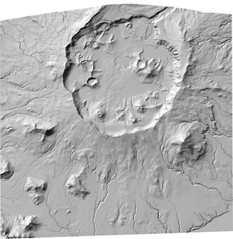
In response to significant morphologic changes in Okmok Caldera due to the phreatomagmatic eruption of Okmok volcano in 2009, a new digital elevation model was acquired to document and quantitatively assess the new volcanic features and altered hydrology within the caldera. This DEM dataset provides elevation data derived from a stereo pair of Worldview-1 satellite images acquired on January 21, 2010. In addition to the DEM, a shaded-relief image is also provided for easy visualization of the data.
This publication, GPR 2015-3, contains geophysical data produced from airborne surveys conducted in 1996 and released in 1997 for 415 sq miles of the Petersville mining district, Alaska by the Alaska Division of Geological & Geophysical Surveys (DGGS). Aeromagnetic and electromagnetic data were acquired during the helicopter-based surveys. During 2004, the same digital data were reformatted for ease of use with modern processing tools, vector files and the 56,000 Hz resistivity grid, were added, and new color maps were produced. Except for leveling of the 56,000 Hz coplanar resistivity grid, no reprocessing of the geophysical data was done. The files represent the end part of the 2004 process. A few maps produced...
In advance of design, permitting, and construction of a pipeline to deliver North Slope natural gas to out-of-state customers and Alaska communities, the Division of Geological & Geophysical Surveys (DGGS) has acquired LiDAR (Light Detection and Ranging) data along proposed pipeline routes, nearby areas of infrastructure, and regions where significant geologic hazards have been identified. LiDAR data will serve multiple purposes, but have primarily been collected to (1) evaluate active faulting, slope instability, thaw settlement, erosion, and other engineering constraints along proposed pipeline routes, and (2) provide a base layer for the state-federal GIS database that will be used to evaluate permit applications...
This digital publication, GPR 2014-2, contains data produced from airborne geophysical surveys conducted in 2012 and 2013 for the Farewell survey area in the McGrath and Yentna mining districts, McGrath and Lime Hills quadrangles, south-central Alaska. Aeromagnetic, electromagnetic (EM), and radiometric data were acquired by helicopter for about 954 sq miles, which includes the 100 sq mile Dalzell Creek area previously released. This publication incorporates data from the previously published Dalzell Creek area into the linedata, grids, maps, and other derivative pieces of this publication. CGG's frequency-domain DIGHEM V system was used for the EM data. GPR 2014-2 includes (1) raw and processed linedata; (2) gridded,...
|

|
