Filters
Date Range
Extensions
Types
Contacts
Categories
Tag Types
Tag Schemes
|
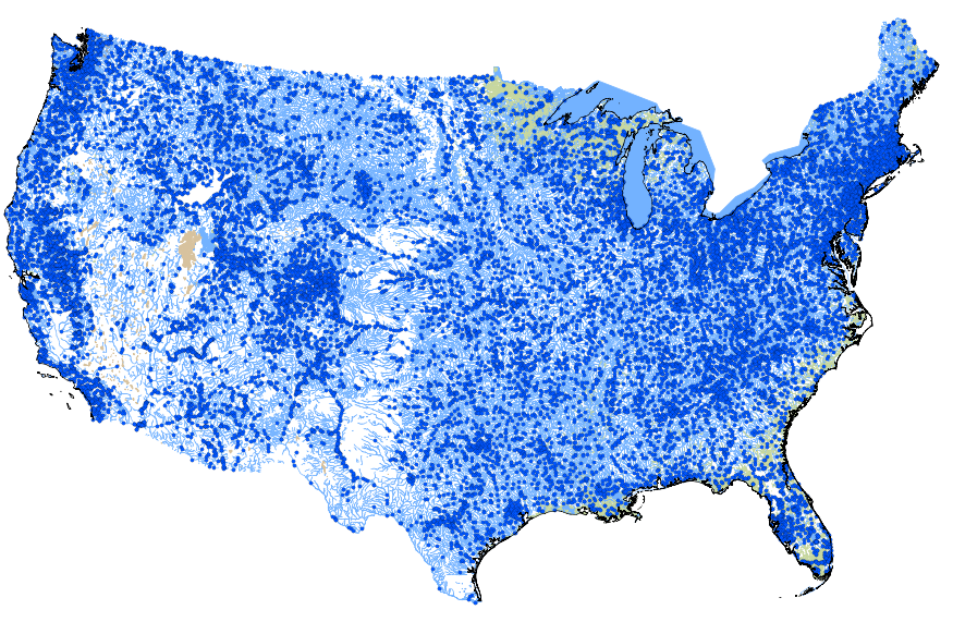
This geodatabase contains streams, waterbodies and wetlands, streamflow gaging stations, and coastlines for the conterminous United States. The streams are incorporated into a geometric network. All feature classes are vertically integrated with each other and with 1:1,000,000-scale transportation and boundary data sets.
Types: Citation;
Tags: Alabama,
Arizona,
Arkansas,
California,
Coastline, All tags...
Colorado,
Connecticut,
Contiguous US,
Contiguous US,
Delaware,
District of Columbia,
Downloadable Data,
Downloadable Data,
Drainage,
FileGDB 10.1,
FileGDB 10.1,
Florida,
Georgia,
Hydrography,
Hydrology,
Idaho,
Illinois,
Indiana,
Iowa,
Kansas,
Kentucky,
Louisiana,
Maine,
Maryland,
Massachusetts,
Michigan,
Minnesota,
Mississippi,
Missouri,
Montana,
National Atlas of the United States,
Nebraska,
Nevada,
New Hampshire,
New Jersey,
New Mexico,
New York,
North Carolina,
North Dakota,
Oceans,
Ohio,
Oklahoma,
Oregon,
Pennsylvania,
Rhode Island,
River,
Shoreline,
Small-scale Datasets,
Small-scale Datasets,
Small-scale Datasets,
Small-scale Datasets - Hydrography,
South Carolina,
South Dakota,
Stream,
Stream Gage,
Stream Gauge,
Streamflow,
Tennessee,
Texas,
US,
USA,
United States,
Utah,
Vermont,
Virginia,
Washington,
Water,
Waterbody,
West Virginia,
Wetland,
Wisconsin,
Wyoming,
inlandWaters,
oceans, Fewer tags

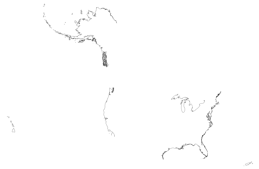
This map layer includes Global Map data showing the coastline of the United States, Puerto Rico, and the U.S. Virgin Islands. The United States shoreline of the Great Lakes is also included. The data are a modified version of the National Atlas of the United States 1:1,000,000-Scale Coastline of the United States.
Types: Citation;
Tags: Alabama,
Alaska,
Arizona,
Arkansas,
California, All tags...
Coastline,
Colorado,
Connecticut,
Delaware,
District of Columbia,
Downloadable Data,
Downloadable Data,
FileGDB 10.1,
FileGDB 10.1,
Florida,
Georgia,
Great Lakes,
Hawaii,
Idaho,
Illinois,
Indiana,
Iowa,
Kansas,
Kentucky,
Louisiana,
Maine,
Maryland,
Massachusetts,
Michigan,
Minnesota,
Mississippi,
Missouri,
Montana,
National,
National,
National Atlas of the United States,
Nebraska,
Nevada,
New Hampshire,
New Jersey,
New Mexico,
New York,
North Carolina,
North Dakota,
Oceans,
Ohio,
Oklahoma,
Oregon,
Pennsylvania,
Puerto Rico,
Rhode Island,
Shoreline,
Small-scale Datasets,
Small-scale Datasets,
Small-scale Datasets,
Small-scale Datasets - Boundaries,
South Carolina,
South Dakota,
Tennessee,
Texas,
U.S. Virgin Islands,
US,
USA,
United States,
Utah,
Vermont,
Virgin Islands,
Virginia,
Washington,
West Virginia,
Wisconsin,
Wyoming,
inlandWaters,
oceans, Fewer tags

This map layer shows Indian lands of the United States. For the most part, only areas of 320 acres or more are included; some smaller areas deemed to be important or significant are also included. Federally-administered lands within a reservation are included for continuity; these may or may not be considered part of the reservation and are simply described with their feature type and the administrating Federal agency. Some established Indian lands which are larger than 320 acres are not included in this map layer because their boundaries were not available from the owning or administering agency.
Tags: Alabama,
Alaska,
Arizona,
Arkansas,
BIA, All tags...
BLM,
BOR,
Bureau of Indian Affairs,
Bureau of Land Management,
Bureau of Reclamation,
California,
Colorado,
Connecticut,
Delaware,
District of Columbia,
Downloadable Data,
Downloadable Data,
FWS,
FileGDB 10.1,
FileGDB 10.1,
Fish and Wildlife Service,
Florida,
Georgia,
Hawaii,
Idaho,
Illinois,
Indian Reservation,
Indian lands,
Indiana,
Iowa,
Kansas,
Kentucky,
Louisiana,
Maine,
Maryland,
Massachusetts,
Michigan,
Minnesota,
Mississippi,
Missouri,
Montana,
NPS,
National,
National,
National Conservation Area,
National Forest,
National Game Preserve,
National Grassland,
National Monument,
National Park,
National Park Service,
National Wilderness Area,
National Wildlife Refuge,
Nebraska,
Nevada,
New Hampshire,
New Jersey,
New Mexico,
New York,
North Carolina,
North Dakota,
Ohio,
Oklahoma,
Oregon,
Pennsylvania,
Public Domain Land,
Rhode Island,
Small-scale Datasets,
Small-scale Datasets,
Small-scale Datasets,
Small-scale Datasets - Boundaries,
South Carolina,
South Dakota,
Tennessee,
Texas,
US,
USA,
United States,
Utah,
Vermont,
Virginia,
Washington,
Waterfowl Production Area,
West Virginia,
Wisconsin,
Wyoming,
boundaries,
society, Fewer tags
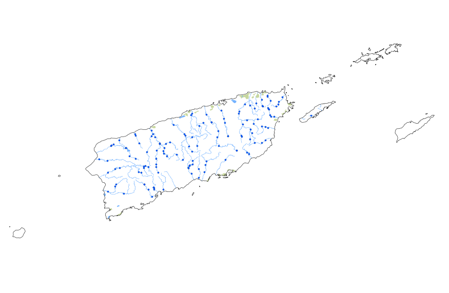
This geodatabase contains streams, waterbodies and wetlands, streamflow gaging stations, and coastlines for Puerto Rico and the U.S. Virgin Islands. The streams are incorporated into a geometric network. All feature classes are vertically integrated with each other and with 1:1,000,000-scale transportation and boundary data sets.
Types: Citation;
Tags: Coastline,
Downloadable Data,
Downloadable Data,
Drainage,
FileGDB 10.1, All tags...
FileGDB 10.1,
Hydrography,
Hydrology,
National Atlas of the United States,
Oceans,
Puerto Rico,
River,
Shoreline,
Small-scale Datasets,
Small-scale Datasets,
Small-scale Datasets,
Small-scale Datasets - Hydrography,
State,
State,
Stream,
Stream Gage,
Stream Gauge,
Streamflow,
U.S. Virgin Islands,
US,
USA,
United States,
Virgin Islands,
Water,
Waterbody,
Wetland,
inlandWaters,
oceans, Fewer tags
This map layer includes Global Map data showing the coastline of the United States, Puerto Rico, and the U.S. Virgin Islands. The United States shoreline of the Great Lakes is also included. The data are a modified version of the National Atlas of the United States 1:1,000,000-Scale Coastline of the United States.
Types: Citation;
Tags: Alabama,
Alaska,
Arizona,
Arkansas,
California, All tags...
Coastline,
Colorado,
Connecticut,
Delaware,
District of Columbia,
Downloadable Data,
Downloadable Data,
Florida,
Georgia,
Great Lakes,
Hawaii,
Idaho,
Illinois,
Indiana,
Iowa,
Kansas,
Kentucky,
Louisiana,
Maine,
Maryland,
Massachusetts,
Michigan,
Minnesota,
Mississippi,
Missouri,
Montana,
National,
National,
National Atlas of the United States,
Nebraska,
Nevada,
New Hampshire,
New Jersey,
New Mexico,
New York,
North Carolina,
North Dakota,
Oceans,
Ohio,
Oklahoma,
Oregon,
Pennsylvania,
Puerto Rico,
Rhode Island,
Shapefile,
Shapefile,
Shoreline,
Small-scale Datasets,
Small-scale Datasets,
Small-scale Datasets,
Small-scale Datasets - Boundaries,
South Carolina,
South Dakota,
Tennessee,
Texas,
U.S. Virgin Islands,
US,
USA,
United States,
Utah,
Vermont,
Virgin Islands,
Virginia,
Washington,
West Virginia,
Wisconsin,
Wyoming,
inlandWaters,
oceans, Fewer tags

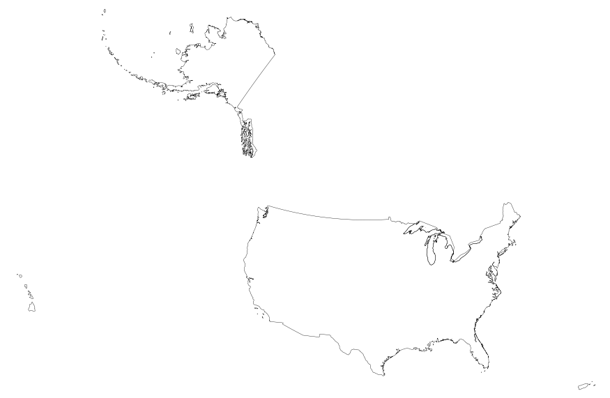
This map layer portrays the coastline of the United States, Puerto Rico, and the U.S. Virgin Islands. The United States shoreline of the Great Lakes is also included. This is a revised version of the July 2012 map layer.
Types: Citation;
Tags: Alabama,
Alaska,
Arizona,
Arkansas,
California, All tags...
Coastline,
Colorado,
Connecticut,
Delaware,
District of Columbia,
Downloadable Data,
Downloadable Data,
FileGDB 10.1,
FileGDB 10.1,
Florida,
Georgia,
Great Lakes,
Hawaii,
Idaho,
Illinois,
Indiana,
Iowa,
Kansas,
Kentucky,
Louisiana,
Maine,
Maryland,
Massachusetts,
Michigan,
Minnesota,
Mississippi,
Missouri,
Montana,
National,
National,
National Atlas of the United States,
Nebraska,
Nevada,
New Hampshire,
New Jersey,
New Mexico,
New York,
North Carolina,
North Dakota,
Oceans,
Ohio,
Oklahoma,
Oregon,
Pennsylvania,
Puerto Rico,
Rhode Island,
Shoreline,
Small-scale Datasets,
Small-scale Datasets,
Small-scale Datasets,
Small-scale Datasets - Boundaries,
South Carolina,
South Dakota,
Tennessee,
Texas,
U.S. Virgin Islands,
US,
USA,
United States,
Utah,
Vermont,
Virgin Islands,
Virginia,
Washington,
West Virginia,
Wisconsin,
Wyoming,
inlandWaters,
oceans, Fewer tags
This map layer portrays the boundaries of the United States, Puerto Rico, and the U.S. Virgin Islands. The map layer was created by extracting county polygon features from the 2006 Census TIGER/Line files produced by the U.S. Census Bureau. These files were then merged into a single file and the county and State boundaries were dissolved, leaving the national boundary. This is a revised version of the July 2012 map layer.
Types: Citation;
Tags: Alabama,
Alaska,
Arizona,
Arkansas,
Boundaries, All tags...
California,
Colorado,
Connecticut,
Delaware,
District of Columbia,
Downloadable Data,
Downloadable Data,
FileGDB 10.1,
FileGDB 10.1,
Florida,
Georgia,
Hawaii,
Idaho,
Illinois,
Indiana,
Iowa,
Kansas,
Kentucky,
Louisiana,
Maine,
Maryland,
Massachusetts,
Michigan,
Minnesota,
Mississippi,
Missouri,
Montana,
National,
National,
National,
National Atlas of the United States,
National boundaries,
Nebraska,
Nevada,
New Hampshire,
New Jersey,
New Mexico,
New York,
North Carolina,
North Dakota,
Ohio,
Oklahoma,
Oregon,
Pennsylvania,
Puerto Rico,
Rhode Island,
Small-scale Datasets,
Small-scale Datasets,
Small-scale Datasets,
Small-scale Datasets - Boundaries,
South Carolina,
South Dakota,
Tennessee,
Texas,
U.S. Virgin Islands,
US,
USA,
United States,
Utah,
Vermont,
Virgin Islands,
Virginia,
Washington,
West Virginia,
Wisconsin,
Wyoming,
boundaries, Fewer tags
|
|

