Filters: Date Range: {"choice":"year"} (X)
2,410,303 results (2.5s)|
Filters
Date Types (for Date Range)
Types
Contacts
Categories Tag Types
|

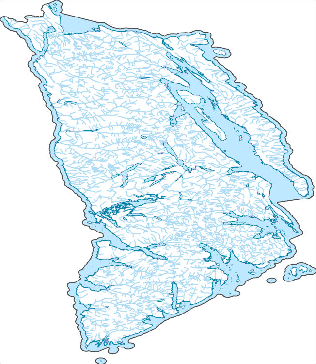
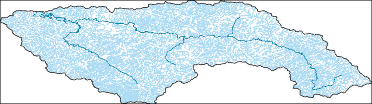
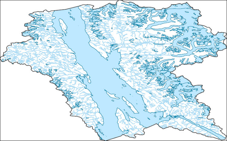
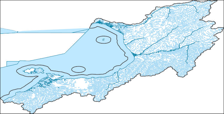
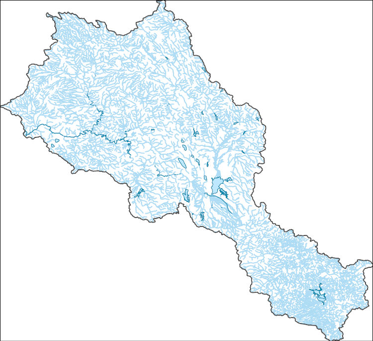
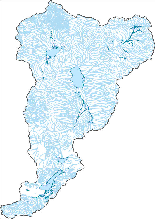
The National Hydrography Dataset (NHD) is a feature-based database that interconnects and uniquely identifies the stream segments or reaches that make up the nation's surface water drainage system. NHD data was originally developed at 1:100,000-scale and exists at that scale for the whole country. This high-resolution NHD, generally developed at 1:24,000/1:12,000 scale, adds detail to the original 1:100,000-scale NHD. (Data for Alaska, Puerto Rico and the Virgin Islands was developed at high-resolution, not 1:100,000 scale.) Local resolution NHD is being developed where partners and data exist. The NHD contains reach codes for networked features, flow direction, names, and centerline representations for areal water...

The National Hydrography Dataset (NHD) is a feature-based database that interconnects and uniquely identifies the stream segments or reaches that make up the nation's surface water drainage system. NHD data was originally developed at 1:100,000-scale and exists at that scale for the whole country. This high-resolution NHD, generally developed at 1:24,000/1:12,000 scale, adds detail to the original 1:100,000-scale NHD. (Data for Alaska, Puerto Rico and the Virgin Islands was developed at high-resolution, not 1:100,000 scale.) Local resolution NHD is being developed where partners and data exist. The NHD contains reach codes for networked features, flow direction, names, and centerline representations for areal water...
This project initiated the first large-scale Tribal government discussions on the relationship of scientific research and traditional knowledge in the activities of the NPLCC. The project: 1. Reviewed existing approaches and protocols related to scientific research and traditional knowledge in the Pacific Northwest, characterized different types of traditional knowledge and the contexts in which these are encountered; 2. Initiated discussions among the 21 member Tribes of the Northwest Indian Fisheries Commission (all other Tribes are welcome to join); 3. Reported on their views; 4. Proposed a framework for the use of TK based on discussions and presented it for a possible consensus by all participants; and 5. Conducted...
Categories: Data,
Project;
Types: Map Service,
OGC WFS Layer,
OGC WMS Layer,
OGC WMS Service;
Tags: 2012,
Academics & scientific researchers,
Decision Support,
Federal resource managers,
Informing Conservation Delivery,
The project had 2 broad objectives. The first objective was to meet the needs of the Yurok Tribe in collecting and documenting TEK to inform tribal planning related to climate change impacts to culturally significant wildlife and habitats that support these species. This information is crucial to informing Yurok Tribe resource managers and the Yurok Council as it embarks on climate change adaptation planning. The Yurok Tribes Council and Environmental, Forestry, Wildlife, Fisheries and Cultural Resources Programs will benefit from the knowledge and wisdom gained from the project as the Tribe prepares for climate change impacts. The second objective was to assist the NPLCC in its efforts to integrate Tribal TEK into...
Categories: Data,
Project;
Types: Map Service,
OGC WFS Layer,
OGC WMS Layer,
OGC WMS Service;
Tags: 2012,
Academics & scientific researchers,
CA-2,
CA-2,
California,
Concerns about the influence of climate change on biota have emerged over the past decade, and responses in species populations and distribution patterns have already been documented (Parmesan 1996, Thomas and Lennon 1999). Current climates and communities will not simply migrate, but rather will re-form in novel ways over time (Fox 2007; Hunter et al. 1988; Williams and Jackson 2007). Due to the uncertainty of future climatic patterns and species responses, enduring features of the landscape (geophysical settings) are appropriate targets of assessment, planning, and conservation (Anderson and Ferree 2010, Beier and Brost 2010, Brost and Beier 2012; Hunter et al. 1988). Only recently have enduring features been...
Categories: Data,
Project;
Types: Map Service,
OGC WFS Layer,
OGC WMS Layer,
OGC WMS Service;
Tags: Climate,
Completed,
Conservation planning,
Consevation design,
Data Acquisition and Development,
A website with links to the Landscape Conservation Cooperative (LCC) Integrated Data Management Network (IDMN) final report as well as individual LCC websites. The IDMN worked with over 20 organizations over two years to bring coherence to the LCC information management landscape. Specifically, the IDMN Network tried to address ways LCC partners implemented the basic building blocks of data management. Issues addressed included building and sharing science products with partners, securely storing those data for the long term, and evaluating ways to get those outputs to cooperators and eventually the public. Over the course of the IDMN project, the scope was expanded to address ways to track projects that produced...
This work provides a flexible and scalable framework to assess the impacts of climate change on streamflow and stream temperature within the North Atlantic Landscape Conservation Cooperative (NALCC) region. This is accomplished through use of lumped parameter, physically-based, conceptual hydrologic and stream temperature models formulated in a hierarchical Bayesian framework. This allows for model predictions of streamflow and temperature at ungaged locations and a formal accounting of model estimate uncertainty at each location, something not previously achieved in these models. These environmental models will also link seamlessly with the land use and fish models. The final products of this project will provide:...
Death Valley National Park, California. Tubular orifices in the fine sediments at Salt Springs near the north side of Borax Camp allow discharge of water to the valley floor. Light areas are accumulations of salts from previous discharges. Circa 1960. Figure 10, U.S. Geological Survey Professional paper 494-B.
Categories: Image;
Types: Map Service,
OGC WFS Layer,
OGC WMS Layer,
OGC WMS Service;
Tags: Death Valley National Park,
Hunt, C.B. Collection,
National Parks,
Photographers,
photo print
This dataset is a file of contour lines representing the estimated altitude of the water table in western Sarpy County. This dataset was developed as part of a cooperative study between the Papillion-Missouri River Natural Resources District (PMRNRD) and USGS which began in 2017. The goal of this study was to develop a hydrogeologic visualization model of western Sarpy County using GeoScene3D. In 2016, the PMRNRD contracted airborne electromagnetic surveys (AEM) of the area to be completed to better understand the stratigraphy and hydrogeology of the western Sarpy County area. The PMRNRD determined that they wanted to incorporate the AEM data into a visualization tool that would allow PMRNRD staff to easily interact...

The National Hydrography Dataset (NHD) is a feature-based database that interconnects and uniquely identifies the stream segments or reaches that make up the nation's surface water drainage system. NHD data was originally developed at 1:100,000-scale and exists at that scale for the whole country. This high-resolution NHD, generally developed at 1:24,000/1:12,000 scale, adds detail to the original 1:100,000-scale NHD. (Data for Alaska, Puerto Rico and the Virgin Islands was developed at high-resolution, not 1:100,000 scale.) Local resolution NHD is being developed where partners and data exist. The NHD contains reach codes for networked features, flow direction, names, and centerline representations for areal water...

The National Hydrography Dataset (NHD) is a feature-based database that interconnects and uniquely identifies the stream segments or reaches that make up the nation's surface water drainage system. NHD data was originally developed at 1:100,000-scale and exists at that scale for the whole country. This high-resolution NHD, generally developed at 1:24,000/1:12,000 scale, adds detail to the original 1:100,000-scale NHD. (Data for Alaska, Puerto Rico and the Virgin Islands was developed at high-resolution, not 1:100,000 scale.) Local resolution NHD is being developed where partners and data exist. The NHD contains reach codes for networked features, flow direction, names, and centerline representations for areal water...

The National Hydrography Dataset (NHD) is a feature-based database that interconnects and uniquely identifies the stream segments or reaches that make up the nation's surface water drainage system. NHD data was originally developed at 1:100,000-scale and exists at that scale for the whole country. This high-resolution NHD, generally developed at 1:24,000/1:12,000 scale, adds detail to the original 1:100,000-scale NHD. (Data for Alaska, Puerto Rico and the Virgin Islands was developed at high-resolution, not 1:100,000 scale.) Local resolution NHD is being developed where partners and data exist. The NHD contains reach codes for networked features, flow direction, names, and centerline representations for areal water...
The National Hydrography Dataset (NHD) is a feature-based database that interconnects and uniquely identifies the stream segments or reaches that make up the nation's surface water drainage system. NHD data was originally developed at 1:100,000-scale and exists at that scale for the whole country. This high-resolution NHD, generally developed at 1:24,000/1:12,000 scale, adds detail to the original 1:100,000-scale NHD. (Data for Alaska, Puerto Rico and the Virgin Islands was developed at high-resolution, not 1:100,000 scale.) Local resolution NHD is being developed where partners and data exist. The NHD contains reach codes for networked features, flow direction, names, and centerline representations for areal water...
Facilitating Adaptation in Montane Plants to Changing Precipitation along an Elevation Gradient Symposium Poster
Categories: Data;
Tags: Document,
LCC Network Science Catalog,
LCC Science Catalog,
Pacific Islands LCC,
completed
The National Hydrography Dataset (NHD) is a feature-based database that interconnects and uniquely identifies the stream segments or reaches that make up the nation's surface water drainage system. NHD data was originally developed at 1:100,000-scale and exists at that scale for the whole country. This high-resolution NHD, generally developed at 1:24,000/1:12,000 scale, adds detail to the original 1:100,000-scale NHD. (Data for Alaska, Puerto Rico and the Virgin Islands was developed at high-resolution, not 1:100,000 scale.) Local resolution NHD is being developed where partners and data exist. The NHD contains reach codes for networked features, flow direction, names, and centerline representations for areal water...
The National Hydrography Dataset (NHD) is a feature-based database that interconnects and uniquely identifies the stream segments or reaches that make up the nation's surface water drainage system. NHD data was originally developed at 1:100,000-scale and exists at that scale for the whole country. This high-resolution NHD, generally developed at 1:24,000/1:12,000 scale, adds detail to the original 1:100,000-scale NHD. (Data for Alaska, Puerto Rico and the Virgin Islands was developed at high-resolution, not 1:100,000 scale.) Local resolution NHD is being developed where partners and data exist. The NHD contains reach codes for networked features, flow direction, names, and centerline representations for areal water...
The National Hydrography Dataset (NHD) is a feature-based database that interconnects and uniquely identifies the stream segments or reaches that make up the nation's surface water drainage system. NHD data was originally developed at 1:100,000-scale and exists at that scale for the whole country. This high-resolution NHD, generally developed at 1:24,000/1:12,000 scale, adds detail to the original 1:100,000-scale NHD. (Data for Alaska, Puerto Rico and the Virgin Islands was developed at high-resolution, not 1:100,000 scale.) Local resolution NHD is being developed where partners and data exist. The NHD contains reach codes for networked features, flow direction, names, and centerline representations for areal water...
The National Hydrography Dataset (NHD) is a feature-based database that interconnects and uniquely identifies the stream segments or reaches that make up the nation's surface water drainage system. NHD data was originally developed at 1:100,000-scale and exists at that scale for the whole country. This high-resolution NHD, generally developed at 1:24,000/1:12,000 scale, adds detail to the original 1:100,000-scale NHD. (Data for Alaska, Puerto Rico and the Virgin Islands was developed at high-resolution, not 1:100,000 scale.) Local resolution NHD is being developed where partners and data exist. The NHD contains reach codes for networked features, flow direction, names, and centerline representations for areal water...
The National Hydrography Dataset (NHD) is a feature-based database that interconnects and uniquely identifies the stream segments or reaches that make up the nation's surface water drainage system. NHD data was originally developed at 1:100,000-scale and exists at that scale for the whole country. This high-resolution NHD, generally developed at 1:24,000/1:12,000 scale, adds detail to the original 1:100,000-scale NHD. (Data for Alaska, Puerto Rico and the Virgin Islands was developed at high-resolution, not 1:100,000 scale.) Local resolution NHD is being developed where partners and data exist. The NHD contains reach codes for networked features, flow direction, names, and centerline representations for areal water...
|

|
