Filters: System Type: Data Release (X) > Categories: NOT Data Release - In Progress (X) > Categories: Data Release - Revised (X)
363 results (50ms)|
Filters
Date Range
Extensions Types
Contacts
Categories Tag Types
|
First Release: Aug 2017 Revised: May 2018 (ver. 1.1) Time-series data of velocity, pressure, turbidity, conductivity, and temperature were collected near the mouth of the Elwha River, Washington, USA, from December 2010 through October 2014, for the Department of Interior’s Elwha River Restoration project. As part of this project, the U.S. Geological Survey studied the effects of renewed sediment supplies on the coastal ecosystems before, during, and following the removal of two dams, Elwha and Glines Canyon, from the Elwha River. Removal of the dams reintroduced sediment stored in the reservoirs to the river, and the river moved much of this sediment to the coast. Several benthic tripods were instrumented with...
Categories: Data,
Data Release - Revised;
Types: Citation;
Tags: CMGP,
CONDUCTIVITY,
CTD,
CTD measurement,
CURRENT METERS,
The Barrier Island Comprehensive Monitoring (BICM) program was developed by Louisiana’s Coastal Protection and Restoration Authority (CPRA) and is implemented as a component of the System Wide Assessment and Monitoring (SWAMP) program. The program uses both historical data and contemporary data collections to assess and monitor changes in the aerial and subaqueous extent of islands, habitat types, sediment texture and geotechnical properties, environmental processes, and vegetation composition. Examples of BICM datasets include still and video aerial photography for documenting shoreline changes, shoreline positions, habitat mapping, land change analyses, light detection and ranging (lidar) surveys for topographic...
Categories: Data Release - Revised;
Tags: Early Lafourche Delta Region,
Gulf of Mexico,
Louisiana,
Louisiana Coastal,
St. Mary Parish,
This data consists of observations of individual trees that were subjected to prescribed fire in western US national parks. Information on individual trees include measurements of tree live/dead status, growth, size, competition, and fire-caused damage. The data also includes estimates of plot-level vapor pressure deficit anomaly before fire. These data support the following publication: van Mantgem, P.J., Falk, D.A., Williams, E.C., Das, A.J., and Stephenson, N.L., 2020, The influence of pre-fire growth on post-fire tree mortality for common conifers in western US parks. International Journal of Wildland Fire. First posted - August 28, 2018 (available from author) Revised - Febuary 10, 2020
The Shasta salamander (Hydromantes shastae) has been petitioned for listing under the Endangered Species Act. The greatest threat to the species is likely habitat loss that will be caused by the increase in elevation of Shasta Lake that will occur with proposed increases in the height of Shasta Dam to increase water storage capacity and maintain cold water for Chinook salmon (Oncorhynchus tshawytscha). Another potential threat is the fungus Batrachochytrium salamandrivorans, which has not yet been detected in North America but is lethal to related salamanders (Hydromantes strinatii) in Europe (Martel et al. 2014). In addition to these threats, recent genetic evidence suggests that the species as originally petitioned...
The U.S. Geological Survey (USGS) worked in cooperation with the Federal Emergency Management Agency (FEMA) to document the October, 2016 storm event in North Carolina. The passage of Hurricane Matthew through central and eastern North Carolina during October 7-9, 2016, brought heavy rainfall which resulted in major flooding. More than 15 inches of rain were recorded in some areas. Over 600 roads were closed including Interstates 95 and 40, and nearly 99,000 structures were impacted by floodwaters. Immediately after the flooding, the USGS documented 267 high-water marks (HWM), of which 254 were surveyed. The North Carolina Emergency Management documented and surveyed 353 HWMs. Using a subset of these HWMs, six flood-inundation...
Categories: Data Release - Revised;
Types: Map Service,
OGC WFS Layer,
OGC WMS Layer,
OGC WMS Service;
Tags: Hurricane Matthew,
North Carolina,
USGS Science Data Catalog (SDC),
Water Resources,
flood,
This dataset is a collection of hyperspectral imagery profiles of 13 common algae associated with Harmful Algae Blooms (HAB). Data were retrieved from a hyperspectral microscope at, and with the cooperation of, the National Institute of Standards and Technology. Samples were collected from USGS water quality sampling efforts, and were also purchased from commercial vendors of biological materials. Data are shown in basic hyperspectral imagery form, transformed into the first derivative and corrected with a flat field algorithm to account for variations in locale lighting conditions. First posted - January 6, 2020 (available from author) Revised - October 30, 2020 (version 2.0)
Categories: Data,
Data Release - Revised;
Tags: Aquatic Biology,
Botany,
Geography,
Harmful Algal Blooms,
Remote Sensing,
Attention: minor changes to the title, citation, and attached files of this data release were made on 2/14/2020. See the attached file 'Revisions_2_14_2020.pdf' for details. Water management and conservation efforts can benefit from scientifically-derived guidelines for the permitting of water withdrawals that maintain the ecological health in streams while simultaneously maximizing water availability for industry, agriculture, drinking water, and waste treatment. Data contained within this data release builds upon the previous framework developed by Knight and others (2008, 2012, 2014, 2016) that established flow-ecology relationships in the Blue Ridge, Ridge and Valley, Interior Plateau, and Cumberland Plateau...
Columns of data representing Chehalis River tributary, sample reach locations, dates of water sampling, quantitative PCR results, and whether lamprey were sampled by electrofishing in each sample reach. ***Please note that the title of this data release used to be "Environmental DNA surveys for lampreys in Chehalis River tributaries, Washington, from 2015 and 2017," but was updated for version 2.0.
Categories: Data,
Data Release - Revised;
Tags: Chehalis River,
USGS Science Data Catalog (SDC),
biota,
environmental DNA,
lampreys
This dataset contains cross-section surveys of the Gunnison River at Colorado Department of Transportation bridges I-04-K and I-03-A, western Colorado, 2016–17. The surveys were performed using a combination of: Trimble R8 Real-Time Kinematic Global Navigation Satellite System (RTK-GNSS) receiver, a USGS bridge crane with sounding weights, and optical levels. During surveys performed in 2016, a base was established at each bridge using the RTK-GNSS equipment. Subsequent surveys of channel geometry were performed using optical levels for ground surface observations above the water line and sounding weights for streambed observations below the water line, referenced to the base established in 2016. Streambed elevations...
Categories: Data,
Data Release - Revised;
Tags: Delta County,
Delta, Colorado,
Grand Junction, Colorado,
Mesa County,
Scour,
The USGS assessment and methodology reports cited within this software release require extensive processing using computational methods and modeling. The most demanding aspects of the modeling were performed using publicly available software: SGeMS and GSLIB (See the 'Related External Resources' section on this webpage to learn more about this software). This publication releases the FORTRAN source code of 15 supplementary computer programs that are required to perform the more specific aspects of the modeling. Upon downloading a program, the user needs to use a FORTRAN compiler for generating the executable code. The tasks performed by these FORTRAN programs are: • blankgridsis, for blanking of several realizations...
Categories: Data Release - Revised,
Software;
Tags: Energy Resources,
USGS Science Data Catalog (SDC),
World,
coal,
software
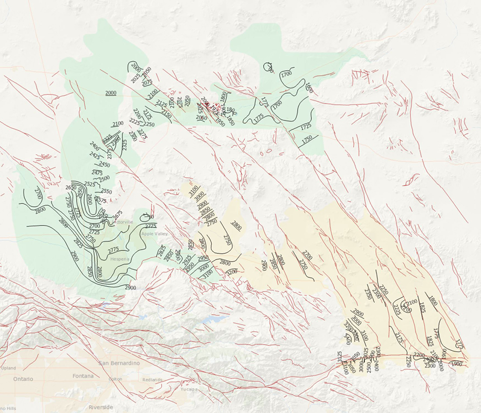
During 2014, the U.S. Geological Survey and other agencies made approximately 1,026 water-level measurements in the Mojave River and Morongo groundwater basins. These data document recent conditions and, when compared with previous data, changes in groundwater levels. A water-level contour map was drawn using data from about 610 wells, providing coverage for most of the basins. Twenty-four hydrographs show long-term (1930-2014) water-level conditions throughout the basins, and 9 short-term (1992 to 2014) hydrographs show the effects of recharge and discharge along the Mojave River. In addition, a water-level-change map was compiled to compare was compiled to compare the 2014 water levels to the 2012 water levels...
Categories: Data Release - Revised;
Tags: USGS,
USGS Science Data Catalog (SDC),
contours,
drainage basin,
ground water,
This data release consists of information from published tables in Connecticut Water Resources Bulletins (WRBs) transcribed into tabular digital format. Information about wells and test holes in the WRBs used in this data release consists of geographic location, depth to consolidated rock (bedrock depth), and depth of the well or test hole. The WRBs, published between 1966 and 1980 by the U.S. Geological Survey (USGS) in cooperation with either the Connecticut Water Resources Commission or the Connecticut Department of Environmental Protection, provided the foundational datasets for companion interpretive USGS Water-Resources Investigation Reports. NOTE: Version 2.0 adds 196 records but is otherwise identical to...
Categories: Data,
Data Release - Revised;
Tags: Connecticut,
USGS Science Data Catalog (SDC),
bedrock surface,
borehole logging,
lithology
Ice breakup dates of Chequamegon Bay, Lake Superior from 1911 to 2022 were compiled by Lori Evrard (USGS, GLSC, Lake Superior Biological Station, Ashland, WI). Ice breakup date is the day in spring when winter ice cover substantially leaves a water body. Local residents deem "ice breakup" as when the ice moves northeast of a line straight across Chequamegon Bay out from Ellis Avenue (State highway 13). Another way ice breakup was determined has been if you could drive a boat from the outlet of Fish Creek to Houghton Point. The ice may move back and forth over that line but the ice is breaking up, moving and melting from that date on. Ellis Avenue ends on a bluff (46.5925 degrees North, 90.8827 degrees West) that...
Categories: Data,
Data Release - Revised;
Tags: Ashland,
Chequamegon Bay,
Climatology,
Great Lakes,
Lake Superior,
This data release includes 40Ar/39Ar data from the U.S. Geological Survey for samples from the Santa Cruz Basin, Arizona. Mineral samples were collected by Kenzie Turner and William Page from the upper Santa Cruz Basin, Arizona. Potassium-bearing mineral grains were separated from the bulk sample and analyzed by argon geochronology at the U.S. Geological Survey Argon Geochronology Laboratory in Denver, Colorado. The data provide age constraints on units in the relevant geologic mapping area.
Categories: Data,
Data Release - Revised;
Types: Downloadable,
Map Service,
OGC WFS Layer,
OGC WMS Layer,
Shapefile;
Tags: 40Ar/39Ar,
Argon Geochronology Laboratory,
Arizona,
GGGSC,
Geochemistry,
Version 3.0 is now available. Please see new data release here: https://doi.org/10.5066/P9AWINWZ. This Data Release contains preliminary versions of two related databases: 1) A fault sections database (“NSHM23_FSD_v2”), which depicts the geometry of faults capable of hosting independent earthquakes, and 2) An earthquake geology site information database (“NSHM23_EQGeoDB_v2”), which contains fault slip-rate constraints at points. These databases were prepared in anticipation of updates to the National Seismic Hazard Model (NSHM) 2023. Fault-specific geologic parameters for the NSHM have not been updated since the 2014 NSHM release. The datasets include the states of Washington, Oregon, California, Idaho, Nevada,...
Categories: Data,
Data Release - Revised;
Tags: Arizona,
California,
Colorado,
Geomorphology,
Idaho,
The dataset is composed of three data tables containing information from electrofishing and pebble count surveys conducted in tributaries to the Mohawk River in central and eastern New York during 2019. The first table contains information on the sampled reaches, the second table contains fish collection data, and the third table contains pebble count data.
Categories: Data,
Data Release - Revised;
Types: ArcGIS REST Map Service,
Map Service;
Tags: Ambient Monitoring,
Aquatic Biology,
Aquatic Community Health,
Ecosystem Health,
Mohawk River,
This dataset presents water withdrawal estimates, consumption estimates, and associated information for 1,122 water-using, utility scale thermoelectric power plants in the United States for 2015. The U.S. Geological Survey (USGS) developed models to estimate thermoelectric water use based on linked heat-and-water budgets, including thermodynamically plausible ranges of minimum and maximum withdrawal and consumption, to provide a consistent method for water-use estimation across the fleet of U.S. thermoelectric plants. Historically, thermoelectric water withdrawal and consumption has been estimated by the Department of Energy's Energy Information Administration (EIA) based on surveys of plant operator-reported data...
Categories: Data,
Data Release - Revised;
Types: Map Service,
OGC WFS Layer,
OGC WMS Layer,
OGC WMS Service;
Tags: Energy Resources,
USGS Science Data Catalog (SDC),
Water Resources,
consumptive water use,
groundwater,
This data release has been superseded by version 3.0, available here: https://doi.org/10.5066/P9MJVQSQ Quantifying Western U.S. shrublands as a series of fractional components with remote sensing provides a new way to understand these changing ecosystems. The USGS NLCD team in collaboration with the BLM has produced the most comprehensive remote sensing-based quantification of Western U.S. shrublands to date. Nine shrubland ecosystem components, including percent shrub, sagebrush (Artemisia spp.), big sagebrush, herbaceous, annual herbaceous, litter, and bare ground cover, along with sagebrush and shrub heights, were quantified at 30-m resolution by mapping region. Each region required extensive ground measurement...
Categories: Data Release - Revised;
Tags: AZ,
Arizona,
Arizona Plateau,
Black Hills,
Blue Mountains,
This data release contains several datasets that provide an overview of oil and gas well history and production of the United States, from 1817 to September 1, 2022. Well history data is aggregated into 1-mile and 10-mile squares indicating the total number of wells and counts of wells classified as oil, gas, dry, injection, hydraulically fractured, and/or horizontal wells. Well history is also separated into layers binned on 1-year increments from a well's spud date (date drilling commenced). Production data is aggregated in 2-mile and 10-mile squares that sum the total production of oil, gas, and water volumes. Production data is also separated into layers binned on 1-year increments to reflect the year of production....
Categories: Data Release - Revised;
Tags: North America,
USGS Science Data Catalog (SDC),
United States,
energy resources,
location,
This data release includes concentrations of 24 per- and polyfluoroalkyl substances (PFAS) and physical properties of water-quality samples collected by the U.S. Geological Survey (USGS) at 64 selected sites in rivers and streams in Massachusetts over three rounds of sampling. The samples were collected from August to November 2020 when streamflow conditions were below normal (also considered to be base-flow conditions) at rivers and streams in urban areas that receive treated wastewater from municipal wastewater-treatment facilities, and in rural rivers and streams that are not associated with municipal wastewater discharges and may have other source inputs of PFAS. The measured physical properties include water...
Categories: Data Release - Revised;
Types: Map Service,
OGC WFS Layer,
OGC WMS Layer,
OGC WMS Service;
Tags: Assabet River,
Blackstone River,
Charles River,
Chicopee River,
Cold River,
|

|
