Filters: Tags: {"scheme":"Data Basin"} (X)
9,686 results (24ms)|
Filters
Date Range
Contacts (Less)
Tags (with Scheme=Data Basin)
|
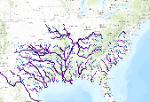
Ecologically relevant river size classes for NHDPlus v1 flowlines in the 14 state SARP region. Size class was determined for each river flowline using the cumulative drainage area from NHDPlus v1 dataset. The data are scaled to show the largest rivers at the regional scale. Zoom into the map for smaller rivers, creeks, and headwaters. For more information about how this attribute was developed by the Southern Instream Flow Network (SIFN), go to http://www.southeastaquatics.net/sarps-programs/sifn/instream-flow-resourcesYour comments about this dataset are welcome. Please send comments to the dataset author using the Comment tab below.Â
These maps are a digital representation of the individual tree species range maps of the Atlas of the United States Trees by Elbert L. Little, Jr. The atlas shows the natural distribution or range of the native tree species of North America. These coverages represent 3 volumes of the atlas. Little's tree extent maps can be found in the Data Basin gallery here: http://app.databasin.org/app/pages/galleryPage.jsp?id=5e449f3c91304f498a96299a9d5460a3

MooseConcentrationArea is an ESRI SDE Feature Class showing that part of the range of a species where densities are 200% higher than the surrounding area during a specific season. This information was derived from field personnel. A variety of data capture techniques were used including drawing on mylar overlays at 1:50,000 scale USGS county mapsheets and implementation of the SmartBoard Interactive Whiteboard using stand-up, real-time digitizing at various scales (Cowardin, M., M. Flenner. March 2003. Maximizing Mapping Resources. GeoWorld 16(3):32-35). Dataset was acquired from a third party distributor who obtained it from CDOW in January 2011. The authoritative data source is available on ArcGIS.com (http://www.arcgis.com/home/item.html?id=1245503b755346989c938aa250c23648)...

This dataset depicts Wolf (Canis lupus) habitat in the Northern Appalachians predicted using the spatially explicit population model PATCH under the current habitat effectiveness plus low US mortality plus moderate Canadian mortality scenario (Carroll 2003). This dataset represents one of several scenarios testing the effects of habitat effectiveness and mortality rates on wolf populations. Static habitat suitability models for wolf were fed through PATCH to predict source and sink habitat areas across the landscape. The static models for wolf were created based on current and projected habitat effectiveness, which were based in part on road density and human population density. Wolf fecundity rates were based on...

The integrity of Amazon forests are currently threatened by climate change, deforestation, and fire. However, it is unclear how these agents of change interact over large spatial and temporal domains and reducing this uncertainty is important for projecting changes in carbon stocks and species biogeography, and could better inform continental scale conservation programs. With this in mind, aboveground biomass and tree cover data were produced using the dynamic global vegetation model, LPJmL, with 9 different global climate models (using the SRES A2 emissions storyline) and 2 different deforestation scenarios (from Soares et al.). The existing fire module was modified to include 'escaped fire' associated with deforestation,...
These maps are a digital representation of the individual tree species range maps of the Atlas of the United States Trees by Elbert L. Little, Jr. The atlas shows the natural distribution or range of the native tree species of North America. These coverages represent 3 volumes of the atlas. Little's tree extent maps can be found in the Data Basin gallery here: http://app.databasin.org/app/pages/galleryPage.jsp?id=5e449f3c91304f498a96299a9d5460a3

These maps are a digital representation of the individual tree species range maps of the Atlas of the United States Trees by Elbert L. Little, Jr. The atlas shows the natural distribution or range of the native tree species of North America. These coverages represent 3 volumes of the atlas. Little's tree extent maps can be found in the Data Basin gallery here: http://app.databasin.org/app/pages/galleryPage.jsp?id=5e449f3c91304f498a96299a9d5460a3

This dataset is a Basin Characterization Model (BCM) output using the PCM A2 Scenario for annual recharge, 2010-2039, clipped to the DRECP 12 km buffered boundary. Recharge: Amount of water exceeding field capacity that enters bedrock, occurs at a rate determined by the hydraulic conductivity of the underlying materials, excess water (rejected recharge) is added to runoff. The California Basin Characterization Model (BCM) climate dataset provides historical and projected climate surfaces for the state at a 270 meter resolution. The historical data is based on 4 kilometer PRISM data, and the projected climate surfaces are based on the A2 and B1 scenarios of the PCM and GFDL GCMs. The BCM approach uses a regional...

The integrity of Amazon forests are currently threatened by climate change, deforestation, and fire. However, it is unclear how these agents of change interact over large spatial and temporal domains and reducing this uncertainty is important for projecting changes in carbon stocks and species biogeography, and could better inform continental scale conservation programs. With this in mind, aboveground biomass and tree cover data were produced using the dynamic global vegetation model, LPJmL, with 9 different global climate models (using the SRES A2 emissions storyline) and 2 different deforestation scenarios (from Soares et al.). The existing fire module was modified to include 'escaped fire' associated with deforestation,...

This dataset represents actual and predicted suitable habitat for Liriodendron tuliperfia (yellow-poplar, species code 621) in the Eastern United States as measured by importance value based on data obtained from the Forest Inventory and Analysis (FIA) project, current climate conditions, and future climate projections. This summary unit of this dataset is a 20 by 20 kilometer cell. The actual importance value (IV) was calculated based on the number of stems and basal area of a given tree species relative to other tree species on a plot using about 100,000 FIA plots (representing nearly 3 million tree records) in the 37 states within the United States east of the 100th meridian. These importance values were summarized...

The Standardized Precipitation Index (SPI) is a probability index that can be calculated for different time periods to indicate periods of abnormal wetness or dryness. SPI is derived solely from monthly precipitation and can be compared across regions with different climates. The SPI is an index based on the probability of recording a given amount of precipitation, and the probabilities are standardized so that an index of zero indicates the median precipitation amount (half of the historical precipitation amounts are below the median, and half are above the median). This dataset shows the average 12-month SPI (in classes ranging from extremely wet to extremely dry) for the three-month forecast period indentified...

Pacific-slope Flycatcher station lifetime productivity (STAPI) (log transformed) ranged between -0.034 and +0.606 with a mean value of +0.286 and a median value of +0.247. ________________________________________ Model 1 (3 parameters) Pacific-slope Flycatcher station lifetime productivity (STAPI) (log transformed) was a function of: a) INTERCEPT (0.3022), b) NLCD06AF90P (+0.01874) - percent all forest cover, 90m-resolution(3x aggregation of 30m-resolution), ranged between -1.901 and +6.011 (95% CL) with a mean value of +2.055 and a median value of +2.494, c) NLCD06IM33P (-0.02730) - percent impervious cover, 990m-resolution (33x aggregation of 30m-resolution), ranged between -1.057 and +5.084 (95% CL) with...

MC1 is a dynamic vegetation model for estimating the distribution of vegetation and associated ecosystem fluxes of carbon, nutrients, and water. It was created to assess the potential impacts of global climate change on ecosystem structure and function at a wide range of spatial scales from landscape to global. The model incorporates transient dynamics to make predictions about the patterns of ecological change. MC1 was created by combining physiologically based biogeographic rules defined in the MAPSS model with a modified version of the biogeochemical model, CENTURY. MC1 includes a fire module, MCFIRE, that mechanistically simulates the occurrence and impacts of fire events. Climate input data sources for this...

Protected areas are cornerstones of national and international conservation strategies. By way of these designations, lands and waters are set-aside in-perpetuity to preserve functioning natural ecosystems, act as refuges for species, and maintain ecological processes. Complementary conservation strategies preserve land for the sustainable use of natural resources, or for the protection of significant geologic and cultural features or open space. PAD-US 1.1 (CBI Edition) attempts to include all available spatial data on these places. It is our goal to publish the most comprehensive geospatial data set of U. S. protected areas to date. PAD-US 1.1 (CBI Edition) is limited to the continental U.S., Alaska, and Hawaii....

Protected areas are cornerstones of national and international conservation strategies. By way of these designations, lands and waters are set-aside in-perpetuity to preserve functioning natural ecosystems, act as refuges for species, and maintain ecological processes. Complementary conservation strategies preserve land for the sustainable use of natural resources, or for the protection of significant geologic and cultural features or open space. PAD-US 1.1 (CBI Edition) attempts to include all available spatial data on these places. It is our goal to publish the most comprehensive geospatial data set of U. S. protected areas to date. PAD-US 1.1 (CBI Edition) is limited to the continental U.S., Alaska, and Hawaii....

The integrity of Amazon forests are currently threatened by climate change, deforestation, and fire. However, it is unclear how these agents of change interact over large spatial and temporal domains and reducing this uncertainty is important for projecting changes in carbon stocks and species biogeography, and could better inform continental scale conservation programs. With this in mind, above ground biomass and tree cover data were produced using the dynamic global vegetation model, LPJmL, with 9 different global climate models (using the SRES A2 emissions storyline) and 2 different deforestation scenarios (from Soares et al.). The existing fire module was modified to include 'escaped fire' associated with deforestation,...

The integrity of Amazon forests are currently threatened by climate change, deforestation, and fire. However, it is unclear how these agents of change interact over large spatial and temporal domains and reducing this uncertainty is important for projecting changes in carbon stocks and species biogeography, and could better inform continental scale conservation programs. With this in mind, above ground biomass and tree cover data were produced using the dynamic global vegetation model, LPJmL, with 9 different global climate models (using the SRES A2 emissions storyline) and 2 different deforestation scenarios (from Soares et al.). The existing fire module was modified to include 'escaped fire' associated with deforestation,...

The integrity of Amazon forests are currently threatened by climate change, deforestation, and fire. However, it is unclear how these agents of change interact over large spatial and temporal domains and reducing this uncertainty is important for projecting changes in carbon stocks and species biogeography, and could better inform continental scale conservation programs. With this in mind, above ground biomass and tree cover data were produced using the dynamic global vegetation model, LPJmL, with 9 different global climate models (using the SRES A2 emissions storyline) and 2 different deforestation scenarios (from Soares et al.). The existing fire module was modified to include 'escaped fire' associated with deforestation,...

Zone 24 (covering small portions of Michigan and New York) of the contiguous U.S. percent developed imperviousness dataset from NLCD 2006, released 2/16/2011. The full dataset is divided into 25 zones, which can all be found in the NLCD 2006 gallery. The National Land Cover Database products are created through a cooperative project conducted by the Multi-Resolution Land Characteristics (MRLC) Consortium. The MRLC Consortium is a partnership of federal agencies (www.mrlc.gov), consisting of the U.S. Geological Survey (USGS), the National Oceanic and Atmospheric Administration (NOAA), the U.S. Environmental Protection Agency (EPA), the U.S. Department of Agriculture (USDA), the U.S. Forest Service (USFS), the...

Zone 23 (covering parts of Minnesota, Wisconsin, and Michigan) of the contiguous U.S. percent developed imperviousness dataset from NLCD 2006, released 2/16/2011. The full dataset is divided into 25 zones, which can all be found in the NLCD 2006 gallery. The National Land Cover Database products are created through a cooperative project conducted by the Multi-Resolution Land Characteristics (MRLC) Consortium. The MRLC Consortium is a partnership of federal agencies (www.mrlc.gov), consisting of the U.S. Geological Survey (USGS), the National Oceanic and Atmospheric Administration (NOAA), the U.S. Environmental Protection Agency (EPA), the U.S. Department of Agriculture (USDA), the U.S. Forest Service (USFS),...
|

|
