Filters
Date Range
Extensions
(Less)
Types
(Less)
Contacts
(Less)
Tag Types
Tags (with Scheme=NGDA Portfolio Themes)
|
As one of the cornerstones of the U.S. Geological Survey's (USGS) National Geospatial Program, The National Map is a collaborative effort among the USGS and other Federal, State, and local partners to improve and deliver topographic information for the Nation. It has many uses ranging from recreation to scientific analysis to emergency response. The National Map is easily accessible for display on the Web, as products and services, and as downloadable data. The geographic information available from The National Map includes orthoimagery (aerial photographs), elevation, geographic names, hydrography, boundaries, transportation, structures, and land cover.
Tags: 1 arc-second DEM,
1 meter DEM,
1-degree DEM,
1/3 arc-second DEM,
1/9 arc-second DEM, All tags...
10,000 meter DEM,
15-minute DEM,
2 arc-second DEM,
3DEP,
Administrative watershed units,
Aerial Compliance,
Aerial Photography,
Agricultural land,
Airport Complex,
Airport Point,
Airport Runway,
Airports,
Airstrips,
Area of Complex Channels,
Area to be submerged,
Bare Earth,
Barren land,
Basin,
Bay/Inlet,
Boundaries,
Boundary,
Bridge,
Canal/Ditch,
Cartography,
Coastline,
College / University,
Compliance,
Connector,
County or Equivalent,
DEM,
Dam/Weir,
Digital Elevation Model,
Digital Mapping,
Digital Ortho rectified Image,
Digital Terrain Model,
Drainage areas for surface water,
Elevation,
Elevation Theme,
Estuary,
Feature class,
Feature coordinates,
Feature county,
Feature description,
Feature designation,
Feature history,
Feature identification,
Feature name,
Feature state,
Fire Station/ EMS Station,
Flow direction network,
Flume,
ForeShore,
Forest land,
GIS,
Gaging Station,
Gate,
Geodata,
Geographic feature,
Geographic name,
Geographic names,
Geographical feature,
Geographical name,
Georeferenced,
Governmental Units, and Administrative and Statistical Boundaries Theme,
Grid,
HU10,
HU12,
HU14,
HU16,
HU2,
HU4,
HU6,
HU8,
HUC,
Hazard Zone,
High Resolution,
High Resolution Orthoimagery,
Hospital/Medical Center,
Hydro-Flattened,
Hydrographic,
Hydrography,
Hydrologic Unit Code,
Hydrologic Units,
IFSAR,
Ice mass,
Image processing,
Impervious,
Imperviousness,
Incorporated Place,
Interferometric Synthetic Aperture Radar,
Inundation Area,
JPEG 2000,
Juction,
Jurisdictional,
LAS,
LIDAR,
LIght Detection And Ranging,
Land Use-Land Cover Theme,
Land cover,
Law Enforcement,
Levee,
Light Detection and Ranging,
Line,
Lock Chamber,
Mapping,
Marsh,
Minor Civil Division,
NAIP,
NED,
NGDA,
National Elevation Dataset,
National Geospatial Data Asset,
Native American Area,
NavAid,
Nonearthen Shore,
Not Classified,
Official feature name,
Ortho Rectification,
Orthoimage,
PLSS First Division,
PLSS Special Survey,
PLSS Township,
Percent Developed Imperviousness,
Place name,
Playa,
Point,
Point Cloud,
PointEvent,
Pond,
Prison/ Correctional Facility,
Public Land Survey System,
Quarter Quadrangle,
Railways,
Range land,
Rapids,
Raster,
Reach,
Reach code,
Real Property Theme,
Reef,
Region,
Reserve,
Reservoir,
Roads,
Rock,
School,
School:Elementary,
School:High School,
School:Middle School,
Sea/Ocean,
Sink/Rise,
Sounding Datum Line,
Special Use Zone,
Special Use Zone Limit,
Spillway,
State Capitol,
State or Territory,
Stream/River,
Sub-basin,
Sub-region,
Subbasin,
Submerged Stream,
Subregion,
Subwatershed,
Survey,
Swamp,
Technical School,
Terrain Elevation,
Topographic,
Topographic Surface,
Topography,
Trade School,
TrailFeature,
Trails,
Transportation,
Transportation Theme,
Tunnel,
U.S. Geological Survey,
U.S. Geological Survey (USGS),
U.S. National Grid,
USGS,
Underground Conduit,
Unincorporated Place,
Urban and built-up land,
Variant name,
Vector,
WBD,
Wall,
Wash,
Water,
Water Intake Outflow,
Water – Inland Theme,
Waterfall,
Watershed,
Watershed Boundaries,
Watershed Boundary Dataset,
Waterway,
Well,
Wetland,
Woodland,
a-16,
altitude,
annotations,
artificial path,
biota,
boundaries,
boundaries,
boundary,
cadastral surveys,
contour,
dams,
dems,
digital spatial data,
drainage systems and characteristics,
ecology,
economy,
elevation,
elevation,
environment,
flora,
geographic names,
grid,
habitat,
hydrography,
image map,
imagery,
imageryBaseMapsEarthCover,
inlandWaters,
lakes,
land cover,
land ownership,
land use maps,
legal land descriptions,
location,
natural color orthophoto,
orthoimage,
orthophoto,
political and administrative boundaries,
polygon grid,
rectified image,
rivers,
slope,
society,
stream,
structure,
transportation, Fewer tags
USGS Structures from The National Map (TNM) consists of data to include the name, function, location, and other core information and characteristics of selected manmade facilities across all US states and territories. The types of structures collected are largely determined by the needs of disaster planning and emergency response, and homeland security organizations. Structures currently included are: School, School:Elementary, School:Middle, School:High, College/University, Technical/Trade School, Ambulance Service, Fire Station/EMS Station, Law Enforcement, Prison/Correctional Facility, Post Office, Hospital/Medical Center, Cabin, Campground, Cemetery, Historic Site/Point of Interest, Picnic Area, Trailhead, Vistor/Information...
Types: Citation;
Tags: Ambulance Service,
Cabin,
Campground,
Cemetery,
City / Town Hall, All tags...
College / University,
Court House,
Fire Station / EMS Station,
Headquarters,
Historic Site / Point of Interest,
Hospital / Medical Center,
Law Enforcement,
NGDA,
NGDAID135,
National Geospatial Data Asset,
National Structures Dataset (NSD),
Picnic Area,
Post Office,
Prison / Correctional Facility,
Ranger Station,
Real Property Theme,
School,
School: Elementary,
School: High School,
School: Middle School,
State Capitol,
State Supreme Court,
Technical / Trade School,
Trailhead,
US,
US Capitol,
US Supreme Court,
USGS:db4fb1b6-1282-4e5b-9866-87a68912c5d1,
United States,
Visitor / Information Center,
White House,
structure, Fewer tags
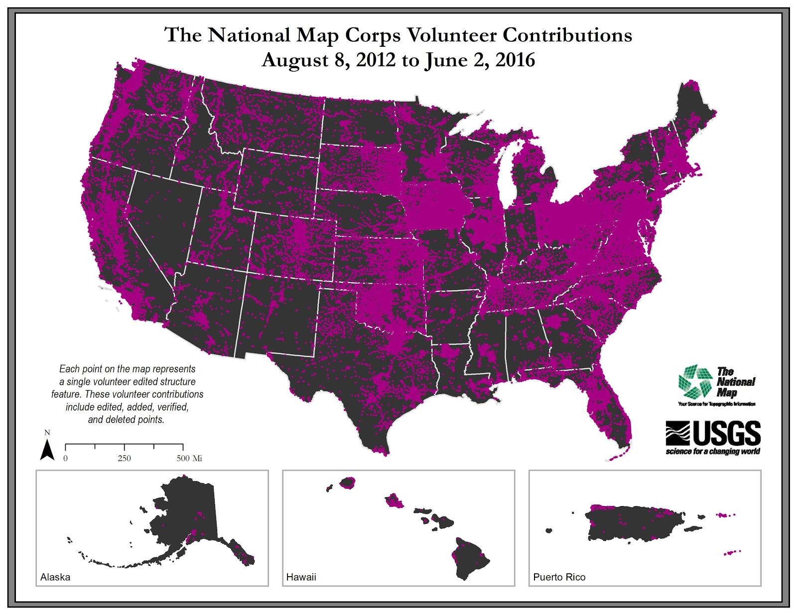
U.S. Geological Survey, Department of the Interior - The annual National Map Corps Volunteered Geographic Information (VGI) structures acquisition plan is to add new structures data and remove or edit obsolete structures data points over the United States. The FY17 acquisition plan allows data contributions by volunteers for all 50 states. Interested parties who wish to become a volunteer data acquisition partner with the USGS in FY17 or in future years should contact a USGS Geospatial Liaison - http://liaisons.usgs.gov/geospatial/documents/TNM_Partnership_User_ContactList.pdf. To find out more about the National Map Corps VGI structures program go to https://my.usgs.gov/confluence/display/nationalmapcorps/Home.
Types: Citation;
Tags: EMS station,
NGDA,
National Geospatial Data Asset,
Real Property Theme,
Structures, All tags...
TNMCorps,
The National Map Corps,
VGI,
acquisition plan,
ambulance service,
cemetery,
college,
crowdsourcing,
fire station,
geographic,
hospital,
information,
law enforcement,
mapping,
police station,
post office,
prison,
school,
state capitol,
structure,
structure,
university,
volunteer,
volunteered, Fewer tags
|
|

