Filters: Tags: {"scheme":"The National Map Theme Thesaurus","name":"elevation"} (X) > partyWithName: U.S. Geological Survey, National Geospatial Technical Operations Center (X) > Types: Citation (X)
22 results (129ms)|
Filters
Date Range
Extensions Types Contacts
Categories Tag Types Tags (with Scheme=The National Map Theme Thesaurus) |

These vector contour lines are derived from the 3D Elevation Program using automated and semi-automated processes. They were created to support 1:24,000-scale topographic map products, but are also published in this GIS vector format. Contour intervals are assigned by 7.5-minute quadrangle, so this vector dataset is not visually seamless across quadrangle boundaries. The vector lines have elevation attributes (in feet above mean sea level on NAVD88), but this dataset does not carry line symbols or annotation.

These vector contour lines are derived from the 3D Elevation Program using automated and semi-automated processes. They were created to support 1:24,000-scale topographic map products, but are also published in this GIS vector format. Contour intervals are assigned by 7.5-minute quadrangle, so this vector dataset is not visually seamless across quadrangle boundaries. The vector lines have elevation attributes (in feet above mean sea level on NAVD88), but this dataset does not carry line symbols or annotation.
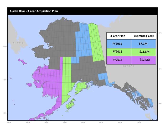
U.S. Geological Survey, Department of the Interior - The annual Alaska IfSAR and DEM acquisition plan is part of the 3DEP initiative to collect high-quality elevation data in the form of interferometric synthetic aperture radar (IfSAR) and light detection and ranging (lidar) data over Alaska. This acquisition plan addresses concerns raised in GAO Report 13-94 regarding geospatial coordination, and supports FGDC data coordination initiatives led by the Department of Interior's Geospatial Information Officer. Mapping a State the size and complexity of Alaska through a partnered effort such as the Alaska Mapping Initiative requires dedicated collaboration and coordination across multiple levels of government. State...

These vector contour lines are derived from the 3D Elevation Program using automated and semi-automated processes. They were created to support 1:24,000-scale topographic map products, but are also published in this GIS vector format. Contour intervals are assigned by 7.5-minute quadrangle, so this vector dataset is not visually seamless across quadrangle boundaries. The vector lines have elevation attributes (in feet above mean sea level on NAVD88), but this dataset does not carry line symbols or annotation.
Types: Citation;
Tags: 1 x 1 degree,
Downloadable Data,
Elevation,
Elevation Terrestrial,
FileGDB 10.1,
U.S. Geological Survey, Department of the Interior - The annual lidar and DEM acquisition plan is part of the 3DEP initiative to systematically collect enhanced elevation data (Quality Level 2) in the form of high-quality light detection and ranging (lidar) data over the conterminous United States, Hawaii, and the territories on an 8-year schedule. The FY17 acquisition plan currently anticipates collecting 225,000 sq. mi. or more depending on partnerships and other contributions to the plan. Interested parties who wish to become a funding partner with the USGS in FY17 or in future years should contact a USGS Geospatial Liaison - http://liaisons.usgs.gov/geospatial/documents/TNM_Partnership_User_ContactList.pdf....
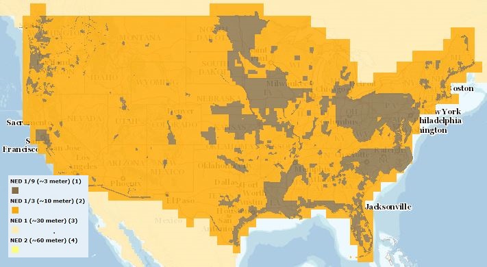
The USGS Elevation Availability service from The National Map (TNM) shows the best available resolution of downloadable elevation data, and is updated approximately every two weeks with National Elevation Dataset (NED) releases. NED 2- (in Alaska only), 1-, and 1/3-arc-second data are staged for download by 1x1 degree tiles in ArcGrid, GridFloat, or IMG formats in The National Map viewer, while NED 1/9 arc-second data is staged by 15x15 minute tiles in IMG format only. For additional information on the NED, go to http://ned.usgs.gov/.

These vector contour lines are derived from the 3D Elevation Program using automated and semi-automated processes. They were created to support 1:24,000-scale topographic map products, but are also published in this GIS vector format. Contour intervals are assigned by 7.5-minute quadrangle, so this vector dataset is not visually seamless across quadrangle boundaries. The vector lines have elevation attributes (in feet above mean sea level on NAVD88), but this dataset does not carry line symbols or annotation.

These vector contour lines are derived from the 3D Elevation Program using automated and semi-automated processes. They were created to support 1:24,000-scale topographic map products, but are also published in this GIS vector format. Contour intervals are assigned by 7.5-minute quadrangle, so this vector dataset is not visually seamless across quadrangle boundaries. The vector lines have elevation attributes (in feet above mean sea level on NAVD88), but this dataset does not carry line symbols or annotation.

These vector contour lines are derived from the 3D Elevation Program using automated and semi-automated processes. They were created to support 1:24,000-scale topographic map products, but are also published in this GIS vector format. Contour intervals are assigned by 7.5-minute quadrangle, so this vector dataset is not visually seamless across quadrangle boundaries. The vector lines have elevation attributes (in feet above mean sea level on NAVD88), but this dataset does not carry line symbols or annotation.

These vector contour lines are derived from the 3D Elevation Program using automated and semi-automated processes. They were created to support 1:24,000-scale topographic map products, but are also published in this GIS vector format. Contour intervals are assigned by 7.5-minute quadrangle, so this vector dataset is not visually seamless across quadrangle boundaries. The vector lines have elevation attributes (in feet above mean sea level on NAVD88), but this dataset does not carry line symbols or annotation.
Types: Citation;
Tags: 1 x 1 degree,
Clackamas County,
Clark County,
Columbia County,
Cowlitz County,

USGS Hill Shade (or Shaded Relief) is a tile cache base map created from the National Elevation Dataset (NED), a seamless dataset of best available raster elevation data for the conterminous United States, Alaska, Hawaii, and Territorial Islands. Derived from the NED using a hill shade technique, this base map represents a continental view showing shaded relief from USGS NED layers at resolutions of 1/3-, 1-, and 2-arc-second (in Alaska only). Shaded relief (or hill shade) function parameters are: point illumination is from the NW (azimuth = 315 degrees), and altitude of the light source is 45 degrees. Color characteristics are the result of applying a color ramp in which RGB values range from white (RGB: 255, 255,...
Types: Citation;
Tags: Base Map Service,
Elevation,
Elevation Theme,
NGDA,
National Geospatial Data Asset,

The geospatial data of this layer is comprised of elevation contours.
Types: Citation;
Tags: 1 x 1 degree,
Downloadable Data,
EarthCover,
Elevation,
Imagery and Base Maps,

These vector contour lines are derived from the 3D Elevation Program using automated and semi-automated processes. They were created to support 1:24,000-scale topographic map products, but are also published in this GIS vector format. Contour intervals are assigned by 7.5-minute quadrangle, so this vector dataset is not visually seamless across quadrangle boundaries. The vector lines have elevation attributes (in feet above mean sea level on NAVD88), but this dataset does not carry line symbols or annotation.
Types: Citation;
Tags: 1 x 1 degree,
Downloadable Data,
Elevation,
Elevation Terrestrial,
FileGDB 10.1,

The USGS Elevation Availability service from The National Map (TNM) shows the best available resolution of downloadable elevation data, and is updated approximately every weeks with 3D Elevation Program (3DEP) releases. Alaska 2 arc-second, 1 arc-second, and 1/3-arc-second data are staged for download by 1x1 degree tiles in ArcGrid, GridFloat, or IMG formats in The National Map viewer, while 1/9 arc-second data is staged by 15x15 minute tiles in IMG format only. For additional information on the 3D Elevation Program (3DEP), go to https://nationalmap.gov/3DEP/.

These vector contour lines are derived from the 3D Elevation Program using automated and semi-automated processes. They were created to support 1:24,000-scale topographic map products, but are also published in this GIS vector format. Contour intervals are assigned by 7.5-minute quadrangle, so this vector dataset is not visually seamless across quadrangle boundaries. The vector lines have elevation attributes (in feet above mean sea level on NAVD88), but this dataset does not carry line symbols or annotation.
Types: Citation;
Tags: 1 x 1 degree,
Downloadable Data,
Elevation,
Elevation Terrestrial,
FileGDB 10.1,
The USGS Elevation Contours service from The National Map (TNM) consists of contours generated for the conterminous United States from 1- and 1/3 arc-second elevation data. Small scale contours derived from 1 arc-second data are displayed at scales ranging from 1:577K to 1:72K in The National Map viewer. Contour intervals are 100 foot between 1:577K and 1:144K, and 50 foot at 1:72K. Large scale contours derived from 1/3 arc-second data are displayed at 1:50K (and larger). Large scale contour intervals are variable across the United States depending on complexity of topography. The National Map viewer allows free downloads of public domain contour data in either Esri File Geodatabase or Shapefile formats. The 3D...
Categories: Data;
Types: ArcGIS REST Map Service,
Citation,
Map Service;
Tags: Elevation,
Elevation,
NGP-TNM,
Overlay Map Service,
REST,

USGS Imagery Topo is a topographic tile cache base map with orthoimagery as a backdrop, and combines the most current data (Boundaries, Names, Transportation, Elevation, Hydrography, and other themes) that make up The National Map. Contours generated for the US Topo product are included and are visible along with other data to the 1:18,000 zoom scale. This product is designed to provide a seamless view of the data, closely resembling The National Map's US Topo (GeoPDF) product at large scales, in a GIS accessible format. Orthoimagery data are typically high resolution aerial images that combine the visual attributes of an aerial photograph with the spatial accuracy and reliability of a map. Digital orthoimage resolution...

These vector contour lines are derived from the 3D Elevation Program using automated and semi-automated processes. They were created to support 1:24,000-scale topographic map products, but are also published in this GIS vector format. Contour intervals are assigned by 7.5-minute quadrangle, so this vector dataset is not visually seamless across quadrangle boundaries. The vector lines have elevation attributes (in feet above mean sea level on NAVD88), but this dataset does not carry line symbols or annotation.
Types: Citation;
Tags: 1 x 1 degree,
Downloadable Data,
Elevation,
Elevation Terrestrial,
FileGDB 10.1,
The USGS Elevation Contours service from The National Map (TNM) consists of contours generated for the conterminous United States from 1- and 1/3 arc-second elevation data. Small scale contours derived from 1 arc-second data are displayed at scales ranging from 1:577K to 1:72K in The National Map viewer. Contour intervals are 100 foot between 1:577K and 1:144K, and 50 foot at 1:72K. Large scale contours derived from 1/3 arc-second data are displayed at 1:50K (and larger). Large scale contour intervals are variable across the United States depending on complexity of topography. The National Map viewer allows free downloads of public domain contour data in either Esri File Geodatabase or Shapefile formats. The 3D...
|

|
