Filters: Tags: {"type":"Catalog Filter Data Type","name":"webapplication"} (X)
6 results (109ms)|
Filters
Date Range
Contacts
Tag Schemes Tags (with Type=Catalog Filter Data Type ) |
FISHPass is a web-based decision-support tool designed to help users identify fish passage barriers for remediation. FISHPass is an optimization model that uses barrier information from the California Passage Assessment Database (PAD), accounts for spatial layout of the barriers in the network, cumulative barrier passability, potential upstream habitat, and optionally, estimated costs. FISHPass is publicly available to users at no cost and is designed to be a "living-tool", that the Forum will continually improve and refine.
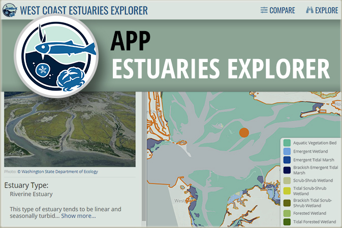
This application enables you to compare estuaries to each other along the coastlines of Washington, Oregon, and California. You can combine dynamic filters and an interactive map to find specific estuary types you are interested in, such as large river delta estuaries which often have extensive diking; small, riverine estuaries that are at the lowest risk to fish habitat degradation; or estuaries contain species that interest you. Only want to compare estuaries in a specific area? Simply zoom the map in to that area, and the filters automatically update to show you the number of estuaries in that area that meet different conditions. You can also explore estuaries in more detail to find a specific estuary by name...
A storymap that allows users to learn about the Western Native Trout Initiative and explore stories of five native trout and their triumphs of restoration, collaboration, conservation, education, and protection.
This map viewer highlights spatial data products developed by PMEP to characterize habitats and synthesize information in support of habitat conservation and restoration goal setting. Most of the data presented in this viewer are available at https://www.pacificfishhabitat.org/data.
The Species-Habitat Matrix is an evaluation of the importance of benthic habitats as space for shelter, feeding, and breeding by coastal fishes and motile invertebrates in ACFHP’s four subregions. The analysis quantified the relationship between over 100 different species across four life stages and 26 different habitats.
The Midwest Glacial Lakes Partnership’s Conservation Planner provides data to inform communication, management, and research to benefit fish habitat and lake ecosystems. The Conservation Planner has two panels; the upper Map Panel is an interactive map capable of displaying information for a large number of lakes, while the lower Data Panel shows specific information about a single lake that the user selects including climate vulnerability, watershed disturbance, shoreland disturbance, predicted suitability, watershed management guidelines, shoreland management guidelines, watershed details, and shoreland details.
|

|
