Filters: Tags: Airborne Lidar (X)
7 results (41ms)|
Filters
Date Range
Types Contacts
Tag Types Tag Schemes |
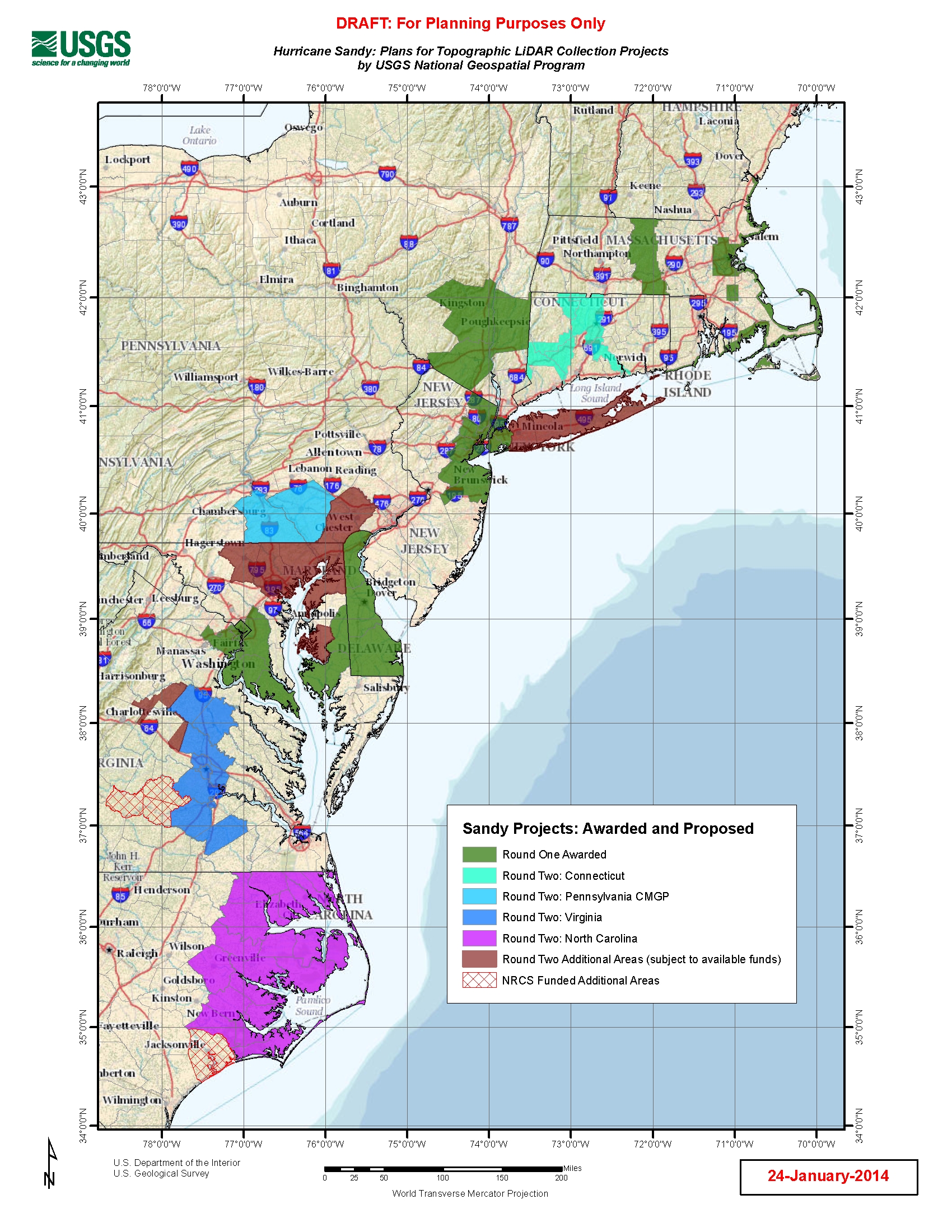
U.S. Geological Survey, Department of the Interior - The Hurricane Sandy Supplemental Funding lidar and DEM acquisition plan is part of the 3DEP initiative to systematically collect enhanced elevation data (Quality Level 2) in the form of high-quality light detection and ranging (lidar) data over the conterminous United States, Hawaii, and the territories on an 8-year schedule. The FY14 Hurricane Sandy acquisition plan currently anticipates collecting 20,000 - 30,000 sq. mi. within the impacted area. Exact area collected will depend on partnerships and other contributions to the plan. Interested parties who wish to become a funding partner with the USGS FY14 or in future years should contact a USGS Geospatial Liaison...
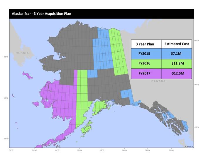
U.S. Geological Survey, Department of the Interior - The annual Alaska IfSAR and DEM acquisition plan is part of the 3DEP initiative to collect high-quality elevation data in the form of interferometric synthetic aperture radar (IfSAR) and light detection and ranging (lidar) data over Alaska. This acquisition plan addresses concerns raised in GAO Report 13-94 regarding geospatial coordination, and supports FGDC data coordination initiatives led by the Department of Interior's Geospatial Information Officer. Mapping a State the size and complexity of Alaska through a partnered effort such as the Alaska Mapping Initiative requires dedicated collaboration and coordination across multiple levels of government. State...
U.S. Geological Survey, Department of the Interior - The annual lidar and DEM acquisition plan is part of the 3DEP initiative to systematically collect enhanced elevation data (Quality Level 2) in the form of high-quality light detection and ranging (lidar) data over the conterminous United States, Hawaii, and the territories on an 8-year schedule. The FY17 acquisition plan currently anticipates collecting 225,000 sq. mi. or more depending on partnerships and other contributions to the plan. Interested parties who wish to become a funding partner with the USGS in FY17 or in future years should contact a USGS Geospatial Liaison - http://liaisons.usgs.gov/geospatial/documents/TNM_Partnership_User_ContactList.pdf....
U.S. Geological Survey (USGS) scientists conducted field data collection efforts between July 19th and 31st, 2021 over a large stretch of the McKenzie River in Oregon using high accuracy surveying technologies. The work was initiated as an effort to validate commercially acquired topobathymetric light detection and ranging (lidar) data that was collected coincidentally between July 26th and 30th, 2021 for the USGS 3D Elevation Program (3DEP). The goal was to compare and validate the airborne lidar data to topographic, bathymetric, structural, and infrastructural data collected through more traditional means (e.g., Global Navigational Satellite System (GNSS) surveying). Evaluating these data will provide valuable...
U.S. Geological Survey, Department of the Interior - The annual Alaska IfSAR and DEM acquisition plan is part of the 3DEP initiative to collect high-quality elevation data in the form of interferometric synthetic aperture radar (IfSAR) and light detection and ranging (lidar) data over Alaska. This acquisition plan addresses concerns raised in GAO Report 13-94 regarding geospatial coordination, and supports FGDC data coordination initiatives led by the Department of Interior's Geospatial Information Officer. Mapping a State the size and complexity of Alaska through a partnered effort such as the Alaska Mapping Initiative requires dedicated collaboration and coordination across multiple levels of government. State...
U.S. Geological Survey, Department of the Interior - The annual lidar and DEM acquisition plan is part of the 3DEP initiative to systematically collect enhanced elevation data (Quality Level 2) in the form of high-quality light detection and ranging (lidar) data over the conterminous United States, Hawaii, and the territories on an 8-year schedule. The FY14 acquisition plan currently anticipates collecting 100,000 sq. mi. or more depending on partnerships and other contributions to the plan. Interested parties who wish to become a funding partner with the USGS in FY14 or in future years should contact a USGS Geospatial Liaison - http://liaisons.usgs.gov/geospatial/documents/TNM_Partnership_User_ContactList.pdf....
U.S. Geological Survey (USGS) scientists conducted field data collection efforts between August 17th and 28th, 2020 over a large stretch of the Niobrara River in Nebraska using high accuracy surveying technologies. The work was initiated as an effort to validate commercially acquired topobathymetric light detection and ranging (lidar) data. The goal was to compare and validate the airborne lidar data to topographic, bathymetric, structural, and infrastructural data collected through more traditional means (e.g. Global Navigational Satellite System (GNSS) surveying). The airborne topobathymetric lidar data will be used for characterization of endangered species aquatic habitat, improving the understanding of fluvial...
|

|
