Filters: Tags: Alberta (X)
303 results (80ms)|
Filters
Date Range
Extensions
Types Contacts
Categories Tag Types
|
Layered geospatial PDF Map. Layers of geospatial data include orthoimagery, roads, grids, geographic names, elevation contours, hydrography, and other selected map features.
Layered GeoPDF 7.5 Minute Quadrangle Map. Layers of geospatial data include orthoimagery, roads, grids, geographic names, elevation contours, hydrography, and other selected map features.
Layered geospatial PDF Map. Layers of geospatial data include orthoimagery, roads, grids, geographic names, elevation contours, hydrography, and other selected map features.
Overview This directory was developed to provide discovery information for anyone looking for publicly accessible repositories that house geological materials in the U.S. and Canada. In addition, this resource is intended to be a tool to facilitate a community of practice. The need for the directory was identified during planning for and follow-up from a drill core repository webinar series in Spring 2020 for public repository curators and staff in the U.S. and Canada hosted by the Minnesota Geological Survey and the Minnesota Department of Natural Resources. Additional supporting sponsors included the U.S. Geological Survey National Geological and Geophysical Data Preservation Program and the Association of American...
Categories: Data;
Types: Downloadable,
Map Service,
OGC WFS Layer,
OGC WMS Layer,
Shapefile;
Tags: Alabama,
Alaska,
Alberta,
Arkansas,
British Columbia,
Layered GeoPDF 7.5 Minute Quadrangle Map. Layers of geospatial data include orthoimagery, roads, grids, geographic names, elevation contours, hydrography, and other selected map features.
Layered GeoPDF 7.5 Minute Quadrangle Map. Layers of geospatial data include orthoimagery, roads, grids, geographic names, elevation contours, hydrography, and other selected map features.
Layered geospatial PDF Map. Layers of geospatial data include orthoimagery, roads, grids, geographic names, elevation contours, hydrography, and other selected map features.
These data were compiled as a supplement to a previously published journal article (Bradford et al., 2019), that employed a ecosystem water balance model to characterize current and future patterns in soil temperature and moisture conditions in dryland areas of western North America. Also, these data are associated with a published USGS data release (Bradford and Schlaepfer, 2019). The objectives of our study were to (1) characterize current and future patterns in soil temperature and moisture conditions in dryland areas of western North America, (2) evaluate the impact of these changes on estimation of resilience and resistance among a representative set of climate scenarios. These data represent geographic patterns...
Greater sage-grouse population components devrived using an 18-km maximum connection distance. Analysis was conducted using the CONEFOR SENSINODE 2.2 software package and this dataset was developed from lek data obtained from the state wildlife agencies. Components containing < 5 leks have been removed in order to protect the location of single or small groups of leks.
Categories: Data;
Types: Downloadable,
Map Service,
OGC WFS Layer,
OGC WMS Layer,
Shapefile;
Tags: Alberta,
Arizona,
British Columbia,
California,
Canada,
This map was developed to examine multi-scale spatial relationships between percentage of sagebrush and other response variables of interest. A map of sagebrush in the western United States was used as a base layer for a moving window analysis to calculate the percentage of the area classified as sagebrush within a 5-km search radius.
USGS Historical Quadrangle in GeoPDF.
This workshop introduced and demonstrated key concepts and a series of software tools, whichallow managers, biologists, and conservationists to efficiently evaluate predictors of wildlife space-use and generate spatial models based on that analysis.Specific content of the workshop: Access to free or low-cost remote sensing information on vegetation, climate, habitat metrics, disturbance, etc., in a useable format, including covariate datasets currently available or under development by the NASA Terrestrial Observation and Prediction System (TOPS) Explanation of how this information is derived, created, integrated, validated and matched with species data sets prior to analysis Demonstration of user-friendly computer...
Categories: Data,
Project;
Types: Map Service,
OGC WFS Layer,
OGC WMS Layer,
OGC WMS Service;
Tags: Academics & scientific researchers,
Alberta,
British Columbia,
CO-2,
CO-3,
Defenders staff, contractors and Great Northern Landscape Conservation Cooperative partners will build a portal on the Conservation Registry to visualize landscape scale plans and conservation projects that address the priorities of the program. The portal will integrate with GN LCCs existing project management tool, LC Map, to spatially display plans within the geographic area of the LCC, provide information about the plans, and link to planning documents. services and/or data imports will be programmed to facilitate efficient transfer of project data from LC Map and other agencies and organizations into the Registry. FY2012Objectives: Coordination with Heart of the Rockies (HotR) staff to identify focal area,...
Categories: Data,
Project;
Types: Map Service,
OGC WFS Layer,
OGC WMS Layer,
OGC WMS Service;
Tags: Academics & scientific researchers,
Alberta,
British Columbia,
Climate Change,
Connectivity,
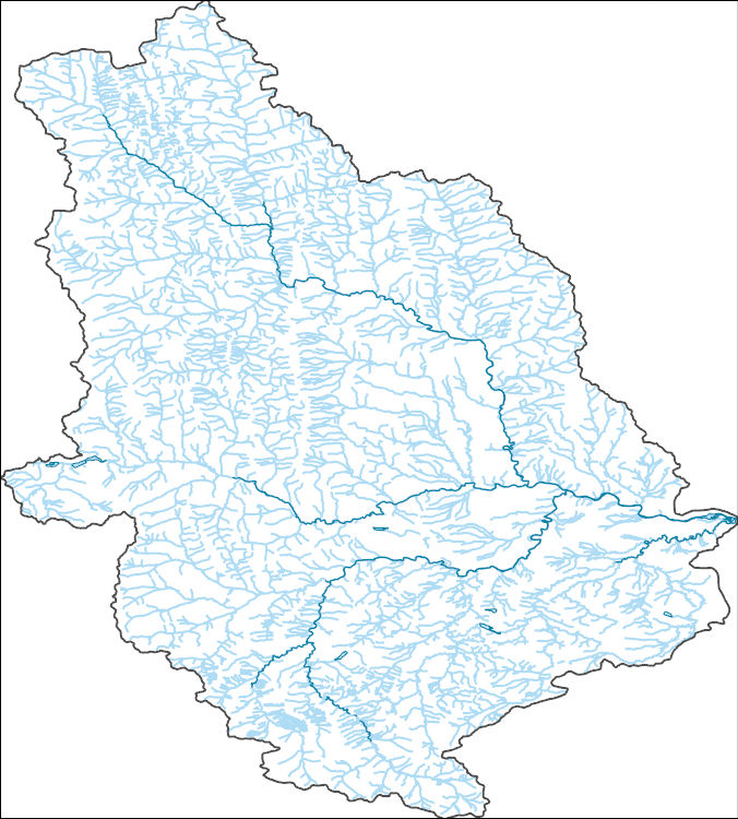
The National Hydrography Dataset (NHD) is a feature-based database that interconnects and uniquely identifies the stream segments or reaches that make up the nation's surface water drainage system. NHD data was originally developed at 1:100,000-scale and exists at that scale for the whole country. This high-resolution NHD, generally developed at 1:24,000/1:12,000 scale, adds detail to the original 1:100,000-scale NHD. (Data for Alaska, Puerto Rico and the Virgin Islands was developed at high-resolution, not 1:100,000 scale.) Local resolution NHD is being developed where partners and data exist. The NHD contains reach codes for networked features, flow direction, names, and centerline representations for areal water...
The National Hydrography Dataset (NHD) is a feature-based database that interconnects and uniquely identifies the stream segments or reaches that make up the nation's surface water drainage system. NHD data was originally developed at 1:100,000-scale and exists at that scale for the whole country. This high-resolution NHD, generally developed at 1:24,000/1:12,000 scale, adds detail to the original 1:100,000-scale NHD. (Data for Alaska, Puerto Rico and the Virgin Islands was developed at high-resolution, not 1:100,000 scale.) Local resolution NHD is being developed where partners and data exist. The NHD contains reach codes for networked features, flow direction, names, and centerline representations for areal water...
The RCMAP (Rangeland Condition Monitoring Assessment and Projection) dataset quantifies the percent cover of rangeland components across western North America using Landsat imagery from 1985-2023. The RCMAP product suite consists of ten fractional components: annual herbaceous, bare ground, herbaceous, litter, non-sagebrush shrub, perennial herbaceous, sagebrush, shrub, tree, and shrub height in addition to the temporal trends of each component. Several enhancements were made to the RCMAP process relative to prior generations. First, high-resolution training was revised using an improved neural-net classifier and modelling approach. These data serve as foundation to the RCMAP approach. The training database was...
The RCMAP (Rangeland Condition Monitoring Assessment and Projection) dataset quantifies the percent cover of rangeland components across western North America using Landsat imagery from 1985-2023. The RCMAP product suite consists of ten fractional components: annual herbaceous, bare ground, herbaceous, litter, non-sagebrush shrub, perennial herbaceous, sagebrush, shrub, tree, and shrub height in addition to the temporal trends of each component. Several enhancements were made to the RCMAP process relative to prior generations. First, high-resolution training was revised using an improved neural-net classifier and modelling approach. These data serve as foundation to the RCMAP approach. The training database was...
In May 2014, the GNLCC Steering Committee approved two pilot projects explore approaches to landscape-scale coordination to enhance science-based management across the GNLCC. The two ‘Shared Landscape Outcomes’ pilots were designed to assess and focus on specific pairs of a GNLCC Goal and a priority landscape stressor (as defined in the Strategic Conservation Framework) and focus the approach at the entire GNLCC scale. The two pilot projects focused on (1) the Connectivity goal and Land Use Change stressor (described here) and (2) the Aquatic Integrity goal and Invasives stressor and (see: https://www.fws.gov/science/catalog )Connectivity Pilot:Wildlife species are becoming increasingly isolated in patches of habitat,...
Categories: Data,
Project;
Types: Map Service,
OGC WFS Layer,
OGC WMS Layer,
OGC WMS Service;
Tags: Alberta,
Aquatic Connectivity,
British Columbia,
Bull Trout,
Cascadia,
This data release contains historical SnowModel (Liston and Elder, 2006) output for the Crown of the Continent and surrounding areas in Montana and Idaho, USA; and Alberta and British Columbia, Canada from September 1, 1981 through August 31, 2020. Fifteen daily variables were simulated or derived for this release: (1) snow water equivalent (swed), (2) liquid precipitation (rpre), (3) solid precipitation (spre), (4) albedo (albd), (5) glacial ice melt (glmt), (6) total precipitation (prec), (7) runoff (roff), (8) snow covered area (sca), (9) snow density (sden), (10) snowmelt (smlt), (11) snow depth (snod), (12) snow sublimation (ssub), (13) air temperature (tair), (14) wind speed (wspd), and (15) wind direction...
Categories: Data;
Types: Downloadable,
Map Service,
OGC WFS Layer,
OGC WMS Layer,
Shapefile;
Tags: Alberta,
British Columbia,
Crown of the Continent,
Glacier National Park,
Idaho,
Conclusions:Report presents draft outcomes, indicators, and targets for the Red Deer River Basin in three topic areas: wetlands, riparian areas, and land use. Targets established were based on a detailed literature review, combined with Geographic Information Systems (GIS) queries of existing conditions.Thresholds/Learnings:Specific thresholds for the region include: wetland cover should comprise >7.5% of the watershed; peatland cover should comprise > 6.0% in the upper headwaters; 82% of all riparian areas (variable width) in the watershed should have perennial vegetation cover; 97% of all riparian areas (variable width) in the Upper Headwaters should have perennial vegetation cover
Categories: Publication;
Types: Citation;
Tags: Alberta,
Land use configuration,
Landscape fragmentation,
Natural cover amount,
Natural cover heterogeneity,
|

|
